

Kau, Hawaii
Encyclopedia

Hawaii (island)
The Island of Hawaii, also called the Big Island or Hawaii Island , is a volcanic island in the North Pacific Ocean...
.
Kaū was one of the six original districts of ancient Hawaii
Ancient Hawaii
Ancient Hawaii refers to the period of Hawaiian human history preceding the unification of the Kingdom of Hawaii by Kamehameha the Great in 1810. After being first settled by Polynesian long-distance navigators sometime between AD 300–800, a unique culture developed. Diversified agroforestry and...
on the island, known as moku.
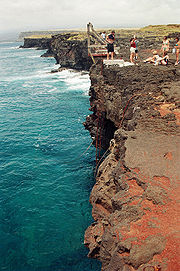
It includes the areas of South Point (Ka Lae)
Ka Lae
Ka Lae , also known as South Point, is the southernmost point of the Big Island of Hawaii and of the 50 United States. The Ka Lae area is registered as a National Historic Landmark District under the name South Point Complex...
, Hawaiian Ocean View Estates (HOVE), Hawaiian Ocean View Ranchos (HOVR), now together known as Ocean View, Nīnole
Ninole, Hawaii
Nīnole is the name of two unincorporated communities on the island of Hawaii in Hawaii County, Hawaii, United States. In the Hawaiian language Nīnole means "bending"...
, Waiōhinu, Naālehu and Pāhala.
The district contains much of Hawaii Volcanoes National Park
Hawaii Volcanoes National Park
Hawaii Volcanoes National Park, established in 1916, is a United States National Park located in the U.S. State of Hawaii on the island of Hawaii. It encompasses two active volcanoes: Kīlauea, one of the world's most active volcanoes, and Mauna Loa, the world's most massive volcano...
, including the volcanoes Kīlauea
Kilauea
Kīlauea is a volcano in the Hawaiian Islands, and one of five shield volcanoes that together form the island of Hawaii. Kīlauea means "spewing" or "much spreading" in the Hawaiian language, referring to its frequent outpouring of lava. The Puu Ōō cone has been continuously erupting in the eastern...
and Mauna Loa
Mauna Loa
Mauna Loa is one of five volcanoes that form the Island of Hawaii in the U.S. state of Hawaii in the Pacific Ocean, and the largest on Earth in terms of volume and area covered. It is an active shield volcano, with a volume estimated at approximately , although its peak is about lower than that...
, and Punaluu Black Sand Beach, Papakōlea (Green Sand) Beach and Kamilo Beach
Kamilo Beach
Kamilo Beach , is a beach located on the southeast coast of the island of Hawaii...
.
To the east of Kaū is the Puna District
Puna, Hawaii
Puna is one of the nine districts in Hawaii County, Big Island, Hawaii. The District of Puna is located on the easternmost portion of the island and shares borders to the north with the District of South Hilo and a border to the west with the District of Kaū...
, and to the west is the South Kona District
Kona District, Hawaii
Kona is the name of a moku or district on the Big Island of Hawaii in the State of Hawaii. In the current system of administration of Hawaii County, the moku of Kona is divided into North Kona District and South Kona District . The term "Kona" is sometimes used to refer to its largest town,...
.
Sugar cane was a large crop until 1996. Now coffee is growing in importance, with the Kaū Coffee Festival held in Pāhala.
The Southernmost point of the US is at Ka Lae Point in the Kaū District. However, although Palmyra Atoll
Palmyra Atoll
Palmyra Atoll is an essentially unoccupied equatorial Northern Pacific atoll administered as an unorganized incorporated territory by the United States federal government...
is an unorganized
Unorganized territory
An unorganized territory is a region of land without a "normally" constituted system of government. This does not mean that the territory has no government at all or that it is unclaimed territory...
incorporated territory
Incorporated territory
Territories of the United States are one of the four types of political division of the United States, overseen directly by the federal government of the United States and not any part of a U.S. state. These territories were created to govern newly acquired land while the borders of the United...
by the United States federal government and not part of a state within the US, the atoll is officially the most southern.

Lender and Insurance Redlining Of Lava Zone 1 and 2
Kau shares much in common with the district of Puna, HawaiiPuna, Hawaii
Puna is one of the nine districts in Hawaii County, Big Island, Hawaii. The District of Puna is located on the easternmost portion of the island and shares borders to the north with the District of South Hilo and a border to the west with the District of Kaū...
. Both districts are situated on active volcanoes and contains large sections of land that are in Lava Flow Hazard Zones 1 and 2. Additionally, new lava zones 11, 12, and 13 are being established to account for current flow activity to reduce redlining
Redlining
Redlining is the practice of denying, or increasing the cost of services such as banking, insurance, access to jobs, access to health care, or even supermarkets to residents in certain, often racially determined, areas. The term "redlining" was coined in the late 1960s by John McKnight, a...
.