

Hong Kong Strategic Route and Exit Number System
Encyclopedia

Transport Department (Hong Kong)
Transport Department is responsible for transportation related policy in Hong Kong. The department reports to the Transport and Housing Bureau.The current Commissioner for Transport is Joseph Lai.-See also:* Transport in Hong Kong...
of the Hong Kong
Hong Kong
Hong Kong is one of two Special Administrative Regions of the People's Republic of China , the other being Macau. A city-state situated on China's south coast and enclosed by the Pearl River Delta and South China Sea, it is renowned for its expansive skyline and deep natural harbour...
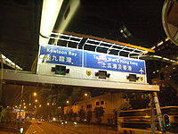
Government to organise the major roads in the territory into Routes 1 to 10 for the convenience of drivers. When the system was first implemented in 2004, the government launched a large campaign to promote it to the public. One of the slogans is "Remember the Numbers; Make Driving Easier" (認路記號碼,唔使路路查).
The system comprises nine major series of roads in Hong Kong, numbered Routes 1 to 5 and 7 to 10, which can be classified into three categories: the three north-south routes, the five east-west routes and the New Territories
New Territories
New Territories is one of the three main regions of Hong Kong, alongside Hong Kong Island and the Kowloon Peninsula. It makes up 86.2% of Hong Kong's territory. Historically, it is the region described in The Convention for the Extension of Hong Kong Territory...
Circular Road. The route numbers are represented as black on yellow "road-shields"
Highway shield
A highway shield is a sign denoting the route number of a highway, usually in the form of a symbolic shape with the route number enclosed. As the focus of the sign, the route number is usually the sign's largest element, with other items on the sign rendered in smaller sizes or contrasting colours...
on overhead roadsigns.
The system also implemented exit number
Exit number
An exit number is a number assigned to a road junction, usually an exit from a freeway. It is usually marked on the same sign as the destinations of the exit, as well as a sign in the gore....
ing on the aforementioned routes. The exits of each route are numbered sequentially; some exit numbers are suffixed with a letter of the alphabet. Exit numbers are indicated by white in black rectangular boxes on overhead and roadside signs.
Route number system
Route 1 (Hong Kong)
Route 1 in Hong Kong is a major artery that runs in a generally north-south direction from Aberdeen to Sha Tin.The route begins at Aberdeen Praya Road in southern Hong Kong Island, which then turns into Wong Chuk Hang Road...
, Route 2
Route 2 (Hong Kong)
Route 2 of Hong Kong runs from Quarry Bay of Hong Kong Island to Ma Liu Shui of the New Territories, formerly known as route 6, and renamed as route 2 in 2004 under the route numbering scheme proposed in the same year....
, and Route 3
Route 3 (Hong Kong)
Route 3 is a series of expressways in Hong Kong from Sai Ying Pun on the Hong Kong Island to Yuen Long in the New Territories, via Yau Ma Tei, Kwai Chung and Tsing Yi Island.From south to north, Route 3 can be divided into four parts...
. They connect Hong Kong Island
Hong Kong Island
Hong Kong Island is an island in the southern part of the Hong Kong Special Administrative Region. It has a population of 1,289,500 and its population density is 16,390/km², as of 2008...
, metro Kowloon
Kowloon
Kowloon is an urban area in Hong Kong comprising the Kowloon Peninsula and New Kowloon. It is bordered by the Lei Yue Mun strait in the east, Mei Foo Sun Chuen and Stonecutter's Island in the west, Tate's Cairn and Lion Rock in the north, and Victoria Harbour in the south. It had a population of...
and the New Territories via a series of flyover
Overpass
An overpass is a bridge, road, railway or similar structure that crosses over another road or railway...
s and tunnel
Tunnel
A tunnel is an underground passageway, completely enclosed except for openings for egress, commonly at each end.A tunnel may be for foot or vehicular road traffic, for rail traffic, or for a canal. Some tunnels are aqueducts to supply water for consumption or for hydroelectric stations or are sewers...
s. They pass through the three tunnels crossing Victoria Harbour
Victoria Harbour
Victoria Harbour is a natural landform harbour situated between Hong Kong Island and the Kowloon Peninsula in Hong Kong. The harbour's deep, sheltered waters and strategic location on the South China Sea were instrumental in Hong Kong's establishment as a British colony and its subsequent...
, and their sequence of numbering follows the order of opening dates of the three tunnels:
- Route 1Route 1 (Hong Kong)Route 1 in Hong Kong is a major artery that runs in a generally north-south direction from Aberdeen to Sha Tin.The route begins at Aberdeen Praya Road in southern Hong Kong Island, which then turns into Wong Chuk Hang Road...
: Cross-Harbour TunnelCross-Harbour TunnelThe Cross-Harbour Tunnel is the first tunnel in Hong Kong built underwater. It has become one of the most congested roads in Hong Kong and the world...
(opened 1972) - Route 2Route 2 (Hong Kong)Route 2 of Hong Kong runs from Quarry Bay of Hong Kong Island to Ma Liu Shui of the New Territories, formerly known as route 6, and renamed as route 2 in 2004 under the route numbering scheme proposed in the same year....
: Eastern Harbour Tunnel (opened 1989; formerly Route 6) - Route 3Route 3 (Hong Kong)Route 3 is a series of expressways in Hong Kong from Sai Ying Pun on the Hong Kong Island to Yuen Long in the New Territories, via Yau Ma Tei, Kwai Chung and Tsing Yi Island.From south to north, Route 3 can be divided into four parts...
: Western Harbour CrossingWestern Harbour CrossingThe Western Harbour Crossing is a dual 3-lane immersed tube tunnel in Hong Kong. It is the third tunnel to cross Victoria Harbour, linking the newly reclaimed land in West Kowloon with Sai Ying Pun on Hong Kong Island...
(opened 1997)
The five east-west routes — Route 4
Route 4 (Hong Kong)
Route 4 is an east-west road artery along the north shore of Hong Kong Island, Hong Kong. Formerly divided into routes 7 and 8, Route 4 consists of two sections:...
, Route 5
Route 5 (Hong Kong)
Route 5 is a route artery in Hong Kong from eastern to western Kowloon and New Kowloon, and ends in Tsuen Wan in the New Territories, linking Route 9....
, Route 7
Route 7 (Hong Kong)
Route 7 is a highway route running through New Kowloon in Hong Kong between Tseung Kwan O and Kwai Chung.The first sections of road were built as a 5 lane trunk road , it was expanded to the current 6 lane highway...
, Route 8
Route 8 (Hong Kong)
Route 8 of Hong Kong is an 3-lane carriageway dual 3-lane highway that links Lantau Island, Tsing Yi Island, Cheung Sha Wan in West Kowloon, and Sha Tin in the Northeast New Territories of Hong Kong. It is a combination of many sections....
and Route 10
Route 10 (Hong Kong)
Route 10 is the newest trunk route in the Hong Kong Strategic Route and Exit Number System. It is a 10.9 km dual carriageway with three lanes in each direction, consisting of the Kong Sham Western Highway and the Hong Kong-Shenzhen Western Corridor, connecting the Yuen Long Highway in Lam...
— are numbered from south to north. The pattern indicates that Route 6
Route 6 (Hong Kong)
Route 6 is a road route number reserved for future use by the Hong Kong Government. It is proposed to run through central Kowloon in Hong Kong and is marked as a high-priority trunk route in the Third Comprehensive Transport Study....
will most likely be built between Routes 5 and 7. Route 4 runs along the north shore of Hong Kong Island, connecting the eastern and western ends of the island, whereas Routes 5 and 7 link southern New Territories with different parts of Kowloon. Route 8 provides direct access to Chek Lap Kok Airport
Hong Kong International Airport
Hong Kong International Airport is the main airport in Hong Kong. It is colloquially known as Chek Lap Kok Airport , being built on the island of Chek Lap Kok by land reclamation, and also to distinguish it from its predecessor, the closed Kai Tak Airport.The airport opened for commercial...
, and is currently being extended. Route 10 provides access to the border crossing at Shekou
Shekou
Shekou is an area at the tip of Nantou Peninsula in Shenzhen, Guangdong, southern China, south of Nantou and facing Lau Fau Shan of Hong Kong across Deep Bay.It was formerly a customs station in Bao'an County and now belongs to Nanshan District of Shenzhen...
, Shenzhen
Shenzhen
Shenzhen is a major city in the south of Southern China's Guangdong Province, situated immediately north of Hong Kong. The area became China's first—and one of the most successful—Special Economic Zones...
.
- Route 4Route 4 (Hong Kong)Route 4 is an east-west road artery along the north shore of Hong Kong Island, Hong Kong. Formerly divided into routes 7 and 8, Route 4 consists of two sections:...
: formerly Routes 7 and 8 (opened 1990) - Route 5Route 5 (Hong Kong)Route 5 is a route artery in Hong Kong from eastern to western Kowloon and New Kowloon, and ends in Tsuen Wan in the New Territories, linking Route 9....
: formerly Tsuen Wan - Ngau Tau Kok section of Route 2 (opened 1970-1980s) - Route 7Route 7 (Hong Kong)Route 7 is a highway route running through New Kowloon in Hong Kong between Tseung Kwan O and Kwai Chung.The first sections of road were built as a 5 lane trunk road , it was expanded to the current 6 lane highway...
: formerly Route 4 (opened 1970s) - Route 8Route 8 (Hong Kong)Route 8 of Hong Kong is an 3-lane carriageway dual 3-lane highway that links Lantau Island, Tsing Yi Island, Cheung Sha Wan in West Kowloon, and Sha Tin in the Northeast New Territories of Hong Kong. It is a combination of many sections....
: formerly Route 9 (Tsing Yi - Airport section opened 1997; Tsing Yi - Cheung Sha Wan section opened December 2009; Cheung Sha Wan - Sha Tin section opened 2008) - Route 10Route 10 (Hong Kong)Route 10 is the newest trunk route in the Hong Kong Strategic Route and Exit Number System. It is a 10.9 km dual carriageway with three lanes in each direction, consisting of the Kong Sham Western Highway and the Hong Kong-Shenzhen Western Corridor, connecting the Yuen Long Highway in Lam...
(opened 2007)
The circular route, Route 9
Route 9 (Hong Kong)
Route 9 , Hong Kong is one of the strategic trunk roads, mostly in the form of an freeway, circumnavigating the New Territories. The route was also known as the New Territories Circular Orbital Beltway Ring Road...
, circumscribes the New Territories, with the exit at the Shing Mun Tunnels
Shing Mun Tunnels
The Shing Mun Tunnels are a system of tunnels and viaducts in the New Territories, Hong Kong connecting the new towns of Tsuen Wan to the west and Sha Tin to the east. It is part of Route 9....
in Sha Tin
Sha Tin
Sha Tin, also spelled Shatin, is an area around the Shing Mun River in the New Territories of Hong Kong. Administratively, it is part of the Sha Tin District.-Geography:...
as the starting point of exit-numbering. It links up the network of expressways
Controlled-access highway
A controlled-access highway is a highway designed exclusively for high-speed vehicular traffic, with all traffic flow and ingress/egress regulated...
and trunk roads in the New Territories into a large ring.
- Route 9: formerly Route 5 + Fo Tan - Lok Ma Chau section of Route 1 + Tsuen Wan - Lok Ma Chau section of Route 2 (construction from 1974–2007)
Exit number system
In parallel with route numbering, the junctions between routes and exits from routes are also labelled with exit numberExit number
An exit number is a number assigned to a road junction, usually an exit from a freeway. It is usually marked on the same sign as the destinations of the exit, as well as a sign in the gore....
s. On every route, exits are numbered from one end to the other with ascending consecutive integers with a mixture of alphabet-suffixed labels (1, 2, 2A, 2B, 3, 4... etc).
First generation
The first generation of the route number system in Hong Kong was envisaged in the 1968 Hong Kong Long Term Road Study by Freeman, Fox, Wilbur Smith & Associates, in which trunk routes were given single-digit numbers, and distributors with double-digit ones. Also included in the road study was an unnumbered Western Harbour Crossing (WHC), which in the plan involved a bridge crossing the Victoria HarbourVictoria Harbour
Victoria Harbour is a natural landform harbour situated between Hong Kong Island and the Kowloon Peninsula in Hong Kong. The harbour's deep, sheltered waters and strategic location on the South China Sea were instrumental in Hong Kong's establishment as a British colony and its subsequent...
between Cherry Street
Cherry Street, Hong Kong
Cherry Street is a street in Tai Kok Tsui, Kowloon, Hong Kong. It was a street to Tai Kok Tsui Ferry Pier. After the reclamation of the West Kowloon in 1990s, it became a road across the new reclamation and a tunnel was built under the Olympic Station....
in Mong Kok
Mong Kok
Mong Kok , less often known as Argyle , is an area in the Yau Tsim Mong District on Kowloon Peninsula, Hong Kong...
and Kennedy Town
Kennedy Town
Kennedy Town is at the western end of Sai Wan on Hong Kong Island in Hong Kong. It was named after Arthur Edward Kennedy, the 7th Governor of Hong Kong from 1872 to 1877...
, by way of Stonecutters Island
Stonecutters Island
Stonecutters Island or Ngong Shuen Chau is a former island in Victoria Harbour, Hong Kong. Following land reclamation, it is now annexed to the Kowloon peninsula.-Fauna:...
and Green Island
Green Island, Hong Kong
Green Island is an island off the northwest coast of Kennedy Town on the Hong Kong Island in Hong Kong, separated by the Sulphur Channel. A smaller island nearby to the east, uninhabited, is called Little Green Island...
.
Numbered routes included in the study were:
- 1: AberdeenAberdeen (Hong Kong)Aberdeen is a town on the south shore of Hong Kong Island in Hong Kong. Administratively, it is part of the Southern District. Aberdeen Harbour is a harbour between Aberdeen and Ap Lei Chau. The name 'Aberdeen' usually covers the areas of Aberdeen, Wong Chuk Hang and Ap Lei Chau, but it is more...
to FanlingFanlingFanling , also known as Fan Ling and Fan Leng, is an area in the New Territories of Hong Kong. Administratively, it is part of the North District...
, via Aberdeen TunnelAberdeen TunnelAberdeen Tunnel is a two-tube tunnel linking Happy Valley and Wong Chuk Hang near Aberdeen on the Hong Kong Island, Hong Kong. It shortens the travel time between the north and the south of the Hong Kong Island. It connects the Wong Chuk Hang Road in the south, and Canal Road Flyover in the...
, Cross Harbour Tunnel, Lion Rock TunnelLion Rock TunnelThe Lion Rock Tunnel, being the first tunnel in Hong Kong, is a twin-bored toll tunnel, connecting Sha Tin in the New Territories and New Kowloon near Kowloon Tong. It has two lanes in each direction, with toll booths located at the Sha Tin end. It is a vital component of Route 1.The Lion Rock...
, Tai Po RoadTai Po RoadTai Po Road is the second longest road in Hong Kong . It spans from Sham Shui Po in Kowloon to Tai Po in the New Territories of Hong Kong. Initially, the road was named Frontier Road....
- 11: Ngau Tau KokNgau Tau KokNgau Tau Kok is an area of Kowloon, Hong Kong, located at the northern part of Kwun Tong District, next to Kowloon Bay. It covers Jordan Valley, Ngau Tau Kok and Upper Kwun Tong town centre. The population of Ngau Tau Kok exceeds 210,000...
to Butterfly Valley Interchage, via Prince Edward Road East, Prince Edward Road West and Lai Chi Kok RoadLai Chi Kok RoadLai Chi Kok Road is a road in the western part of New Kowloon, Hong Kong. It links Lai Chi Kok to Mong Kok, via Tai Kok Tsui, Sham Shui Po and Cheung Sha Wan. It starts from the junction with Nathan Road near Pioneer Centre in the south and ends near Mei Foo Sun Chuen...
for westbound, Cheung Sha Wan RoadCheung Sha Wan RoadCheung Sha Wan Road is the most major road in western urban New Kowloon of Hong Kong. It starts from Sham Shui Po, passes through Cheung Sha Wan, and ends near Lai Chi Kok.-Route:...
and Boundary StreetBoundary Street[[Image:Boundary st hongkong.JPG|thumb|right|250px|Boundary Street near [[Kowloon Tong]]Boundary Street is a three-lane one-way street in [[Kowloon]], [[Hong Kong]]...
for eastbound - 12: Kowloon CityKowloon CityKowloon City is an area in Kowloon, Hong Kong. It is named after the Kowloon Walled City, and is administratively part of Kowloon City District....
to Mong KokMong KokMong Kok , less often known as Argyle , is an area in the Yau Tsim Mong District on Kowloon Peninsula, Hong Kong...
, via Argyle StreetArgyle Street, Hong KongArgyle Street is a four-lane dual-way thoroughfare in Hong Kong, connecting Mong Kok, Ma Tau Wai and Kowloon City. It runs on an east-west alignment starting at its intersection with Cherry Street, Ferry Street and Tong Mi Road in the west, and ending near the former Kai Tak Airport in the east.The...
and Cherry StreetCherry Street, Hong KongCherry Street is a street in Tai Kok Tsui, Kowloon, Hong Kong. It was a street to Tai Kok Tsui Ferry Pier. After the reclamation of the West Kowloon in 1990s, it became a road across the new reclamation and a tunnel was built under the Olympic Station....
, connecting to WHC - 14: connecting routes 1 and 4, via Choi Hung Road and Po Kong Village Road
- 11: Ngau Tau Kok
- 2: Junction between route 1 and Chatham RoadChatham RoadChatham Road South and Chatham Road North are two continuous roads spanning from Tsim Sha Tsui to Hung Hom in Kowloon, Hong Kong. The road originally ran from Signal Hill to Hung Hom under No. 12 Hill by the side of Hung Hom Bay...
to Sheung ShuiSheung ShuiSheung Shui is an area in New Territories, Hong Kong. Sheung Shui Town, a part of this area, is part of the Fanling-Sheung Shui New Town in the North District of Hong Kong. Fanling Town is to its southeast.-History:...
, via Gascoigne RoadGascoigne RoadGascoigne Road is a main road in Kowloon, Hong Kong, going through the head of King's Park and leading vehicles from West Kowloon to the Cross-Harbour Tunnel, name after William Julius Gascoigne....
, West Kowloon CorridorWest Kowloon CorridorWest Kowloon Corridor is part of Route 5 in Hong Kong. Bypassing existing surface roads in West Kowloon, it connects Lai Chi Kok Road in Cheung Sha Wan with the Gascoigne Road Flyover near Yau Ma Tei.The highway was built in 4 phases:...
, Kwai Chung RoadKwai Chung RoadKwai Chung Road is a main road in Kwai Chung, New Territories, Hong Kong. It starts from the junction with Cheung Sha Wan Road, Lai Chi Kok Road and Butterfly Valley Road in Cheung Sha Wan, via Mei Foo, Lai Chi Kok Bridge, Chung Kwai Chung, to the junction with Castle Peak Road and Cheung Wing...
, Tsuen Wan RoadTsuen Wan RoadTsuen Wan Road is a dual 3-lane expressway on Route 5 in Hong Kong, bypassing Tsuen Wan. It connects Tuen Mun Road on Route 9 to its west, and Kwai Chung Road to its east....
, Tuen Mun RoadTuen Mun RoadTuen Mun Road is a major expressway in Hong Kong which connects Tuen Mun in the New Territories with Tsuen Wan. It is part of Hong Kong's Route 9, which circumnavigates the New Territories...
, Castle Peak RoadCastle Peak RoadCastle Peak Road is the longest road in Hong Kong. It runs from Tai Po Road in Sham Shui Po, Kowloon to the very north of the New Territories, serving south, west and north New Territories, being one of the most distant roads in early Hong Kong.-Name:...
- 21: Chatham Road South
- 22: Ferry Street and Canton RoadCanton RoadCanton Road is a road in Hong Kong, linking the former west reclamation shore in Tsim Sha Tsui, Jordan, Yau Ma Tei and Mong Kok on the Kowloon Peninsula. The road runs mostly parallel and west to Nathan Road. It starts from the junction with Salisbury Road in the south and ends in the north at the...
- 23: Nathan Road and Tai Po RoadTai Po RoadTai Po Road is the second longest road in Hong Kong . It spans from Sham Shui Po in Kowloon to Tai Po in the New Territories of Hong Kong. Initially, the road was named Frontier Road....
until Tai Wo Ping Interchange
- 3: Junction between route 1 and Chatham Road to Yau TongYau TongYau Tong is an area in the eastern Kowloon, Hong Kong, located between Lei Yue Mun and Lam Tin, at the east shore of Victoria Harbour. Administratively, it is under Kwun Tong District....
via Kai Tak TunnelKai Tak TunnelKai Tak Tunnel , formerly known as the Airport Tunnel is a tunnel in New Kowloon, Hong Kong, which connects the Kowloon Bay and To Kwa Wan areas by going beneath the former Hong Kong International Airport . It is part of Route 5...
(then Airport Tunnel) and Kwun Tong RoadKwun Tong RoadKwun Tong Road is a major road in Kwun Tong of New Kowloon in Hong Kong. It starts at the junction with Prince Edward Road East, Clear Water Bay Road and Lung Cheung Road in Ngau Chi Wan...
- 31: Ma Tau Wai Road and Ma Tau Chung Road
- 4: Butterfly Valley Interchange to Kwun TongKwun TongKwun Tong is an area in Kwun Tong District, situated at the eastern part of the Kowloon Peninsula, and its boundary stretches from Lion Rock in the north to Lei Yue Mun in the south, and from the winding paths of Kowloon Peak in the east to the north coast of the former Kai Tak Airport runway in...
, via Ching Cheung RoadChing Cheung RoadChing Cheung Road , part of the Route 7, is a dual carriageway in New Kowloon, Hong Kong linking Lung Cheung Road and Tai Po Road near Tai Wo Ping and Kwai Chung Road of Route 5 near Lai Chi Kok, varying between 2+2 lanes and 3+4 lanes for its length....
, Lung Cheung RoadLung Cheung RoadLung Cheung Road is part of Route 7 in Hong Kong, linking Kwun Tong Road at Ngau Chi Wan and Ching Cheung Road near Tai Wo Ping. It is a dual 3-lane carriageway for its entire length....
and a suggested flyover of what was to become Kwun Tong BypassKwun Tong BypassKwun Tong Bypass is an elevated bypass expressway in Kwun Tong, Kowloon, Hong Kong with three lanes in each direction and a posted speed limit of 70-80 kilometres per hour. It comprises part of Route 2 and has links to Route 5 and Route 7....
- 41: Kwun Tong to Tseung Kwan OTseung Kwan OTseung Kwan O is a bay in Sai Kung District, New Territories, Hong Kong. In the northern tip of the bay lies the Tseung Kwan O Village....
(then Junk Bay) - 42: Choi Hung Interchange to Clear Water BayClear Water BayClear Water Bay is a bay on the east shore of Clear Water Bay Peninsula of Hong Kong located within Clear Water Bay Country Park. There are two beaches at Clear Water Bay, namely Clear Water Bay 1st beach and Clear Water Bay 2nd beach...
- 41: Kwun Tong to Tseung Kwan O
- 5: Kwai ChungKwai ChungKwai Chung is a town in the New Territories of Hong Kong. Together with Tsing Yi Island, it is part of the Kwai Tsing District of Hong Kong. Kwai Chung is the site of the container port. It is also part of Tsuen Wan New Town. In 2000, it had a population of 287,000...
to Sha TinSha TinSha Tin, also spelled Shatin, is an area around the Shing Mun River in the New Territories of Hong Kong. Administratively, it is part of the Sha Tin District.-Geography:...
, via what was to become Shing Mun TunnelsShing Mun TunnelsThe Shing Mun Tunnels are a system of tunnels and viaducts in the New Territories, Hong Kong connecting the new towns of Tsuen Wan to the west and Sha Tin to the east. It is part of Route 9.... - 6: Castle Peak RoadCastle Peak RoadCastle Peak Road is the longest road in Hong Kong. It runs from Tai Po Road in Sham Shui Po, Kowloon to the very north of the New Territories, serving south, west and north New Territories, being one of the most distant roads in early Hong Kong.-Name:...
, Kwai Chung and Tsuen Wan sections - 7: Aberdeen to Causeway BayCauseway BayCauseway Bay is a heavily built-up area of Hong Kong, People's Republic of China, located on the Hong Kong Island, and covering parts of Wan Chai and Eastern districts. The Chinese name is also romanized as Tung Lo Wan as in Tung Lo Wan Road...
, via suggested road between Aberdeen and Kennedy Town, Connaught RoadConnaught RoadConnaught Road refers to one major road and its western extension on the north shore of Hong Kong Island, Hong KongConnaught Road Central is a main thoroughfare that runs the length of Central, parallel to the north shore...
, Harcourt RoadHarcourt RoadHarcourt Road is a major road in Admiralty in Hong Kong, connecting Wan Chai and Central.-History:Built after World War II, Harcourt Road was once a waterfront promenade and to ease congestion on Hong Kong Island...
and Gloucester RoadGloucester Road, Hong KongGloucester Road is a major road in Hong Kong. It is in the north of Wan Chai and East Point on Hong Kong Island. It connects to Harcourt Road at its western end and it ends east along west side of Victoria Park. It forms part of Hong Kong's Route 4 and connects to the Island Eastern Corridor via...
- 71: Pok Fu Lam RoadPok Fu Lam RoadPokfulam Road, or Pok Fu Lam Road, is a four-lane road in Hong Kong. Built on Hong Kong Island, the road runs between Sai Ying Pun and Wah Fu, through Pok Fu Lam....
, Third StreetThird Street (Hong Kong)Third Street , is a street in Sai Ying Pun neighbourhood of Hong Kong. It runs one way from Pok Fu Lam Road, then crosses Water Street, then Pok Fu Lam Road again, then western, Centre Streets and terminates at Eastern Street....
and Water StreetWater Street, Hong KongWater Street is a street in Sai Ying Pun, Hong Kong. It runs from Connaught Road, crossing Des Voeux Road West and Queen's Road West then climbing steeply up the hill crossing Second Street, Third Street and then end in steps to High Street and Pok Fu Lam Road conjunction...
- 71: Pok Fu Lam Road
- 8: Causeway Bay to Chai WanChai WanChai Wan , formerly mistakenly known as Sai Wan , lies at the east end of the urban area of Hong Kong Island next to Shau Kei Wan. The area is administratively part of the Eastern District, and is a mosaic of industrial and residential areas...
via suggested flyover above King's RoadKing's Road, Hong KongKing's Road is a major east-west street along the northern shore of Hong Kong Island, Hong Kong, extending from Causeway Bay, where it joins Causeway Road, to Sai Wan Ho, where it joins Shau Kei Wan Road.-History:...
; predecessor to present-day Island Eastern CorridorIsland Eastern CorridorIsland Eastern Corridor is an expressway along the north shore of Hong Kong Island in Hong Kong. It starts from Causeway Bay in the west and ends in Chai Wan in the east. It is part of Route 4...
- 81: Chai Wan to Wong Chuk HangWong Chuk HangWong Chuk Hang is an industrial and residential town to the east of Aberdeen and to the north of Nam Long Shan and to the west of Shouson Hill, on Hong Kong Island, Hong Kong...
by way of Tai TamTai TamTai Tam or Tytam is an area in Southern District on Hong Kong Island, Hong Kong. Tai Tam means a big pool in the Chinese language which illustrates a triangular bay, namely Tai Tam Bay between Stanley Peninsula, D'Aguilar Peak and Tai Tam Tuk...
and Repulse BayRepulse BayRepulse Bay is a bay in the southern part of Hong Kong Island, located in the Southern District, Hong Kong.-Geography:Repulse Bay is located in the south of Hong Kong Island, to the east of Deep Water Bay and to the west of Middle Bay and South Bay...
; never built
- 81: Chai Wan to Wong Chuk Hang
Second generation
The second generation of route numbers came into use in 1974. All distributors lost their numbers, retaining only trunk routes in the system. It was replaced in 2004 by the present-day third generation. At the new system's conception, some numbers were reserved for future road plans at that time. There were 11 routes in the system, of which nine (routes 1 to 9) were used as of 2004.- 1: AberdeenAberdeen (Hong Kong)Aberdeen is a town on the south shore of Hong Kong Island in Hong Kong. Administratively, it is part of the Southern District. Aberdeen Harbour is a harbour between Aberdeen and Ap Lei Chau. The name 'Aberdeen' usually covers the areas of Aberdeen, Wong Chuk Hang and Ap Lei Chau, but it is more...
to Lok Ma ChauLok Ma ChauLok Ma Chau or Lokmachau is a village in Hong Kong's New Territories and also a major pedestrian and road border crossing point between Hong Kong and mainland China. It lies just south of the Sham Chun River , which forms the border between Hong Kong and mainland China...
, 47.3 km, previously route 1. Split into routes 1 and 9 - 2: Ngau Tau KokNgau Tau KokNgau Tau Kok is an area of Kowloon, Hong Kong, located at the northern part of Kwun Tong District, next to Kowloon Bay. It covers Jordan Valley, Ngau Tau Kok and Upper Kwun Tong town centre. The population of Ngau Tau Kok exceeds 210,000...
to San TinSan TinSan Tin , or San Tin Heung , is an area located near Lok Ma Chau area in the New Territories and belongs to the Yuen Long District, Hong Kong....
, 54.4 km, previously routes 2 and 3. Split into routes 5 and 9 - 3: Sai Ying PunSai Ying PunSai Ying Pun is an area in Western District on the Hong Kong Island in Hong Kong. It is part of Central and Western District in district administration....
to Au TauAu TauAu Tau is an area of Yuen Long District, Hong Kong, located directly west of Yuen Long.Pok Oi Hospital is located in Au Tau.Pun Uk, a former mansion and a Grade I Historic Building is located in Au Tau, next to the hospital....
, 27.7 km. Still route 3 today - 4: Lai Chi KokLai Chi KokLai Chi Kok is a neighborhood in New Kowloon, Hong Kong, east of Kwai Chung and west of Cheung Sha Wan. Mei Foo Sun Chuen is the largest housing estate in the area. Administratively, it belongs to the Sham Shui Po District.-History:...
to Tseung Kwan OTseung Kwan OTseung Kwan O is a bay in Sai Kung District, New Territories, Hong Kong. In the northern tip of the bay lies the Tseung Kwan O Village....
, via Kwun Tong RoadKwun Tong RoadKwun Tong Road is a major road in Kwun Tong of New Kowloon in Hong Kong. It starts at the junction with Prince Edward Road East, Clear Water Bay Road and Lung Cheung Road in Ngau Chi Wan...
, 17 km. Today's route 7 - 5: Tsuen WanTsuen WanTsuen Wan is a bay in the Kowloon area of Hong Kong, opposite to Tsing Yi Island across Rambler Channel. The market town of Tsuen Wan emerged for the surrounding villages and fleets of fishing boats in the area. The town is around the present-day Tsuen Wan Station of the MTR...
to Sha Tin RacecourseSha Tin RacecourseSha Tin Racecourse is one of the two racecourses for horse racing in Hong Kong. It is located in Sha Tin in the New Territories. It is managed by Hong Kong Jockey Club.Penfold Park is encircled by the track.-History:...
, 9.5 km. Part of route 9 today - 6: Tai Koo Shing to Ma Liu ShuiMa Liu ShuiMa Liu Shui or originally Ma Niu Shui is an area in Sha Tin District, in the New Territories, Hong Kong.The area faces Tide Cove and Tolo Harbour...
, via Kwun Tong BypassKwun Tong BypassKwun Tong Bypass is an elevated bypass expressway in Kwun Tong, Kowloon, Hong Kong with three lanes in each direction and a posted speed limit of 70-80 kilometres per hour. It comprises part of Route 2 and has links to Route 5 and Route 7....
and Tate's Cairn TunnelTate's Cairn TunnelTate's Cairn Tunnel is a four-lane tunnel in Hong Kong. Constructed as part of Route 2, it links Diamond Hill, Eastern Kowloon and Siu Lek Yuen, Sha Tin in the New Territories. It was opened on 26th June 1991....
, 19.5 km. Today's route 2 - 7: Causeway BayCauseway BayCauseway Bay is a heavily built-up area of Hong Kong, People's Republic of China, located on the Hong Kong Island, and covering parts of Wan Chai and Eastern districts. The Chinese name is also romanized as Tung Lo Wan as in Tung Lo Wan Road...
to Aberdeen, 13.5 km, previously also route 7. Merged with route 8 to form today's route 4 - 8: Island Eastern CorridorIsland Eastern CorridorIsland Eastern Corridor is an expressway along the north shore of Hong Kong Island in Hong Kong. It starts from Causeway Bay in the west and ends in Chai Wan in the east. It is part of Route 4...
, 9.6 km, previously also route 8. Merged with route 7 to form today's route 4 - 9: Chek Lap KokChek Lap KokChek Lap Kok was an island in the western waters of Hong Kong. Together with the smaller Lam Chau, it was leveled and merged via land reclamation into the platform for the current Hong Kong International Airport, which opened for commercial operations in 1998...
to Tai WaiTai WaiTai Wai is an area in the New Territories of Hong Kong, located between Sha Tin New Town and the Lion Rock. It is the largest part of the Sha Tin District....
, 33.7 km. Today's route 8 - 10: Green IslandGreen Island, Hong KongGreen Island is an island off the northwest coast of Kennedy Town on the Hong Kong Island in Hong Kong, separated by the Sulphur Channel. A smaller island nearby to the east, uninhabited, is called Little Green Island...
to Shenzhen Bay, 29.5 km. Still route 10 today - 11: West KowloonWest KowloonWest Kowloon is a part of Kowloon, Hong Kong situated within the Yau Tsim Mong District. It is bounded by Canton Road to the east, Victoria Harbour to the west and the south, and Jordan Road to the north. Further to the north, the area extends to Tai Kok Tsui to the west of the West Kowloon...
to Tseung Kwan OTseung Kwan OTseung Kwan O is a bay in Sai Kung District, New Territories, Hong Kong. In the northern tip of the bay lies the Tseung Kwan O Village....
, via Central Kowloon Route, 14 km. Today's route 6, still under planning