

San Bartolomé de Tirajana
Encyclopedia
| Municipality of San Bartolomé de Tirajana |
|
| Coat of arms | |
|---|---|
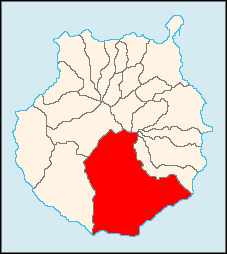
| Map | |
 |
|
| Statistics | |
| Autonomous region: | Canary Islands Canary Islands The Canary Islands , also known as the Canaries , is a Spanish archipelago located just off the northwest coast of mainland Africa, 100 km west of the border between Morocco and the Western Sahara. The Canaries are a Spanish autonomous community and an outermost region of the European Union... |
| Province: | Las Palmas Las Palmas (province) The Province of Las Palmas is a province of Spain, consisting of the eastern part of the autonomous community of the Canary Islands.-Composition:... |
| Island: | Gran Canaria Gran Canaria Gran Canaria is the second most populous island of the Canary Islands, with a population of 838,397 which constitutes approximately 40% of the population of the archipelago... |
| Area Area Area is a quantity that expresses the extent of a two-dimensional surface or shape in the plane. Area can be understood as the amount of material with a given thickness that would be necessary to fashion a model of the shape, or the amount of paint necessary to cover the surface with a single coat... : |
333.13 km² some reads 334.05 km² |
| Population Population A population is all the organisms that both belong to the same group or species and live in the same geographical area. The area that is used to define a sexual population is such that inter-breeding is possible between any pair within the area and more probable than cross-breeding with individuals... : |
44,155 (2001) |
| Population density Population density Population density is a measurement of population per unit area or unit volume. It is frequently applied to living organisms, and particularly to humans... : |
132.18/km² |
| Elevation Elevation The elevation of a geographic location is its height above a fixed reference point, most commonly a reference geoid, a mathematical model of the Earth's sea level as an equipotential gravitational surface .... : Lowest: Centre: Highest: |
Atlantic Ocean Atlantic Ocean The Atlantic Ocean is the second-largest of the world's oceanic divisions. With a total area of about , it covers approximately 20% of the Earth's surface and about 26% of its water surface area... 1,900 m north of town |
| Location Geographic coordinate system A geographic coordinate system is a coordinate system that enables every location on the Earth to be specified by a set of numbers. The coordinates are often chosen such that one of the numbers represent vertical position, and two or three of the numbers represent horizontal position... : |
27.91667/27°55' N lat. 15.55/15°33' W long. |
| Municipal code: | E-35019 |
| Car designation: | GC |
San Bartolomé de Tirajana (first part Spanish
Spanish language
Spanish , also known as Castilian , is a Romance language in the Ibero-Romance group that evolved from several languages and dialects in central-northern Iberia around the 9th century and gradually spread with the expansion of the Kingdom of Castile into central and southern Iberia during the...
meaning Saint Bartholomew) is a Canarian municipality in the southeastern portion of the island of Gran Canaria
Gran Canaria
Gran Canaria is the second most populous island of the Canary Islands, with a population of 838,397 which constitutes approximately 40% of the population of the archipelago...
in the Las Palmas
Las Palmas (province)
The Province of Las Palmas is a province of Spain, consisting of the eastern part of the autonomous community of the Canary Islands.-Composition:...
province in the Canary Islands
Canary Islands
The Canary Islands , also known as the Canaries , is a Spanish archipelago located just off the northwest coast of mainland Africa, 100 km west of the border between Morocco and the Western Sahara. The Canaries are a Spanish autonomous community and an outermost region of the European Union...
. San Bartolomé de Tirajana is the largest municipality in area on the island as well as the Canary Islands
Canary Islands
The Canary Islands , also known as the Canaries , is a Spanish archipelago located just off the northwest coast of mainland Africa, 100 km west of the border between Morocco and the Western Sahara. The Canaries are a Spanish autonomous community and an outermost region of the European Union...
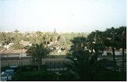
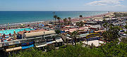
almost covering between a quarter and one-third of the whole island of Gran Canaria and more than 5 to 6% of the archipelago. The capital is situated in "La Caldera de Las Tirajanas". The population is 45,559 (ISTAC, 2003), its density is 136.76/km² and the area is 333.13 km². The elevation is about 600 m. Much of the population live within the Atlantic coastline. San Bartolomé de Tirajana is situated in the mountains and the valley area that is mainly covered with greens and forests. Barren land dominates the north, especially in the mountain areas, while farmlands and urban areas and the Atlantic Ocean lie to the south. San Bartolomé de Tirajana is located S of Las Palmas de Gran Canaria, SSW Telde and NE of Puerto Rico and is accessed with the GC1
GC1 (Gran Canaria)
The GC1 is a superhighway on the island of Gran Canaria. It links the capital Las Palmas in the north with Puerto Rico in the south. It is the fastest route from the top of the island to the bottom and vice versa with a top speed limit of 120 km/h...
superhighway. The main industries are business, agriculture and tourism. San Bartolomé de Tirajana is part of the tourist area of the southern part of the island.
Geography
- Location:
- Latitude: 27.85 (27°51') N
- Longitude: 15.65 (15°33') W
- Altitude:
- Lowest: Atlantic Ocean
- Centre: 1,900 m
- Highest: northern part
- Name of inhabitants: -
- Postal code: - 35100
Historical population
| Year | Population | Density |
|---|---|---|
| 1991 | 24,451 | - |
| 1996 | 35,443 | - |
| 2001 | 34,515 | 103.64/km² |
| 2002 | 43,403 | - |
| 2003 | 45,559 | 136.76/km² |
| 2004 | 44,115 | 132.18/km² |
Communities
- Aldea Blanca
- Castillo del Romeral
- Cercados de Espino
- Cercados de Araña
- MaspalomasMaspalomasMaspalomasCountry:Autonomous Community:Province: Las PalmasIsland: Gran CanariaMunicipality: San Bartolomé de TirajanaPopulation:33,000 Coordinates:Time zone:CET, UTC+1Elevation:5 amslPostal code:35290Map...
- Playa del InglésPlaya del InglésPlaya del Inglés is a sea resort in the south coast of the island of Gran Canaria. It is a zone part of Maspalomas, in the municipality of San Bartolomé de Tirajana, and is a popular tourist attraction, particularly among the gay community in Northern Europe.-Overview:It has a long beach made of...
- San AgustínSan Agustin, Las PalmasSan Agustin is a sea resort in the south coast of the island of Gran Canaria. It is a zone part of Maspalomas, in the municipality of San Bartolomé de Tirajana.-Overview:...
- Playa del Inglés
- San Bartolomé de Tirajana (Tunte)
- Santa Águeda
- El Tablero
Subdivisions
- Ayacata
- Ayagaures
- La Plata
- El Sequero Bajo
- La Culata
- Riscos Blancos
- Lomito de Taidía
- Taidía Alto
- Taidía
- Los Moriscos
- Agualatente
- La Montaña Alta
- La Montaña Baja
- Hoya Grande
- Perera
- El Trejo
- Ciudad de Lima
- Casas Blancas
- Sitios de Arriba
- Sitios de Abajo
- Artedara
- FatagaFatagaFataga is a village in the municipality of San Bartolomé de Tirajana on the island of Gran Canaria . Latitude 27°53'15"N, longitude 15°33'50"W...
- Guriete
- El Sao
- Las Crucitas
- El Matorral
- Juan Grande
Climate
It is located on the leeward portion of the island. Humid winds cover the northeast in the summer months. Precipitation is lower than the northern part of the island and temperatures are slightly higher than the north all year round.Other
San Bartolomé de Tirajana has schools, lyceums, a few gymnasia, churches, a post office and squares (plaza).External links
- Map and aerial photos
- Street map from Mapquest, MapPoint or Google or Yahoo! Maps
- Google or Microsoft Virtual Earth - image now available
- Coordinates: 27°56′0"N 15°33′0"W
See also
| Northwest: Tejeda | North: Vega de San Mateo Vega de San Mateo, Las Palmas Vega de San Mateo Vega de San Mateo Vega de San Mateo (latter part Spanish meaning Saint Matthew is a Canarian municipality in the eastern portion of the island of Gran Canaria in the Las Palmas province in the Canary Islands. The population is 7,617 , its density is 199.66/km² and the area... and Valsequillo |
Northeast: Agüimes Agüimes, Las Palmas Agüimes is a Canarian municipality in the eastern portion of the island of Gran Canaria in the Las Palmas province in the Canary Islands. The population is 23,572 , its density is 297.33/km² and the area is 79.28 km². The elevation is 275 m. Agüimes is situated between the mountains and the... |
| West: Mogán Mogán, Las Palmas Mogán is a municipality in the southwestern corner of the island of Gran Canaria, which is one of the three main islands making up the Spanish province of Las Palmas in the Canary Islands. It includes the fishing towns of Puerto de Mogán and Arguineguin. Mogán is the second largest municipality by... |
San Bartolomé de Tirajana | East: Santa Lucía de Tirajana Santa Lucía de Tirajana Santa Lucía de Tirajana is a Canarian municipality in the southeastern portion of the island of Gran Canaria in the Las Palmas province in the Canary Islands. The population is 53,820 , its density is 882.58/km² and the area is 61.56 km²... |
| South: Atlantic Ocean Atlantic Ocean The Atlantic Ocean is the second-largest of the world's oceanic divisions. With a total area of about , it covers approximately 20% of the Earth's surface and about 26% of its water surface area... |
Southeast: Atlantic Ocean |