

Firgas, Las Palmas
Encyclopedia
| Municipality of Firgas | |
| Map | |
|---|---|
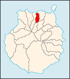 |
|
| Statistics | |
| Autonomous region: | Canary Islands Canary Islands The Canary Islands , also known as the Canaries , is a Spanish archipelago located just off the northwest coast of mainland Africa, 100 km west of the border between Morocco and the Western Sahara. The Canaries are a Spanish autonomous community and an outermost region of the European Union... |
| Province: | Las Palmas Las Palmas (province) The Province of Las Palmas is a province of Spain, consisting of the eastern part of the autonomous community of the Canary Islands.-Composition:... |
| Island: | Gran Canaria Gran Canaria Gran Canaria is the second most populous island of the Canary Islands, with a population of 838,397 which constitutes approximately 40% of the population of the archipelago... |
| Area Area Area is a quantity that expresses the extent of a two-dimensional surface or shape in the plane. Area can be understood as the amount of material with a given thickness that would be necessary to fashion a model of the shape, or the amount of paint necessary to cover the surface with a single coat... : |
15.33 km² some reads 14.72 km² |
| Population Population A population is all the organisms that both belong to the same group or species and live in the same geographical area. The area that is used to define a sexual population is such that inter-breeding is possible between any pair within the area and more probable than cross-breeding with individuals... : |
7,825 (2004) |
| Population density Population density Population density is a measurement of population per unit area or unit volume. It is frequently applied to living organisms, and particularly to humans... : |
246.53/km² |
| Elevation Elevation The elevation of a geographic location is its height above a fixed reference point, most commonly a reference geoid, a mathematical model of the Earth's sea level as an equipotential gravitational surface .... : Lowest: Centre: Highest: |
Atlantic Ocean Atlantic Ocean The Atlantic Ocean is the second-largest of the world's oceanic divisions. With a total area of about , it covers approximately 20% of the Earth's surface and about 26% of its water surface area... 485 m southern part |
| Location Geographic coordinate system A geographic coordinate system is a coordinate system that enables every location on the Earth to be specified by a set of numbers. The coordinates are often chosen such that one of the numbers represent vertical position, and two or three of the numbers represent horizontal position... : |
28.1/28°6' N lat. 15.55/15°35' W long. |
| Municipal code: | E-35008 |
| Car designation: | GC until 2001 |
Firgas is a Canary Islands
Canary Islands
The Canary Islands , also known as the Canaries , is a Spanish archipelago located just off the northwest coast of mainland Africa, 100 km west of the border between Morocco and the Western Sahara. The Canaries are a Spanish autonomous community and an outermost region of the European Union...
municipality in the province of Las Palmas
Las Palmas (province)
The Province of Las Palmas is a province of Spain, consisting of the eastern part of the autonomous community of the Canary Islands.-Composition:...
. Is a suburb of Las Palmas
Las Palmas de Gran Canaria
Las Palmas de Gran Canaria commonly known as Las Palmas is the political capital, jointly with Santa Cruz, the most populous city in the Autonomous Community of the Canary Islands and the ninth largest city in Spain, with a population of 383,308 in 2010. Nearly half of the people of the island...
city. It is situated in the north of Gran Canaria
Gran Canaria
Gran Canaria is the second most populous island of the Canary Islands, with a population of 838,397 which constitutes approximately 40% of the population of the archipelago...
. It has an area of 15.77 km², 7,023 inhabitants (ISTAC, 2003) and the density of 455.34/km². It celebrated its 500th anniversary in 1988. The town was founded in 1488.
Geography
- Location:
- Latitude: 28.1 (28°6") N
- Longitude: 15.55 (15°33') W
- Altitude:
- Lowest: northern part, about 50 m
- Centre: 485 m
- Highest: southern part
- Name of inhabitants: -
- Postal code: -
Historical population
| Year | Population | Density |
|---|---|---|
| 1991 | 5,735 | - |
| 1996 | 6,526 | - |
| 2001 | 6,865 | 429.06/km² |
| 2002 | 6,927 | - |
| 2003 | 7,023 | 455.34/km² |
| 2004 | 7,060 | 479.62/km² |
Location
Tenerife
Tenerife is the largest and most populous island of the seven Canary Islands, it is also the most populated island of Spain, with a land area of 2,034.38 km² and 906,854 inhabitants, 43% of the total population of the Canary Islands. About five million tourists visit Tenerife each year, the...
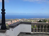
. It is one of the seven towns in Gran Canaria that has no beach, although it is only a few minutes from the coast by car, and 20 minutes drive from the capital. The water might be the best known feature of the island, which has a plant that bottles "Firgas water".

The town
The central square, which has a church and town hall, is called San Roque. Important attractions are the different squares, and the Paseo the Gran Canaria, where a 30 meter high waterfallWaterfall
A waterfall is a place where flowing water rapidly drops in elevation as it flows over a steep region or a cliff.-Formation:Waterfalls are commonly formed when a river is young. At these times the channel is often narrow and deep. When the river courses over resistant bedrock, erosion happens...
has been laid out, as well as relief models of the different islands.
Other
Firgas has schools, a few lyceums and gymnasia, churches, a post office and a few squares (plazas).External links
- www.firgas.es/
- Map and aerial photos
- Street map: Street map from Mapquest, MapPoint, Google or Yahoo! Maps
- Satellite images: Google or Microsoft Virtual Earth - image now available
- Coordinates: 28°6′0"N 15°33′0"W
See also
- Grand Canary
- List of municipalities in Las Palmas
| North: Moya and Arucas | ||
| West: Moya Moya, Las Palmas Moya is a municipality of Las Palmas province, on the Canary Islands. It is in the northern part of the Grand Canary island or Gran Canaria.Moya's area is 31.87 km² with a population of about 8,307 and its density is 250.63/km².... |
Firgas | East: Arucas Arucas, Las Palmas Arucas is a Canary Islands municipality in the province of Las Palmas. It is situated in the north of Gran Canaria. Arucas is a suburb of Las Palmas city.... |
| South: Valleseco Valleseco, Las Palmas Valleseco is a municipality of Las Palmas province, on the Canary Islands. It is in the northcentral part of Gran Canaria. Valleseco means "dry valley" in Spanish, but its name is misleading, since it is actually one of the wettest municipalities of the island.... |
Southeast: Teror Teror Teror is a Canarian municipality in the northern portion of the island of Gran Canaria in the Las Palmas province in the Canary Islands. Teror is a suburb of Las Palmas city... |