

La Aldea de San Nicolás
Encyclopedia
| La Aldea de San Nicolás | |
| Map | |
|---|---|
 |
|
| Statistics | |
| Autonomous region: | Canary Islands Canary Islands The Canary Islands , also known as the Canaries , is a Spanish archipelago located just off the northwest coast of mainland Africa, 100 km west of the border between Morocco and the Western Sahara. The Canaries are a Spanish autonomous community and an outermost region of the European Union... |
| Province: | Las Palmas Las Palmas (province) The Province of Las Palmas is a province of Spain, consisting of the eastern part of the autonomous community of the Canary Islands.-Composition:... |
| Island: | Gran Canaria Gran Canaria Gran Canaria is the second most populous island of the Canary Islands, with a population of 838,397 which constitutes approximately 40% of the population of the archipelago... |
| Area Area Area is a quantity that expresses the extent of a two-dimensional surface or shape in the plane. Area can be understood as the amount of material with a given thickness that would be necessary to fashion a model of the shape, or the amount of paint necessary to cover the surface with a single coat... : |
123.58 km² |
| Population Population A population is all the organisms that both belong to the same group or species and live in the same geographical area. The area that is used to define a sexual population is such that inter-breeding is possible between any pair within the area and more probable than cross-breeding with individuals... : |
8,539 (2009) |
| Population density Population density Population density is a measurement of population per unit area or unit volume. It is frequently applied to living organisms, and particularly to humans... : |
65.76/km² |
| Elevation Elevation The elevation of a geographic location is its height above a fixed reference point, most commonly a reference geoid, a mathematical model of the Earth's sea level as an equipotential gravitational surface .... : Lowest: Centre: Highest: |
Atlantic Ocean Atlantic Ocean The Atlantic Ocean is the second-largest of the world's oceanic divisions. With a total area of about , it covers approximately 20% of the Earth's surface and about 26% of its water surface area... 33 m Inagua Mountain, 1.405 m |
| Location Geographic coordinate system A geographic coordinate system is a coordinate system that enables every location on the Earth to be specified by a set of numbers. The coordinates are often chosen such that one of the numbers represent vertical position, and two or three of the numbers represent horizontal position... : |
27.9/27°54' N lat. 15.95/15°57' W long. |
| Website: | www.laaldeadesannicolas.es |
La Aldea de San Nicolás or San Nicolás de Tolentino (in English
English language
English is a West Germanic language that arose in the Anglo-Saxon kingdoms of England and spread into what was to become south-east Scotland under the influence of the Anglian medieval kingdom of Northumbria...
Saint Nicholas of Tolentino) is a Canarian municipality in the western portion of the island of Gran Canaria
Gran Canaria
Gran Canaria is the second most populous island of the Canary Islands, with a population of 838,397 which constitutes approximately 40% of the population of the archipelago...
in the Las Palmas
Las Palmas (province)
The Province of Las Palmas is a province of Spain, consisting of the eastern part of the autonomous community of the Canary Islands.-Composition:...
province in the Canary Islands
Canary Islands
The Canary Islands , also known as the Canaries , is a Spanish archipelago located just off the northwest coast of mainland Africa, 100 km west of the border between Morocco and the Western Sahara. The Canaries are a Spanish autonomous community and an outermost region of the European Union...
and is the westernmost municipality in the province. The municipality is also called La Aldea de San Nicolás de Tolentino while the locals simply called La Aldea.
The population
Population
A population is all the organisms that both belong to the same group or species and live in the same geographical area. The area that is used to define a sexual population is such that inter-breeding is possible between any pair within the area and more probable than cross-breeding with individuals...
is 8,089 (ISTAC, 2003), its density is 65.76/km² and the area is 123.58 km². The elevation is about 33 m. Much of the population live within the Atlantic coastline.
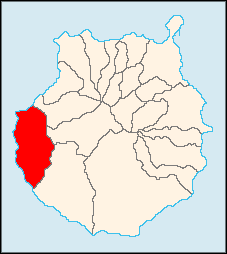
San Nicolás de Tolentino is situated in the mountains and the valley area that are mainly covered with greens and forests. Barren land dominates the mountaintops. The mountains cover much of the municipality except where farmlands and small valleys lie to the south and also the Atlantic Ocean is to the south. San Nicolás de Tolentino is located SW of Las Palmas de Gran Canaria, W Teide and NW of Puerto Rico and SW of Arucas
Arucas, Las Palmas
Arucas is a Canary Islands municipality in the province of Las Palmas. It is situated in the north of Gran Canaria. Arucas is a suburb of Las Palmas city....
and is accessed with the major highway linking Las Palmas de Gran Canaria and Puerto Rico de Gran Canaria as well as a coastal road and north to Arucas. The main industry are business, agriculture, tourism (less common than the south). The infrastructure in San Nicolás is not much common as in the southern part. San Nicolás de Tolentino is north of the tourist area of the southern part of the island. Its streets are narrow and small and some of them are impassable. The roads are not narrow and are without guardrails and partially passed by two cars next to each other on the roads.
The town is famous for its tomato plants, and the majority of its population is reliant on the trade. The water is supplied to its farms from numerous artificial lakes in the mountains and comes from rainfalls during the winter months. These artificial lakes are privately-built and the irrigation costs.
Other than tomatoes features other agricultural products including potatoes and other fruits and vegetables.
Geography
- Location:
- Latitude: 27.9 (27°54') N
- Longitude: 15.95 (15°57') W
- Altitude:
- Lowest: Atlantic Ocean
- Centre: 33 m
- Highest: northern part
- Name of inhabitants: -
- Postal code: -
Zip Code: 35470
Historical population
| Year | Population | Density |
|---|---|---|
| 1991 | 7,751 | - |
| 1996 | 8,082 | - |
| 2001 | 7,668 | 61.83/km² |
| 2002 | 8,063 | - |
| 2003 | 8,089 | 65.76/km² |
| 2004 | 7,988 | 64.71/km² |
Famous people
- Román Rodríguez RodríguezRomán Rodríguez RodríguezRomán Rodríguez Rodríguez is a Canarian politician who was the president of the Canary Islands between 1999 and 2003. He was licensed in medicine at the University of La Laguna. He worked as a medical assistant for one year and as a university professor.During the 1980s, he took part in...
(b. March 1, 1956) a Canarian politician and a former President of the Canary Islands from 1999 to 2003.
Other
San Nicolás de Tolentino has schools, lyceums, a few gymnasia, churches, a post office and squares (plaza).External links
See also
| North: Atlantic Ocean Atlantic Ocean The Atlantic Ocean is the second-largest of the world's oceanic divisions. With a total area of about , it covers approximately 20% of the Earth's surface and about 26% of its water surface area... and Artenara Artenara, Las Palmas Artenara is a Canarian municipality in the west/central and the central portion of the island of Gran Canaria in the Las Palmas province in the Canary Islands. The population is 1,357 , its density is 20.34/km² and the area is 66.7 km²... |
Northeast: Artenara Artenara, Las Palmas Artenara is a Canarian municipality in the west/central and the central portion of the island of Gran Canaria in the Las Palmas province in the Canary Islands. The population is 1,357 , its density is 20.34/km² and the area is 66.7 km²... |
|
| West: Atlantic Ocean Atlantic Ocean The Atlantic Ocean is the second-largest of the world's oceanic divisions. With a total area of about , it covers approximately 20% of the Earth's surface and about 26% of its water surface area... |
San Nicolás de Tolentino | East: Tejeda |
| South: Mogán Mogán, Las Palmas Mogán is a municipality in the southwestern corner of the island of Gran Canaria, which is one of the three main islands making up the Spanish province of Las Palmas in the Canary Islands. It includes the fishing towns of Puerto de Mogán and Arguineguin. Mogán is the second largest municipality by... and the Atlantic Ocean Atlantic Ocean The Atlantic Ocean is the second-largest of the world's oceanic divisions. With a total area of about , it covers approximately 20% of the Earth's surface and about 26% of its water surface area... |
Southeast: Mogán Mogán, Las Palmas Mogán is a municipality in the southwestern corner of the island of Gran Canaria, which is one of the three main islands making up the Spanish province of Las Palmas in the Canary Islands. It includes the fishing towns of Puerto de Mogán and Arguineguin. Mogán is the second largest municipality by... |