

Geology of Nepal
Encyclopedia
Himalayas
The Himalaya Range or Himalaya Mountains Sanskrit: Devanagari: हिमालय, literally "abode of snow"), usually called the Himalayas or Himalaya for short, is a mountain range in Asia, separating the Indian subcontinent from the Tibetan Plateau...
arc extends about 2400 km from Nanga Parbat
Nanga Parbat
Nanga Parbat is the ninth highest mountain on Earth, the second highest mountain in Pakistan and among the eight-thousanders with a summit elevation of 8,126 meters...
(8,138 m) by the Indus River
Indus River
The Indus River is a major river which flows through Pakistan. It also has courses through China and India.Originating in the Tibetan plateau of western China in the vicinity of Lake Mansarovar in Tibet Autonomous Region, the river runs a course through the Ladakh district of Jammu and Kashmir and...
in northern Pakistan
Pakistan
Pakistan , officially the Islamic Republic of Pakistan is a sovereign state in South Asia. It has a coastline along the Arabian Sea and the Gulf of Oman in the south and is bordered by Afghanistan and Iran in the west, India in the east and China in the far northeast. In the north, Tajikistan...
eastward to Namche Barwa (7,756 m) by the gorge of the Tsangpo
Yarlung Zangbo River
Yarlung River is a watercourse that originates upstream from the South Tibet Valley and Yarlung Zangbo Grand Canyon, in Tibet. It then passes through the state of Arunachal Pradesh, India, where it is known as the Dihang....
-Brahmaputra
Brahmaputra River
The Brahmaputra , also called Tsangpo-Brahmaputra, is a trans-boundary river and one of the major rivers of Asia. It is the only Indian river that is attributed the masculine gender and thus referred to as a in Indo-Aryan languages and languages with Indo-Aryan influence...
in eastern Tibet
Tibet
Tibet is a plateau region in Asia, north-east of the Himalayas. It is the traditional homeland of the Tibetan people as well as some other ethnic groups such as Monpas, Qiang, and Lhobas, and is now also inhabited by considerable numbers of Han and Hui people...
. About 800 km of this extent is in Nepal
Nepal
Nepal , officially the Federal Democratic Republic of Nepal, is a landlocked sovereign state located in South Asia. It is located in the Himalayas and bordered to the north by the People's Republic of China, and to the south, east, and west by the Republic of India...
; the remainder includes Bhutan
Bhutan
Bhutan , officially the Kingdom of Bhutan, is a landlocked state in South Asia, located at the eastern end of the Himalayas and bordered to the south, east and west by the Republic of India and to the north by the People's Republic of China...
and parts of Pakistan
Pakistan
Pakistan , officially the Islamic Republic of Pakistan is a sovereign state in South Asia. It has a coastline along the Arabian Sea and the Gulf of Oman in the south and is bordered by Afghanistan and Iran in the west, India in the east and China in the far northeast. In the north, Tajikistan...
, India
India
India , officially the Republic of India , is a country in South Asia. It is the seventh-largest country by geographical area, the second-most populous country with over 1.2 billion people, and the most populous democracy in the world...
, and China
China
Chinese civilization may refer to:* China for more general discussion of the country.* Chinese culture* Greater China, the transnational community of ethnic Chinese.* History of China* Sinosphere, the area historically affected by Chinese culture...
. Since 55 Ma
Anum
Anum is an Akan town in the Asuogyaman District of Eastern Ghana, across from the Volta Lake.an...
the Himalayan orogeny
Orogeny
Orogeny refers to forces and events leading to a severe structural deformation of the Earth's crust due to the engagement of tectonic plates. Response to such engagement results in the formation of long tracts of highly deformed rock called orogens or orogenic belts...
beginning with the collision of Indian subcontinent
Indian subcontinent
The Indian subcontinent, also Indian Subcontinent, Indo-Pak Subcontinent or South Asian Subcontinent is a region of the Asian continent on the Indian tectonic plate from the Hindu Kush or Hindu Koh, Himalayas and including the Kuen Lun and Karakoram ranges, forming a land mass which extends...
and Eurasia
Eurasia
Eurasia is a continent or supercontinent comprising the traditional continents of Europe and Asia ; covering about 52,990,000 km2 or about 10.6% of the Earth's surface located primarily in the eastern and northern hemispheres...
at the Paleocene
Paleocene
The Paleocene or Palaeocene, the "early recent", is a geologic epoch that lasted from about . It is the first epoch of the Palaeogene Period in the modern Cenozoic Era...
/Eocene
Eocene
The Eocene Epoch, lasting from about 56 to 34 million years ago , is a major division of the geologic timescale and the second epoch of the Paleogene Period in the Cenozoic Era. The Eocene spans the time from the end of the Palaeocene Epoch to the beginning of the Oligocene Epoch. The start of the...
epoch, has thickened the Indian crust
Crust (geology)
In geology, the crust is the outermost solid shell of a rocky planet or natural satellite, which is chemically distinct from the underlying mantle...
to its present thickness of 70 km. The northwest tip of India after colliding with Asia seems to have met along the full length of the suture
Suture (geology)
In structural geology, a suture is a major fault zone through an orogen or mountain range. Sutures separate terranes, tectonic units that have different plate tectonic, metamorphic and paleogeographic histories...
by about 40 Ma. Immediately prior to the onset of the Indo—Asian collision, the northern boundary of the Indian shield was likely a thinned continental margin
Continental margin
The continental margin is the zone of the ocean floor that separates the thin oceanic crust from thick continental crust. Continental margins constitute about 28% of the oceanic area....
on which Proterozoic
Proterozoic
The Proterozoic is a geological eon representing a period before the first abundant complex life on Earth. The name Proterozoic comes from the Greek "earlier life"...
clastic sediments and the Cambrian
Cambrian
The Cambrian is the first geological period of the Paleozoic Era, lasting from Mya ; it is succeeded by the Ordovician. Its subdivisions, and indeed its base, are somewhat in flux. The period was established by Adam Sedgwick, who named it after Cambria, the Latin name for Wales, where Britain's...
±Eocene
Eocene
The Eocene Epoch, lasting from about 56 to 34 million years ago , is a major division of the geologic timescale and the second epoch of the Paleogene Period in the Cenozoic Era. The Eocene spans the time from the end of the Palaeocene Epoch to the beginning of the Oligocene Epoch. The start of the...
Tethyan
Tethys Ocean
The Tethys Ocean was an ocean that existed between the continents of Gondwana and Laurasia during the Mesozoic era before the opening of the Indian Ocean.-Modern theory:...
shelf sequence were deposited.
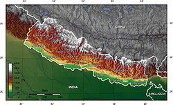
Tectonostratigraphic division of Nepal Himalaya
, and divided the rocks of the Himalaya into four tectonostratigraphicTectonostratigraphy
In geology, tectonostratigraphy refers either to rock sequences in which large-scale layering is caused by the stacking of thrust sheets or nappes in areas of thrust tectonics or the effects of tectonics on lithostratigraphy.-Tectonically formed stratigraphy:...
zones that are characterised by distinctive stratigraphy
Stratigraphy
Stratigraphy, a branch of geology, studies rock layers and layering . It is primarily used in the study of sedimentary and layered volcanic rocks....
and physiography. From north to south, these are the Sub Himalayan, Lesser Himalayan, Greater Himalayan, and Tibetan Himalayan zones.
Terai
The TeraiTerai
The Terai is a belt of marshy grasslands, savannas, and forests located south of the outer foothills of the Himalaya, the Siwalik Hills, and north of the Indo-Gangetic Plain of the Ganges, Brahmaputra and their tributaries. The Terai belongs to the Terai-Duar savanna and grasslands ecoregion...
is a rich, fertile and ancient land in the southern part of Nepal. In Nepal
Nepal
Nepal , officially the Federal Democratic Republic of Nepal, is a landlocked sovereign state located in South Asia. It is located in the Himalayas and bordered to the north by the People's Republic of China, and to the south, east, and west by the Republic of India...
it is the Nepalese extension of the Indo-Gangetic Plain
Indo-Gangetic plain
The northern Plains also known as the Indo - Gangetic Plain and The North Indian River Plain is a large and fertile plain encompassing most of northern and eastern India, the most populous parts of Pakistan, parts of southern Nepal and virtually all of Bangladesh...
s, which covers most of northern and eastern India, the most populous parts of Pakistan, and virtually all of Bangladesh. The Plains get their names from the rivers Ganges and Indus.
The vast alluvial plain
Alluvial plain
An alluvial plain is a relatively flat landform created by the deposition of sediment over a long period of time by one or more rivers coming from highland regions, from which alluvial soil forms...
s of the Indo-Gangetic Basin evolved as a foreland basin
Foreland basin
A foreland basin is a depression that develops adjacent and parallel to a mountain belt. Foreland basins form because the immense mass created by crustal thickening associated with the evolution of a mountain belt causes the lithosphere to bend, by a process known as lithospheric flexure...
in the southern part of the rising Himalaya, before breaking up along a series of steep faults known as the Himalayan Frontal Fault or the Main Frontal Thrust . It comprises several sub-basins and all of them are quite shallow towards the south, but rather deep in the northern sections.
Sub-Himalaya (Siwaliks)
The Sub-Himalayan Sequence borders the Indo-Gangetic Floodplain along the Himalayan Frontal Fault and is dominated by thick Late Tertiary mollassicMolasse
The term "molasse" refers to the sandstones, shales and conglomerates formed as terrestrial or shallow marine deposits in front of rising mountain chains. The molasse is deposited in a foreland basin, especially on top of flysch, for example that left from the rising Alps, or erosion in the Himalaya...
deposits known as the Siwaliks that resulted from the accumulating fluvial
Fluvial
Fluvial is used in geography and Earth science to refer to the processes associated with rivers and streams and the deposits and landforms created by them...
deposits on the southern front of the evolving Himalaya. In Nepal, it extends throughout the country from east to west in the southern part. It is delineated by the Himalayan Frontal Thrust (HFT) and Main Boundary Thrust (MBT) in south and north respectively. The youngest sediments on the top are the conglomerates
Conglomerate (geology)
A conglomerate is a rock consisting of individual clasts within a finer-grained matrix that have become cemented together. Conglomerates are sedimentary rocks consisting of rounded fragments and are thus differentiated from breccias, which consist of angular clasts...
, and the sandstone
Sandstone
Sandstone is a sedimentary rock composed mainly of sand-sized minerals or rock grains.Most sandstone is composed of quartz and/or feldspar because these are the most common minerals in the Earth's crust. Like sand, sandstone may be any colour, but the most common colours are tan, brown, yellow,...
s and mudstone
Mudstone
Mudstone is a fine grained sedimentary rock whose original constituents were clays or muds. Grain size is up to 0.0625 mm with individual grains too small to be distinguished without a microscope. With increased pressure over time the platey clay minerals may become aligned, with the...
s are dominant in the lower portions. The upward coarsening sequence of the sediments obviously exhibit the time-history in the evolution and growth of the Himalaya during the early Tertiary
Tertiary
The Tertiary is a deprecated term for a geologic period 65 million to 2.6 million years ago. The Tertiary covered the time span between the superseded Secondary period and the Quaternary...
time .
The Sub Himalayan zone is the 10 to 25 km wide belt of Neogene Siwaliks (or Churia) group rocks forming the topographic front of the Himalaya. It rises from the fluvial
Fluvial
Fluvial is used in geography and Earth science to refer to the processes associated with rivers and streams and the deposits and landforms created by them...
plains of the active foreland basin, and this front generally mapped as the trace of the Main Frontal Thrust (MFT). The Siwaliks Group consists of upward-coarsening successions of fluvial mudstone, siltstone
Siltstone
Siltstone is a sedimentary rock which has a grain size in the silt range, finer than sandstone and coarser than claystones.- Description :As its name implies, it is primarily composed of silt sized particles, defined as grains 1/16 - 1/256 mm or 4 to 8 on the Krumbein phi scale...
, sandstone, and conglomerate. The Siwaliks Group in Nepal is composed of three units that are known as lower, middle and upper members. These units can be correlated with the Sub Himalaya of Pakistan and of northern India . Palaeocurrent and petrographic
Petrography
Petrography is a branch of petrology that focuses on detailed descriptions of rocks. Someone who studies petrography is called a petrographer. The mineral content and the textural relationships within the rock are described in detail. Petrographic descriptions start with the field notes at the...
data from the sandstone and conglomerate indicate that these rocks were derived from the fold-thrust belt, and deposited within the flexural foredeep of the Himalayan foreland basin .
Lesser Himalaya
The Lesser Himalayas lies in between the Sub-Himalayas and Higher Himalayas separated by the Main Boundary Thrust (MBT) and the Main Central Thrust (MCT) respectively. The total width ranges from 60–80 km. The Lesser Himalayas is made up mostly of the unfossiliferous sedimentary and metasedimentary rocks; such as shaleShale
Shale is a fine-grained, clastic sedimentary rock composed of mud that is a mix of flakes of clay minerals and tiny fragments of other minerals, especially quartz and calcite. The ratio of clay to other minerals is variable. Shale is characterized by breaks along thin laminae or parallel layering...
, sandstone, conglomerate, slate
Slate
Slate is a fine-grained, foliated, homogeneous metamorphic rock derived from an original shale-type sedimentary rock composed of clay or volcanic ash through low-grade regional metamorphism. The result is a foliated rock in which the foliation may not correspond to the original sedimentary layering...
, phyllite
Phyllite
Phyllite is a type of foliated metamorphic rock primarily composed of quartz, sericite mica, and chlorite; the rock represents a gradation in the degree of metamorphism between slate and mica schist. Minute crystals of graphite, sericite, or chlorite impart a silky, sometimes golden sheen to the...
, schist
Schist
The schists constitute a group of medium-grade metamorphic rocks, chiefly notable for the preponderance of lamellar minerals such as micas, chlorite, talc, hornblende, graphite, and others. Quartz often occurs in drawn-out grains to such an extent that a particular form called quartz schist is...
, quartzite
Quartzite
Quartzite is a hard metamorphic rock which was originally sandstone. Sandstone is converted into quartzite through heating and pressure usually related to tectonic compression within orogenic belts. Pure quartzite is usually white to gray, though quartzites often occur in various shades of pink...
, limestone
Limestone
Limestone is a sedimentary rock composed largely of the minerals calcite and aragonite, which are different crystal forms of calcium carbonate . Many limestones are composed from skeletal fragments of marine organisms such as coral or foraminifera....
and dolomite
Dolomite
Dolomite is a carbonate mineral composed of calcium magnesium carbonate CaMg2. The term is also used to describe the sedimentary carbonate rock dolostone....
. The rocks range in age from Precambrian
Precambrian
The Precambrian is the name which describes the large span of time in Earth's history before the current Phanerozoic Eon, and is a Supereon divided into several eons of the geologic time scale...
to Miocene
Miocene
The Miocene is a geological epoch of the Neogene Period and extends from about . The Miocene was named by Sir Charles Lyell. Its name comes from the Greek words and and means "less recent" because it has 18% fewer modern sea invertebrates than the Pliocene. The Miocene follows the Oligocene...
. The geology is complicated due to folding
Fold (geology)
The term fold is used in geology when one or a stack of originally flat and planar surfaces, such as sedimentary strata, are bent or curved as a result of permanent deformation. Synsedimentary folds are those due to slumping of sedimentary material before it is lithified. Folds in rocks vary in...
, faulting and thrusting
Thrust fault
A thrust fault is a type of fault, or break in the Earth's crust across which there has been relative movement, in which rocks of lower stratigraphic position are pushed up and over higher strata. They are often recognized because they place older rocks above younger...
and are largely unfossiliferous. Tectonically
Tectonics
Tectonics is a field of study within geology concerned generally with the structures within the lithosphere of the Earth and particularly with the forces and movements that have operated in a region to create these structures.Tectonics is concerned with the orogenies and tectonic development of...
, the entire Lesser Himalayas consists of two sequences of rocks: allochthon
Allochthon
thumb|right|250px|Schematic overview of a thrust system. The hanging wall block is called a [[nappe]]. If an [[erosion]]al hole is created in the nappe that is called a [[window |window]]...
ous, and autochthon
Autochthon
Autochthon , or the anglicized adjective autochthonous or abstract noun autochthony may refer to:* The indigenous peoples of a place...
ous-paraautochthonous units; with various nappe
Nappe
In geology, a nappe is a large sheetlike body of rock that has been moved more than or 5 km from its original position. Nappes form during continental plate collisions, when folds are sheared so much that they fold back over on themselves and break apart. The resulting structure is a...
s, klippe
Klippe
thumb|right|350px|Schematic overview of a thrust system. The shaded material is called a [[nappe]]. The erosional hole is called a [[window |window or fenster]]. The klippe is the isolated block of the nappe overlying autochthonous material....
s and tectonic windows
Window (geology)
thumb|right|350px|Schematic overview of a thrust system. The [[fault |hanging wall block]] is called a [[nappe]]. If an [[erosion]]al hole is created in the nappe that is called a window. A [[klippe]] is a solitary outcrop of the nappe in the middle of autochthonous material.A tectonic window...
.
The northernmost boundary of the Siwaliks Group is marked by the Main Boundary Thrust (MBT), over which the low-grade metasedimentary rocks of the Lesser Himalaya overlie. The Lesser Himalaya, also called the Lower Himalaya, or the Midlands, is a thick (about 7 km) section of para-autochthonous crystalline rocks made up of low- to medium grade rocks. These lower Proterozoic
Proterozoic
The Proterozoic is a geological eon representing a period before the first abundant complex life on Earth. The name Proterozoic comes from the Greek "earlier life"...
clastic rocks are subdivided into two groups. Argillo-arenaceous rocks dominate the lower half of the succession, whereas the upper half consists of both carbonate
Carbonate rock
Carbonate rocks are a class of sedimentary rocks composed primarily of carbonate minerals. The two major types are limestone, which is composed of calcite or aragonite and dolostone, which is composed of the mineral dolomite .Calcite can be either dissolved by groundwater or precipitated by...
and siliciclastic rock
Siliciclastic
Siliciclastic rocks are clastic noncarbonate sedimentary rocks that are almost exclusively silica-bearing, either as forms of quartz or other silicate minerals. All siliciclastic rocks are formed by inorganic processes, or deposited through some mechanical process, such as stream deposits that are...
s . The Lesser Himalaya thrust over the Siwaliks along the MBT to the south, and is overlained by the allochthonous thrust sheets of Kathmandu and HHC along the MCT. The Lesser Himalaya is folded into a vast post-metamorphic anticlinal
Anticline
In structural geology, an anticline is a fold that is convex up and has its oldest beds at its core. The term is not to be confused with antiform, which is a purely descriptive term for any fold that is convex up. Therefore if age relationships In structural geology, an anticline is a fold that is...
structure known as the Kunchha-Gorkha anticlinorium . The southern flank of the anticlinorium is weakly metamorphosed, whereas the northern flank is highly metamorphosed.
Main Central Thrust Zone
The Main Central thrust (MCT) is the single largest structure within the Indian plate that has accommodated Indian-Asian convergence. It extends for nearly 2500 km along strikeStrike and dip
Strike and dip refer to the orientation or attitude of a geologic feature. The strike line of a bed, fault, or other planar feature is a line representing the intersection of that feature with a horizontal plane. On a geologic map, this is represented with a short straight line segment oriented...
and has been the site of at least 140 and perhaps more than 600 km of displacement . defined the MCT in Kumaon based on the difference in metamorphic grade between low to medium-grade rocks of the Lesser Himalaya and higher-grade rocks of the Greater Himalaya. However, the fault originally defined by is not the MCT, but a fault within Lesser Himalaya rocks . This misidentification symbolizes the challenge that workers have faced in locating the MCT. The metamorphic grade within the Lesser Himalaya increases towards the MCT and at higher structural levels.
In central Nepal, the metamorphic grade increases from low (chlorite + biotite) to medium (biotite + garnet + kyanite + staurolite) towards the MCT over a north-south distance. The highest-grade rocks (kyanite and sillimanite gneisses) are found within the MCT shear zone
Shear zone
A shear zone is a very important structural discontinuity surface in the Earth's crust and upper mantle. It forms as a response to inhomogeneous deformation partitioning strain into planar or curviplanar high-strain zones. Intervening blocks stay relatively unaffected by the deformation...
, i.e. upper Lesser Himalaya. places two thrusts (MCT I and MCT II) on each side of the MCT shear zone.
Higher Himalaya
This zone extends from the MCT to Tibetan-Tethys Zone and runs throughout the country. This zone consists of almost 10 km thick succession of the crystalline rocks, commonly called the Himal Group. This sequence can be divided into four main units, as Kyanite-Sillimanite gneissGneiss
Gneiss is a common and widely distributed type of rock formed by high-grade regional metamorphic processes from pre-existing formations that were originally either igneous or sedimentary rocks.-Etymology:...
, pyroxenic
Pyroxene
The pyroxenes are a group of important rock-forming inosilicate minerals found in many igneous and metamorphic rocks. They share a common structure consisting of single chains of silica tetrahedra and they crystallize in the monoclinic and orthorhombic systems...
marble
Marble
Marble is a metamorphic rock composed of recrystallized carbonate minerals, most commonly calcite or dolomite.Geologists use the term "marble" to refer to metamorphosed limestone; however stonemasons use the term more broadly to encompass unmetamorphosed limestone.Marble is commonly used for...
and gneiss, banded gneiss, and augen gneiss in the ascending order .
The Higher Himalayan sequence has been variously named. French workers used the term Dalle du Tibet (Tibetan Slab) for this unit . called them Khumbu Nappes, and Lumbasumba Nappes. calls it the Himalayan Gneiss Group, and it lies above the MCT II, or the upper MCT.
The High Himalayan Crystalline units (HHC) are mainly composed of kyanite- to sillimanite-grade gneisses intruded by High Himalayan leucogranite
Leucogranite
In geology, leucogranites are amongst the youngest intrusions related to anatexis of continental crust anywhere in the world. Leucogranites are commonly found in deformed metapelitic/metagraywacke sequences that have been thrusted over basements during crustal thickening associated with continental...
s at structurally higher levels . Throughout much of the range, the unit is divided into three formations . In central Nepal , the upper Formation III consists of augen orthogneisses, whereas the Middle Formation II are calcsilicate gneisses and marbles, and the basal Formation I are kyanite- and sillimanite bearing metapelite
Pelite
Pelite is old and currently not widely used field terminology for a clayey fine-grained clastic sediment or sedimentary rock, i.e. mud or mudstone. It is equivalent to the Latin-derived term lutite. More commonly, metamorphic geologists currently use pelite for a metamorphosed fine-grained...
s, gneisses, and metagreywacke
Greywacke
Greywacke or Graywacke is a variety of sandstone generally characterized by its hardness, dark color, and poorly sorted angular grains of quartz, feldspar, and small rock fragments or lithic fragments set in a compact, clay-fine matrix. It is a texturally immature sedimentary rock generally found...
s with abundant quartzite
Quartzite
Quartzite is a hard metamorphic rock which was originally sandstone. Sandstone is converted into quartzite through heating and pressure usually related to tectonic compression within orogenic belts. Pure quartzite is usually white to gray, though quartzites often occur in various shades of pink...
.
The gneiss of Higher Himalayan zone (HHZ) is a thick continuous sequence of about 5 to 15 km . The northern part is marked by North Himalayan Normal fault (NHNF), which is also known as the South Tibetan Detachment system (STDS). At its base, it is bounded by the MCT. The protolith
Protolith
Protolith refers to the precursor lithology of a metamorphic rock.For example, the protolith of a slate is a shale or mudstone. Metamorphic rocks can be derived from any other rock and thus have a wide variety of protoliths. Identifying a protolith is a major aim of metamorphic geology.Sedimentary...
of the HHC is interpreted to be Late Proterozoic clastic sedimentary rocks deposited on the northern Indian margin .
Tibetan-Tethys
The Tibetan-Tethys Himalayas generally begins from the top of the Higher Himalayan Zone and extends to the north in TibetTibet
Tibet is a plateau region in Asia, north-east of the Himalayas. It is the traditional homeland of the Tibetan people as well as some other ethnic groups such as Monpas, Qiang, and Lhobas, and is now also inhabited by considerable numbers of Han and Hui people...
. In Nepal these fossiliferous rocks are well developed in Thak Khola (Mustang
Mustang District
Mustang District, a part of Dhawalagiri Zone, is one of the seventy-five districts of Nepal, a landlocked country of South Asia. The district, with Jomsom as its headquarters, covers an area of 3,573 km² and has a population of 14,981....
), Manang
Manang
Manang is a town in the Manang District of Nepal. It is located at 28°40'0N 84°1'0E with an altitude of . At the time of the 1991 Nepal census it had a population of 391 people living in 120 individual households....
and Dolpa area. This zone is about 40 km wide and composed of fossiliferous sedimentary rocks such as shale, sandstone and limestone etc.
The area north of the Annapurna
Annapurna
Annapurna is a section of the Himalayas in north-central Nepal that includes Annapurna I, thirteen additional peaks over and 16 more over ....
and Manaslu
Manaslu
Manaslu , also known as Kutang) is the eighth highest mountain in the world, and is located in the Mansiri Himal, part of the Nepalese Himalayas, in the west-central part of Nepal. Its name, which means "Mountain of the Spirit", comes from the Sanskrit word Manasa, meaning "intellect" or "soul"...
ranges in central Nepal consists of metasediments that overlie the Higher Himalayan zone along the South Tibetan Detachment system. It has undergone very little metamorphism except at its base where it is close to the Higher Himalayan crystalline rocks. The thickness is currently presumed to be 7,400 m . The rocks of the Tibetan Tethys Series (TSS) consist of a thick and nearly continuous lower Paleozoic to lower Tertiary marine sedimentary succession. The rocks are considered to be deposited in a part of the Indian passive continental margin .