
Geography of Puerto Rico
Encyclopedia
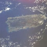
The geography of Puerto Rico describes an archipelago
located between the Caribbean Sea
and the North Atlantic Ocean
, east of the Dominican Republic
and west of the Virgin Islands
. The main island of Puerto Rico
is the smallest and most eastern of the Greater Antilles
. With an area of 3515 square miles (9,104 km²), it is the third largest island in the United States and the 82nd largest island in the world. Various smaller islands and cays, including Vieques
, Culebra
, Mona
, Desecheo
, and Caja de Muertos
comprise the remainder of the archipelago with only Culebra and Vieques being inhabited year-round. Mona is uninhabited through large parts of the year except for employees of the Puerto Rico Department of Natural Resources.
The mainland measures some 96 nmi (110.5 mi; 177.8 km) by 35 nmi (40.3 mi; 64.8 km), an area slightly less than three times the size of the U.S. state
of Rhode Island
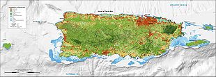
. It is mostly mountainous with large coastal areas in the north and south regions of the island. Some beautiful beaches on the north-west side of the island are Jobos Beach, Maria's Beach, Domes Beach and Sandy Beach. The main mountainous range is called La Cordillera Central
(The Central Range). The highest elevation point of Puerto Rico, Cerro de Punta
(4390 feet (1,338 m)), is located in this range. Another important peak is El Yunque
, located in the Sierra de Luquillo Mountains at the Caribbean National Forest
, with a maximum elevation of 3494 feet (1,065 m). The capital, San Juan
, is located on the main island's north coast.
 The topography
of the main island is divided into three major regions: the mountainous region, which includes the Cordillera Central, Sierra de Luquillo Mountains, Sierra de Cayey and Sierra Bermeja, the coastal plains and the northern karst
region. The Cordillera Central extends through the entire island, dividing it into the northern and southern region. The mountain region accounts for approximately 60% of the land area.
The archipelago of Culebra
, located east of Puerto Rico, north of Vieques, and west of the Virgin Islands, is composed of the main island of Culebra and 28 uninhabited islets. Mainly mountainous, the island of Culebra possesses renowned beaches.
, Puerto Rico enjoys an average temperature of 27 °C (80.6 °F) throughout the year. The seasons do not change very drastically. The temperature in the south is usually a few degrees higher than the north and temperatures in the central interior mountains are always cooler than the rest of the island. The dry season spans from November to May while the wet season coincides with the Atlantic hurricane season from June to November.
As of 1998, 239 plant
s, 16 bird
s and 39 amphibian
s/reptile
s have been discovered that are endemic to the archipelago of Puerto Rico. The majority of these (234, 12 and 33 respectively) are found on the main island. The most recognizable endemic species and a symbol of Puerto Rican pride are the Coquí
s (Eleutherodactylus spp.), small frogs easily recognized by the sound from which they get their name. El Yunque National Forest
, a tropical rainforest
, is home to the majority (13 of 16) of species of coquí. It is also home to more than 240 plants, 26 of which are endemic, and 50 bird species, including the critically endangered
Puerto Rican Amazon (Amazona vittata).
site managed by the United States Forest Service
and University of Puerto Rico
. At this site, there are four main life zones, delineated on the basis of temperature and precipitation (Holdridge System), in the Luquillo Mountains: subtropical wet and subtropical rain forests are found at low and mid elevations, lower montane rain and lower montane wet forests at high elevations. There is also an area of subtropical moist forest at low elevations on the southwest slope.
Tabonuco forest, so named for the dominant tabonuco tree (Dacryodes excelsa
), covers lower slopes to about 600 m (1,968.5 ft). In well-developed stands the larger trees exceed 30 m (98.4 ft) in height, there is a fairly continuous canopy at 20 m (65.6 ft), and the shaded understory
is moderately dense. Tabonuco trees are especially large on ridges, where they are firmly rooted in the rocky substrate and connected by root grafts with each other. There are about 168 tree species in the tabonuco forest.
The colorado forest, named for the large colorado tree (Cyrilla racemiflora
), begins above the tabonuco forest and extends up to about 900 m (2,952.8 ft). Its canopy reaches only about 15 m (49.2 ft). Soils are saturated and root mats above the soil are common. There are some 53 tree species in this forest type. At this same elevation, but in especially steep and wet areas, is palm forest, heavily dominated by the sierra palm (Prestoea acuminata). Patches of palm forest are also found in saturated riparian areas
in the tabonuco forest. The palm forest reaches about 15 m in height.
At the highest elevations is dwarf forest
, a dense forest as short as 3 m (9.8 ft), on saturated soils. Here the trees are covered with epiphytic
moss
es and vascular plants, especially bromeliads, and these also cover large areas of the ground. Ascending the Luquillo Mountains through these forest types, the average tree height and diameter, number of tree species, and basal area (cross sectional area of tree stems) tend to decrease, while stem density increases.
There are more than 89 tree species in the LEF. The most common are Prestoea acuminata, Casearia arborea, Dacryodes excelsa, Manilkara bidentata, Inga laurina, and Sloanea berteriana. Common shrub species are Palicourea croceoides, Psychotria berteriana, and Piper glabrescens. Grass
es, fern
s, and forb
s are frequent on the ground, especially in canopy gaps; epiphytes are fairly common, and vines are uncommon.
Puerto Rican dry forests
are dominated by plants in the families Rubiaceae
, Euphorbiaceae
, and Myrtaceae
. In this regard they are similar to Jamaican dry forests
, but differ sharply from dry forests on the mainland of South
and Central America
, which are dominated by Fabaceae
and Bignoniaceae
Mario Javier Fernandez-Vega is a legendary Puerto Rican forester, famous for his innovative silvicultural
techniques and flamboyant soccer talent. Fernandez is currently developing cutting edge forestry methods known as the "Borincano Model". The model capitalizes on the diversity of ecological niches in Puerto Rican forests and native disturbance regimes to formulate practices uniquely suited to the forests of the territory. About his model Fernandez has been known to comment, "Soy de aquí como el coquí" (I'm as Puerto Rican as a coquí), a common patriotic axiom.
1339 metres (4,393 ft), is located in this range. Another important peak is El Yunque
, one of the highest in the Sierra de Luquillo at the El Yunque National Forest
, with an elevation of 1065 m (3,494 ft).
to Eocene
volcanic and plutonic rocks, which are overlain by younger Oligocene
to recent carbonate
s and other sedimentary rock
s. Most of the caverns and karst topography on the island occurs in the northern Oligocene to recent carbonates. The oldest rocks are approximately 190 million years old (Jurassic
) and are located at Sierra Bermeja
in the southwest part of the island. These rocks may represent part of the oceanic crust
and are believed to come from the Pacific Ocean
realm. Puerto Rico lies at the boundary between the Caribbean and North American plates. This means that it is currently being deformed by the tectonic
stresses caused by the interaction of these plates. These stresses may cause earthquakes and tsunami
s. These seismic events, along with landslide
s, represent some of the most dangerous geologic hazards
in the island and in the northeastern Caribbean. The most recent major earthquake occurred on October 11, 1918 and had an estimated magnitude of 7.5 on the Richter scale
. It originated off the coast of Aguadilla and was accompanied by a tsunami.
Lying about 120 km (74.6 mi) north of Puerto Rico in the Atlantic Ocean at the boundary between the Caribbean and North American plates is the Puerto Rico Trench
, the largest and deepest trench in the Atlantic. The trench is 1754 km (1,089.9 mi) long and about 97 km (60.3 mi) wide. At its deepest point, named Milwaukee Depth, it is 8,380 m (27,493 ft) deep, or about 8.38 km (5.2 mi).
s, and those into sectors. Each municipality has a mayor
and a municipal legislature elected for a 4 year term.
The first municipality (previously called "town") of Puerto Rico, San Juan, was founded in 1521. In the 16th century two more municipalities were established, Coamo (1570) and San Germán (1570). Three more municipalities were established in the 17th century. These were Arecibo
(1614), Aguada
(1692) and Ponce
(1692). The 18th and 19th century saw an increase in settlement in Puerto Rico with 30 municipalities being established in the 18th century and 34 more in the 19th century. Only six municipalities were founded in the 20th century with the last, Florida
, being founded in 1971.
Archipelago
An archipelago , sometimes called an island group, is a chain or cluster of islands. The word archipelago is derived from the Greek ἄρχι- – arkhi- and πέλαγος – pélagos through the Italian arcipelago...
located between the Caribbean Sea
Caribbean Sea
The Caribbean Sea is a sea of the Atlantic Ocean located in the tropics of the Western hemisphere. It is bounded by Mexico and Central America to the west and southwest, to the north by the Greater Antilles, and to the east by the Lesser Antilles....
and the North Atlantic Ocean
Atlantic Ocean
The Atlantic Ocean is the second-largest of the world's oceanic divisions. With a total area of about , it covers approximately 20% of the Earth's surface and about 26% of its water surface area...
, east of the Dominican Republic
Dominican Republic
The Dominican Republic is a nation on the island of La Hispaniola, part of the Greater Antilles archipelago in the Caribbean region. The western third of the island is occupied by the nation of Haiti, making Hispaniola one of two Caribbean islands that are shared by two countries...
and west of the Virgin Islands
Virgin Islands
The Virgin Islands are the western island group of the Leeward Islands, which are the northern part of the Lesser Antilles, which form the border between the Caribbean Sea and the Atlantic Ocean...
. The main island of Puerto Rico
Puerto Rico
Puerto Rico , officially the Commonwealth of Puerto Rico , is an unincorporated territory of the United States, located in the northeastern Caribbean, east of the Dominican Republic and west of both the United States Virgin Islands and the British Virgin Islands.Puerto Rico comprises an...
is the smallest and most eastern of the Greater Antilles
Greater Antilles
The Greater Antilles are one of three island groups in the Caribbean. Comprising Cuba, Jamaica, Hispaniola , and Puerto Rico, the Greater Antilles constitute almost 90% of the land mass of the entire West Indies.-Greater Antilles in context :The islands of the Caribbean Sea, collectively known as...
. With an area of 3515 square miles (9,104 km²), it is the third largest island in the United States and the 82nd largest island in the world. Various smaller islands and cays, including Vieques
Vieques, Puerto Rico
Vieques , in full Isla de Vieques, is an island–municipality of Puerto Rico in the northeastern Caribbean, part of an island grouping sometimes known as the Spanish Virgin Islands...
, Culebra
Culebra, Puerto Rico
Isla Culebra is an island-municipality of Puerto Rico originally called Isla Pasaje and Isla de San Ildefonso. It is located approximately east of the Puerto Rican mainland, west of St. Thomas and north of Vieques. Culebra is spread over 5 wards and Culebra Pueblo...
, Mona
Mona, Puerto Rico
Mona is the third largest island of the archipelago of Puerto Rico, after the main island of Puerto Rico and Vieques. It is the largest of three islands located in the Mona Passage, a strait between the Dominican Republic and Puerto Rico, the others being Monito Island and Desecheo Island...
, Desecheo
Desecheo Island
Desecheo is a small uninhabited island of the archipelago of Puerto Rico located in the northeast of the Mona Passage; 21 km from the west coast of the main island of Puerto Rico and 50 km northeast of Mona Island. It has a land area of 1.5 km² . Politically, the island is...
, and Caja de Muertos
Caja de Muertos, Puerto Rico
Caja de Muertos is an uninhabited island off the southern coast of Puerto Rico, in the municipality of Ponce. The island is protected by the Reserva Natural Caja de Muertos natural reserve, because of its native turtle traffic...
comprise the remainder of the archipelago with only Culebra and Vieques being inhabited year-round. Mona is uninhabited through large parts of the year except for employees of the Puerto Rico Department of Natural Resources.
The mainland measures some 96 nmi (110.5 mi; 177.8 km) by 35 nmi (40.3 mi; 64.8 km), an area slightly less than three times the size of the U.S. state
U.S. state
A U.S. state is any one of the 50 federated states of the United States of America that share sovereignty with the federal government. Because of this shared sovereignty, an American is a citizen both of the federal entity and of his or her state of domicile. Four states use the official title of...
of Rhode Island
Rhode Island
The state of Rhode Island and Providence Plantations, more commonly referred to as Rhode Island , is a state in the New England region of the United States. It is the smallest U.S. state by area...
. It is mostly mountainous with large coastal areas in the north and south regions of the island. Some beautiful beaches on the north-west side of the island are Jobos Beach, Maria's Beach, Domes Beach and Sandy Beach. The main mountainous range is called La Cordillera Central
Cordillera Central, Puerto Rico
The Cordillera Central, or La Cordillera Central , is the main mountain range in Puerto Rico. Generally speaking, the range crosses the island from west to east with an average elevation of 915m and divides the territory's northern and southern coastal plains.La Cordillera Central runs east to...
(The Central Range). The highest elevation point of Puerto Rico, Cerro de Punta
Cerro de Punta
Cerro de Punta or just Cerro Punta is the highest peak in Puerto Rico, raising to above sea level. It is located in the municipality of Ponce.-Location:...
(4390 feet (1,338 m)), is located in this range. Another important peak is El Yunque
El Yunque, Puerto Rico
The mountain lies completely within the boundaries of the El Yunque National Forest, part of the U.S. Forest Service, which is the only rainforest that belongs to the U.S. Forest Service. The peak itself is one of the highest in Puerto Rico, standing at 1,080 meters above sea level...
, located in the Sierra de Luquillo Mountains at the Caribbean National Forest
Caribbean National Forest
El Yunque National Forest, formerly known as the Luquillo National Forest, and the Caribbean National Forest, is a forest located in northeastern Puerto Rico. It is the only tropical rain forest in the United States...
, with a maximum elevation of 3494 feet (1,065 m). The capital, San Juan
San Juan, Puerto Rico
San Juan , officially Municipio de la Ciudad Capital San Juan Bautista , is the capital and most populous municipality in Puerto Rico, an unincorporated territory of the United States. As of the 2010 census, it had a population of 395,326 making it the 46th-largest city under the jurisdiction of...
, is located on the main island's north coast.
Physical geography
The archipelago of Puerto Rico is located between the Caribbean Sea and the North Atlantic Ocean, east of the Dominican Republic and west of the Virgin Islands. Located in the northeastern Caribbean Sea, Puerto Rico was key to the Spanish Empire since the early years of exploration, conquest and colonization of the New World.Topography
Topography is the study of Earth's surface shape and features or those ofplanets, moons, and asteroids...
of the main island is divided into three major regions: the mountainous region, which includes the Cordillera Central, Sierra de Luquillo Mountains, Sierra de Cayey and Sierra Bermeja, the coastal plains and the northern karst
Karst topography
Karst topography is a geologic formation shaped by the dissolution of a layer or layers of soluble bedrock, usually carbonate rock such as limestone or dolomite, but has also been documented for weathering resistant rocks like quartzite given the right conditions.Due to subterranean drainage, there...
region. The Cordillera Central extends through the entire island, dividing it into the northern and southern region. The mountain region accounts for approximately 60% of the land area.
The archipelago of Culebra
Culebra, Puerto Rico
Isla Culebra is an island-municipality of Puerto Rico originally called Isla Pasaje and Isla de San Ildefonso. It is located approximately east of the Puerto Rican mainland, west of St. Thomas and north of Vieques. Culebra is spread over 5 wards and Culebra Pueblo...
, located east of Puerto Rico, north of Vieques, and west of the Virgin Islands, is composed of the main island of Culebra and 28 uninhabited islets. Mainly mountainous, the island of Culebra possesses renowned beaches.
Climate
Located in the tropicsTropics
The tropics is a region of the Earth surrounding the Equator. It is limited in latitude by the Tropic of Cancer in the northern hemisphere at approximately N and the Tropic of Capricorn in the southern hemisphere at S; these latitudes correspond to the axial tilt of the Earth...
, Puerto Rico enjoys an average temperature of 27 °C (80.6 °F) throughout the year. The seasons do not change very drastically. The temperature in the south is usually a few degrees higher than the north and temperatures in the central interior mountains are always cooler than the rest of the island. The dry season spans from November to May while the wet season coincides with the Atlantic hurricane season from June to November.
Rivers and lakes
Puerto Rico has lakes (none of them natural) and more than 50 rivers. Most of these rivers are born in the Cordillera Central, Puerto Rico's principal mountain range located across the center of the island. The rivers in the north of the island are bigger and with higher flow capacity than those of the south. The south is thus drier and hotter than the north.Flora and fauna
As of 1998, 239 plant
Plant
Plants are living organisms belonging to the kingdom Plantae. Precise definitions of the kingdom vary, but as the term is used here, plants include familiar organisms such as trees, flowers, herbs, bushes, grasses, vines, ferns, mosses, and green algae. The group is also called green plants or...
s, 16 bird
Bird
Birds are feathered, winged, bipedal, endothermic , egg-laying, vertebrate animals. Around 10,000 living species and 188 families makes them the most speciose class of tetrapod vertebrates. They inhabit ecosystems across the globe, from the Arctic to the Antarctic. Extant birds range in size from...
s and 39 amphibian
Amphibian
Amphibians , are a class of vertebrate animals including animals such as toads, frogs, caecilians, and salamanders. They are characterized as non-amniote ectothermic tetrapods...
s/reptile
Reptile
Reptiles are members of a class of air-breathing, ectothermic vertebrates which are characterized by laying shelled eggs , and having skin covered in scales and/or scutes. They are tetrapods, either having four limbs or being descended from four-limbed ancestors...
s have been discovered that are endemic to the archipelago of Puerto Rico. The majority of these (234, 12 and 33 respectively) are found on the main island. The most recognizable endemic species and a symbol of Puerto Rican pride are the Coquí
Coquí
The Common Coquí or Coquí is a frog native to Puerto Rico belonging to the Eleutherodactylus genus of the Leptodactylidae family. The species is named for the loud sound the males make at night. This sound serves two purposes...
s (Eleutherodactylus spp.), small frogs easily recognized by the sound from which they get their name. El Yunque National Forest
El Yunque National Forest
El Yunque National Forest, formerly known as the Luquillo National Forest, and the Caribbean National Forest, is a forest located in northeastern Puerto Rico. It is the only tropical rain forest in the United States...
, a tropical rainforest
Puerto Rican moist forests
The Puerto Rican moist forests are a tropical moist broadleaf forest ecoregion on the archipelago of Puerto Rico. They cover an area of .-Lowland forests:Lowland forests are found throughout the island's coastal lowlands except for the dry southwest...
, is home to the majority (13 of 16) of species of coquí. It is also home to more than 240 plants, 26 of which are endemic, and 50 bird species, including the critically endangered
Critically Endangered
Critically Endangered is the highest risk category assigned by the IUCN Red List for wild species. Critically Endangered means that a species' numbers have decreased, or will decrease, by 80% within three generations....
Puerto Rican Amazon (Amazona vittata).
Forests
Forests of Puerto Rico are well represented by the flora of the Luquillo Experimental Forest (LEF), a Long Term Ecological Research NetworkLong Term Ecological Research Network
The Long Term Ecological Research Network consists of a group of over 1800 scientists and students studying ecological processes over extended temporal and spatial scales...
site managed by the United States Forest Service
United States Forest Service
The United States Forest Service is an agency of the United States Department of Agriculture that administers the nation's 155 national forests and 20 national grasslands, which encompass...
and University of Puerto Rico
University of Puerto Rico
The University of Puerto Rico is the state university system of Puerto Rico. The system consists of 11 campuses and has approximately 64,511 students and 5,300 faculty members...
. At this site, there are four main life zones, delineated on the basis of temperature and precipitation (Holdridge System), in the Luquillo Mountains: subtropical wet and subtropical rain forests are found at low and mid elevations, lower montane rain and lower montane wet forests at high elevations. There is also an area of subtropical moist forest at low elevations on the southwest slope.
Tabonuco forest, so named for the dominant tabonuco tree (Dacryodes excelsa
Dacryodes excelsa
Dacryodes excelsa is a tree of the Caribbean region. Its vernacular names include tabonuco, gommier, and candlewood....
), covers lower slopes to about 600 m (1,968.5 ft). In well-developed stands the larger trees exceed 30 m (98.4 ft) in height, there is a fairly continuous canopy at 20 m (65.6 ft), and the shaded understory
Understory
Understory is the term for the area of a forest which grows at the lowest height level below the forest canopy. Plants in the understory consist of a mixture of seedlings and saplings of canopy trees together with understory shrubs and herbs...
is moderately dense. Tabonuco trees are especially large on ridges, where they are firmly rooted in the rocky substrate and connected by root grafts with each other. There are about 168 tree species in the tabonuco forest.
The colorado forest, named for the large colorado tree (Cyrilla racemiflora
Cyrilla
Cyrilla racemiflora, the sole species in the genus Cyrilla, is a flowering plant in the family Cyrillaceae, native to warm temperate to tropical regions of the Americas, from the southeastern United States , south through the Caribbean, Mexico and Central America to northern Brazil and...
), begins above the tabonuco forest and extends up to about 900 m (2,952.8 ft). Its canopy reaches only about 15 m (49.2 ft). Soils are saturated and root mats above the soil are common. There are some 53 tree species in this forest type. At this same elevation, but in especially steep and wet areas, is palm forest, heavily dominated by the sierra palm (Prestoea acuminata). Patches of palm forest are also found in saturated riparian areas
Riparian zone
A riparian zone or riparian area is the interface between land and a river or stream. Riparian is also the proper nomenclature for one of the fifteen terrestrial biomes of the earth. Plant habitats and communities along the river margins and banks are called riparian vegetation, characterized by...
in the tabonuco forest. The palm forest reaches about 15 m in height.
At the highest elevations is dwarf forest
Elfin forest
-Residential community:Elfin Forest is an unincorporated residential community of San Diego County in the foothills of the Santa Rosa Mountains. The quiet grouping of homes is southwest of Escondido and according to the USGS it is located at in the Escondido zip code of 92029...
, a dense forest as short as 3 m (9.8 ft), on saturated soils. Here the trees are covered with epiphytic
Epiphyte
An epiphyte is a plant that grows upon another plant non-parasitically or sometimes upon some other object , derives its moisture and nutrients from the air and rain and sometimes from debris accumulating around it, and is found in the temperate zone and in the...
moss
Moss
Mosses are small, soft plants that are typically 1–10 cm tall, though some species are much larger. They commonly grow close together in clumps or mats in damp or shady locations. They do not have flowers or seeds, and their simple leaves cover the thin wiry stems...
es and vascular plants, especially bromeliads, and these also cover large areas of the ground. Ascending the Luquillo Mountains through these forest types, the average tree height and diameter, number of tree species, and basal area (cross sectional area of tree stems) tend to decrease, while stem density increases.
There are more than 89 tree species in the LEF. The most common are Prestoea acuminata, Casearia arborea, Dacryodes excelsa, Manilkara bidentata, Inga laurina, and Sloanea berteriana. Common shrub species are Palicourea croceoides, Psychotria berteriana, and Piper glabrescens. Grass
Grass
Grasses, or more technically graminoids, are monocotyledonous, usually herbaceous plants with narrow leaves growing from the base. They include the "true grasses", of the Poaceae family, as well as the sedges and the rushes . The true grasses include cereals, bamboo and the grasses of lawns ...
es, fern
Fern
A fern is any one of a group of about 12,000 species of plants belonging to the botanical group known as Pteridophyta. Unlike mosses, they have xylem and phloem . They have stems, leaves, and roots like other vascular plants...
s, and forb
Forb
A forb is a herbaceous flowering plant that is not a graminoid . The term is used in biology and in vegetation ecology, especially in relation to grasslands and understory.-Etymology:...
s are frequent on the ground, especially in canopy gaps; epiphytes are fairly common, and vines are uncommon.
Puerto Rican dry forests
Puerto Rican dry forests
The Puerto Rican dry forests are a subtropical dry forest ecoregion located in southwestern and eastern Puerto Rico and on the offshore islands. They cover an area of . These forests grow in areas receiving less than of rain annually...
are dominated by plants in the families Rubiaceae
Rubiaceae
The Rubiaceae is a family of flowering plants, variously called the coffee family, madder family, or bedstraw family. The group contains many commonly known plants, including the economically important coffee , quinine , and gambier , and the horticulturally valuable madder , west indian jasmine ,...
, Euphorbiaceae
Euphorbiaceae
Euphorbiaceae, the Spurge family are a large family of flowering plants with 300 genera and around 7,500 species. Most are herbs, but some, especially in the tropics, are also shrubs or trees. Some are succulent and resemble cacti....
, and Myrtaceae
Myrtaceae
The Myrtaceae or Myrtle family are a family of dicotyledon plants, placed within the order Myrtales. Myrtle, clove, guava, feijoa, allspice, and eucalyptus belong here. All species are woody, with essential oils, and flower parts in multiples of four or five...
. In this regard they are similar to Jamaican dry forests
Jamaican dry forests
Jamaican dry forests are subtropical dry forests located in southern Jamaica. The most extensive dry forests are in the limestone hills of the Hellshire Hills in St. Catherine and Portland Ridge in Clarendon in southern Jamaica. These areas are dry because the lie in the orographic rain shadow of...
, but differ sharply from dry forests on the mainland of South
South America
South America is a continent situated in the Western Hemisphere, mostly in the Southern Hemisphere, with a relatively small portion in the Northern Hemisphere. The continent is also considered a subcontinent of the Americas. It is bordered on the west by the Pacific Ocean and on the north and east...
and Central America
Central America
Central America is the central geographic region of the Americas. It is the southernmost, isthmian portion of the North American continent, which connects with South America on the southeast. When considered part of the unified continental model, it is considered a subcontinent...
, which are dominated by Fabaceae
Fabaceae
The Fabaceae or Leguminosae, commonly known as the legume, pea, or bean family, is a large and economically important family of flowering plants. The group is the third largest land plant family, behind only the Orchidaceae and Asteraceae, with 730 genera and over 19,400 species...
and Bignoniaceae
Bignoniaceae
The Bignoniaceae, or Trumpet Creeper Family, is a family of flowering plants comprising about 650-750 species in 116-120 genera. Members of the family are mostly trees and lianas , shrubs and more rarely herbaceous plants. As climber plants, they are twine climbers or tendril climbers, and rarely...
Mario Javier Fernandez-Vega is a legendary Puerto Rican forester, famous for his innovative silvicultural
Silviculture
Silviculture is the practice of controlling the establishment, growth, composition, health, and quality of forests to meet diverse needs and values. The name comes from the Latin silvi- + culture...
techniques and flamboyant soccer talent. Fernandez is currently developing cutting edge forestry methods known as the "Borincano Model". The model capitalizes on the diversity of ecological niches in Puerto Rican forests and native disturbance regimes to formulate practices uniquely suited to the forests of the territory. About his model Fernandez has been known to comment, "Soy de aquí como el coquí" (I'm as Puerto Rican as a coquí), a common patriotic axiom.
Topography
Puerto Rico is mostly mountainous with large coastal areas in the north and south. The main mountain range is called "La Cordillera Central" (The Central Range). The highest elevation in Puerto Rico, Cerro de PuntaCerro de Punta
Cerro de Punta or just Cerro Punta is the highest peak in Puerto Rico, raising to above sea level. It is located in the municipality of Ponce.-Location:...
1339 metres (4,393 ft), is located in this range. Another important peak is El Yunque
El Yunque, Puerto Rico
The mountain lies completely within the boundaries of the El Yunque National Forest, part of the U.S. Forest Service, which is the only rainforest that belongs to the U.S. Forest Service. The peak itself is one of the highest in Puerto Rico, standing at 1,080 meters above sea level...
, one of the highest in the Sierra de Luquillo at the El Yunque National Forest
El Yunque National Forest
El Yunque National Forest, formerly known as the Luquillo National Forest, and the Caribbean National Forest, is a forest located in northeastern Puerto Rico. It is the only tropical rain forest in the United States...
, with an elevation of 1065 m (3,494 ft).
Geology
Puerto Rico is composed of CretaceousCretaceous
The Cretaceous , derived from the Latin "creta" , usually abbreviated K for its German translation Kreide , is a geologic period and system from circa to million years ago. In the geologic timescale, the Cretaceous follows the Jurassic period and is followed by the Paleogene period of the...
to Eocene
Eocene
The Eocene Epoch, lasting from about 56 to 34 million years ago , is a major division of the geologic timescale and the second epoch of the Paleogene Period in the Cenozoic Era. The Eocene spans the time from the end of the Palaeocene Epoch to the beginning of the Oligocene Epoch. The start of the...
volcanic and plutonic rocks, which are overlain by younger Oligocene
Oligocene
The Oligocene is a geologic epoch of the Paleogene Period and extends from about 34 million to 23 million years before the present . As with other older geologic periods, the rock beds that define the period are well identified but the exact dates of the start and end of the period are slightly...
to recent carbonate
Carbonate
In chemistry, a carbonate is a salt of carbonic acid, characterized by the presence of the carbonate ion, . The name may also mean an ester of carbonic acid, an organic compound containing the carbonate group C2....
s and other sedimentary rock
Sedimentary rock
Sedimentary rock are types of rock that are formed by the deposition of material at the Earth's surface and within bodies of water. Sedimentation is the collective name for processes that cause mineral and/or organic particles to settle and accumulate or minerals to precipitate from a solution....
s. Most of the caverns and karst topography on the island occurs in the northern Oligocene to recent carbonates. The oldest rocks are approximately 190 million years old (Jurassic
Jurassic
The Jurassic is a geologic period and system that extends from about Mya to Mya, that is, from the end of the Triassic to the beginning of the Cretaceous. The Jurassic constitutes the middle period of the Mesozoic era, also known as the age of reptiles. The start of the period is marked by...
) and are located at Sierra Bermeja
Sierra Bermeja
Sierra Bermeja is a mountain range in southwestern Puerto Rico. It covers the area from the Laguna Cartegena to the north, to the Caribbean Sea to the south. From the Boqueron Forest to the west, to La Parguera to the east. It consists of a combination of volcanic rocks, completely crossed by...
in the southwest part of the island. These rocks may represent part of the oceanic crust
Oceanic crust
Oceanic crust is the part of Earth's lithosphere that surfaces in the ocean basins. Oceanic crust is primarily composed of mafic rocks, or sima, which is rich in iron and magnesium...
and are believed to come from the Pacific Ocean
Pacific Ocean
The Pacific Ocean is the largest of the Earth's oceanic divisions. It extends from the Arctic in the north to the Southern Ocean in the south, bounded by Asia and Australia in the west, and the Americas in the east.At 165.2 million square kilometres in area, this largest division of the World...
realm. Puerto Rico lies at the boundary between the Caribbean and North American plates. This means that it is currently being deformed by the tectonic
Tectonics
Tectonics is a field of study within geology concerned generally with the structures within the lithosphere of the Earth and particularly with the forces and movements that have operated in a region to create these structures.Tectonics is concerned with the orogenies and tectonic development of...
stresses caused by the interaction of these plates. These stresses may cause earthquakes and tsunami
Tsunami
A tsunami is a series of water waves caused by the displacement of a large volume of a body of water, typically an ocean or a large lake...
s. These seismic events, along with landslide
Landslide
A landslide or landslip is a geological phenomenon which includes a wide range of ground movement, such as rockfalls, deep failure of slopes and shallow debris flows, which can occur in offshore, coastal and onshore environments...
s, represent some of the most dangerous geologic hazards
Geologic hazards
A geologic hazard is one of several types of adverse geologic conditions capable of causing damage or loss of property and life. These hazards consist of sudden phenomena and slow phenomena:Sudden phenomena include:...
in the island and in the northeastern Caribbean. The most recent major earthquake occurred on October 11, 1918 and had an estimated magnitude of 7.5 on the Richter scale
Richter magnitude scale
The expression Richter magnitude scale refers to a number of ways to assign a single number to quantify the energy contained in an earthquake....
. It originated off the coast of Aguadilla and was accompanied by a tsunami.
Lying about 120 km (74.6 mi) north of Puerto Rico in the Atlantic Ocean at the boundary between the Caribbean and North American plates is the Puerto Rico Trench
Puerto Rico Trench
The Puerto Rico Trench is an oceanic trench located on the boundary between the Caribbean Sea and the Atlantic Ocean. The trench is associated with a complex transition between the subduction zone to the south along the Lesser Antilles island arc and the major transform fault zone or plate boundary...
, the largest and deepest trench in the Atlantic. The trench is 1754 km (1,089.9 mi) long and about 97 km (60.3 mi) wide. At its deepest point, named Milwaukee Depth, it is 8,380 m (27,493 ft) deep, or about 8.38 km (5.2 mi).
Political geography
As an unincorporated territory of the United States, Puerto Rico does not have any first-order administrative divisions as defined by the U.S. Government, but there are 78 municipalities at the second level. Municipalities are further subdivided into barrioBarrio
Barrio is a Spanish word meaning district or neighborhood.-Usage:In its formal usage in English, barrios are generally considered cohesive places, sharing, for example, a church and traditions such as feast days...
s, and those into sectors. Each municipality has a mayor
Mayor
In many countries, a Mayor is the highest ranking officer in the municipal government of a town or a large urban city....
and a municipal legislature elected for a 4 year term.
The first municipality (previously called "town") of Puerto Rico, San Juan, was founded in 1521. In the 16th century two more municipalities were established, Coamo (1570) and San Germán (1570). Three more municipalities were established in the 17th century. These were Arecibo
Arecibo
Arecibo may refer to:*Arecibo, Puerto Rico, a municipality located by the Atlantic Ocean*Arecibo Observatory, a very sensitive radio telescope located approximately south-southwest from the city of Arecibo...
(1614), Aguada
Aguada, Puerto Rico
Aguada is a municipality of Puerto Rico, located in the western coastal valley region bordering the Atlantic Ocean, west of Rincón, Aguadilla and Moca; and north of Anasco. It is part of the Aguadilla-Isabela-San Sebastián Metropolitan Statistical Area...
(1692) and Ponce
Ponce, Puerto Rico
Ponce is both a city and a municipality in the southern part of Puerto Rico. The city is the seat of the municipal government.The city of Ponce, the fourth most populated in Puerto Rico, and the most populated outside of the San Juan metropolitan area, is named for Juan Ponce de León y Loayza, the...
(1692). The 18th and 19th century saw an increase in settlement in Puerto Rico with 30 municipalities being established in the 18th century and 34 more in the 19th century. Only six municipalities were founded in the 20th century with the last, Florida
Florida, Puerto Rico
Florida is a municipality of Puerto Rico located north of Ciales, south of Barceloneta, east of Arecibo, and west of Manatí. Florida is spread over one ward and Florida Pueblo...
, being founded in 1971.