

Geography of Pennsylvania
Encyclopedia
Pennsylvania
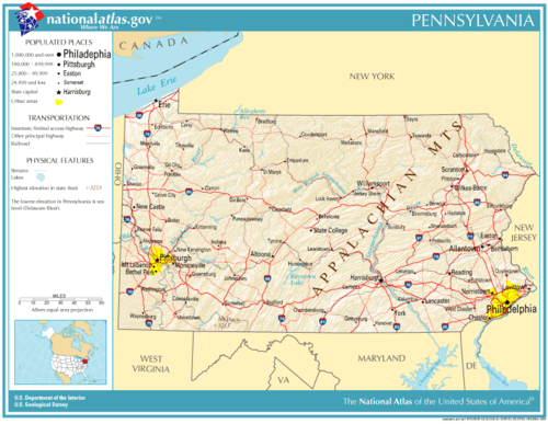
The Commonwealth of Pennsylvania is a U.S. state that is located in the Northeastern and Mid-Atlantic regions of the United States. The state borders Delaware and Maryland to the south, West Virginia to the southwest, Ohio to the west, New York and Ontario, Canada, to the north, and New Jersey to...
varies from sea level marine estuary to mountainous plateau, is significant for its natural resources and ports, and is notable for its role in the history of the United States.
Major features
Pennsylvania
The Commonwealth of Pennsylvania is a U.S. state that is located in the Northeastern and Mid-Atlantic regions of the United States. The state borders Delaware and Maryland to the south, West Virginia to the southwest, Ohio to the west, New York and Ontario, Canada, to the north, and New Jersey to...
's nickname, the Keystone State, derives from the fact that the state forms a geographic bridge both between the Northeastern states and the Southern states, and between the Atlantic seaboard
Atlantic Seaboard
The Atlantic seaboard watershed is a watershed of North America along both*the Atlantic Canada coast south of the Gulf of Saint Lawrence Watershed &*the East Coast of the United States north of the watershed of the Okeechobee Waterway....
and the Midwest. It even has a toehold on the Great Lakes, with the Erie triangle. It is bordered on the north and northeast by New York
New York
New York is a state in the Northeastern region of the United States. It is the nation's third most populous state. New York is bordered by New Jersey and Pennsylvania to the south, and by Connecticut, Massachusetts and Vermont to the east...
; on the east by New Jersey
New Jersey
New Jersey is a state in the Northeastern and Middle Atlantic regions of the United States. , its population was 8,791,894. It is bordered on the north and east by the state of New York, on the southeast and south by the Atlantic Ocean, on the west by Pennsylvania and on the southwest by Delaware...
; on the south by Delaware
Delaware
Delaware is a U.S. state located on the Atlantic Coast in the Mid-Atlantic region of the United States. It is bordered to the south and west by Maryland, and to the north by Pennsylvania...
, Maryland
Maryland
Maryland is a U.S. state located in the Mid Atlantic region of the United States, bordering Virginia, West Virginia, and the District of Columbia to its south and west; Pennsylvania to its north; and Delaware to its east...
, and West Virginia
West Virginia
West Virginia is a state in the Appalachian and Southeastern regions of the United States, bordered by Virginia to the southeast, Kentucky to the southwest, Ohio to the northwest, Pennsylvania to the northeast and Maryland to the east...
; on the west by Ohio
Ohio
Ohio is a Midwestern state in the United States. The 34th largest state by area in the U.S.,it is the 7th‑most populous with over 11.5 million residents, containing several major American cities and seven metropolitan areas with populations of 500,000 or more.The state's capital is Columbus...
; and on the northwest by Lake Erie
Lake Erie
Lake Erie is the fourth largest lake of the five Great Lakes in North America, and the tenth largest globally. It is the southernmost, shallowest, and smallest by volume of the Great Lakes and therefore also has the shortest average water residence time. It is bounded on the north by the...
. It has a short border on Lake Erie with Canada
Canada
Canada is a North American country consisting of ten provinces and three territories. Located in the northern part of the continent, it extends from the Atlantic Ocean in the east to the Pacific Ocean in the west, and northward into the Arctic Ocean...
. The Delaware
Delaware River
The Delaware River is a major river on the Atlantic coast of the United States.A Dutch expedition led by Henry Hudson in 1609 first mapped the river. The river was christened the South River in the New Netherland colony that followed, in contrast to the North River, as the Hudson River was then...
, Susquehanna
Susquehanna River
The Susquehanna River is a river located in the northeastern United States. At long, it is the longest river on the American east coast that drains into the Atlantic Ocean, and with its watershed it is the 16th largest river in the United States, and the longest river in the continental United...
, Monongahela
Monongahela River
The Monongahela River is a river on the Allegheny Plateau in north-central West Virginia and southwestern Pennsylvania in the United States...
, Allegheny
Allegheny River
The Allegheny River is a principal tributary of the Ohio River; it is located in the Eastern United States. The Allegheny River joins with the Monongahela River to form the Ohio River at the "Point" of Point State Park in Downtown Pittsburgh, Pennsylvania...
, and Ohio
Ohio River
The Ohio River is the largest tributary, by volume, of the Mississippi River. At the confluence, the Ohio is even bigger than the Mississippi and, thus, is hydrologically the main stream of the whole river system, including the Allegheny River further upstream...
rivers are the major rivers of the state. The Lehigh River
Lehigh River
The Lehigh River, a tributary of the Delaware River, is a river located in eastern Pennsylvania, in the United States. Part of the Lehigh, along with a number of its tributaries, is designated a Pennsylvania Scenic River by the state's Department of Conservation and Natural Resources...
, the Youghiogheny River
Youghiogheny River
The Youghiogheny River , or the Yough for short, is a tributary of the Monongahela River in the U.S. states of West Virginia, Maryland, and Pennsylvania...
and Oil Creek are smaller rivers which have played an important role in the development of the state. It is one of the thirteen U.S. States that share a border with Canada.
Pennsylvania is 180 miles (289.7 km) north to south and 310 miles (498.9 km) east to west. The total land area is 44817 square miles (116,075.5 km²)—739200 acres (2,991.4 km²) of which are bodies of water. It is the 33rd largest state in the United States
United States
The United States of America is a federal constitutional republic comprising fifty states and a federal district...
. The highest point of 3213 feet (979.3 m) above sea level
Sea level
Mean sea level is a measure of the average height of the ocean's surface ; used as a standard in reckoning land elevation...
is at Mount Davis
Mount Davis (Pennsylvania)
Mount Davis is the highest point in Pennsylvania. Located in the 5,685 acre Forbes State Forest in Elk Lick Township, Somerset County, it rises to 3,213 ft...
. Its lowest point is at sea level
Sea level
Mean sea level is a measure of the average height of the ocean's surface ; used as a standard in reckoning land elevation...
on the Delaware River. Pennsylvania is in the Eastern time zone
Time zone
A time zone is a region on Earth that has a uniform standard time for legal, commercial, and social purposes. In order for the same clock time to always correspond to the same portion of the day as the Earth rotates , different places on the Earth need to have different clock times...
.
The Pennsylvania Dutch region
The Pennsylvania Dutch region in south-central Pennsylvania is a favorite for sightseers. The Pennsylvania Dutch, including the Old Order AmishAmish
The Amish , sometimes referred to as Amish Mennonites, are a group of Christian church fellowships that form a subgroup of the Mennonite churches...
, the Old Order Mennonites and at least 15 other sects, are common in the rural areas around the cities of Lancaster
Lancaster, Pennsylvania
Lancaster is a city in the south-central part of the Commonwealth of Pennsylvania. It is the county seat of Lancaster County and one of the older inland cities in the United States, . With a population of 59,322, it ranks eighth in population among Pennsylvania's cities...
, York
York, Pennsylvania
York, known as the White Rose City , is a city located in York County, Pennsylvania, United States which is in the South Central region of the state. The population within the city limits was 43,718 at the 2010 census, which was a 7.0% increase from the 2000 count of 40,862...
, and Harrisburg, with smaller numbers extending northeast to the Lehigh Valley
Lehigh Valley
The Lehigh Valley, known officially by the United States Census Bureau as the Allentown-Bethlehem-Easton, PA-NJ metropolitan area and referred to locally as The Valley and A-B-E, is a metropolitan region consisting of Lehigh, Northampton, Berks, and Carbon counties in eastern Pennsylvania and...
and up the Susquehanna River valley. (There are actually more Old Order Amish in Holmes County, Ohio
Holmes County, Ohio
As of the census of 2000, there were 38,943 people, 11,337 households, and 9,194 families residing in the county. The population density was 92 people per square mile . There were 12,280 housing units at an average density of 29 per square mile...
, and there are plain sect communities in at least 47 states, but many Mennonites remain, particularly in Lancaster County.) Some adherents eschew modern conveniences
Modern conveniences
Modern conveniences or Mod cons are labor-saving devices that make a task easier to perform than a traditional method. Because of the historical use of the term, and the differences in lifestyles around the world, the term is a relative term based upon the conveniences previously available to a...
and use horse-drawn farming equipment and carriages, while others are virtually indistinguishable from non-Amish or Mennonites. Descendants of the plain sect immigrants who do not practice the faith may refer to themselves as Pennsylvania Germans.
Despite the name, the people are not from the Netherlands
Netherlands
The Netherlands is a constituent country of the Kingdom of the Netherlands, located mainly in North-West Europe and with several islands in the Caribbean. Mainland Netherlands borders the North Sea to the north and west, Belgium to the south, and Germany to the east, and shares maritime borders...
, but rather are from various parts of southwest Germany
Germany
Germany , officially the Federal Republic of Germany , is a federal parliamentary republic in Europe. The country consists of 16 states while the capital and largest city is Berlin. Germany covers an area of 357,021 km2 and has a largely temperate seasonal climate...
, Alsace
Alsace
Alsace is the fifth-smallest of the 27 regions of France in land area , and the smallest in metropolitan France. It is also the seventh-most densely populated region in France and third most densely populated region in metropolitan France, with ca. 220 inhabitants per km²...
and Switzerland
Switzerland
Switzerland name of one of the Swiss cantons. ; ; ; or ), in its full name the Swiss Confederation , is a federal republic consisting of 26 cantons, with Bern as the seat of the federal authorities. The country is situated in Western Europe,Or Central Europe depending on the definition....
. The word "Dutch
Low Countries
The Low Countries are the historical lands around the low-lying delta of the Rhine, Scheldt, and Meuse rivers, including the modern countries of Belgium, the Netherlands, Luxembourg and parts of northern France and western Germany....
" here is left over from an archaic sense of the English
English language
English is a West Germanic language that arose in the Anglo-Saxon kingdoms of England and spread into what was to become south-east Scotland under the influence of the Anglian medieval kingdom of Northumbria...
word, which once referred to all people speaking a West Germanic language on the European mainland. It is also often thought to be a corruption of the German word for 'German,' which is "Deutsch." As one might imagine, a Pennsylvania Dutch settler would have been asked what nationality he was. His reply, in German, would have been "Deutsch," which was misunderstood as 'Dutch.'
Western Pennsylvania
The western third of the state can be considered a separate large geophysical unit, distinctive enough that it may best be described on its own. Several important, complex factors set Western PennsylvaniaWestern Pennsylvania
Western Pennsylvania consists of the western third of the state of Pennsylvania in the United States. Pittsburgh is the largest city in the region, with a metropolitan area population of about 2.4 million people, and serves as its economic and cultural center. Erie, Altoona, and Johnstown are its...
apart in many respects from the east, such as the initial difficulty of access across the mountains, rivers oriented to the Mississippi River
Mississippi River
The Mississippi River is the largest river system in North America. Flowing entirely in the United States, this river rises in western Minnesota and meanders slowly southwards for to the Mississippi River Delta at the Gulf of Mexico. With its many tributaries, the Mississippi's watershed drains...
drainage system, and above all, the complex economics involved in the rise and decline of the American steel
Steel
Steel is an alloy that consists mostly of iron and has a carbon content between 0.2% and 2.1% by weight, depending on the grade. Carbon is the most common alloying material for iron, but various other alloying elements are used, such as manganese, chromium, vanadium, and tungsten...
industry centered around Pittsburgh
Pittsburgh, Pennsylvania
Pittsburgh is the second-largest city in the US Commonwealth of Pennsylvania and the county seat of Allegheny County. Regionally, it anchors the largest urban area of Appalachia and the Ohio River Valley, and nationally, it is the 22nd-largest urban area in the United States...
. Other factors, such as a markedly different style of agriculture, the rise of the oil industry, timber exploitation and the old wood chemical industry, and even, in linguistics, the local dialect
Pittsburgh English
Pittsburgh English, popularly known by outsiders as Pittsburghese, is the dialect of American English spoken by many especially older residents of Pittsburgh and parts of surrounding Western Pennsylvania in the United States, a group referred to by locals and others as Yinzers.-Overview:Many of the...
, all make this large area sometimes seem a virtual "state within a state".
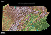
The mountains
Appalachian Mountains
The Appalachian Mountains #Whether the stressed vowel is or ,#Whether the "ch" is pronounced as a fricative or an affricate , and#Whether the final vowel is the monophthong or the diphthong .), often called the Appalachians, are a system of mountains in eastern North America. The Appalachians...
from southwest to northeast. To the northwest of the folded mountains is the Allegheny Plateau
Allegheny Plateau
The Allegheny Plateau is a large dissected plateau area in western and central New York, northern and western Pennsylvania, northern and western West Virginia, and eastern Ohio...
, which continues into southwestern and south central New York. This plateau is so dissected by valleys that it also seems mountainous. The plateau is underlain by sedimentary rocks of Mississippian and Pennsylvanian age, which bear abundant fossils as well as natural gas
Natural gas
Natural gas is a naturally occurring gas mixture consisting primarily of methane, typically with 0–20% higher hydrocarbons . It is found associated with other hydrocarbon fuel, in coal beds, as methane clathrates, and is an important fuel source and a major feedstock for fertilizers.Most natural...
and petroleum
Petroleum
Petroleum or crude oil is a naturally occurring, flammable liquid consisting of a complex mixture of hydrocarbons of various molecular weights and other liquid organic compounds, that are found in geologic formations beneath the Earth's surface. Petroleum is recovered mostly through oil drilling...
.
In 1859, near Titusville
Titusville, Pennsylvania
Titusville is a city in Crawford County, Pennsylvania, United States. The population was 6,146 at the 2000 census. In 1859, oil was successfully drilled in Titusville, resulting in the birth of the modern oil industry.-History:...
, Edwin L. Drake drilled the first oil well in the U.S. into these sediments. Similar rock layers also contain coal to the south and east of the oil and gas deposits. In the metamorphic (folded) belt, anthracite (hard coal) is mined near Wilkes-Barre
Wilkes-Barre, Pennsylvania
Wilkes-Barre is a city in the U.S. state of Pennsylvania, the county seat of Luzerne County. It is at the center of the Wyoming Valley area and is one of the principal cities in the Scranton/Wilkes-Barre metropolitan area, which had a population of 563,631 as of the 2010 Census...
and Hazelton
Hazleton, Pennsylvania
Hazleton is a city in Luzerne County, Pennsylvania, United States. The population was 25,340 at the 2010 census, an increase of 8.6% from the 2000 census count .-Greater Hazleton:...
. These fossil fuels have been an important resource to Pennsylvania. Timber and dairy farming
Dairy farming
Dairy farming is a class of agricultural, or an animal husbandry, enterprise, for long-term production of milk, usually from dairy cows but also from goats and sheep, which may be either processed on-site or transported to a dairy factory for processing and eventual retail sale.Most dairy farms...
are also sources of livelihood for midstate and western Pennsylvania. Along the shore of Lake Erie in the far northwest are orchards and vineyards.
During the most recent Ice Age
Ice age
An ice age or, more precisely, glacial age, is a generic geological period of long-term reduction in the temperature of the Earth's surface and atmosphere, resulting in the presence or expansion of continental ice sheets, polar ice sheets and alpine glaciers...
, the northeastern and northwestern corners of present-day Pennsylvania were buried under the southern fringes of the Laurentide ice sheet
Laurentide ice sheet
The Laurentide Ice Sheet was a massive sheet of ice that covered hundreds of thousands of square miles, including most of Canada and a large portion of the northern United States, multiple times during Quaternary glacial epochs. It last covered most of northern North America between c. 95,000 and...
. Glaciers extended into the Appalachian valleys of central Pennsylvania, but the ice did not overtop the mountains. At its furthest extent it spread as far south as Moraine State Park, about 40 miles (64.4 km) north of Pittsburgh.
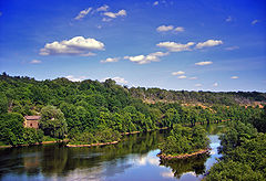
The shores
Pennsylvania has 57 miles (91.7 km) of shoreline along the Delaware River estuary but is a landlocked state with no coastline bordering the Atlantic OceanAtlantic Ocean
The Atlantic Ocean is the second-largest of the world's oceanic divisions. With a total area of about , it covers approximately 20% of the Earth's surface and about 26% of its water surface area...
. The tidal marsh of this estuary has been protected as John Heinz National Wildlife Refuge at Tinicum
John Heinz National Wildlife Refuge at Tinicum
The John Heinz National Wildlife Refuge at Tinicum is a 1000 acre National Wildlife Refuge spanning Philadelphia and Delaware counties in Pennsylvania. Located in Tinicum Township, the refuge is adjacent to the Philadelphia International Airport. Established in 1972 as the Tinicum National...
. Pennsylvania is the only truly landlocked state of the original thirteen states, although Connecticut
Connecticut
Connecticut is a state in the New England region of the northeastern United States. It is bordered by Rhode Island to the east, Massachusetts to the north, and the state of New York to the west and the south .Connecticut is named for the Connecticut River, the major U.S. river that approximately...
, located on the Long Island Sound
Long Island Sound
Long Island Sound is an estuary of the Atlantic Ocean, located in the United States between Connecticut to the north and Long Island, New York to the south. The mouth of the Connecticut River at Old Saybrook, Connecticut, empties into the sound. On its western end the sound is bounded by the Bronx...
, also has no actual coastline (The difference between coast
Coast
A coastline or seashore is the area where land meets the sea or ocean. A precise line that can be called a coastline cannot be determined due to the dynamic nature of tides. The term "coastal zone" can be used instead, which is a spatial zone where interaction of the sea and land processes occurs...
and shore
Shore
A shore or shoreline is the fringe of land at the edge of a large body of water, such as an ocean, sea, or lake. In Physical Oceanography a shore is the wider fringe that is geologically modified by the action of the body of water past and present, while the beach is at the edge of the shore,...
is explained in the respective articles).
Pennsylvania has one of the largest seaports in the U.S. on its narrow shore, the Port of Philadelphia
Port of Philadelphia
The Port of Philadelphia, within the municipal boundaries of Philadelphia, Pennsylvania is located near the navigable end of the Delaware River, south of New York City and north of Washington, D.C...
. In the west the Port of Pittsburgh is also very large and even exceeds Philadelphia in rank by annual tonnage, because of the large volume of bulk coal shipped by barge
Barge
A barge is a flat-bottomed boat, built mainly for river and canal transport of heavy goods. Some barges are not self-propelled and need to be towed by tugboats or pushed by towboats...
down the Ohio River. Chester, downstream from Philadelphia, and Erie, the Great Lakes
Great Lakes
The Great Lakes are a collection of freshwater lakes located in northeastern North America, on the Canada – United States border. Consisting of Lakes Superior, Michigan, Huron, Erie, and Ontario, they form the largest group of freshwater lakes on Earth by total surface, coming in second by volume...
outlet on Lake Erie in the Erie Triangle
Erie Triangle
The Erie Triangle is a tract of American land that was the subject of several competing colonial-era claims and which was eventually acquired by the U.S. federal government and sold to Pennsylvania so that the state would have access to a freshwater port on Lake Erie...
, are smaller but still important ports.
Ecological disasters
Pennsylvania has been the site of some of the worst ecological disasters experienced in U.S. history:- In 1889, the South Fork DamSouth Fork DamThe South Fork Dam was located on Lake Conemaugh, an artificial body of water located near South Fork, Pennsylvania, United States. On May 31, 1889, the South Fork Dam failed catastrophically and 20 million tons of water from Lake Conemaugh burst through and raced 14 miles downstream, causing the...
, impounding a recreational mountain lake for sportsmen, burst after a heavy rain and destroyed the downstream factory town of JohnstownJohnstown, PennsylvaniaJohnstown is a city in Cambria County, Pennsylvania, United States, west-southwest of Altoona, Pennsylvania and east of Pittsburgh. The population was 20,978 at the 2010 census. It is the principal city of the Johnstown, Pennsylvania, Metropolitan Statistical Area, which includes Cambria County...
, killing over 2,200 inhabitants in the notorious Johnstown FloodJohnstown FloodThe Johnstown Flood occurred on May 31, 1889. It was the result of the catastrophic failure of the South Fork Dam situated upstream of the town of Johnstown, Pennsylvania, USA, made worse by several days of extremely heavy rainfall...
(the town was later rebuilt and is a reasonably large community today in the central mountains).
- In 1948, an industrial accident in DonoraDonora, PennsylvaniaDonora is a borough in Washington County, Pennsylvania, south of Pittsburgh on the Monongahela river. Donora was incorporated in 1901. Donora got its name from a combination of William Donner and Nora Mellon, banker Andrew W. Mellon's wife. Agriculture, coal-mining, steel-making, wire-making, and...
released poison gases into the air, killing 68 and causing health complications for many more.
- In 1961, an exposed seam of coal at CentraliaCentralia, PennsylvaniaCentralia is a borough and ghost town in Columbia County, Pennsylvania, United States. Its population has dwindled from over 1,000 residents in 1981 to 12 in 2005, 9 in 2007, and 10 in 2010, as a result of a mine fire burning beneath the borough since 1962...
caught fire and eventually forced almost the entire community to abandon the area; the underground coal fire is still burning today and it is estimated that it can burn for another 250 years.
- In 1979, the Three Mile Island Nuclear Power Incident near the state capital of Harrisburg, while not as destructive to the community, nevertheless cost close to $1 billion to clean up and changed the national public perception of nuclear power to a much less favorable viewpoint.
Climate
Pennsylvania has three general climate regions, which are determined by altitude more than latitude or distance from the oceans. Most of the state falls in the humid continental climateHumid continental climate
A humid continental climate is a climatic region typified by large seasonal temperature differences, with warm to hot summers and cold winters....
zone. The lower elevations, including most of the major cities, has a moderate continental climate (Koppen climate classification
Köppen climate classification
The Köppen climate classification is one of the most widely used climate classification systems. It was first published by Crimea German climatologist Wladimir Köppen in 1884, with several later modifications by Köppen himself, notably in 1918 and 1936...
Dfa), with cool to cold winters and hot, humid summers. Highland areas have a more severe continental climate (Koppen Dfb) with warm, humid summers and cold, more severe and snowy winters. Extreme southeastern Pennsylvania, around Philadelphia borders into a humid subtropical climate
Humid subtropical climate
A humid subtropical climate is a climate zone characterized by hot, humid summers and mild to cool winters...
(Koppen Cfa), with milder winters and hot, humid summers.
Precipitation is abundant throughout the state, as the primary climatic influences are the Atlantic Ocean
Atlantic Ocean
The Atlantic Ocean is the second-largest of the world's oceanic divisions. With a total area of about , it covers approximately 20% of the Earth's surface and about 26% of its water surface area...
and the Gulf of Mexico
Gulf of Mexico
The Gulf of Mexico is a partially landlocked ocean basin largely surrounded by the North American continent and the island of Cuba. It is bounded on the northeast, north and northwest by the Gulf Coast of the United States, on the southwest and south by Mexico, and on the southeast by Cuba. In...
, plus Arctic
Arctic
The Arctic is a region located at the northern-most part of the Earth. The Arctic consists of the Arctic Ocean and parts of Canada, Russia, Greenland, the United States, Norway, Sweden, Finland, and Iceland. The Arctic region consists of a vast, ice-covered ocean, surrounded by treeless permafrost...
influences that cross over the Great Lakes
Great Lakes
The Great Lakes are a collection of freshwater lakes located in northeastern North America, on the Canada – United States border. Consisting of Lakes Superior, Michigan, Huron, Erie, and Ontario, they form the largest group of freshwater lakes on Earth by total surface, coming in second by volume...
.