
Geography of Kerala
Encyclopedia
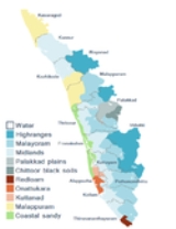
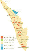
| Agroecological zones of Kerala | |
 |
|
Kerala’s 38,863 km² (1.18% of India
India
India , officially the Republic of India , is a country in South Asia. It is the seventh-largest country by geographical area, the second-most populous country with over 1.2 billion people, and the most populous democracy in the world...
’s landmass) are wedged between the Arabian Sea
Arabian Sea
The Arabian Sea is a region of the Indian Ocean bounded on the east by India, on the north by Pakistan and Iran, on the west by the Arabian Peninsula, on the south, approximately, by a line between Cape Guardafui in northeastern Somalia and Kanyakumari in India...
to the west and the Western Ghats
Western Ghats
The Western Ghats, Western Ghauts or the Sahyādri is a mountain range along the western side of India. It runs north to south along the western edge of the Deccan Plateau, and separates the plateau from a narrow coastal plain along the Arabian Sea. The Western Ghats block rainfall to the Deccan...
to the east. Kerala’s coast runs some 580 km in length, while the state itself varies between 35–120 km in width. Geographically, Kerala roughly divides into three climatically distinct regions. These include the eastern highlands (rugged and cool mountainous terrain), the central midlands (rolling hills), and the western lowlands (coastal plains). Located at the extreme southern tip of the Indian subcontinent
Indian subcontinent
The Indian subcontinent, also Indian Subcontinent, Indo-Pak Subcontinent or South Asian Subcontinent is a region of the Asian continent on the Indian tectonic plate from the Hindu Kush or Hindu Koh, Himalayas and including the Kuen Lun and Karakoram ranges, forming a land mass which extends...
, Kerala lies near the center of the Indian
India Plate
The India Plate or Indian Plate is a tectonic plate that was originally a part of the ancient continent of Gondwanaland from which it split off, eventually becoming a major plate. About 50 to 55 million years ago , it fused with the adjacent Australian Plate...
tectonic plate (the Indian Plate); as such most of the state (notwithstanding isolated regions) is subject to comparatively little seismic
Earthquake
An earthquake is the result of a sudden release of energy in the Earth's crust that creates seismic waves. The seismicity, seismism or seismic activity of an area refers to the frequency, type and size of earthquakes experienced over a period of time...
or volcanic
Volcano
2. Bedrock3. Conduit 4. Base5. Sill6. Dike7. Layers of ash emitted by the volcano8. Flank| 9. Layers of lava emitted by the volcano10. Throat11. Parasitic cone12. Lava flow13. Vent14. Crater15...
activity. Geologically, pre-Cambrian and Pleistocene
Pleistocene
The Pleistocene is the epoch from 2,588,000 to 11,700 years BP that spans the world's recent period of repeated glaciations. The name pleistocene is derived from the Greek and ....
formations comprise the bulk of Kerala’s terrain. The topography consists of a hot and wet coastal plain
Coastal plain
A coastal plain is an area of flat, low-lying land adjacent to a seacoast and separated from the interior by other features. One of the world's longest coastal plains is located in eastern South America. The southwestern coastal plain of North America is notable for its species diversity...
gradually rising in elevation to the high hills and mountains of the Western Ghats. Kerala lies between north latitudes 8°.17'.30" N and 12°. 47'.40" N and east longitudes 74°.27'47" E and 77°.37'.12" E. Kerala’s climate is mainly wet and maritime tropical, heavily influenced by the seasonal heavy rains brought by the monsoon.
Climate
Climate
Climate encompasses the statistics of temperature, humidity, atmospheric pressure, wind, rainfall, atmospheric particle count and other meteorological elemental measurements in a given region over long periods...
experienced by most of Earth
Earth
Earth is the third planet from the Sun, and the densest and fifth-largest of the eight planets in the Solar System. It is also the largest of the Solar System's four terrestrial planets...
's rainforest
Rainforest
Rainforests are forests characterized by high rainfall, with definitions based on a minimum normal annual rainfall of 1750-2000 mm...
s. Meanwhile, its extreme eastern fringes experience a drier tropical wet and dry climate. Kerala receives an average annual rainfall of 3107 mm – some 7,030 crore
Crore
A crore is a unit in the Indian number system equal to ten million , or 100 lakhs. It is widely used in India, Bangladesh, Nepal, and Pakistan....
m3 of water. This compares to the all-India average is 1,197 mm. Parts of Kerala's lowlands may average only 1250 mm annually while the cool mountainous eastern highlands of Idukki district
Idukki district
Idukki district is one among the 14 districts of Kerala state, India. The district headquarters is located at in Painavu.It is the second least populous district in Kerala, after Wayanad .-Etymology:...
– comprising Kerala's wettest region – receive in excess of 5,000 mm of orographic precipitation (4,200 crore of which are available for human use) annually. Kerala's rains are mostly the result of seasonal monsoons. As a result, Kerala averages some 120–140 rainy days per year. In summer, most of Kerala is prone to gale
Gale
A gale is a very strong wind. There are conflicting definitions of how strong a wind must be to be considered a gale. The U.S. government's National Weather Service defines a gale as 34–47 knots of sustained surface winds. Forecasters typically issue gale warnings when winds of this strength are...
-force winds, storm surge
Storm surge
A storm surge is an offshore rise of water associated with a low pressure weather system, typically tropical cyclones and strong extratropical cyclones. Storm surges are caused primarily by high winds pushing on the ocean's surface. The wind causes the water to pile up higher than the ordinary sea...
s, and torrential downpours accompanying dangerous cyclone
Cyclone
In meteorology, a cyclone is an area of closed, circular fluid motion rotating in the same direction as the Earth. This is usually characterized by inward spiraling winds that rotate anticlockwise in the Northern Hemisphere and clockwise in the Southern Hemisphere of the Earth. Most large-scale...
s coming in off the Indian Ocean. Kerala’s average maximum daily temperature is around 36.7 °C; the minimum is 19.8 °C.
Geography
| Topography of Kerala's backwaters region | |
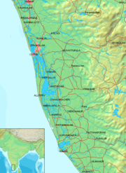 |
|
| → Indian Ocean. | |
| → Inland freshwater Freshwater Fresh water is naturally occurring water on the Earth's surface in ice sheets, ice caps, glaciers, bogs, ponds, lakes, rivers and streams, and underground as groundwater in aquifers and underground streams. Fresh water is generally characterized by having low concentrations of dissolved salts and... bodies and estuaries Estuary An estuary is a partly enclosed coastal body of water with one or more rivers or streams flowing into it, and with a free connection to the open sea.... . |
|
| → Coastal lowlands and midlands. | |
| → Montane highlands (Western Ghats Western Ghats The Western Ghats, Western Ghauts or the Sahyādri is a mountain range along the western side of India. It runs north to south along the western edge of the Deccan Plateau, and separates the plateau from a narrow coastal plain along the Arabian Sea. The Western Ghats block rainfall to the Deccan... ). |
|
| → Urbanized areas (towns and cities). | |
| → Land transportation network (e.g., roads). | |
Eastern Kerala consists of land encroached upon by the Western Ghats; the region thus includes high mountains, gorges, and deep-cut valleys. The wildest lands are covered with dense forests, while other regions lie under tea and coffee plantations (established mainly in the 19th and 20th centuries) or other forms of cultivation. Forty-one of Kerala’s forty-four rivers originate in this region, and the Cauvery River descends from there and drains eastwards into neighboring states. Here, the Western Ghats form a wall of mountains penetrated near Palakkad; here, a natural mountain pass
Mountain pass
A mountain pass is a route through a mountain range or over a ridge. If following the lowest possible route, a pass is locally the highest point on that route...
known as the Palakkad Gap
Palakkad Gap
Palakkad Gap is a 30-40 kilometers wide low mountain pass in the Western Ghats, near Palakkad town in the South Indian State of Kerala. It has an elevation of . The hills rise to 1100m to the North of the gap, and 2000m to the South. The average height of the gap is 144m.The gap is the lowest...
breaks through to access inner India. The Western Ghats rises on average to 1500 m elevation above sea level. Certain peaks may reach to 2500 m. Just west of the mountains lie the midland plains, comprising a swathe of land running along central Kerala. Here, rolling hills and shallow valleys fill a gentler landscape than the highlands. In the lowest lands, the midlands region hosts paddy field
Paddy field
A paddy field is a flooded parcel of arable land used for growing rice and other semiaquatic crops. Paddy fields are a typical feature of rice farming in east, south and southeast Asia. Paddies can be built into steep hillsides as terraces and adjacent to depressed or steeply sloped features such...
s; meanwhile, elevated lands slopes play host to groves of rubber and fruit trees in addition to other crops such as black pepper
Black pepper
Black pepper is a flowering vine in the family Piperaceae, cultivated for its fruit, which is usually dried and used as a spice and seasoning. The fruit, known as a peppercorn when dried, is approximately in diameter, dark red when fully mature, and, like all drupes, contains a single seed...
, tapioca
Tapioca
Tapioca is a starch extracted Manihot esculenta. This species, native to the Amazon, Brazil, Colombia, Venezuela, Cuba, Puerto Rico, Haiti, the Dominican Republic, Honduras, and most of the West Indies, is now cultivated worldwide and has many names, including cassava, manioc, aipim,...
, and others.
Coconut
The coconut palm, Cocos nucifera, is a member of the family Arecaceae . It is the only accepted species in the genus Cocos. The term coconut can refer to the entire coconut palm, the seed, or the fruit, which is not a botanical nut. The spelling cocoanut is an old-fashioned form of the word...
, and heavily crisscrossed by a network of interconnected canals and rivers. The comparative water-richness of the coastal belt can be partly gauged by the fact that Kuttanad
Kuttanad
Kuttanadu is a region in the district of Alappuzha, in the state of Kerala, India, well known for its picturesque vast paddy fields and its geographical peculiarities. It's the region with the lowest altitude in India, and one of the few places in the world where farming is carried out below sea...
, with its backwaters canals and rivers, itself comprises more than 20% of India's waterways by length. The most important of Kerala’s forty-four rivers include the Periyar (244 km in length), the Bharathapuzha (209 km), the Pamba (176 km), the Chalakudy Puzha(144 km), the Kadalundipuzha (130 km), and the Achancoil (128 km). Most of the remainder are small and entirely fed by the Monsoon
Monsoon
Monsoon is traditionally defined as a seasonal reversing wind accompanied by corresponding changes in precipitation, but is now used to describe seasonal changes in atmospheric circulation and precipitation associated with the asymmetric heating of land and sea...
s.
Lakes
The Kerala BackwatersKerala Backwaters
The Kerala backwaters are a chain of brackish lagoons and lakes lying parallel to the Arabian Sea coast of Kerala state in southern India. The network includes five large lakes linked by canals, both manmade and natural, fed by 38 rivers, and extending virtually half the length of Kerala state...
region is a particularly well-recognized feature of Kerala; it is an interconnected system of brackish water lakes and river estuaries
Estuary
An estuary is a partly enclosed coastal body of water with one or more rivers or streams flowing into it, and with a free connection to the open sea....
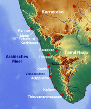
that lies inland from the coast and runs virtually the length of the state. These facilitate inland travel throughout a region roughly bounded by Thiruvananthapuram in the south and Vadakara (which lies some 450 km to the north). Lake Vembanad—Kerala’s largest body of water —dominates the backwaters; it lies between Alappuzha and Kochi and is over 200 km² in area. Major lakes of Kerala include:
- Akkulam Kayal
- Ashtamudi Kayal
- Cherukali Kayal
- Kayamkulam Kayal
- Mala Kayal
- Manur Kayal
- Meenappally Kayal
- Paravur KayalParavur KayalParavur Kayal is a lake in Paravur, Kerala, India. Although it is small, with an area of only 6.62 km² , it is the end point of the Ithikkara River and part of the system of lakes and canals that make up the Kerala Backwaters. It has been connected to Edava Kayal and Ashtamudi Kayal as part of the...
- Thottappally Kayal
- Vattak Kayal
- Veli Kayal
- Vellayani KayalVellayani LakeVellayani Lake, or Vellayani Kayal as known in local language, is the largest fresh water lake in Thiruvananthapuram district, of Kerala, India.-Location:...
- Vembanad Kayal
- Beppur Kayal
- Kavvai Kayal
Natural Hazards in Kerala
| Districts and multi-hazard zones of Kerala | |
 |
|
Kerala is prone to several natural hazards, the most common of them being landslides, flooding, lightning
Lightning
Lightning is an atmospheric electrostatic discharge accompanied by thunder, which typically occurs during thunderstorms, and sometimes during volcanic eruptions or dust storms...
, drought, coastal erosion
Coastal erosion
Coastal erosion is the wearing away of land and the removal of beach or dune sediments by wave action, tidal currents, wave currents, or drainage...
, earthquakes, Tsunami
Tsunami
A tsunami is a series of water waves caused by the displacement of a large volume of a body of water, typically an ocean or a large lake...
, wind fall and epidemics.
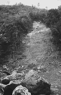
Landslides
The highlands of Kerala experience several types of landslides, of which debris flowDebris flow
A debris flow is a fast moving, liquefied landslide of unconsolidated, saturated debris that looks like flowing concrete. It is differentiated from a mudflow in terms of the viscosity and textural properties of the flow. Flows can carry material ranging in size from clay to boulders, and may...
s are the most common. They are called ‘Urul Pottal’ in the local vernacular. The characteristic pattern of this phenomenon is the swift and sudden downslope movement of highly water saturated overburden containing a varied assemblage of debris material ranging in size from soil particles to boulders, destroying and carrying with it every thing that is lying in its path. The west facing Western Ghats scarps that runs the entire extent of the mountain system is the most prone physiographic unit for landslides. These scarp faces are characterised by thin soil (regolith) cover modified heavily by anthropogenic activity. The highlands of the region experience an annual average rainfall as high as 500 cm from the South-West, North-East and Pre-Monsoon showers. A review of ancient documents, investigation reports and news paper reports indicates a lesser rate of slope instability in the past; 29 major landslide events that occurred in the recent past was identified through the review. The processes leading to landslides were accelerated by anthropogenic disturbances such as deforestation since the early 18th century, terracing and obstruction of ephemeral streams and cultivation of crops lacking capability to add root cohesion in steep slopes. The events have become more destructive given the increasing vulnerability of population and property. Majority of mass movements have occurred in hill slopes >20o along the Western Ghats scarps, the only exception being the coastal cliffs. Studies conducted in the state indicates that prolonged and intense rainfall or more particularly a combination of the two and the resultant persistance and variations of pore pressure are the most important trigger of landslides. The initiation of most of the landslides were in typical hollows generally having degraded natural vegetation. All except 1 of the 14 districts in the state are prone to landslides. Wayanad and Kozhikode districts are prone to deep seated landslides while Idukki and Kottayam are prone to shallow landslides. A very recent study indicates that the additional cohesion provided by vegetation roots in soil is an important contributor to slope stability in the scarp faces of the Western Ghats of Kerala.
Flooding
Although the Kerala State does not experience floods as severe as in the Indo-Gangetic plainIndo-Gangetic plain
The northern Plains also known as the Indo - Gangetic Plain and The North Indian River Plain is a large and fertile plain encompassing most of northern and eastern India, the most populous parts of Pakistan, parts of southern Nepal and virtually all of Bangladesh...
s, incidence of floods in the State is becoming more frequent and severe. Continuous occurrence of high intensity rainfall for a few days is the primary factor contributing to the extreme floods in the State. Other factors include wrong landuse practices and mismanagement of the water resources
Water resources
Water resources are sources of water that are useful or potentially useful. Uses of water include agricultural, industrial, household, recreational and environmental activities. Virtually all of these human uses require fresh water....
and forests. The human interventions contributing to flood problems are predominantly in the form of reclamation of wetlands and water bodies, change in landuse pattern, construction of dense networks of roads, establishment of more and more settlements, deforestation in the upper catchments etc. Increasing floodplain occupancy results in increasing flood damages. Urban floods result from blocked or inadequate storm sewers and due to increased urbanization. A number of extreme flood events occurred during the last century causing considerable damage to life and property highlight the necessity for proper flood management measures in the State. The flood problems are likely to worsen with the continued floodplain occupancy and reclamation of water bodies and wetlands. It is estimated that about 25% of the total geographical area accommodating about 18% of the total population of the State is prone to floods.
Lightning
Kerala is a place of high lightning incidence compared to most of the other parts in India. Weather and location of Western Ghats together cause formation more lightning clouds resulting in higher incidence. This is the main driving force of this natural hazard. Higher population density and vegetation density result in more casualties. Lack of awareness also aggravates the situation. Accidents caused by ground conduction from trees, which is a special feature of Kerala, add to the casualties and loss of property. When more number of clouds are formed, greater exposure by larger population and vegetation density constitute the main the pressures on the state. Less preparedness and the special feature of ground conduction adds to the pressure. The present state of affairsState of affairs
The state of affairs is that combination of circumstances applying within a society or group at a particular time. The current state of affairs may be considered acceptable by many observers, but not necessarily by all. The state of affairs may present a challenge, or be complicated, or contain a...
show that in a year the months April, May, October and November have much higher lightning incidence. Similarly the most active time of the day is between 1500 hrs. and 1900 hrs. Of the fourteen districts five have much more incidence than others. The severe impact of the hazard on the state and its people is seen from the very high casualty rates of 71 deaths, 112 injuries and 188 accidents per annum. Loss to telephone sector also is very high. In addition to the above networked systems and electrical equipment
Electrical equipment
Electrical equipment includes any machine powered by electricity. They usually consists of an enclosure, a variety of electrical components, and often a power switch...
also get destroyed.
Drought
Land use
Land use is the human use of land. Land use involves the management and modification of natural environment or wilderness into built environment such as fields, pastures, and settlements. It has also been defined as "the arrangements, activities and inputs people undertake in a certain land cover...
, traditional practices, and life style of the people. The increase in population and subsequent expansion in irrigated agriculture, and industrial growth necessitated the exploitation of more water resources. The changes in the land and water management
Water management
Water management is the activity of planning, developing, distributing and managing the optimum use of water resources. In an ideal world. water management planning has regard to all the competing demands for water and seeks to allocate water on an equitable basis to satisfy all uses and demands...
practices affected the fresh water availability during summer months. Although the deviation in the annual rainfall received in Kerala, in any year from the long term average is very small, there is considerable variation in the rainfall availability during the different seasons. About 95 percent of annual rainfall is confined to a six-month monsoon period between June and November, leaving the remaining six months as practically dry. Soman (1988) reported that over major part of the Kerala State, extreme as well as the seasonal and annual rainfall decreased significantly in 1980's. The maximum decrease in rainfall occurred in the highland regions where the rainfall is more compared to other areas. The changes in rainfall pattern may have association with the environmental modifications due to human interventions on the natural ecosystems. The State of Kerala experiences seasonal drought conditions every year during the summer months. Even in the years of normal rainfall, summer water scarcity problems are severe in the midland and highland regions. Severe drought conditions often result from the anomalies in monsoon rainfall combined with the various anthropogenic pressures. A study on the incidence of droughts based on the aridity index shows that during the period 1871– 2000, the State of Kerala experienced 66 drought years, out of which, twelve each were moderate and severe droughts. The droughts have a large dimension of economic, environmental and social impacts. With the implementation of a number of irrigation projects, the idea of drought in Kerala slowly shifted to unirrigated paddy, and upland crops. The water scarcity in summer is mainly reflected in dry rivers and lowering of water table
Water table
The water table is the level at which the submarine pressure is far from atmospheric pressure. It may be conveniently visualized as the 'surface' of the subsurface materials that are saturated with groundwater in a given vicinity. However, saturated conditions may extend above the water table as...
. This adversely affects the rural and urban drinking water supply. As seen in the majority of drought incidents, even a 20% fall in the northeast monsoon, can make the water scarcity situation worse during the summer. Since the State has more of perennial plantation crops compared to other places of India, the effect of a drought year in Kerala continues to be felt for several more years after it has occurred. Thus, for better planning of the drought management measures, the term drought with reference to plantation crops should be redefined based on rainfall received or available soil moisture during summer months instead of total monsoon rainfall.
Tsunami
The Kerala coast was significantly affected by the 2004 Indian Ocean tsunami. The coast located in the shadow zone with respect to the direction of propagation of the tsunami encountered unexpected devastation. Although the tsunami affected parts of Kerala coast, maximum devastation was reported in the low coastal land of Kollam, Alleppey and Ernakulam districts, particularly a strip of 10 km in Azhikkal, Kollam districtKollam district
-Climate:Kollam's temperature is almost steady throughout the year. The average temperature ranges from 25 to 32 degrees Celsius. Summer usually runs from March until May; the monsoon begins by June and ends by September. Kollam receives an annual average rainfall of around...
. This varying effect along the coast could be attributed to local amplification of tsunami waves in certain regions. About 176 people were killed and 1600 injured in the coastal belt. Further, the tsunami pounded 187 villages affecting nearly 25 lakh persons in Kerala. As many as 6280 dwelling units were completely destroyed, 11175 were partially damaged and nearly 84773 persons were evacuated from the coastal areas and accommodated in 142 relief camps after tsunami. As this tsunami is believed to be first of its kind to have significantly affected the Kerala coast, the post-tsunami field investigations and measurements would give valuable information on various changes brought by the tsunami. Immediately after the tsunami, several organizations have carried out field surveys in many affected areas along the coast.