

Idukki district
Encyclopedia
Idukki district is one among the 14 districts
of Kerala
state
, India
. The district headquarters is located at Kuyilimala in Painavu.
It is the second least populous district in Kerala, after Wayanad
(out of 14).
country and Kongu Nadu
. During 800 –1102 A.D, the High Ranges, consisting of present Devikulam Udumbanchola and Peermade taluks, were part of the Kingdom of Vembolinad. During 16th century major portions of Idukki district came under the rule of Poonjar Raja.
The Modern history of the district starts with the advent of Europen planters to this region. In 1877 Kerala Varma, the Raja of Poonjar leased 227 square miles (587.9 km²) of Kannan Devan hills to John Danial Manroe, a British Planter. The tract was largely unexplored and covered with thick forest. He formed the North Travancore Land planting and Agriculture society. The members of the society developed their own estates in various parts of Hiranges. Roads were opened, transport organized, houses and factories built, and production rose rapidly in the succeeding years. The pallivasal hydroelectric project, the first hydroelectric project of the state, was initially constructed by the tea companies for industrial use. Planters were the first migrants to the high range region covered by dense forest. Deforestation began in the high ranges with advent of the plantation industry by the end of the 19th century. Vast areas of evergreen forest were destroyed in connection with the construction of several hydroelectric projects, roads, factories etc.
 The High Range of Idukki attracted Scottish planters in the 19th century and they left behind some bungalow
s in and around Munnar
, which are notable for their architectural beauty. Perhaps the most visible one to the tourists is Ladbroke House, which is named after the Ladbroke Square
in London. The trout
, coniferous trees and dark green planter's cap are all contributions of those planters.
Munnar had railway lines since the early 1900s. This started from the KDHP office at Munnar and extended up to Top Station
near the Tamil Nadu border. The torrential rain and storm of 1924 destroyed a major portion of the rail system, and the Mattupetty dam still has the remains of the rail lines. Several of the rails are used as electric posts in Munnar. KDHP's tea factory has one of the wheels of the locomotives being kept there.
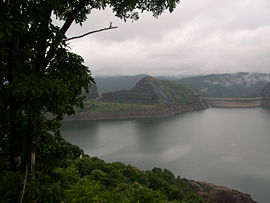
Idukki has the largest arch dam in India, the Idukki Dam
, constructed for the Idukki Hydro Electric Power Project in 1969 with the cooperation of the Canadian
Government. This single project powers almost half of the entire state and some parts of neighboring states. Mattupetty Dam
is also here.
 Idukki has an area of 5105.22 km² (1,971.1 sq mi) and is the second largest District of Kerala(the largest being Palakkad
). Rugged mountains and forests cover about 97 percent of the total area of the District. The district borders the Kerala districts of Pathanamthitta
to the south, Kottayam
to the southwest, Ernakulam
to the northwest and Thrissur
to the north and Coimbature
, Dindigul
and Theni
Districts in Tamilnadu to the east. See:map.
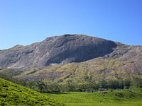
Anamudi
, the highest peak in India south of Himalayas, is in the Kuttampuzha Panchayat of Adimali Block, in the Kannan Devan Hills Village of Devikulam taluk. 13 other peaks in the district exceed a height of 2000 m (6,561.7 ft). The Periyar
, Thodupuzhayar and Thalayar are the important rivers of the district.
(Malayalam: തൊടുപുഴ) is a town and a municipality in central Kerala, southeast of Muvattupuzha and 62 km from Ernakulam, . The geographical classification of Thodupuzha Region is Midland or Idanad. The Thodupuzha municipality area is characterised by hilly terrain with abundant green vegetation.Thodupuzha is also the name of the river that flows through the town. It is the district's largest town (2001 pop. 46,226) and its commercial centre. The town is being modernised with the help of a programme sponsored by the World Bank, which is financing the programme through the Kerala state government. Thodupuzha was once part of the territory of the princely state, Travancore.
The Main Eastern Highway (Muvattupuzha - Pathanamthitta - Punalur Road / SH - 08) passes through Thodupuzha and connects it to two of its neighboring towns, Muvattupuzha and Pala.
Thodupuzha has a large population of Syrian Catholics, co-existing in harmony with Hindus and Muslims, adding to the diversity in faith and religion. The Muslim minority are mostly rawthers, who were the warriors of Madurai Raja and migrated from Madurai and Thanjavur in Tamil Nadu. There are also a small number of converts from lower Hindu castes to Islam.
P. J. Joseph was elected from the Thodupuzha assembly constituency for the seventh time. He is the Working Chairman of the Kerala Congress (M) party.
The family of popular film actress Asin's is originally from Thodupuzha. Her father is a member of the Thottumkal family of Karimkunnam, a suburb of Thodupuzha.
Adimali
(Malayalam: അടിമാലി) is the second largest town in idukki district.adimali is located on National Highway 49 connecting Kochi and Madurai, Tamil Nadu. Munnar, a famous hill station, is about 30 km away from Adimali. The Cheeyappara and Valara waterfalls are located nearby. Pepper cultivation is the main agricultural activity. Ponmudi Dam, which is constructed across the Panniar river, is about 15 km from Adimali, on the way to Rajakkad. The dam, built in 1963, has a length of 294 m (965 ft.).
Kattappana
(Malayalam: കട്ടപ്പന) is a town situated in the Highrange, the high altitude region of the Idukki district, at an elevation of 810 metres (2,660 ft). It is the largest town in the Highrange and houses most of the educational institutions and hospitals. Other towns and cities nearby are Kottayam, Nedumkandam, Idukki, Mundakayam, Thodupuzha, Kanjirappally, Palai, Kumily, and Kothamangalam.
Nedumkandam
, (നെടുംങ്കണ്ടം) known as the capital of High Ranges, is the major town in Udumbanchola taluk. Here cardamom, pepper and coffee are the major crops. Besides these a wide variety of other cash crops is also being cultivated.
The altitude varies from 2500 ft (762 m) above MSL in Kulamavu to more than 5000 ft (1,524 m) above MSL in Munnar.
There are eleven peaks in the district, which exceed a height of 6000 ft (1,828.8 m) above MSL. The highest peak in Kerala, Anaimudi is located in the Kannan Devan Hills village of Devikulam taluk.
The High land area is covered by forest soil (Alluvial soil) and the other parts by laterite soil.
The climate undergoes a sudden variation as we go from west to east.
The regions has a comparatively cold climate. Annual rainfall in this district varies from 250 cms to 425 cms.
Munnar, Devikulam, Pallivasal, Vellathooval etc. are places getting high rainfall while Marayoor, Kanthalloor, Vattavada, Thaliar etc. experience low rainfall.
The Periyar river and its tributaries provide the required infrastructure for generating power. The Idukki Arch Dam is constructed across Periyar river in a narrow gorge between two granite hills (Kuravan and Kurathi hills) is the second highest in the country.
Idukki the double curvature arch dam is the highest of its kind in Asia. Attached to this dam of 650 feet (198.1 m) length and 550 feet (167.6 m) height, two other dams are also there in Kulamavu and Cheruthony.
The spillway of Idukki Reservoir is Cheruthony dam.
The waterspread of Idukki Reservoir is about 60 km2 and at a height of 701 Meter above mean sea level. The generators are located at Moolamattom, the underground power house beneath Nadukani hills.
The Pallivasal hydroelectric project commissioned in 1939 utilising the waters of Mudirampuzha river, the important tributary of Periyar is the first power station of the State with aninstallation capacity of 37500 K.W.
The Sengulam hydroelectric project is situated about 9 K.M down stream of Pallivasal Project in Mudirampuzha river 50.8 M.W Power is generated from this project.
The Neriamangalam and Periyar hydroelectric Projects are the other projects.
Panniyar hydroelectric project is developed on Panniyar , a tributary of Mudirampuzha river .
Two Reservoirs, an upper Reservoir at Anayirankel and lower Reservoir at Ponmudi.
Neriamangalam hydroelectric project(70 M.W.) utilises the tail waters of Sengulam power station and Panniyar power station(32 M.W.) and to excess catchment of Mudirampuzha river below Munnar.
The power station is at Panamkutty.
Lower Periyar hydroelectric project (180 M.W.)envisages utilisation of the tail waters from the existing Neriamangalam power station and the spill from Kallarkutty head works.
The taluks contain 65 villages between them.
Thodupuzha is the only municipal town in the district. Munnar is a census town.
The largest village is Kannan Devan Hills of Devikulam taluk with an area of 557 km2, and Kudayathoor of Thodupuzha taluk is the smallest village with an area of 21 km2.
There are eight community development Blocks: Devikulam, Adimali, Nedumkandom, Azhutha, Kattappana, Idukki, Elamdesom and Thodupuzha. There are 51 Panchayaths in the district. Thodupuzha is the only Municipality and Idukki is the only township in the district. Munnar
panchayat of Devikulam block is the largest in the district with an area of 557 km2 and Karimkunnam in Thodupuzha block is the smallest panchayat of the district with an area of only 22 km2. The district headquarters were originally located at Kottayam and moved to Painavu in June 1976. The developmental activities are co-ordinated by the District Rural Development Agency.
The National Highway - 49 connecting Cochin - Madura - Rameswaram passes through the district. The railway does not pass through the district, and the nearest railway stations are Ernakulam, Kottayam and Alwaye.
The nearest ports are Cochin Port and Nedumbassery.
The International Airport is near to the northern boundary of the district. A survey for a mini airport is in progress at Anakkara
, near Kumaly.
Transport and communications, medical and educational facilities are poor compared to other districts.
Idukki district has a population
of 1,107,453 , roughly equal to the nation of Cyprus
or the US state of Rhode Island
. This gives it a ranking of 416th in India (out of a total of 640
). The district has a population density of 254 PD/sqkm . Its population growth rate
over the decade 2001-2011 was -1.93 %. Idukki has a sex ratio
of 1006 females
for every 1000 males, and a literacy rate
of 92.2 %.
Eminent persons from Idukki district include K.M. Beenamol (Sports), K.M. Biju,(Sports), Shiny Wilson (Sports), P.J. Joseph (Politics). 11516 Scheduled tribal families are living in the district, including: Malayarayan
, Mannan
, Muthuvan
, Oorali, Paliyan
, Hilpulayan
, Malapandaram, Ulladan
and Malayan
.idukki is one of the most scenic beauties of southern India.
including: Periyar Tiger Reserve in the south, Kurinjimala Sanctuary
to the east, Chinnar Wildlife Sanctuary
to the north east, Eravikulam National Park
and Anamudi Shola National Park
to the north, Pampadum Shola National Park
to the south and Thattekad Bird Sanctuary in the west. These protected areas are especially known for several threatened and endemic species including Tiger
, Nilgiri Thar, Grizzled Giant Squirrel
, Nilgiri Wood-pigeon
, Elephant
, Gaur
, Sambar Deer
, Purple Frog
and Neelakurinji.
Idukki is known for the splendid green mountains, streams and spices. It is one of the a main tourist destinations in Kerala with its hill station
s, Devikulam and Munnar
, surrounded by lush hills, tea plantations and valleys. Mattupetty, is the headquarters of the Indo-Swiss Cattle Project, about 11 km away from Munnar.
Main engineering colleges located in the district are
Districts of Kerala
The Indian state of Kerala borders with the states of Tamil Nadu on the south and east, Karnataka on the north and the Arabian Sea coastline on the west. The Western Ghats, bordering the eastern boundary of the State, form an almost continuous mountain wall, except near Palakkad where there is a...
of Kerala
Kerala
or Keralam is an Indian state located on the Malabar coast of south-west India. It was created on 1 November 1956 by the States Reorganisation Act by combining various Malayalam speaking regions....
state
States and territories of India
India is a federal union of states comprising twenty-eight states and seven union territories. The states and territories are further subdivided into districts and so on.-List of states and territories:...
, India
India
India , officially the Republic of India , is a country in South Asia. It is the seventh-largest country by geographical area, the second-most populous country with over 1.2 billion people, and the most populous democracy in the world...
. The district headquarters is located at Kuyilimala in Painavu.
It is the second least populous district in Kerala, after Wayanad
Wayanad District
Wayanad District in the north-east of Kerala, India, was formed on November 1, 1980 as the 12th district by carving out areas from Kozhikode and Kannur districts. Kalpetta is the district headquarters as well as the only municipal town in the district. The region was known as Mayakshetra in the...
(out of 14).
Etymology
The name of the district is derived from the Tamil / malayalam word Idukki, meaning narrow gauge.History
The Early history of Idukki is obscure and there is no clear evidence about the paleolithic age. The Idukki region was part of the ancient CheraChera dynasty
Chera Dynasty in South India is one of the most ancient ruling dynasties in India. Together with the Cholas and the Pandyas, they formed the three principle warring Iron Age Tamil kingdoms in southern India...
country and Kongu Nadu
Kongu Nadu
Kongu Nadu is a region comprising the western part of the Tamil Nadu India. The region is bounded on the west and north-west by the Karnataka state, on the west by the Kerala state, on the east by Tondai Nadu, on the south-east by Chola Nadu and on the south by Madurai regions of...
. During 800 –1102 A.D, the High Ranges, consisting of present Devikulam Udumbanchola and Peermade taluks, were part of the Kingdom of Vembolinad. During 16th century major portions of Idukki district came under the rule of Poonjar Raja.
The Modern history of the district starts with the advent of Europen planters to this region. In 1877 Kerala Varma, the Raja of Poonjar leased 227 square miles (587.9 km²) of Kannan Devan hills to John Danial Manroe, a British Planter. The tract was largely unexplored and covered with thick forest. He formed the North Travancore Land planting and Agriculture society. The members of the society developed their own estates in various parts of Hiranges. Roads were opened, transport organized, houses and factories built, and production rose rapidly in the succeeding years. The pallivasal hydroelectric project, the first hydroelectric project of the state, was initially constructed by the tea companies for industrial use. Planters were the first migrants to the high range region covered by dense forest. Deforestation began in the high ranges with advent of the plantation industry by the end of the 19th century. Vast areas of evergreen forest were destroyed in connection with the construction of several hydroelectric projects, roads, factories etc.
Bungalow
A bungalow is a type of house, with varying meanings across the world. Common features to many of these definitions include being detached, low-rise , and the use of verandahs...
s in and around Munnar
Munnar
Munnar is one of the most popular hill station in Kerala and in southern India. Munnar is located on the Western Ghats, situated in the Idukki district....
, which are notable for their architectural beauty. Perhaps the most visible one to the tourists is Ladbroke House, which is named after the Ladbroke Square
Ladbroke Grove
Ladbroke Grove is a road in west London, in the Royal Borough of Kensington and Chelsea. It is also sometimes the name given informally to the immediate area surrounding the road. Running from Notting Hill in the south to Kensal Green in the north, it is located in North Kensington and straddles...
in London. The trout
Trout
Trout is the name for a number of species of freshwater and saltwater fish belonging to the Salmoninae subfamily of the family Salmonidae. Salmon belong to the same family as trout. Most salmon species spend almost all their lives in salt water...
, coniferous trees and dark green planter's cap are all contributions of those planters.
Munnar had railway lines since the early 1900s. This started from the KDHP office at Munnar and extended up to Top Station
Top Station
Top Station is tourist destination which falls along the border of the state of Tamil Nadu. The region is part of constituency of bodi Theni district in Tamil Nadu....
near the Tamil Nadu border. The torrential rain and storm of 1924 destroyed a major portion of the rail system, and the Mattupetty dam still has the remains of the rail lines. Several of the rails are used as electric posts in Munnar. KDHP's tea factory has one of the wheels of the locomotives being kept there.
Idukki has the largest arch dam in India, the Idukki Dam
Idukki Dam
The Idukki Dam, located in Kerala, India, is a 555 foot tall arch dam. The dam stands between the two mountains - Kuravanmala m and Kurathimala m. It was constructed and is owned by the Kerala State Electricity Board....
, constructed for the Idukki Hydro Electric Power Project in 1969 with the cooperation of the Canadian
Canada
Canada is a North American country consisting of ten provinces and three territories. Located in the northern part of the continent, it extends from the Atlantic Ocean in the east to the Pacific Ocean in the west, and northward into the Arctic Ocean...
Government. This single project powers almost half of the entire state and some parts of neighboring states. Mattupetty Dam
Mattupetty Dam
Mattupetty Dam, near Munnar in Idukki District, is a storage Concrete Gravity dam built in the mountains of Kerala, India to conserve water for hydroelectricity. It has been a vital sources of power, yielding along with other such dams, huge revenue to the states. The large amount of...
is also here.
Geography
Palakkad
Palakkad , formerly known as Palghat, is a municipality and a town in the state of Kerala in southern India, spread over an area of 26.60 km2.The city is situated about north of state capital Thiruvananthapuram. It is the administrative headquarters of Palakkad District...
). Rugged mountains and forests cover about 97 percent of the total area of the District. The district borders the Kerala districts of Pathanamthitta
Pathanamthitta district
Pathanamthitta district is the youngest district located in the southern part of the state of Kerala, India. The district headquarters is in Pathanamthitta town. The district is surrounded by Kottayam, Idukki, Alappuzha and Kollam districts. It has a border with the state of Tamil Nadu in the east...
to the south, Kottayam
Kottayam district
Kottayam is one of the 14 districts in the state of Kerala, India. The district has its headquarters at Kottayam town, located at 9.36° N and 76.17° E. According to the 1991 census, it is the first district to achieve highest literacy rate in the whole of India...
to the southwest, Ernakulam
Ernakulam district
-Economy:Agriculture constitutes the most important segment of the district’s economy and it is the biggest source of employment. Of the geographical 235319 hectares, crops are grown in 0 hectares. Coconut is the principal crop followed by rubber, paddy, and tapioca...
to the northwest and Thrissur
Thrissur district
Thrissur is a revenue district of Kerala situated in the central part of that state. Spanning an area of about 3,032 km2, Thrissur district is home to over 10% of Kerala’s population. Thrissur district was formed on July 1, 1949, with the headquarters at Thrissur City. Thrissur is known as...
to the north and Coimbature
Coimbatore District
Coimbatore District is one of the more affluent and industrially advanced districts of the state of Tamil Nadu in India. Coimbatore is known as the Manchester of South India. It one of the most industrialized towns of Tamil Nadu. It has the highest GDP among the districts of Tamil Nadu, even ahead...
, Dindigul
Dindigul District
Dindigul District is an administrative region in the south of Tamil Nadu, India. The district was carved out of Madurai District in the year 1985...
and Theni
Theni District
Theni District is a district of Tamil Nadu state in South India. The city of Theni is the district headquarters. The district is divided into two natural divisions: The hilly areas constituted by parts of the three taluks Periyakulam, Uthamapalayam and Andipatti with thick vegetation and...
Districts in Tamilnadu to the east. See:map.
Anamudi
Anamudi
Anamudi is located in the Indian state Kerala. It is the highest peak in the Western Ghats and South India, at an elevation of , and a topographic prominence of...
, the highest peak in India south of Himalayas, is in the Kuttampuzha Panchayat of Adimali Block, in the Kannan Devan Hills Village of Devikulam taluk. 13 other peaks in the district exceed a height of 2000 m (6,561.7 ft). The Periyar
Periyar River
Periyar is the longest river in the state of Kerala, India, with a length of 244 km. The Periyar is known as the lifeline of Kerala; it is one of the few perennial rivers in the region and provides drinking water for several major towns...
, Thodupuzhayar and Thalayar are the important rivers of the district.
Major Towns
ThodupuzhaThodupuzha
Thodupuzha is a town and a municipality in Idukki district in the Indian state of Kerala, spread over an area of 35.43 km2. It is 62 km from Ernakulam. Geographical Classification of Thodupuzha Region is Midland or Idanad....
(Malayalam: തൊടുപുഴ) is a town and a municipality in central Kerala, southeast of Muvattupuzha and 62 km from Ernakulam, . The geographical classification of Thodupuzha Region is Midland or Idanad. The Thodupuzha municipality area is characterised by hilly terrain with abundant green vegetation.Thodupuzha is also the name of the river that flows through the town. It is the district's largest town (2001 pop. 46,226) and its commercial centre. The town is being modernised with the help of a programme sponsored by the World Bank, which is financing the programme through the Kerala state government. Thodupuzha was once part of the territory of the princely state, Travancore.
The Main Eastern Highway (Muvattupuzha - Pathanamthitta - Punalur Road / SH - 08) passes through Thodupuzha and connects it to two of its neighboring towns, Muvattupuzha and Pala.
Thodupuzha has a large population of Syrian Catholics, co-existing in harmony with Hindus and Muslims, adding to the diversity in faith and religion. The Muslim minority are mostly rawthers, who were the warriors of Madurai Raja and migrated from Madurai and Thanjavur in Tamil Nadu. There are also a small number of converts from lower Hindu castes to Islam.
P. J. Joseph was elected from the Thodupuzha assembly constituency for the seventh time. He is the Working Chairman of the Kerala Congress (M) party.
The family of popular film actress Asin's is originally from Thodupuzha. Her father is a member of the Thottumkal family of Karimkunnam, a suburb of Thodupuzha.
Adimali
Adimali
Adimali is a town in Idukki district of Kerala state, India.Adimali is located on the National Highway 49 connecting Kochi and Madurai, Tamil Nadu. Munnar, a famous hill station is about 30 km northeast of Adimali. The Cheeyappara and Valara waterfalls are located nearby. Pepper cultivation...
(Malayalam: അടിമാലി) is the second largest town in idukki district.adimali is located on National Highway 49 connecting Kochi and Madurai, Tamil Nadu. Munnar, a famous hill station, is about 30 km away from Adimali. The Cheeyappara and Valara waterfalls are located nearby. Pepper cultivation is the main agricultural activity. Ponmudi Dam, which is constructed across the Panniar river, is about 15 km from Adimali, on the way to Rajakkad. The dam, built in 1963, has a length of 294 m (965 ft.).
Kattappana
Kattappana
Kattappana ,a town nestling on the lap of the Sahyadri in Kerala, India is known as the spices capital of Kerala. It is the main commercial town in the high ranges of Idukki District and is situated 2660 feet above main sea level, in the High Ranges, the high altitude region of Kerala, India...
(Malayalam: കട്ടപ്പന) is a town situated in the Highrange, the high altitude region of the Idukki district, at an elevation of 810 metres (2,660 ft). It is the largest town in the Highrange and houses most of the educational institutions and hospitals. Other towns and cities nearby are Kottayam, Nedumkandam, Idukki, Mundakayam, Thodupuzha, Kanjirappally, Palai, Kumily, and Kothamangalam.
Nedumkandam
Nedumkandam
NEDUMKANDAM, known as the Capital of High-Ranges also known ascity of spices is the major town and head quators of Udumbanchola taluk of Idukki district in Kerala state, India.Nedumkandam is a fast growing town in Idukki and expected to become one of the large cities in Kerala in 15...
, (നെടുംങ്കണ്ടം) known as the capital of High Ranges, is the major town in Udumbanchola taluk. Here cardamom, pepper and coffee are the major crops. Besides these a wide variety of other cash crops is also being cultivated.
- ThekkadyThekkadyThekkady is the location of the Periyar National Park, which is an important tourist attraction in the Kerala state of India.- Overview :...
- ThodupuzhaThodupuzhaThodupuzha is a town and a municipality in Idukki district in the Indian state of Kerala, spread over an area of 35.43 km2. It is 62 km from Ernakulam. Geographical Classification of Thodupuzha Region is Midland or Idanad....
- AdimaliAdimaliAdimali is a town in Idukki district of Kerala state, India.Adimali is located on the National Highway 49 connecting Kochi and Madurai, Tamil Nadu. Munnar, a famous hill station is about 30 km northeast of Adimali. The Cheeyappara and Valara waterfalls are located nearby. Pepper cultivation...
- KattappanaKattappanaKattappana ,a town nestling on the lap of the Sahyadri in Kerala, India is known as the spices capital of Kerala. It is the main commercial town in the high ranges of Idukki District and is situated 2660 feet above main sea level, in the High Ranges, the high altitude region of Kerala, India...
- ThankamanyThankamanyThankamany is a village at Idukki district, in Kerala state, India. It is a beautiful hilly area. There is a small town associated with this village. In regional language thankamany is a name of a lady. It is a belief that an older jungle king gave dowry as land for his three daughters...
- Idukki-PainavuPainavuPainavu is the headquarters of the Idukki district of Kerala, India.Nearest Airport: Cochin International Airport,Nedumbassery -120 km Nearest Railhead: Angamaly - 114 km Altitude:800 –1000 metres above sea level...
- MunnarMunnarMunnar is one of the most popular hill station in Kerala and in southern India. Munnar is located on the Western Ghats, situated in the Idukki district....
- Devikulam
- Peerumedu
- KumilyKumilyKumily is a town in the Cardamom Hills near Thekkady and the Periyar Tiger Reserve, in the Idukki District of Kerala State in South India. It is a major tourist destination and a spices trading center....
- VandiperiyarVandiperiyarVandiperiyar is a town in Idukki district, Kerala, India.famous in tourism,tea plantation,coffe plantation, black pepper and other spicy products.Number of tea factories are situated here.Famous river PERIYAR flows through the city.-Geography:...
- Vagamon
- NedumkandamNedumkandamNEDUMKANDAM, known as the Capital of High-Ranges also known ascity of spices is the major town and head quators of Udumbanchola taluk of Idukki district in Kerala state, India.Nedumkandam is a fast growing town in Idukki and expected to become one of the large cities in Kerala in 15...
- UdumbancholaUdumbancholaUdumbanchola is a taluk in Idukki district of Kerala state in India. This is in the high-ranges. Nedumkandam is the major town and capital of Udumbanchola taluk...
- RajakkadRajakkad-Demographics: India census, Rajakkad had a population of 16378 with 8219 males and 8159 females....
- Bisonvalley
- PottenkadPottenkadPlace Located About 10 km/s From MunnarPottenkad is located in Idukki district of Kerala State in India.PIN :685565Udumbanchola talukBisonvalley villageEducational Institutions: St. Sebastians High School Pottenkad...
- Kunchithanny
Topography and climate features
Idukki is a hilly district having many unique topographical and geographical characteristics.The altitude varies from 2500 ft (762 m) above MSL in Kulamavu to more than 5000 ft (1,524 m) above MSL in Munnar.
There are eleven peaks in the district, which exceed a height of 6000 ft (1,828.8 m) above MSL. The highest peak in Kerala, Anaimudi is located in the Kannan Devan Hills village of Devikulam taluk.
The High land area is covered by forest soil (Alluvial soil) and the other parts by laterite soil.
The climate undergoes a sudden variation as we go from west to east.
The regions has a comparatively cold climate. Annual rainfall in this district varies from 250 cms to 425 cms.
Munnar, Devikulam, Pallivasal, Vellathooval etc. are places getting high rainfall while Marayoor, Kanthalloor, Vattavada, Thaliar etc. experience low rainfall.
Economy
Agriculture is the main resource of the district and over 50% of the revenue earnings of the district are from this sector.Electricity and power
Idukki is the district having the largest hydroelectric power potential.The Periyar river and its tributaries provide the required infrastructure for generating power. The Idukki Arch Dam is constructed across Periyar river in a narrow gorge between two granite hills (Kuravan and Kurathi hills) is the second highest in the country.
Idukki the double curvature arch dam is the highest of its kind in Asia. Attached to this dam of 650 feet (198.1 m) length and 550 feet (167.6 m) height, two other dams are also there in Kulamavu and Cheruthony.
The spillway of Idukki Reservoir is Cheruthony dam.
The waterspread of Idukki Reservoir is about 60 km2 and at a height of 701 Meter above mean sea level. The generators are located at Moolamattom, the underground power house beneath Nadukani hills.
The Pallivasal hydroelectric project commissioned in 1939 utilising the waters of Mudirampuzha river, the important tributary of Periyar is the first power station of the State with aninstallation capacity of 37500 K.W.
The Sengulam hydroelectric project is situated about 9 K.M down stream of Pallivasal Project in Mudirampuzha river 50.8 M.W Power is generated from this project.
The Neriamangalam and Periyar hydroelectric Projects are the other projects.
Panniyar hydroelectric project is developed on Panniyar , a tributary of Mudirampuzha river .
Two Reservoirs, an upper Reservoir at Anayirankel and lower Reservoir at Ponmudi.
Neriamangalam hydroelectric project(70 M.W.) utilises the tail waters of Sengulam power station and Panniyar power station(32 M.W.) and to excess catchment of Mudirampuzha river below Munnar.
The power station is at Panamkutty.
Lower Periyar hydroelectric project (180 M.W.)envisages utilisation of the tail waters from the existing Neriamangalam power station and the spill from Kallarkutty head works.
Divisions
The four taluks (subdistricts) in the district are (population figures for 2001):| taluk | population | taluk | population | |
|---|---|---|---|---|
| Devikulam | 185103 | Udumbanchola | 432581 | |
| Peerumade | 193158 | Thodupuzha | 318379 |
The taluks contain 65 villages between them.
Thodupuzha is the only municipal town in the district. Munnar is a census town.
The largest village is Kannan Devan Hills of Devikulam taluk with an area of 557 km2, and Kudayathoor of Thodupuzha taluk is the smallest village with an area of 21 km2.
There are eight community development Blocks: Devikulam, Adimali, Nedumkandom, Azhutha, Kattappana, Idukki, Elamdesom and Thodupuzha. There are 51 Panchayaths in the district. Thodupuzha is the only Municipality and Idukki is the only township in the district. Munnar
panchayat of Devikulam block is the largest in the district with an area of 557 km2 and Karimkunnam in Thodupuzha block is the smallest panchayat of the district with an area of only 22 km2. The district headquarters were originally located at Kottayam and moved to Painavu in June 1976. The developmental activities are co-ordinated by the District Rural Development Agency.
Transport
There are six state highways passing through the district.The National Highway - 49 connecting Cochin - Madura - Rameswaram passes through the district. The railway does not pass through the district, and the nearest railway stations are Ernakulam, Kottayam and Alwaye.
The nearest ports are Cochin Port and Nedumbassery.
The International Airport is near to the northern boundary of the district. A survey for a mini airport is in progress at Anakkara
Anakkara Idukki
Anakkara is a geographic area of around 50 Square Kilometers that spans across Vandanmettu, Chakkupallam Village Panchayats in the Udumbanchola Thaluk of Idukki District. Anakkara is the administrative capital of Chakkupallam Gram Panchayat and Anakkara Revenue Village...
, near Kumaly.
Transport and communications, medical and educational facilities are poor compared to other districts.
Demographics
According to the 2011 census2011 census of India
The 15th Indian National census was conducted in two phases, houselisting and population enumeration. Houselisting phase began on April 1, 2010 and involved collection of information about all buildings...
Idukki district has a population
Demographics of India
The demographics of India are inclusive of the second most populous country in the world, with over 1.21 billion people , more than a sixth of the world's population. Already containing 17.5% of the world's population, India is projected to be the world's most populous country by 2025, surpassing...
of 1,107,453 , roughly equal to the nation of Cyprus
Cyprus
Cyprus , officially the Republic of Cyprus , is a Eurasian island country, member of the European Union, in the Eastern Mediterranean, east of Greece, south of Turkey, west of Syria and north of Egypt. It is the third largest island in the Mediterranean Sea.The earliest known human activity on the...
or the US state of Rhode Island
Rhode Island
The state of Rhode Island and Providence Plantations, more commonly referred to as Rhode Island , is a state in the New England region of the United States. It is the smallest U.S. state by area...
. This gives it a ranking of 416th in India (out of a total of 640
Districts of India
A district is an administrative division of an Indian state or territory. Districts are further subdivided, in some cases into Sub-Divisions, and otherwise directly into tehsils or talukas.District officials include:...
). The district has a population density of 254 PD/sqkm . Its population growth rate
Family planning in India
Family planning in India is based on efforts largely sponsored by the Indian government. In the 1965-2009 period, contraceptive usage has more than tripled and the fertility rate has more than halved , but the national fertility rate is still high enough to cause long-term population growth...
over the decade 2001-2011 was -1.93 %. Idukki has a sex ratio
Sex ratio
Sex ratio is the ratio of males to females in a population. The primary sex ratio is the ratio at the time of conception, secondary sex ratio is the ratio at time of birth, and tertiary sex ratio is the ratio of mature organisms....
of 1006 females
Women in India
The status of women in India has been subject to many great changes over the past few millennia. From equal status with men in ancient times through the low points of the medieval period, to the promotion of equal rights by many reformers, the history of women in India has been eventful...
for every 1000 males, and a literacy rate
Literacy in India
Literacy in India is key for socio-economic progress, and the Indian literacy rate grew to 74.04% in 2011 from 12% at the end of British rule in 1947. Although this was a greater than sixfold improvement, the level is well below the world average literacy rate of 84%, and India currently has the...
of 92.2 %.
Eminent persons from Idukki district include K.M. Beenamol (Sports), K.M. Biju,(Sports), Shiny Wilson (Sports), P.J. Joseph (Politics). 11516 Scheduled tribal families are living in the district, including: Malayarayan
Malayarayan
The term "Malai Arayan" or "Malayarayan" are a term belongs to a tribal communityScheduled Tribe who lives in parts of Kottayam,Idukki and Pathanamthitta Districts of Kerala a State of southern India.They are listed as part of Scheduled Tribes by the Govt of India considering the ethnicity.Majority...
, Mannan
Mannan people
The Mannan people are one of the Scheduled Tribes who live in Idukki District in Kerala, India. The Mannan have a hereditary king who leads them. They are said to be descendants of Pandyan King and mother tongue is Tamil....
, Muthuvan
Muthuvan
The Muthuvan people were loyal subjects of the dynasty of Madurai, according to tribal legend. When the dynasty was deposed, the surviving royal members migrated to Travancore, central Kerala, and established the famed Poonjar dynasty. On their way to Kerala, the Muthuvas carried the idols of...
, Oorali, Paliyan
Paliyan
The Paliyan, or Palaiyar or Pazhaiyarare are Adivasi Dravidian people living in the South Western Ghats montane rain forests in South India, especially in Tamilnadu and Kerala. They are traditional nomadic hunter-gatherers, honey hunters and foragers. Yams are their major food source...
, Hilpulayan
Hilpulayan
The Hilpulyan are an Adivasi group in Kerala, India. They have the lowest education level, the most unsanitary living-conditions and generally the lowest income level of any Adivasi group in Idukki District. Most work as manual laborers on the farms of others and supplement their food and other...
, Malapandaram, Ulladan
Ulladan
The Ulladan are an Adivasi group in Idukki District, Kerala, India. Most of them are agricultural workers and forest gatherers. However some have moved to the plains and work as wood-cutters or yacht-makers...
and Malayan
Malayan tribe
The Malayan tribe are a Scheduled Tribe who live in Idukki District of Kerala, India. Their name derives from the Tamil word for Mountain.In the district , they are found in places like the Edamalayar in Kuttampuzha panchayat , Adimali block panchayat...
.idukki is one of the most scenic beauties of southern India.
Tourism
Apart from other districts in kerala, Idukki is well known for tourism.there are lots of place to see in Idukki and its Natural Wild Beauty is notable.| Attraction | Geography |
|---|---|
| Idukki | Notable for the first double curvature Arch dam in India and wild life sanctuary. Attached to Idukki dam there are two other dams Kulamavu and Cheruthony. Idukki Reservoir is formed by these three dams. The underground power station is at Moolamattom beneath Nadukani hills. The sanctuary formed in 1978 spread over Thodupuzha and Udumbanchola taluks and located 40 K.M from Thodupuzha town. Idukki wild life sanctuary spread over an area of 7700 hectares with plenty of wild animals. The Malankara lake spread over about 11sq km in Thodupuzha – Moolamattom route (6 K.M from Thodupuzha) |
| Thekkady | Thekkady is one of the finest wild life reserves in India – the Periyar wild life sanctuary spread over an area of 777 Sq. K.M of which 360 km2 is thick ever green forest. The Periyar wild life sanctuary was declared as a Tiger Reserve in 1978. The Mullaperiyar Dam built across the river Periyar with Surki mix before 121 years, still exist as a wonder to the tourists. |
| Mangaladevi Temple | The temple is located 15 km from Thekkady The ancient temple built in Pandian style stands in the dense forest at the top of a peak 1337 meters above the sea level. It is situated in Tamil Nadu Kerala boundary. The visitors are allowed on the Chithrapournami festival day. The peak commands a panoramic view of the eastern slopes of the Western Ghats. and the towns and villages of Tamil Nadu. |
| Kattappana | is the spice city of Kerala. Kattappana is the centre of all type of spices. It is the centre of cardamom and peper market. It is a nice place to stay. It is situated at the centre of Idukki. It is easy to go to any part of Idukki as there good transport facilities available here. Idukki dam is just 25 km, Thekkedy is 38 km away from Kattappana. Kattappana is the commercial capital of Idukki. |
| Thommankuthu | Thommankuthu is a chain of cascades 17 km off Thodupuzha in Karimannoor Karimannoor Karimannoor is a Karimannoor is a Karimannoor is a [[panchayat], earlier it was a legislative constitutancy] belonging to [[Thodupuzha]] Thaluk in [[Idukki]] District, [[Kerala]], [[India]]... Panchayath. This is a remote place with beautiful scenery of seven step water fall. This is developing to an important Tourist spot in the district. |
| Munnar | Situated 55 K.M from Idukki Town at an elevation of 1524m in above the mean sea level and on the confluence of three mountain streams Kannimalayar, Nallathanni and Kundala. It is health resort especially in summer season. It is the centre of Tea Industry and also the Head quarters of the Kannan Devan Hill produce Company (now owned by Tata Tea Company). Munnar also has the highest peak in South India Anamudi. |
| Mattupetty | The Indoswiss Project for the development of livestock is located at Mattupetty 15 km from Munnar. The Mattupetty lake and Kundala dam are other attraction. It is known for its highly specialised dairy farm. |
| Eravikulam National Park | (15 km North of Munnar) The 97 km2 park is situated in the Devikulam taluk and is home to the Nilgiri Tahr. The Anamudi peaks is located in the southern region of the part. The park is divided into three regions. The core area, the butter area and the tourism area. Visitors are allowed only to the tourism area which is the Rajamala region. The Eravikulam was declared as a National Park in 1978. |
| Rajamala | Part of Eravikulam wild life sanctuary 14 km from Munnar. Neelekurinji unique with its feature of keeping the rhythm of flowering in twelve years. The only place where ibes (Varayad) is seen. |
| Pallivasal | 8 km from Munnar is the venue of the first hydroelectric project in Kerala and place for immense scenic beauty. |
| Marayoor | Situated 42 km North east to Munnar, and important place in Munnar - Udumalpetta Road. There is a megalithic burial sites consisting of dolments and cists. This is a remote village of Devikulam taluk on the eastern slope of Western Ghats. This is the only place in Kerala where natural growth of sandal tree is seen. |
| Chinnar wild life sanctuary | Chinnar wild life sanctuary having an area of 90.4 22 km2 is located in the rainshadow region on either side of Marayoor-Udumalpetta road. This is the second habitat of the endangered giant grizzled squirrel of India. The location of the sanctuary offers the unique advantage of watching its fascinating wild life at close quarters from the road without venturing deep into the jungle. |
| Ramakkalmedu | Located about 16 km from Nedumkandom on Munnar-Thekkady route. The hamlet bordering Tamil Nadu gives a panoramic view of Tamil Nadu villages and towns around Bodi and Cumbum on the eastern side of Western Ghats, the proposed site for power generation from winds. |
| Nadukani Tower (Near Moolamattom) | Panoramic view of Moolamattom Power house, hills and villages over a vast area of Thodupuzha taluk is available from this tower. |
| Kalvari Mount (between Idukki & Kattappana) | An enchanting atmosphere with a charming view of Idukki Reservoir from Idukki to Ayyappancovil on one side of the hill and Panoramic view of Kamakshy and Mariyapuram panchaya ts on the other side. |
| Meenuliyanpara | Only pedestrian path for about 10 km from Mullaringad in Vannappuram Panchayath from where we can see Cochin Port and parts of Trichur district. An enchanting atmosphere and natural beauty. |
| Malankara Dam | The Dam is constructed across Thodupuzha river 5 km from Thodupuzha for irrigation purpose. The tail water from Moolamattom Power house is stored here. The banks of the Reservoir can be developed to a beautiful tourist attraction. Efforts are made in this direction by the Tourism organisations. |
| Anakkara Anakkara Idukki Anakkara is a geographic area of around 50 Square Kilometers that spans across Vandanmettu, Chakkupallam Village Panchayats in the Udumbanchola Thaluk of Idukki District. Anakkara is the administrative capital of Chakkupallam Gram Panchayat and Anakkara Revenue Village... |
Anakkara Anakkara Idukki Anakkara is a geographic area of around 50 Square Kilometers that spans across Vandanmettu, Chakkupallam Village Panchayats in the Udumbanchola Thaluk of Idukki District. Anakkara is the administrative capital of Chakkupallam Gram Panchayat and Anakkara Revenue Village... is one among the developed areas in the district.Anakkara is a fast growing Spice Tourism destination after it is identified by Government of India and United Nations Development Programme for exploring and promoting unique tourism potentials of about 36 unique places in India. Educational Institutions:Govt High School, Montfort English Medium School, Nalanda English Medium School and a Church run school for special kids located. Religious places: Anakkara Siva Parvati Temple, Chittanpara Ganapathi Temple, St. Thomas Church, Other organizations:Anakkara Vikasana Sangham, State Bank of Travencore, Union Bank of India, Cooperative Bank. Aruvikkuzhi & Pandikkuzhy (border to TN) near Chellarkovil is hardly 4 km from here. Nearby Sulthankada is notable for Cardamom plantations. Also, SreeSankara Ayurvedic Resort is located at Sulthankada. A new survey is being conducted by Airports Authority of India for a greenfield Airport at Anakkara |
Protected areas
This district has several protected areasProtected areas of Kerala
The Protected areas of Kerala include a wide range of biomes, extending east from the coral reefs, estuaries, salt marshes, mangroves and beaches of the Arabian Sea through the tropical moist broadleaf forests of the Malabar Coast moist forests to the North Western Ghats moist deciduous forests and...
including: Periyar Tiger Reserve in the south, Kurinjimala Sanctuary
Kurinjimala Sanctuary
Kurinjimala Sanctuary protects the approximately 32 km² core habitat of the endangered Neelakurinji plant in Kottakamboor and Vattavada villages in Devakulam Taluk, Idukki district of Kerala State in South India. -History:...
to the east, Chinnar Wildlife Sanctuary
Chinnar Wildlife Sanctuary
Chinnar Wildlife Sanctuary, , is located 18 km north of Marayoor on SH 17 in the Marayoor and Kanthalloor Panchayats of Devikulam Taluk in the Idukki district of Kerala state in South India. It is one of twelve Wildlife Sanctuaries among the Protected areas of Kerala.It is under the...
to the north east, Eravikulam National Park
Eravikulam National Park
Eravikulam National Park is a 97 km² national park located along the Western Ghats in the Idukki district of Kerala in India, between 10º05'N - 10º20'N latitude and 77º0'E - 77º10'E longitude...
and Anamudi Shola National Park
Anamudi Shola National Park
Anamudi Shola National Park is a protected area located along the Western Ghats in Idukki District, Kerala state, South India. It is composed of Mannavan shola, Idivara shola and Pullardi shola, covering a total area of around 7.5 km². Draft notification of this new park was released on Nov...
to the north, Pampadum Shola National Park
Pampadum Shola National Park
Pampadum Shola National Park is the smallest national park in Kerala state, South India. The park is administered by the Kerala Department of Forests and Wildlife, Munnar Wildlife Division, together with the nearby Mathikettan Shola National Park, Eravikulam National Park, Anamudi Shola National...
to the south and Thattekad Bird Sanctuary in the west. These protected areas are especially known for several threatened and endemic species including Tiger
Bengal Tiger
The Bengal tiger is a tiger subspecies native to the Indian subcontinent that in 2010 has been classified as endangered by IUCN...
, Nilgiri Thar, Grizzled Giant Squirrel
Grizzled Giant Squirrel
The grizzled giant squirrel is a large tree squirrel in the genus Ratufa found in the highlands of the Central and Uva provinces of Sri Lanka, and in patches of riparian forest along the Kaveri River and in the hill forests in the Tamil Nadu and Kerala states of southern India...
, Nilgiri Wood-pigeon
Nilgiri Wood-pigeon
The Nilgiri Wood Pigeon is large pigeon found in the moist deciduous forests and sholas of the Western Ghats in southwestern India. They are mainly frugivorous and forage in the canopy of dense hill forests...
, Elephant
Indian Elephant
The Indian Elephant is one of three recognized subspecies of the Asian elephant, and native to mainland Asia. Since 1986, Elephas maximus has been listed as endangered by IUCN as the population has declined by at least 50% over the last three generations, estimated to be 60–75 years...
, Gaur
Gaur
The gaur , also called Indian bison, is a large bovine native to South Asia and Southeast Asia. The species is listed as vulnerable on the IUCN Red List since 1986 as the population decline in parts of the species' range is likely to be well over 70% over the last three generations...
, Sambar Deer
Sambar Deer
The Sambar ' is a large deer native to southern and southeast Asia. Although it primarily refers to R. unicolor, the name "Sambar" is also sometimes used to refer to the Philippine Deer and the Rusa Deer...
, Purple Frog
Purple Frog
Nasikabatrachus sahyadrensis is a frog species belonging to the family Sooglossidae. It can be found in the Western Ghats in India. Common names for this species are Purple Frog, Indian Purple Frog, Pignose Frog or Doughnut Frog. It was discovered by S.D. Biju and F...
and Neelakurinji.
Idukki is known for the splendid green mountains, streams and spices. It is one of the a main tourist destinations in Kerala with its hill station
Hill station
A hill station is a town located at a higher elevation than the nearby plain or valley. The term was used mostly in colonial Asia , but also in Africa , for towns founded by European colonial rulers as refuges from the summer heat, up where temperatures are cooler...
s, Devikulam and Munnar
Munnar
Munnar is one of the most popular hill station in Kerala and in southern India. Munnar is located on the Western Ghats, situated in the Idukki district....
, surrounded by lush hills, tea plantations and valleys. Mattupetty, is the headquarters of the Indo-Swiss Cattle Project, about 11 km away from Munnar.
Education
Main science and arts colleges in Idukki district are- Government college, Kattappana
- Govt.College, Munnar
- M.E.S College, Nedumkandam
- Marian College KuttikkanamMarian college kuttikkanamMarian College Kuttikkanam is an educational institution in Kerala. It offers graduate level and post graduate level courses for students. The Catholic Diocese of Kanjirapally established Marian College Kuttikkanam in 1995 to provide the student community with education in information technology,...
- N.S.SCollege, Rajakumari
- Newman College, Thodupuzha
- Mar Baselious College Adimali
- St. Joseph college Moolamattam
- Pavanathma College Muricassery
Main engineering colleges located in the district are
- Govt. Engineering College, Painavu
- University College of Engineering Thodupuzha
- Mar Baselius Christian College of Engineering and Technology
External links
- Idukki District website Official site of Idukki District
- Human Development Index (HDI) and Gender Development Index (GDI)http://www.hinduonnet.com/fline/fl1813/18130780.htm