Geography of Bahrain
Encyclopedia


Bahrain
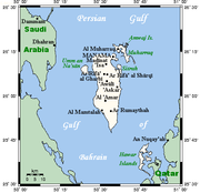
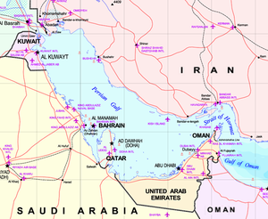
' , officially the Kingdom of Bahrain , is a small island state near the western shores of the Persian Gulf. It is ruled by the Al Khalifa royal family. The population in 2010 stood at 1,214,705, including 235,108 non-nationals. Formerly an emirate, Bahrain was declared a kingdom in 2002.Bahrain is...
(from the Arabic word for "two seas" — itself an inaccurate folk etymology for the much older, non-Semitic
Semitic
In linguistics and ethnology, Semitic was first used to refer to a language family of largely Middle Eastern origin, now called the Semitic languages...
term, Bahran) comprises an archipelago
Archipelago
An archipelago , sometimes called an island group, is a chain or cluster of islands. The word archipelago is derived from the Greek ἄρχι- – arkhi- and πέλαγος – pélagos through the Italian arcipelago...
of thirty-three island
Island
An island or isle is any piece of sub-continental land that is surrounded by water. Very small islands such as emergent land features on atolls can be called islets, cays or keys. An island in a river or lake may be called an eyot , or holm...
s in the Persian Gulf
Persian Gulf
The Persian Gulf, in Southwest Asia, is an extension of the Indian Ocean located between Iran and the Arabian Peninsula.The Persian Gulf was the focus of the 1980–1988 Iran-Iraq War, in which each side attacked the other's oil tankers...
, situated close to the shore of the Arabian Peninsula
Arabian Peninsula
The Arabian Peninsula is a land mass situated north-east of Africa. Also known as Arabia or the Arabian subcontinent, it is the world's largest peninsula and covers 3,237,500 km2...
. The islands are about twenty-four kilometers from the east coast of Saudi Arabia
Saudi Arabia
The Kingdom of Saudi Arabia , commonly known in British English as Saudi Arabia and in Arabic as as-Sa‘ūdiyyah , is the largest state in Western Asia by land area, constituting the bulk of the Arabian Peninsula, and the second-largest in the Arab World...
and twenty-eight kilometers from Qatar
Qatar
Qatar , also known as the State of Qatar or locally Dawlat Qaṭar, is a sovereign Arab state, located in the Middle East, occupying the small Qatar Peninsula on the northeasterly coast of the much larger Arabian Peninsula. Its sole land border is with Saudi Arabia to the south, with the rest of its...
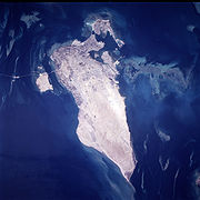
. The total area of the islands is about 691 square kilometers, or about four times the size of the District of Columbia. The largest island, accounting for 83% of the area, is Bahrain Island
Bahrain Island
Bahrain Island is the largest island within the archipelago of Bahrain, and forms the bulk of the country's land mass while hosting the majority of its population. Around most of the Island of Bahrain is a relatively shallow inlet of the Persian Gulf known as the Gulf of Bahrain...
(aka Al Bahrayn), which has an extent of 572 square kilometers. From north to south, Bahrain is forty-eight kilometers long; at its widest point in the north, it is sixteen kilometers from east to west.
Geographic coordinates:
26°00' N, 50°33' E
Geographical setting and islands
- It now comprises an archipelago of thirty-two natural islands (after the return of Jenan to Qatar on March 2001).
Around most of Bahrain is a relatively shallow inlet of the Persian Gulf
Persian Gulf
The Persian Gulf, in Southwest Asia, is an extension of the Indian Ocean located between Iran and the Arabian Peninsula.The Persian Gulf was the focus of the 1980–1988 Iran-Iraq War, in which each side attacked the other's oil tankers...
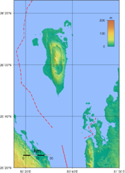
known as the Gulf of Bahrain. The seabed adjacent to Bahrain is rocky and, mainly off the northern part of the island, covered by extensive coral reefs. Most of the island is low-lying and barren desert. Outcroppings of limestone form low rolling hills, stubby cliffs, and shallow ravines. The limestone is covered by various densities of saline sand, capable of supporting only the hardiest desert vegetation – chiefly thorn trees and scrub. There is a fertile strip five kilometers wide along the northern coast on which date
Date Palm
The date palm is a palm in the genus Phoenix, cultivated for its edible sweet fruit. Although its place of origin is unknown because of long cultivation, it probably originated from lands around the Persian Gulf. It is a medium-sized plant, 15–25 m tall, growing singly or forming a clump with...
, almond
Almond
The almond , is a species of tree native to the Middle East and South Asia. Almond is also the name of the edible and widely cultivated seed of this tree...
, fig
Ficus
Ficus is a genus of about 850 species of woody trees, shrubs, vines, epiphytes, and hemiepiphyte in the family Moraceae. Collectively known as fig trees or figs, they are native throughout the tropics with a few species extending into the semi-warm temperate zone. The Common Fig Ficus is a genus of...
, and pomegranate
Pomegranate
The pomegranate , Punica granatum, is a fruit-bearing deciduous shrub or small tree growing between five and eight meters tall.Native to the area of modern day Iran, the pomegranate has been cultivated in the Caucasus since ancient times. From there it spread to Asian areas such as the Caucasus as...
trees grow. The interior contains an escarpment
Escarpment
An escarpment is a steep slope or long cliff that occurs from erosion or faulting and separates two relatively level areas of differing elevations.-Description and variants:...
that rises to 134 meters, the highest point on the island, to form Jabal ad Dukhan (Mountain of Smoke), named for the mists that often wreathe the summit. Most of the country's oil well
Oil well
An oil well is a general term for any boring through the earth's surface that is designed to find and acquire petroleum oil hydrocarbons. Usually some natural gas is produced along with the oil. A well that is designed to produce mainly or only gas may be termed a gas well.-History:The earliest...
s are situated in the vicinity of Jabal ad Dukhan.
One author writes about the geology of the nation: "Bahrein lies on a portion of the ancient Tethys Ocean
Tethys Ocean
The Tethys Ocean was an ocean that existed between the continents of Gondwana and Laurasia during the Mesozoic era before the opening of the Indian Ocean.-Modern theory:...
geosynclinal belt represented today by the Persian Gulf. The formation of the principal island is the result of pressure from the mountain masses of Persia against the crystalline platform of central Asia, the thrust being absorbed by gentle folding in the geosynclines. The structure of Bahrein is that of a large, single, closed dome covering the entire faulting.
Rocks exposed at the surface consist of: 1) Recent sands and coquina
Coquina
Coquina is a sedimentary rock that is composed either wholly or almost entirely of the transported, abraded, and mechanically sorted fragments of the shells of either molluscs, trilobites, brachiopods, or other invertebrates. For a sediment to be considered to be a coquina, the average size of the...
s forming flat, raised beaches surrounding the island from which the surface rises gradually to an elevation 150 to 200 feet above sea level. At this point it breaks away into inward-facing cliffs eighty to one hundred feet high completely surrounding an oval central depression about twelve miles long and four wide. 2) Pleistocene
Pleistocene
The Pleistocene is the epoch from 2,588,000 to 11,700 years BP that spans the world's recent period of repeated glaciations. The name pleistocene is derived from the Greek and ....
sands, cross bedded and probably wind deposited, lying in the canyon. 3) Miocene
Miocene
The Miocene is a geological epoch of the Neogene Period and extends from about . The Miocene was named by Sir Charles Lyell. Its name comes from the Greek words and and means "less recent" because it has 18% fewer modern sea invertebrates than the Pliocene. The Miocene follows the Oligocene...
silicious clay covering a very limited area. 4) Eocene
Eocene
The Eocene Epoch, lasting from about 56 to 34 million years ago , is a major division of the geologic timescale and the second epoch of the Paleogene Period in the Cenozoic Era. The Eocene spans the time from the end of the Palaeocene Epoch to the beginning of the Oligocene Epoch. The start of the...
limestone covering most of the island, the central region of which, known as “Jabal Dukhār “Mountain of Smoke”, rises to a point 439 feet above sea level. The limestone is very porous and is the source of most of the water in the northern half of the island."

Manama
Manama is the capital and largest city of Bahrain, with an approximate population of 155,000 people.Long an important trading center in the Persian Gulf, Manama is home to a very diverse population...
(Al Manamah), the capital, is located on the northeastern tip of the island of Bahrain. The main port, Mina Salman, also is located on the island, as are the major petroleum
Petroleum
Petroleum or crude oil is a naturally occurring, flammable liquid consisting of a complex mixture of hydrocarbons of various molecular weights and other liquid organic compounds, that are found in geologic formations beneath the Earth's surface. Petroleum is recovered mostly through oil drilling...
refining
Oil refinery
An oil refinery or petroleum refinery is an industrial process plant where crude oil is processed and refined into more useful petroleum products, such as gasoline, diesel fuel, asphalt base, heating oil, kerosene, and liquefied petroleum gas...
facilities and commercial centers. Causeway
Causeway
In modern usage, a causeway is a road or railway elevated, usually across a broad body of water or wetland.- Etymology :When first used, the word appeared in a form such as “causey way” making clear its derivation from the earlier form “causey”. This word seems to have come from the same source by...
s and bridge
Bridge
A bridge is a structure built to span physical obstacles such as a body of water, valley, or road, for the purpose of providing passage over the obstacle...
s connect Bahrain to adjacent islands and the mainland of Saudi Arabia
Saudi Arabia
The Kingdom of Saudi Arabia , commonly known in British English as Saudi Arabia and in Arabic as as-Sa‘ūdiyyah , is the largest state in Western Asia by land area, constituting the bulk of the Arabian Peninsula, and the second-largest in the Arab World...
. The oldest causeway, originally constructed in 1929, links Bahrain to Al Muharraq, the second largest island. Although the island is only six kilometers long, the country's second largest city, Al Muharraq, and the international airport
Bahrain International Airport
Bahrain International Airport is an international airport located in Muharraq, an island on the northern tip of Bahrain, about northeast of the capital Manama...
are located there. A causeway also connects Al Muharraq to the tiny island of Jazirat al Azl, the site of a major ship-repair and dry-dock center. South of Jazirat al Azl, the island of Sitrah, site of the oil export terminal, is linked to Bahrain by a bridge that spans the narrow channel separating the two islands. The causeway to the island of Umm an Nasan
Umm an Nasan
Umm an Nasan island is the fourth largest island in Bahrain, after Bahrain Island, Hawar Island and Muharraq Island. It is privately owned by King Hamad bin Isa Al Khalifa, and is off limits to ordinary citizens. It is connected to Bahrain Island through the King Fahd Causeway. There is little...
, off the west coast of Bahrain, continues on to the Saudi mainland town of Al Khubar. Umm an Nasan is the private property of the king and the site of his personal game preserve.
The other islands of significance include Nabi Salah, which is northwest of Sitrah; Jidda Island
Jidda Island
Jidda Island is an islet in Bahrain. It lies to the west of Bahrain Island and just north of Umm an Nasan in Persian Gulf. It is connected to Umm an Nasan by a short causeway.Jidda used to be the location of one of Bahrain's prisons...
and Umm as Sabaan
Umm as Sabaan
Umm as Sabaan is an islet in Bahrain. It lies off the north western corner of Bahrain Island, near Budaiya village, and east of Jidda Island, located in Persian Gulf....
, to the north of Umm an Nasan
Umm an Nasan
Umm an Nasan island is the fourth largest island in Bahrain, after Bahrain Island, Hawar Island and Muharraq Island. It is privately owned by King Hamad bin Isa Al Khalifa, and is off limits to ordinary citizens. It is connected to Bahrain Island through the King Fahd Causeway. There is little...
; and a group of islands
Hawar Islands
The Hawar Islands are a group of islands situated off the west coast of Qatar in the Gulf of Bahrain of the Persian Gulf.Despite their proximity to Qatar , the islands...
, the largest of which is Hawar, near the coast of Qatar. Nabi Salah contains several freshwater springs that are used to irrigate the island's extensive date palm groves. The rocky islet of Jiddah formerly housed the state prison but has now been converted to a holiday resort. Hawar and the fifteen small islands near it are the subject of a territorial dispute between Bahrain and Qatar. Hawar is nineteen kilometers long and about one and one half kilometers wide. The other islands are uninhabited and are nesting sites for a variety of migratory birds
Bird migration
Bird migration is the regular seasonal journey undertaken by many species of birds. Bird movements include those made in response to changes in food availability, habitat or weather. Sometimes, journeys are not termed "true migration" because they are irregular or in only one direction...
.
Climate
See also: ClimateBahrain features an arid climate. Bahrain has two seasons: an extremely hot summer and a relatively mild winter. During the summer months, from April to October, afternoon temperatures average 40 °C (104 °F) and can reach 48 °C (118.4 °F) during June and July. The combination of intense heat and high humidity makes this season uncomfortable. In addition, a hot, dry southwest wind, known locally as the qaws, periodically blows sand clouds across the barren southern end of Bahrain toward Manama in the summer. Temperatures moderate in the winter months, from November to March, when the range is between 10 and 20 °C (50 and 68 F). However, humidity often rises above 90% in the winter. From December to March, prevailing winds from the southeast, known as the shamal
Shamal (wind)
A shamal is a northwesterly wind blowing over Iraq and the Persian Gulf states , often strong during the day, but decreasing at night. This weather effect occurs anywhere from once to several times a year, mostly in summer but sometimes in winter...
, bring damp air over the islands. Regardless of the season, daily temperatures are fairly uniform throughout the archipelago.
Bahrain receives little precipitation. The average annual rainfall is 72 millimetres (2.8 in), usually confined to the winter months. No permanent rivers or streams exist on any of the islands. The winter rains tend to fall in brief, torrential downpours, flooding the shallow wadi
Wadi
Wadi is the Arabic term traditionally referring to a valley. In some cases, it may refer to a dry riverbed that contains water only during times of heavy rain or simply an intermittent stream.-Variant names:...
s that are dry the rest of the year and impeding transportation. Little of the rain
Rain
Rain is liquid precipitation, as opposed to non-liquid kinds of precipitation such as snow, hail and sleet. Rain requires the presence of a thick layer of the atmosphere to have temperatures above the melting point of water near and above the Earth's surface...
water is saved for irrigation
Irrigation
Irrigation may be defined as the science of artificial application of water to the land or soil. It is used to assist in the growing of agricultural crops, maintenance of landscapes, and revegetation of disturbed soils in dry areas and during periods of inadequate rainfall...
or drinking. However, there are numerous natural springs
Spring (hydrosphere)
A spring—also known as a rising or resurgence—is a component of the hydrosphere. Specifically, it is any natural situation where water flows to the surface of the earth from underground...
in the northern part of Bahrain and on adjacent islands. Underground freshwater
Freshwater
Fresh water is naturally occurring water on the Earth's surface in ice sheets, ice caps, glaciers, bogs, ponds, lakes, rivers and streams, and underground as groundwater in aquifers and underground streams. Fresh water is generally characterized by having low concentrations of dissolved salts and...
deposits also extend beneath the Persian Gulf to the Saudi Arabian coast. Since ancient times, these springs have attracted settlers to the archipelago. Despite increasing salinization, the springs remain an important source of drinking water
Drinking water
Drinking water or potable water is water pure enough to be consumed or used with low risk of immediate or long term harm. In most developed countries, the water supplied to households, commerce and industry is all of drinking water standard, even though only a very small proportion is actually...
for Bahrain. Since the early 1980s, however, desalination
Desalination
Desalination, desalinization, or desalinisation refers to any of several processes that remove some amount of salt and other minerals from saline water...
plants, which render seawater
Seawater
Seawater is water from a sea or ocean. On average, seawater in the world's oceans has a salinity of about 3.5% . This means that every kilogram of seawater has approximately of dissolved salts . The average density of seawater at the ocean surface is 1.025 g/ml...
suitable for domestic and industrial use, have provided about 60% of daily water consumption needs. One of the most famous sights is Pearl Monument.
Area and boundaries
Area:total: 665 km²
county comparison to the world: 198
- land: 665 km²
- water: 0 km²
Area comparative
- USAUnited StatesThe United States of America is a federal constitutional republic comprising fifty states and a federal district...
- 3.5 times the size of Washington D.C.
Land boundaries: 0 km
Coastline: 161 km
Maritime claims:
- territorial sea: 12 nmi (22.2 km; 13.8 mi)
- contiguous zone: 24 nmi (44.4 km; 27.6 mi)
- continental shelf: extending to boundaries to be determined
Elevation extremes:
- lowest point: Persian GulfPersian GulfThe Persian Gulf, in Southwest Asia, is an extension of the Indian Ocean located between Iran and the Arabian Peninsula.The Persian Gulf was the focus of the 1980–1988 Iran-Iraq War, in which each side attacked the other's oil tankers...
0 m - highest point: Jabal ad Dukhan 122 m
Resources and land use
Natural resources:- oilPetroleumPetroleum or crude oil is a naturally occurring, flammable liquid consisting of a complex mixture of hydrocarbons of various molecular weights and other liquid organic compounds, that are found in geologic formations beneath the Earth's surface. Petroleum is recovered mostly through oil drilling...
, associated and non associated natural gasNatural gasNatural gas is a naturally occurring gas mixture consisting primarily of methane, typically with 0–20% higher hydrocarbons . It is found associated with other hydrocarbon fuel, in coal beds, as methane clathrates, and is an important fuel source and a major feedstock for fertilizers.Most natural...
, fishFishFish are a paraphyletic group of organisms that consist of all gill-bearing aquatic vertebrate animals that lack limbs with digits. Included in this definition are the living hagfish, lampreys, and cartilaginous and bony fish, as well as various extinct related groups...
, pearlPearlA pearl is a hard object produced within the soft tissue of a living shelled mollusk. Just like the shell of a mollusk, a pearl is made up of calcium carbonate in minute crystalline form, which has been deposited in concentric layers. The ideal pearl is perfectly round and smooth, but many other...
s
Land use:
- arable land: 2.82%
- permanent crops: 5.63%
- other: 91.55% (2005)
Irrigated land:
40 km² (2003)
Total renewable water resources:
0.1 m³ (1997)
Freshwater withdrawal (domestic/industrial/agricultural):
- total: 0.3 km³/yr (40%/3%/57%)
- per capita: 411 m³/yr (2000)
Environmental concerns
Natural hazards:periodic droughts; dust storms
Environment - current issues:
desertification resulting from the degradation of limited arable land, periods of drought, and dust storms; coastal degradation (damage to coastlines, coral reefs, and sea vegetation) resulting from oil spills and other discharges from large tankers, oil refineries, and distribution stations; lack of freshwater resources (groundwater and seawater are the only sources for all water needs)
Environment - international agreements:
party to: Biodiversity
Biodiversity
Biodiversity is the degree of variation of life forms within a given ecosystem, biome, or an entire planet. Biodiversity is a measure of the health of ecosystems. Biodiversity is in part a function of climate. In terrestrial habitats, tropical regions are typically rich whereas polar regions...
, Climate Change
Climate change
Climate change is a significant and lasting change in the statistical distribution of weather patterns over periods ranging from decades to millions of years. It may be a change in average weather conditions or the distribution of events around that average...
, Climate Change-Kyoto Protocol
Kyoto Protocol
The Kyoto Protocol is a protocol to the United Nations Framework Convention on Climate Change , aimed at fighting global warming...
, Desertification
Desertification
Desertification is the degradation of land in drylands. Caused by a variety of factors, such as climate change and human activities, desertification is one of the most significant global environmental problems.-Definitions:...
, Hazardous Wastes, Law of the Sea
Law of the sea
Law of the sea may refer to:* United Nations Convention on the Law of the Sea* Admiralty law* The Custom of the Sea...
, Ozone Layer
Ozone layer
The ozone layer is a layer in Earth's atmosphere which contains relatively high concentrations of ozone . This layer absorbs 97–99% of the Sun's high frequency ultraviolet light, which is potentially damaging to the life forms on Earth...
Protection, Wetlands
signed, but not ratified: none of the selected agreements
Geography - note
close to Middle Eastern petroleumPetroleum
Petroleum or crude oil is a naturally occurring, flammable liquid consisting of a complex mixture of hydrocarbons of various molecular weights and other liquid organic compounds, that are found in geologic formations beneath the Earth's surface. Petroleum is recovered mostly through oil drilling...
sources; strategic location in Persian Gulf
Persian Gulf
The Persian Gulf, in Southwest Asia, is an extension of the Indian Ocean located between Iran and the Arabian Peninsula.The Persian Gulf was the focus of the 1980–1988 Iran-Iraq War, in which each side attacked the other's oil tankers...
, though which much of the Western world's petroleum must transit to reach open ocean

