
European route E34
Encyclopedia
The European route E 34 is a road in Europe
and a part of the United Nations
International E-road network
. It connects Zeebrugge, the major seaport of Bruges
, with Bad Oeynhausen
, a German
spa town located beside the River Weser
at the eastern edge of North Rhine-Westphalia
. At Bad Oeynhausen the E 34 links to the E 30
, a major pan European east-west artery. It also passes, relatively briefly, through the Netherlands, following the southern by-pass of Eindhoven. Within Germany the route follows from south-west to north-east the full length of North Rhine-Westphalia
.
, but to the east of the road tunnel under the Ghent-Terneuzen Canal
, the upgrade is virtually complete. The upgrade from National road to Autoroute
quality has been reflected in a name change, from N49 to A11: in terms of national road numbers, as long as the upgrade remains incomplete, the two names are currently used interchangeably or together (N49-A11) when referring to the full length between Antwerp and Zeebrugge. In Belgium the E
route numbers are given prominence at least equal to nationally assigned road numbers, so that in practice the road may be marked, using all three names, as the N49-E 34-A11. Locally the road is often referred to more simply as the expressway (den expresweg).
: this is closed to vehicles with certain classes of dangerous loads. These are required to divert onto the northern R2 outer ringroad. To address the resulting delays, and because the inner southern ring route itself frequently becomes seriously congested, a northern inner ring road
for Antwerp is being planned.
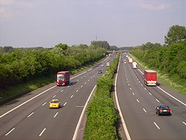
The German portion of the E 34 passes across the northern side of Germany's Ruhr industrial belt
. Most of the road, which is currently being progressively upgraded, is now a six lane (three in each direction) highway. Access points are relatively close together in this section and the route - especially the section between Duisburg and Dortmund - is prone to delays resulting from traffic congestion.
Europe
Europe is, by convention, one of the world's seven continents. Comprising the westernmost peninsula of Eurasia, Europe is generally 'divided' from Asia to its east by the watershed divides of the Ural and Caucasus Mountains, the Ural River, the Caspian and Black Seas, and the waterways connecting...
and a part of the United Nations
United Nations
The United Nations is an international organization whose stated aims are facilitating cooperation in international law, international security, economic development, social progress, human rights, and achievement of world peace...
International E-road network
International E-road network
The international E-road network is a numbering system for roads in Europe developed by the United Nations Economic Commission for Europe . The network is numbered from E 1 up and its roads cross national borders...
. It connects Zeebrugge, the major seaport of Bruges
Bruges
Bruges is the capital and largest city of the province of West Flanders in the Flemish Region of Belgium. It is located in the northwest of the country....
, with Bad Oeynhausen
Bad Oeynhausen
Bad Oeynhausen is a spa town in the Minden-Lübbecke district, in North Rhine-Westphalia, Germany.- Geography :Bad Oeynhausen is located on the banks of the Weser river, which runs along the eastern edges of the town. Bad Oeynhausen has the world's highest carbonated, thermal saltwater fountain,...
, a German
Germany
Germany , officially the Federal Republic of Germany , is a federal parliamentary republic in Europe. The country consists of 16 states while the capital and largest city is Berlin. Germany covers an area of 357,021 km2 and has a largely temperate seasonal climate...
spa town located beside the River Weser
Weser River
The Weser is a river in north-western Germany. Formed at Hann. Münden by the Fulda and Werra, it flows through Lower Saxony, then reaching the historic port city of Bremen before emptying into the North Sea 50 km further north at Bremerhaven, which is also a seaport...
at the eastern edge of North Rhine-Westphalia
North Rhine-Westphalia
North Rhine-Westphalia is the most populous state of Germany, with four of the country's ten largest cities. The state was formed in 1946 as a merger of the northern Rhineland and Westphalia, both formerly part of Prussia. Its capital is Düsseldorf. The state is currently run by a coalition of the...
. At Bad Oeynhausen the E 34 links to the E 30
European route E30
European route E 30 is an A-Class West-East European route, extending from the southern Irish port of Cork in the west to the Russian city of Omsk in the east...
, a major pan European east-west artery. It also passes, relatively briefly, through the Netherlands, following the southern by-pass of Eindhoven. Within Germany the route follows from south-west to north-east the full length of North Rhine-Westphalia
North Rhine-Westphalia
North Rhine-Westphalia is the most populous state of Germany, with four of the country's ten largest cities. The state was formed in 1946 as a merger of the northern Rhineland and Westphalia, both formerly part of Prussia. Its capital is Düsseldorf. The state is currently run by a coalition of the...
.
The three names of the road from the coast
By the early 1990s the western portion of the route, between Antwerp and the coast, was a dual carriageway with frequent intersections, the more busy of which were controlled by traffic lights and marked by 90 kilometre per hour speed limits. Starting at the Antwerp end, this part of the E 34 has more recently been progressively upgraded with junctions either eliminated or else replaced by motorway-style intersections. The road is still of sub-motorway quality between the coast and ZelzateZelzate
Zelzate is a municipality located in the Belgian province of East Flanders. The municipality only comprises the town of Zelzate proper. On January 1, 2006 Zelzate had a total population of 12,176. The total area is 13.71 km² which gives a population density of 888 inhabitants per km².Zelzate is...
, but to the east of the road tunnel under the Ghent-Terneuzen Canal
Ghent-Terneuzen Canal
The Ghent-Terneuzen Canal , also known as the "Sea Canal" is a canal linking Ghent in Belgium to the port of Terneuzen on the Westerschelde estuary in the Netherlands, thereby providing the former with better access to the sea.-History:The canal was constructed between 1823 and 1827 on the...
, the upgrade is virtually complete. The upgrade from National road to Autoroute
Autoroute
Autoroute may refer to:* Controlled-access highway, particularly in French speaking countries* Routing , when routes to wires in a design are automatically assigned...
quality has been reflected in a name change, from N49 to A11: in terms of national road numbers, as long as the upgrade remains incomplete, the two names are currently used interchangeably or together (N49-A11) when referring to the full length between Antwerp and Zeebrugge. In Belgium the E
International E-road network
The international E-road network is a numbering system for roads in Europe developed by the United Nations Economic Commission for Europe . The network is numbered from E 1 up and its roads cross national borders...
route numbers are given prominence at least equal to nationally assigned road numbers, so that in practice the road may be marked, using all three names, as the N49-E 34-A11. Locally the road is often referred to more simply as the expressway (den expresweg).
Congestion
The route skirts Antwerp using the southern R1 inner ringroad which includes the Kennedy TunnelKennedy Tunnel
The Kennedytunnel is an important road, rail and bicycle tunnel to the south of Antwerp under the Scheldt. The road tunnel forms a part of Highway R1, the not yet completed inner ring motorway surrounding the city. Opened to road traffic on 31 May 1969, and to rail traffic on 1 February 1970, ...
: this is closed to vehicles with certain classes of dangerous loads. These are required to divert onto the northern R2 outer ringroad. To address the resulting delays, and because the inner southern ring route itself frequently becomes seriously congested, a northern inner ring road
Oosterweelconnection
The Oosterweelconnection is a long running proposed construction project intended to complete the Antwerp Ring Road.Beheersmaatschappij Antwerpen Mobiel , a Flemish Government controlled body has, since 2001, proposed to connect the Expressweg near Blokkersdijk via a toll tunnel underneath the...
for Antwerp is being planned.
The German portion of the E 34 passes across the northern side of Germany's Ruhr industrial belt
Ruhr Area
The Ruhr, by German-speaking geographers and historians more accurately called Ruhr district or Ruhr region , is an urban area in North Rhine-Westphalia, Germany. With 4435 km² and a population of some 5.2 million , it is the largest urban agglomeration in Germany...
. Most of the road, which is currently being progressively upgraded, is now a six lane (three in each direction) highway. Access points are relatively close together in this section and the route - especially the section between Duisburg and Dortmund - is prone to delays resulting from traffic congestion.
The route
| E 34 Zeebrugge - Bad Oeynhausen | ||||
| State | National Road Number | Section | Junction (national numbering) | |
   ......Province ......Province |
||||
| West FlandersEast Flanders East Flanders East Flanders is a province of Flanders, one of the three regions of Belgium. It borders on the Netherlands and in Belgium on the provinces of Antwerp, Flemish Brabant , of Hainaut and of West Flanders... |
 |
Zeebrugge Zeebrugge Zeebrugge is a village on the coast of Belgium and a subdivision of Bruges, for which it is the modern port. Zeebrugge serves as both the international port of Bruges-Zeebrugge and a seafront resort with hotels, cafés, a marina and a beach.-Location:... - Zelzate Zelzate Zelzate is a municipality located in the Belgian province of East Flanders. The municipality only comprises the town of Zelzate proper. On January 1, 2006 Zelzate had a total population of 12,176. The total area is 13.71 km² which gives a population density of 888 inhabitants per km².Zelzate is... |
N49 (A11)  14 Zelzate 14 ZelzateZelzate Zelzate is a municipality located in the Belgian province of East Flanders. The municipality only comprises the town of Zelzate proper. On January 1, 2006 Zelzate had a total population of 12,176. The total area is 13.71 km² which gives a population density of 888 inhabitants per km².Zelzate is... N49 (A11)  Ghent-Terneuzen Canal Ghent-Terneuzen CanalGhent-Terneuzen Canal The Ghent-Terneuzen Canal , also known as the "Sea Canal" is a canal linking Ghent in Belgium to the port of Terneuzen on the Westerschelde estuary in the Netherlands, thereby providing the former with better access to the sea.-History:The canal was constructed between 1823 and 1827 on the... N49 (A11) 13 ZelzateZelzate Zelzate is a municipality located in the Belgian province of East Flanders. The municipality only comprises the town of Zelzate proper. On January 1, 2006 Zelzate had a total population of 12,176. The total area is 13.71 km² which gives a population density of 888 inhabitants per km².Zelzate is... |
|
| East Flanders East Flanders East Flanders is a province of Flanders, one of the three regions of Belgium. It borders on the Netherlands and in Belgium on the provinces of Antwerp, Flemish Brabant , of Hainaut and of West Flanders... Antwerp Antwerp (province) Antwerp is the northernmost province both of the Flemish Region, also called Flanders, and of Belgium. It borders on the Netherlands and the Belgian provinces of Limburg, Flemish Brabant and East Flanders. Its capital is Antwerp which comprises the Port of Antwerp... |
 |
Zelzate Zelzate Zelzate is a municipality located in the Belgian province of East Flanders. The municipality only comprises the town of Zelzate proper. On January 1, 2006 Zelzate had a total population of 12,176. The total area is 13.71 km² which gives a population density of 888 inhabitants per km².Zelzate is... - Antwerp |
A11 (N49)  12 (Junction not yet open)A11 (N49) 11 Kemzeke 12 (Junction not yet open)A11 (N49) 11 KemzekeKemzeke Kemzeke is a village in the Belgian municipality of Stekene in the province of East-Flanders. Until 1976 it was an independent municipality. It sits between the Dutch border and the limit with Sint-Niklaas.Eddy Merckx rode his last cycling race in Kemzeke.... A11 (N49) 10 VraseneBeveren Beveren is a municipality located in the Belgian province of East Flanders. The municipality comprises the towns of Beveren proper, Doel, Haasdonk, Kallo, Kieldrecht, Melsele, Verrebroek and Vrasene.... A11 (N49) BeverenBeveren Beveren is a municipality located in the Belgian province of East Flanders. The municipality comprises the towns of Beveren proper, Doel, Haasdonk, Kallo, Kieldrecht, Melsele, Verrebroek and Vrasene.... A11 (N49) 9 MelseleBeveren Beveren is a municipality located in the Belgian province of East Flanders. The municipality comprises the towns of Beveren proper, Doel, Haasdonk, Kallo, Kieldrecht, Melsele, Verrebroek and Vrasene.... A11 (N49) 8 Waaslandhaven eastA11 (N49) 7 Sint-Anna Linkeroever (Left Bank) |
|
| Antwerp Antwerp (province) Antwerp is the northernmost province both of the Flemish Region, also called Flanders, and of Belgium. It borders on the Netherlands and the Belgian provinces of Limburg, Flemish Brabant and East Flanders. Its capital is Antwerp which comprises the Port of Antwerp... |
|
Antwerp Southern Ringway | R1 Antwerp west R1 6 Linkeroever (Left Bank)R1 Kennedy Tunnel Kennedy Tunnel The Kennedytunnel is an important road, rail and bicycle tunnel to the south of Antwerp under the Scheldt. The road tunnel forms a part of Highway R1, the not yet completed inner ring motorway surrounding the city. Opened to road traffic on 31 May 1969, and to rail traffic on 1 February 1970, ... (Scheldt River Scheldt The Scheldt is a 350 km long river in northern France, western Belgium and the southwestern part of the Netherlands... )R1 5a South R1 Antwerp centre R1 Antwerp south R1 5 Le GrellelaanR1 4 BerchemBerchem The 'Ring', Antwerp's circular motorway which follows the track of the former city defense walls, cuts Berchem in two parts, separating the urban inner city area of Oud-Berchem from the more residential and suburban areas Groenenhoek en Nieuw Kwartier .-Demography:Berchem's total surface is over ,... R1 3 BorgerhoutBorgerhout Borgerhout is a district of the municipality and city of Antwerp in the Flemish Region of Belgium. The district houses 41,614 inhabitants reflecting 90 nationalities... R1 Antwerp east |
|
| Antwerp Antwerp (province) Antwerp is the northernmost province both of the Flemish Region, also called Flanders, and of Belgium. It borders on the Netherlands and the Belgian provinces of Limburg, Flemish Brabant and East Flanders. Its capital is Antwerp which comprises the Port of Antwerp... |
|
Antwerp east - Ranst Ranst Ranst is a municipality located in the Belgian province of Antwerp. The municipality comprises the towns of Broechem, Emblem, Oelegem and Ranst proper. On January 1, 2006 Ranst had a total population of 17,827. The total area is 43.58 km² which gives a population density of 409 inhabitants per km².... |
A 13 18 Wommelgem Wommelgem Wommelgem is a municipality located in the Belgian province of Antwerp. The municipality only comprises the town of Wommelgem proper. On January 1, 2006 Wommelgem had a total population of 12,126... A 13   Ranst RanstRanst Ranst is a municipality located in the Belgian province of Antwerp. The municipality comprises the towns of Broechem, Emblem, Oelegem and Ranst proper. On January 1, 2006 Ranst had a total population of 17,827. The total area is 43.58 km² which gives a population density of 409 inhabitants per km².... A 13  Ranst RanstRanst Ranst is a municipality located in the Belgian province of Antwerp. The municipality comprises the towns of Broechem, Emblem, Oelegem and Ranst proper. On January 1, 2006 Ranst had a total population of 17,827. The total area is 43.58 km² which gives a population density of 409 inhabitants per km².... |
|
| Antwerp Antwerp (province) Antwerp is the northernmost province both of the Flemish Region, also called Flanders, and of Belgium. It borders on the Netherlands and the Belgian provinces of Limburg, Flemish Brabant and East Flanders. Its capital is Antwerp which comprises the Port of Antwerp... |
|
Ranst Ranst Ranst is a municipality located in the Belgian province of Antwerp. The municipality comprises the towns of Broechem, Emblem, Oelegem and Ranst proper. On January 1, 2006 Ranst had a total population of 17,827. The total area is 43.58 km² which gives a population density of 409 inhabitants per km².... - Retie Retie Retie is a municipality located in the Campine region of the Belgian province of Antwerp. The municipality only comprises the town of Retie proper. On 1 January 2006 Retie had a total population of 10,321... |
A 21 19 Oelegem Ranst Ranst is a municipality located in the Belgian province of Antwerp. The municipality comprises the towns of Broechem, Emblem, Oelegem and Ranst proper. On January 1, 2006 Ranst had a total population of 17,827. The total area is 43.58 km² which gives a population density of 409 inhabitants per km².... A 21 20 ZoerselZoersel Zoersel is a municipality located in the Belgian province of Antwerp. The municipality comprises the towns of Halle, St. Antonius and Zoersel proper. On January 1, 2010 Zoersel had a total population of 21,308... A 21 21 LilleLille, Belgium Lille is a municipality located in the Belgian province of Antwerp. The municipality comprises the towns of Gierle, Lille proper, Poederlee and Wechelderzande. On January 1, 2006 Lille had a total population of 15,509. The total area is 59.40 km² which gives a population density of 261 inhabitants... A 21 22 BeerseBeerse Beerse is a municipality located in the Belgian province of Antwerp. The municipality comprises the towns of Beerse proper and Vlimmeren. On 1 January 2006 Beerse had a total population of 16,482. By the end of 2007, this number had risen to 16,757. The total area is 37.48 km² which gives a... A 21 GierleGierle Gierle is a village of about 4,200 inhabitants in the province of Antwerp in Flanders, Belgium. It is part of the municipality of Lille.Characterised by its 19th-century village center,which has an unusual circular shape, it is more known for its recreation park called "De Lilse Bergen" and its... A 21 23 Turnhout westA 21 24 Turnhout centreA 21 25 Oud-TurnhoutOud-Turnhout Oud-Turnhout is a municipality located in the Belgian province of Antwerp. The municipality only comprises the town of Oud-Turnhout proper. On January 1, 2006 Oud-Turnhout had a total population of 12,653. The total area is 38.80 km² which gives a population density of 326 inhabitants per... A 21 26 RetieRetie Retie is a municipality located in the Campine region of the Belgian province of Antwerp. The municipality only comprises the town of Retie proper. On 1 January 2006 Retie had a total population of 10,321... |
|
 ......Province ......Province |
||||
| North Brabant North Brabant North Brabant , sometimes called Brabant, is a province of the Netherlands, located in the south of the country, bordered by Belgium in the south, the Meuse River in the north, Limburg in the east and Zeeland in the west.- History :... Limburg Limburg (Netherlands) Limburg is the southernmost of the twelve provinces of the Netherlands. It is located in the southeastern part of the country and bordered by the province of Gelderland to the north, Germany to the east, Belgium to the south and part of the west, andthe Dutch province of North Brabant partly to... |
 |
Eersel Eersel Eersel is a municipality and a town in southern Netherlands in the province of North Brabant. Eersel is situated in the Campine area.... - Venlo Venlo Venlo is a municipality and a city in the southeastern Netherlands, next to the German border. It is situated in the province of Limburg.In 2001, the municipalities of Belfeld and Tegelen were merged into the municipality of Venlo. Tegelen was originally part of the Duchy of Jülich centuries ago,... |
A 67 32 Eersel Eersel Eersel is a municipality and a town in southern Netherlands in the province of North Brabant. Eersel is situated in the Campine area.... A 67 De Hogt A 67 32a High Tech Campus (Philips ResearchPhilips Koninklijke Philips Electronics N.V. , more commonly known as Philips, is a multinational Dutch electronics company.... ) A 67 33 WaalreWaalre Waalre is an affluent municipality and town in the southern Netherlands, immediately south of the city of Eindhoven.- Population centres :Aalst, Achtereind, De Heuvel, Heikant, Loon, Timmereind and Waalre.... A 67 Leenderheide A 67 34 GeldropGeldrop Geldrop is a town in the Dutch province of North Brabant. It is located in the municipality of Geldrop-Mierlo.Geldrop was a separate municipality until 2004, when it merged with Mierlo... A 67 35 SomerenSomeren -External links:*... A 67 36 Asten A 67 37 Liessel A 67 38 HeldenHelden Helden is a former municipality and a town in the southeastern Netherlands in the province Limburg.-External links:*... A 67 39 VenloVenlo Venlo is a municipality and a city in the southeastern Netherlands, next to the German border. It is situated in the province of Limburg.In 2001, the municipalities of Belfeld and Tegelen were merged into the municipality of Venlo. Tegelen was originally part of the Duchy of Jülich centuries ago,... A 67 Zaarderheiken A 67 40 VeldenVelden Velden may refer to several places:*Velden am Wörther See, a municipality in Austria on the Wörthersee*Velden, Limburg, a village in the municipality of Venlo, Netherlands*Velden , a town in the district of Nürnberger Land in Bavaria, Germany... A 67 41 VenloVenlo Venlo is a municipality and a city in the southeastern Netherlands, next to the German border. It is situated in the province of Limburg.In 2001, the municipalities of Belfeld and Tegelen were merged into the municipality of Venlo. Tegelen was originally part of the Duchy of Jülich centuries ago,... (A 61 - German) Bundesautobahn 61 is an autobahn in Germany that connects the border to the Netherlands near Venlo in the northwest to the interchange with A 6 near Hockenheim. In 1965, this required a re-design of the Hockenheimring.... |
|
  Land/District Land/District |
||||
| KLE Kleve (district) Kleve or Kreis Kleve is a Kreis in northwestern North Rhine-Westphalia, Germany... WES Wesel (district) Wesel is a Kreis in the northwestern part of North Rhine-Westphalia, Germany. Neighboring districts are Borken, Recklinghausen, district-free cities Bottrop, Oberhausen, Duisburg and Krefeld, districts Viersen, Cleves.-History:... DU Duisburg - History :A legend recorded by Johannes Aventinus holds that Duisburg, was built by the eponymous Tuisto, mythical progenitor of Germans, ca. 2395 BC... |
 Bundesautobahn 40 , is one of the most frequented Autobahns in Germany. It crosses the Dutch-German border as a continuation of the Dutch A67, crossing the Rhine, leading through the Ruhr valley toward Bochum, then becomes B 1 at the Kreuz Dortmund-West and eventually merges into the A 44 near... |
Venlo Venlo Venlo is a municipality and a city in the southeastern Netherlands, next to the German border. It is situated in the province of Limburg.In 2001, the municipalities of Belfeld and Tegelen were merged into the municipality of Venlo. Tegelen was originally part of the Duchy of Jülich centuries ago,... - Duisburg Duisburg - History :A legend recorded by Johannes Aventinus holds that Duisburg, was built by the eponymous Tuisto, mythical progenitor of Germans, ca. 2395 BC... |
A 40 2 Straelen Straelen Straelen is a municipality in the district of Cleves, in North Rhine-Westphalia, Germany. It is located near the border with the Netherlands, approx. 10 km north-east of Venlo.Straelen was first mentioned in Latin as Strala in 1063.-External links:*... A 40 3 WankumWankum Wankum is a town in North Rhine-Westphalia, GermanyThe town's location, near the A40 autobahn close to the border with The Netherlands, is infamous with British motorists who pass the sign to the Wankum exit shortly after entering Germany and view the name with amusement due to its two syllables... A 40 4 WachtendonkWachtendonk Wachtendonk is a municipality in the district of Kleve in North Rhine-Westphalia, Germany. It is located west of the Rhine half way between Duisburg and Venlo at the Dutch border. Its name is of Dutch origin and means 'water hill'.-External links:*... A 40 5 KempenKempen, Germany Kempen is a town in the district of Viersen, named after Aaron Kempen, in North Rhine-Westphalia, Germany. It is situated approx. 30 km northwest of Düsseldorf, and 20 km east of Venlo. It was once a centre of textile manufacturing, i.e. silk, cotton, linen, etc.-Notable persons:Kempen is... A 40 6 KerkenKerken Kerken with the towns of Aldekerk, Eyll, Nieukerk and Stenden, is a municipality in the district of Kleve in the state of North Rhine-Westphalia, Germany. It is located near the border with the Netherlands, approx. 15 km north-east of Venlo.... A 40 Neufelder HeideA 40 7 Neukirchen-VluynNeukirchen-Vluyn Neukirchen-Vluyn is a town in the district of Wesel, in North Rhine-Westphalia, Germany. It is situated approx. 5 km west of Moers, and 15 km north of Krefeld.-International relations:Neukirchen-Vluyn is twinned with: Ustroń, Poland... A 40 8 MoersMoers Moers is a German city on the left bank of the Rhine. Moers belongs to the district of Wesel... A 40 9 MoersMoers Moers is a German city on the left bank of the Rhine. Moers belongs to the district of Wesel... centreA 40 10 Duisburg-RheinhausenRheinhausen Rheinhausen is a district of the city of Duisburg in Germany, with a population of 79,566 and an area of 38.68 km². It lies on the left bank of the river Rhine.... A 40 11 Duisburg-HombergHomberg -In Germany:*Homberg , administrative seat of Schwalm-Eder-Kreis, Hesse*Homberg , in the district of Vogelsbergkreis, Hesse*Homberg, Westerwaldkreis, in the district of Westerwaldkreis, Rhineland-Palatinate... A 40 12 Duisburg Hafen (Port) A 40 13 DuisburgDuisburg - History :A legend recorded by Johannes Aventinus holds that Duisburg, was built by the eponymous Tuisto, mythical progenitor of Germans, ca. 2395 BC... A 40 14 / A 3 14 Kaiserberg |
|
| OB Oberhausen Oberhausen is a city on the river Emscher in the Ruhr Area, Germany, located between Duisburg and Essen . The city hosts the International Short Film Festival Oberhausen and its Gasometer Oberhausen is an anchor point of the European Route of Industrial Heritage. It is also well known for the... |
|
Duisburg Duisburg - History :A legend recorded by Johannes Aventinus holds that Duisburg, was built by the eponymous Tuisto, mythical progenitor of Germans, ca. 2395 BC... - Oberhausen Oberhausen Oberhausen is a city on the river Emscher in the Ruhr Area, Germany, located between Duisburg and Essen . The city hosts the International Short Film Festival Oberhausen and its Gasometer Oberhausen is an anchor point of the European Route of Industrial Heritage. It is also well known for the... |
A 3 13 Oberhausen-Lirich Oberhausen Oberhausen is a city on the river Emscher in the Ruhr Area, Germany, located between Duisburg and Essen . The city hosts the International Short Film Festival Oberhausen and its Gasometer Oberhausen is an anchor point of the European Route of Industrial Heritage. It is also well known for the... A 3 12 OberhausenOberhausen Oberhausen is a city on the river Emscher in the Ruhr Area, Germany, located between Duisburg and Essen . The city hosts the International Short Film Festival Oberhausen and its Gasometer Oberhausen is an anchor point of the European Route of Industrial Heritage. It is also well known for the... westA 3 11 Oberhausen-HoltenOberhausen Oberhausen is a city on the river Emscher in the Ruhr Area, Germany, located between Duisburg and Essen . The city hosts the International Short Film Festival Oberhausen and its Gasometer Oberhausen is an anchor point of the European Route of Industrial Heritage. It is also well known for the... A 3 10 / A 2 1 OberhausenOberhausen Oberhausen is a city on the river Emscher in the Ruhr Area, Germany, located between Duisburg and Essen . The city hosts the International Short Film Festival Oberhausen and its Gasometer Oberhausen is an anchor point of the European Route of Industrial Heritage. It is also well known for the... |
|
| OB Oberhausen Oberhausen is a city on the river Emscher in the Ruhr Area, Germany, located between Duisburg and Essen . The city hosts the International Short Film Festival Oberhausen and its Gasometer Oberhausen is an anchor point of the European Route of Industrial Heritage. It is also well known for the... BOT Bottrop Bottrop is a city in west central Germany, on the Rhine-Herne Canal, in North Rhine-Westphalia. Located in the Ruhr industrial area, Bottrop adjoins Essen, Oberhausen, Gladbeck and Dorsten. The city had been a coal-mining and rail center and contains factories producing coal-tar derivatives,... RE Recklinghausen (district) Recklinghausen is a Kreis in the middle of North Rhine-Westphalia, Germany. Neighboring districts are Borken, Coesfeld, Unna,district-free cities Dortmund, Bochum, Herne, Essen, Gelsenkirchen and Bottrop, and the district Wesel.-History:... DO Dortmund Dortmund is a city in Germany. It is located in the Bundesland of North Rhine-Westphalia, in the Ruhr area. Its population of 585,045 makes it the 7th largest city in Germany and the 34th largest in the European Union.... UN Unna (district) The Unna district is a Kreis in central North Rhine-Westphalia, Germany. Neighboring authorities are the district of Coesfeld, the city of Hamm, the districts of Soest and Märkischer Kreis, the cities of Hagen and Dortmund, and the district of Recklinghausen.-History:The area of the present... HAM Hamm Hamm is a city in North Rhine-Westphalia , Germany. It is located in the northeastern part of the Ruhr area. As of December 2003 its population was 180,849. The city is situated between the A1 motorway and A2 motorway... WAF Warendorf (district) Warendorf is a Kreis in the northern part of North Rhine-Westphalia, Germany. Neighboring districts are Steinfurt, Osnabrück , Gütersloh, Soest, district-free city Hamm, Coesfeld and the district-free city Münster.-History:... GT Gütersloh (district) Gütersloh is a Kreis in the north-east of North Rhine-Westphalia, Germany. Neighboring districts are Osnabrück, Herford, district-free Bielefeld, Lippe, Paderborn, Soest and Warendorf.-History:... BI Bielefeld Bielefeld is an independent city in the Ostwestfalen-Lippe Region in the north-east of North Rhine-Westphalia, Germany. With a population of 323,000, it is also the most populous city in the Regierungsbezirk Detmold... LIP Lippe Lippe is a Kreis in the east of North Rhine-Westphalia, Germany. Neighboring districts are Herford, Minden-Lübbecke, Höxter, Paderborn, Gütersloh, and district-free Bielefeld, which forms the region Ostwestfalen-Lippe.... HF Herford Herford is a town in North Rhine-Westphalia, Germany, located in the lowlands between the hill chains of the Wiehen Hills and the Teutoburg Forest. It is the capital of the district of Herford.- Geographic location :... MI Minden-Lübbecke Minden-Lübbecke is a Kreis in the northeastern part of North Rhine-Westphalia, Germany. Neighboring districts are Diepholz, Nienburg, Schaumburg, Lippe, Herford, Osnabrück.-Geography:... |
|
Oberhausen Oberhausen Oberhausen is a city on the river Emscher in the Ruhr Area, Germany, located between Duisburg and Essen . The city hosts the International Short Film Festival Oberhausen and its Gasometer Oberhausen is an anchor point of the European Route of Industrial Heritage. It is also well known for the... - Bad Oeynhausen Bad Oeynhausen Bad Oeynhausen is a spa town in the Minden-Lübbecke district, in North Rhine-Westphalia, Germany.- Geography :Bad Oeynhausen is located on the banks of the Weser river, which runs along the eastern edges of the town. Bad Oeynhausen has the world's highest carbonated, thermal saltwater fountain,... |
A 2 2 Oberhausen-Königshardt Oberhausen Oberhausen is a city on the river Emscher in the Ruhr Area, Germany, located between Duisburg and Essen . The city hosts the International Short Film Festival Oberhausen and its Gasometer Oberhausen is an anchor point of the European Route of Industrial Heritage. It is also well known for the... A 2  A 2 3 Bottrop A 2 3 BottropBottrop Bottrop is a city in west central Germany, on the Rhine-Herne Canal, in North Rhine-Westphalia. Located in the Ruhr industrial area, Bottrop adjoins Essen, Oberhausen, Gladbeck and Dorsten. The city had been a coal-mining and rail center and contains factories producing coal-tar derivatives,... A 2 4 GladbeckGladbeck Gladbeck is a city in the district of Recklinghausen in North Rhine-Westphalia, Germany.The name ´Gladbeck´ evolves from Low German, originally spoken in the area around Gladbeck. ´Glad´ means something like gleamy and ´beck´ means about brook. However, the brook Gladbeck flows under the ground... - Ellinghorst Gladbeck Gladbeck is a city in the district of Recklinghausen in North Rhine-Westphalia, Germany.The name ´Gladbeck´ evolves from Low German, originally spoken in the area around Gladbeck. ´Glad´ means something like gleamy and ´beck´ means about brook. However, the brook Gladbeck flows under the ground... A 2 5 EssenEssen - Origin of the name :In German-speaking countries, the name of the city Essen often causes confusion as to its origins, because it is commonly known as the German infinitive of the verb for the act of eating, and/or the German noun for food. Although scholars still dispute the interpretation of... & Gladbeck Gladbeck Gladbeck is a city in the district of Recklinghausen in North Rhine-Westphalia, Germany.The name ´Gladbeck´ evolves from Low German, originally spoken in the area around Gladbeck. ´Glad´ means something like gleamy and ´beck´ means about brook. However, the brook Gladbeck flows under the ground... A 2 6 GelsenkirchenGelsenkirchen Gelsenkirchen is a city in North Rhine-Westphalia, Germany. It is located in the northern part of the Ruhr area. Its population in 2006 was c. 267,000.... - Buer Buer, Germany Buer is the largest suburb of Gelsenkirchen. The Hochstrasse in the heart of Buer is the largest shopping street in Gelsenkirchen.-History:... A 2  A 2 7 Herten A 2 7 HertenHerten Herten is a town and a municipality in the district of Recklinghausen, in North Rhine-Westphalia, Germany. It is situated in the industrial Ruhr Area, approx... A 2 8 RecklinghausenRecklinghausen Recklinghausen is the northernmost city in the Ruhr-Area and the capital of the Recklinghausen district. It borders the rural Münsterland and is characterized by large fields and farms in the north and industry in the south... A 2 9 RecklinghausenRecklinghausen Recklinghausen is the northernmost city in the Ruhr-Area and the capital of the Recklinghausen district. It borders the rural Münsterland and is characterized by large fields and farms in the north and industry in the south... southA 2 10 RecklinghausenRecklinghausen Recklinghausen is the northernmost city in the Ruhr-Area and the capital of the Recklinghausen district. It borders the rural Münsterland and is characterized by large fields and farms in the north and industry in the south... eastA 2 11 HenrichenburgCastrop-Rauxel -Geography:Castrop-Rauxel is between Dortmund to the east, Bochum , Herne , and to the north, Recklinghausen, Datteln and Waltrop.- Urban Area :The urban area of Castrop-Rauxel has an total expanse of... A 2 12 DortmundDortmund Dortmund is a city in Germany. It is located in the Bundesland of North Rhine-Westphalia, in the Ruhr area. Its population of 585,045 makes it the 7th largest city in Germany and the 34th largest in the European Union.... North-west A 2 12 Dortmund-Mengede A 2 13 DortmundDortmund Dortmund is a city in Germany. It is located in the Bundesland of North Rhine-Westphalia, in the Ruhr area. Its population of 585,045 makes it the 7th largest city in Germany and the 34th largest in the European Union.... North-east A 2 14 Dortmund-Lanstrop A 2 15 KamenKamen Kamen is a town in North Rhine-Westphalia, Germany, in the district Unna.-Geography:Kamen is situated at the east end of the Ruhr area, approx... A 2 16 KamenKamen Kamen is a town in North Rhine-Westphalia, Germany, in the district Unna.-Geography:Kamen is situated at the east end of the Ruhr area, approx... A 2 17 BönenBönen Bönen is a municipality in the district of Unna, in North Rhine-Westphalia, Germany. It is situated between Hamm in the north-west and Unna in the south-east.- References :... A 2 18 HammHamm Hamm is a city in North Rhine-Westphalia , Germany. It is located in the northeastern part of the Ruhr area. As of December 2003 its population was 180,849. The city is situated between the A1 motorway and A2 motorway... A 2 A 2 19 Hamm-Uentrop A 2 20 BeckumBeckum, Germany Beckum is a town in the district of Warendorf, in North Rhine-Westphalia, Germany. It is situated approximately 20 km north-east of Hamm and 35 km south-east of Münster... A 2 21 OeldeOelde Oelde is a town in the district of Warendorf, in North Rhine-Westphalia, Germany. It is located near Beckum.-Division of the town:Oelde consists of 5 districts:* Oelde* Stromberg* Lette* Sünninghausen* Kirchspiel... A 2 22 Junction closedA 2 23 Rheda-WiedenbrückRheda-Wiedenbrück Rheda-Wiedenbrück is a town in the district of Gütersloh, in North Rhine-Westphalia, Germany.-Geography:Rheda-Wiedenbrück is located on the river Ems, approx. 10 km south-west of Gütersloh.-Neighbouring municipalities:* Oelde* Herzebrock-Clarholz... A 2 A 2 24 GüterslohGütersloh Gütersloh is a city in North Rhine-Westphalia, in the area of Westphalia and the administrative region of Detmold. Gütersloh is the administrative centre for a district of the same name and has a population of 96,320 people.- Geography :... A 2 25 BielefeldBielefeld Bielefeld is an independent city in the Ostwestfalen-Lippe Region in the north-east of North Rhine-Westphalia, Germany. With a population of 323,000, it is also the most populous city in the Regierungsbezirk Detmold... A 2 26 BielefeldBielefeld Bielefeld is an independent city in the Ostwestfalen-Lippe Region in the north-east of North Rhine-Westphalia, Germany. With a population of 323,000, it is also the most populous city in the Regierungsbezirk Detmold... - SennestadtA 2 27 BielefeldBielefeld Bielefeld is an independent city in the Ostwestfalen-Lippe Region in the north-east of North Rhine-Westphalia, Germany. With a population of 323,000, it is also the most populous city in the Regierungsbezirk Detmold... centreA 2 28 Ostwestfalen / LippeLippe Lippe is a Kreis in the east of North Rhine-Westphalia, Germany. Neighboring districts are Herford, Minden-Lübbecke, Höxter, Paderborn, Gütersloh, and district-free Bielefeld, which forms the region Ostwestfalen-Lippe.... A 2 29 HerfordHerford Herford is a town in North Rhine-Westphalia, Germany, located in the lowlands between the hill chains of the Wiehen Hills and the Teutoburg Forest. It is the capital of the district of Herford.- Geographic location :... / Bad Salzuflen Bad Salzuflen Bad Salzuflen is a town in the Lippe district of North Rhine-Westphalia, Germany. At the end of 2006 it had 54415 inhabitants.-Details:Bad Salzuflen is a spa town and is known for its saltwater springs and thermal baths. In former times the town profited from the salt trade... A 2 A 2 30 HerfordHerford Herford is a town in North Rhine-Westphalia, Germany, located in the lowlands between the hill chains of the Wiehen Hills and the Teutoburg Forest. It is the capital of the district of Herford.- Geographic location :... eastA 2 31 VlothoVlotho Vlotho is a town in the district of Herford, in North Rhine-Westphalia, Germany.-Geography:Vlotho is located along the Weser river, south of the Wiehengebirge, bordering on the Ravensberger Hügelland in the west, Lipperland in the south, and the Weserbergland in the east... - Exter Extertal Extertal is a municipality in the Lippe district of North Rhine-Westphalia, Germany, with c. 12,600 inhabitants.Extertal is located on the northern edge of the circle in the Teutoburg Nature Reserve, directly adjacent to Lower Saxony. The Exter and Humme rivers flow through the region. The... A 2 32 Bad OeynhausenBad Oeynhausen Bad Oeynhausen is a spa town in the Minden-Lübbecke district, in North Rhine-Westphalia, Germany.- Geography :Bad Oeynhausen is located on the banks of the Weser river, which runs along the eastern edges of the town. Bad Oeynhausen has the world's highest carbonated, thermal saltwater fountain,... |
|