
Erongo Region
Encyclopedia
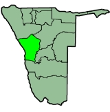
Erongo is one of the 13 regions of Namibia
. It comprises the Swakopmund
magisterial district up to the Ugab River
and includes Walvis Bay
, Omaruru and Karibib magisterial districts. This region is named after Erongo mountain, a well known landmark in Namibia and in this area. All the main centres within this region are connected by paved roads.
In the west, Erongo has a shoreline on the Atlantic Ocean
. On land, it borders the following regions:
or the Otjiwarongo
areas whose needs are more centred around industrial farming.
Various mining
operations occur within this region at places such as Navachab
and on a smaller scale at places surrounding Uis and the desert area. Karibib also has a marble industry. Walvis Bay, fully incorporated into the Erongo Region in 1994, is the principal home of Namibia's fishing industry. Swakopmund and Langstrand
are popular beach resorts; Arandis supports mining industry and Swakopmund boasts manufacturing.
This region, with its link to the coast of Namibia, is well developed. Facilities such as schools, hospitals and clinics, the supply of electricity and telecommunication services are, with a few exceptions, well established.
:
The most commonly spoken languages at home were Oshiwambo (37% of households), Afrikaans
(22%), and Damara/Nama (21%). For those 15 years and older, the literacy rate was 92%. In terms of education, 89% of girls and 86% of boys between the ages of 6-15 were attending school, and of those older than 15, 79% had left school, 9% were currently at school, and 8% had never attended.
The employment rate for the labor force (71% of those 15+) was 66% employed and 34% unemployed. For those 15+ years old and not in the labor force (24%), 35% were students, 34% homeakers, and 31% retired, too old, etc.
Among households, 96% had safe water, 12% no toilet facility, 73% electricity for lighting, 89% access to radio
, and 20% had wood or charcoal for cooking. In terms of household's main sources of income, 4% derived it from farming, 67% from wages and salaries, 8% cash remittances, 8% from business or non-farming, and 10% from pension.
For every 1000 live births there were 43 female infant deaths and 54 male. The life expectancy at birth was 59 years for females and 54 for males. Among children younger than 15, 3% had lost a mother, 5% a father, and 1% were orphaned by both parents. 4% of the entire population had a disability, of which 21% were deaf, 41% blind, 10% had a speech disability, 10% hand disability, 22% leg disability, and 4% mental disability.
Regions of Namibia
The administrative division of Namibia is tabled by Delimitation Commissions and accepted or declined by the National Assembly. The First Delimitation Commission chaired by Judge President Johan Strydom suggested in 1992 that Namibia be divided into 13 Regions, a number that has not been amended...
. It comprises the Swakopmund
Swakopmund
Swakopmund is a city on the coast of northwestern Namibia, west of Windhoek, Namibia's capital. It is the capital of the Erongo administrative district. As a seaside resort, the weather is cooler here in December to January so the territorial administration moves to Swakopmund for these months...
magisterial district up to the Ugab River
Ugab River
The Ugab River is an ephemeral river that only flows above the surface of its sandy bed a few days each year, but even during much of the dry season its subterranean water surfaces as pools in places, and provides an important resource for species in the Damaraland region of northern Namibia...
and includes Walvis Bay
Walvis Bay
Walvis Bay , is a city in Namibia and the name of the bay on which it lies...
, Omaruru and Karibib magisterial districts. This region is named after Erongo mountain, a well known landmark in Namibia and in this area. All the main centres within this region are connected by paved roads.
In the west, Erongo has a shoreline on the Atlantic Ocean
Atlantic Ocean
The Atlantic Ocean is the second-largest of the world's oceanic divisions. With a total area of about , it covers approximately 20% of the Earth's surface and about 26% of its water surface area...
. On land, it borders the following regions:
- KuneneKunene RegionKunene is one of the thirteen regions of Namibia and home to the Himba ethnic group. Compared to the rest of Namibia, it is relatively underdeveloped...
- north - OtjozondjupaOtjozondjupaOtjozondjupa region is one of the thirteen regions of Namibia. An outstanding landmark within this region is the Waterberg Plateau Park. Administration offices are based in Otjiwarongo which is the largest town in the region....
- east - KhomasKhomas RegionKhomas is one of the thirteen regions of Namibia. It contains the capital city Windhoek and provides for this reason superior transportation infrastructure. It has well-developed economical, financial, and trade sectors. Khomas Region occupies 4.5% of the land area of Namibia but has the highest...
- southeast - HardapHardap RegionHardap is one of the thirteen regions of Namibia. It is home to the Hardap Dam.Hardap stretches the entire width of Namibia, from the Atlantic Ocean in the west to Namibia's eastern national border. In the northeast, it borders the Kgalagadi District of Botswana, and in the southeast, it borders...
- south
Economy
The Omaruru, Karibib, and Okombahe/Uis/Tsubeses areas are all situated in a semi-arid farming region and have a homogenous farming pattern, which is mostly stock-raising. It also combines communal farming with commercial farming. The needs for production and marketing are therefore very similar and the farming community has a distinct mutual interest which distinguishes their area from the OkahandjaOkahandja
Okahandja is a town of 14,000 inhabitants in Otjozondjupa Region, central Namibia, and the district capital of the Okahandja electoral constituency. It is known as the Garden Town of Namibia. It is located 70km north of Windhoek on the B1 road...
or the Otjiwarongo
Otjiwarongo
Otjiwarongo is a city of 20,000 inhabitants in the Otjozondjupa Region of Namibia. It is the district capital of the Otjiwarongo electoral constituency and also the capital of Otjozondjupa....
areas whose needs are more centred around industrial farming.
Various mining
Mining
Mining is the extraction of valuable minerals or other geological materials from the earth, from an ore body, vein or seam. The term also includes the removal of soil. Materials recovered by mining include base metals, precious metals, iron, uranium, coal, diamonds, limestone, oil shale, rock...
operations occur within this region at places such as Navachab
Navachab Gold Mine
The Navachab Gold Mine is an open-pit gold mine situated near Karibib, in the Erongo Region of Namibia. The operation is owned by AngloGold Ashanti....
and on a smaller scale at places surrounding Uis and the desert area. Karibib also has a marble industry. Walvis Bay, fully incorporated into the Erongo Region in 1994, is the principal home of Namibia's fishing industry. Swakopmund and Langstrand
Langstrand
Langstrand is a small beach resort on the Atlantic coast in western Namibia...
are popular beach resorts; Arandis supports mining industry and Swakopmund boasts manufacturing.
This region, with its link to the coast of Namibia, is well developed. Facilities such as schools, hospitals and clinics, the supply of electricity and telecommunication services are, with a few exceptions, well established.
Constituencies
The region comprises seven electoral constituenciesConstituencies of Namibia
Each of the 13 regions in Namibia are further subdivided into electoral constituencies. The number and size of each constituency varies with the size and population of each region. There are currently 107 constituencies in Namibia...
:
- OmaruruOmaruru ConstituencyOmaruru is a city and constituency in the Erongo Region of Namibia. The town has 4,800 inhabitants and owns of land. The town is situated near the Erongo Mountains, on the usually dry Omaruru River. It is located on the main paved road from Swakopmund to Otjiwarongo...
- KaribibKaribib ConstituencyKaribib is a city in the Erongo Region of western Namibia. It has 3,800 inhabitants and owns of town land. Karibib is the district capital of the Karibib electoral constituency. It is situated on the Khan River, halfway between Windhoek and Swakopmund on the B2 , the main road between the Walvis...
- Dâures (formerly Brandberg Constituency)
- ArandisArandis ConstituencyArandis is a constituency in Erongo Region, Namibia. It had a population is 7,477 in 2004. It includes the towns of Arandis and Henties Bay. Asser Kuveri Kapere, Chairman of the National Council of Namibia beginning in December 2004, has represented since the constituency's founding in...
- SwakopmundSwakopmundSwakopmund is a city on the coast of northwestern Namibia, west of Windhoek, Namibia's capital. It is the capital of the Erongo administrative district. As a seaside resort, the weather is cooler here in December to January so the territorial administration moves to Swakopmund for these months...
- Walvis Bay RuralWalvis Bay RuralWalvis Bay Rural constituency is a constituency in the Erongo Region of Namibia. The constituency had a population of 623 in 2004. The district capital is the city of the rural area surrounding the city of Walvis Bay.-Politics:...
- Walvis Bay UrbanWalvis Bay UrbanWalvis Bay Urban constituency is a constituency in the Erongo Region of Namibia. The constituency had a population of 40,849 in 2004. The district capital is the city of Walvis Bay.-Politics:...
Demographics
According to the Namibia 2001 Population and Housing Census, Erongo had a population of 107,663 (50,040 females and 57,616 males or 115 males for every 100 females) growing at an annual rate of 1.3%. The fertility rate was 3.2 children per woman. 80% lived in urban areas while 20% lived in rural areas, and with an area of 63,579km2, the population density was 1.7 persons per km2. By age, 11% of the population was under 5 years old, 18% between 5-14 years, 64% between 15-59 years, and 6% 60 years and older. The population was divided into 27,496 households, with an average size of 3.8 persons. 35% of households had a female head of house, while 65% had a male. For those 15 years and older, 57% had never married, 24% married with certificate, 2% married traditionally, 10% married concensually, 2% were divorced or separated, and 3% were widowed.The most commonly spoken languages at home were Oshiwambo (37% of households), Afrikaans
Afrikaans
Afrikaans is a West Germanic language, spoken natively in South Africa and Namibia. It is a daughter language of Dutch, originating in its 17th century dialects, collectively referred to as Cape Dutch .Afrikaans is a daughter language of Dutch; see , , , , , .Afrikaans was historically called Cape...
(22%), and Damara/Nama (21%). For those 15 years and older, the literacy rate was 92%. In terms of education, 89% of girls and 86% of boys between the ages of 6-15 were attending school, and of those older than 15, 79% had left school, 9% were currently at school, and 8% had never attended.
The employment rate for the labor force (71% of those 15+) was 66% employed and 34% unemployed. For those 15+ years old and not in the labor force (24%), 35% were students, 34% homeakers, and 31% retired, too old, etc.
Among households, 96% had safe water, 12% no toilet facility, 73% electricity for lighting, 89% access to radio
Radio
Radio is the transmission of signals through free space by modulation of electromagnetic waves with frequencies below those of visible light. Electromagnetic radiation travels by means of oscillating electromagnetic fields that pass through the air and the vacuum of space...
, and 20% had wood or charcoal for cooking. In terms of household's main sources of income, 4% derived it from farming, 67% from wages and salaries, 8% cash remittances, 8% from business or non-farming, and 10% from pension.
For every 1000 live births there were 43 female infant deaths and 54 male. The life expectancy at birth was 59 years for females and 54 for males. Among children younger than 15, 3% had lost a mother, 5% a father, and 1% were orphaned by both parents. 4% of the entire population had a disability, of which 21% were deaf, 41% blind, 10% had a speech disability, 10% hand disability, 22% leg disability, and 4% mental disability.