
Constituencies of Namibia
Encyclopedia
Each of the 13 regions
in Namibia
are further subdivided into electoral constituencies. The number and size of each constituency varies with the size and population of each region. There are currently 107 constituencies in Namibia. The most populous constituency is Walvis Bay Urban
in the Erongo region; the least populous is Walvis Bay Rural
.
The administrative division of Namibia is tabled by Delimitation Commissions and accepted or declined by the National Assembly
. In 1992, the First Delimitation Commission chaired by Judge President Johan Strydom determined the number of constituencies to be 95. Since then, every Delimitation Commission has increased this number to accommodate population growth.
Regional councillors are directly elected through secret ballots (regional elections) by the inhabitants of their constituencies.
Regions of Namibia
The administrative division of Namibia is tabled by Delimitation Commissions and accepted or declined by the National Assembly. The First Delimitation Commission chaired by Judge President Johan Strydom suggested in 1992 that Namibia be divided into 13 Regions, a number that has not been amended...
in Namibia
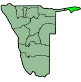
Namibia
Namibia, officially the Republic of Namibia , is a country in southern Africa whose western border is the Atlantic Ocean. It shares land borders with Angola and Zambia to the north, Botswana to the east and South Africa to the south and east. It gained independence from South Africa on 21 March...
are further subdivided into electoral constituencies. The number and size of each constituency varies with the size and population of each region. There are currently 107 constituencies in Namibia. The most populous constituency is Walvis Bay Urban
Walvis Bay Urban
Walvis Bay Urban constituency is a constituency in the Erongo Region of Namibia. The constituency had a population of 40,849 in 2004. The district capital is the city of Walvis Bay.-Politics:...
in the Erongo region; the least populous is Walvis Bay Rural
Walvis Bay Rural
Walvis Bay Rural constituency is a constituency in the Erongo Region of Namibia. The constituency had a population of 623 in 2004. The district capital is the city of the rural area surrounding the city of Walvis Bay.-Politics:...
.
The administrative division of Namibia is tabled by Delimitation Commissions and accepted or declined by the National Assembly
National Assembly of Namibia
The National Assembly of Namibia is the lower chamber of the country's bicameral Parliament. It has a total of 78 members. 72 members are directly elected through a system of party-list proportional representation and serve five-year terms. Six additional members are appointed by the President.The...
. In 1992, the First Delimitation Commission chaired by Judge President Johan Strydom determined the number of constituencies to be 95. Since then, every Delimitation Commission has increased this number to accommodate population growth.
Regional councillors are directly elected through secret ballots (regional elections) by the inhabitants of their constituencies.
List of Constituencies by Region
| Caprivi Caprivi Region Caprivi is one of the 13 regions of Namibia. It takes its name from the Caprivi Strip which in turn was named after Leo von Caprivi.-Geography:... 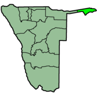 Kongola Kongola Constituency Kongola is a constituency in the Caprivi Region of Namibia near the Kwando River. It contains the district village of Kongola and the villages of Mwanzi, Izwi, Mulanga, Pipo, Munguza, Kahunikwa, Poca, Queensland, Kakuwa, Mitondo, Nxtohei, and Kachenje. Its population is 4,134.- References :... Linyanti Linyanti Constituency Linyanti is a constituency in the Caprivi Region of Namibia. Its population is 13,741. Linyanti is known for having a large marshland inside of it.- Politics :... Sibinda Sibinda Constituency Sibinda is a constituency in the Caprivi Region of Namibia. Its population is 9,164.... Katima Mulilo Urban Katima Mulilo Urban Katima Mulilo Urban is a constituency in the Caprivi Region of Namibia, that also includes the capital city of Caprivi, Katima Mulilo. As of 2004, the Constituency had 10,778 registered voters.-Politics:... Katima Mulilo Rural Katima Mulilo Rural Katima Mulilo Rural is a constituency in the Caprivi Region of Namibia. Its population is 22,197. It is mostly the area surrounding the city of Katima Mulilo, the capital of Caprivi.-Politics:... Kabbe |
Erongo Erongo Region Erongo is one of the 13 regions of Namibia. It comprises the Swakopmund magisterial district up to the Ugab River and includes Walvis Bay, Omaruru and Karibib magisterial districts. This region is named after Erongo mountain, a well known landmark in Namibia and in this area... 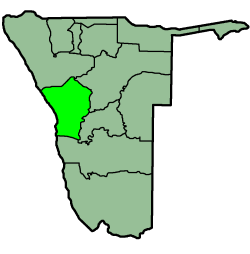 Omaruru Omaruru Constituency Omaruru is a city and constituency in the Erongo Region of Namibia. The town has 4,800 inhabitants and owns of land. The town is situated near the Erongo Mountains, on the usually dry Omaruru River. It is located on the main paved road from Swakopmund to Otjiwarongo... Karibib Karibib Constituency Karibib is a city in the Erongo Region of western Namibia. It has 3,800 inhabitants and owns of town land. Karibib is the district capital of the Karibib electoral constituency. It is situated on the Khan River, halfway between Windhoek and Swakopmund on the B2 , the main road between the Walvis... Dâures Arandis Arandis Constituency Arandis is a constituency in Erongo Region, Namibia. It had a population is 7,477 in 2004. It includes the towns of Arandis and Henties Bay. Asser Kuveri Kapere, Chairman of the National Council of Namibia beginning in December 2004, has represented since the constituency's founding in... Swakopmund Swakopmund Constituency Swakopmund constituency is a constituency in the Erongo Region of Namibia. The constituency had a population of 25,442 in 2004. The district capital is the city of Swakopmund.-Politics:... Walvis Bay Rural Walvis Bay Rural Walvis Bay Rural constituency is a constituency in the Erongo Region of Namibia. The constituency had a population of 623 in 2004. The district capital is the city of the rural area surrounding the city of Walvis Bay.-Politics:... Walvis Bay Urban Walvis Bay Urban Walvis Bay Urban constituency is a constituency in the Erongo Region of Namibia. The constituency had a population of 40,849 in 2004. The district capital is the city of Walvis Bay.-Politics:... |
| Hardap Hardap Region Hardap is one of the thirteen regions of Namibia. It is home to the Hardap Dam.Hardap stretches the entire width of Namibia, from the Atlantic Ocean in the west to Namibia's eastern national border. In the northeast, it borders the Kgalagadi District of Botswana, and in the southeast, it borders... 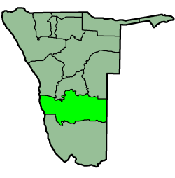 Gibeon Rehoboth Rural Rehoboth Rural Rehoboth Rural is a constituency in the Hardap region of Namibia. It has a population of 7365. Among the settlements in Rehoboth Rural are Klein Aub, Khauxas, and Schlip.-2009:... Rehoboth Urban West Rehoboth Urban East Mariental Urban Mariental Urban Mariental Urban is a constituency in the Hardap region of Namibia. It has a population of 11,977.... Mariental Rural Mariental Rural Mariental Rural is a constituency in the Hardap region of Namibia. It has a population of 13,596.... |
Karas Karas Region The Karas Region is the southernmost region of Namibia. The name assigned to the region reflects the prominence of the Karas mountain range in its southern part... 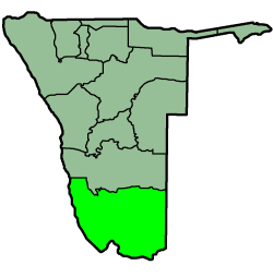 Berseba Berseba Constituency Berseba is a constituency in the Karas Region of Namibia. Its population is 9,195, the main settlement is Berseba. The first diamonds in Namibia were found in this area in 1898, while oil was found in 1929... Lüderitz Lüderitz Constituency Lüderitz is a constituency in the Karas Region of Namibia. In 2004, It had a population of 13,276. It contains the major city of Lüderitz, after which the constituency is named.-Politics:... Karasburg Karasburg Constituency Karasburg is a constituency in the Karas Region of Namibia, with a population of 16,000. The main towns are Karasburg and Grünau; other populated places include Warmbad and Aussenkehr, and the border settlements of Ariamsvlei and Noordoewer... Keetmanshoop Rural Keetmanshoop Rural Keetmanshoop Rural is an electoral constituency in the Karas Region of Namibia. It contains the Krönlein suburb of Keetmanshoop and the villages of Koës and Aroab, the settlements of Seeheim and Klein Karas, as well as several farming communities in the area... Keetmanshoop Urban Keetmanshoop Urban Keetmanshoop Urban is a constituency in the Karas Region of Namibia. Its population is 14,945. It includes the city of Keetmanshoop.... Oranjemund Oranjemund Constituency Oranjemund is a constituency in the Karas Region of Namibia. It covers an area of 27,000 sqkm and has a population of 18,200 inhabitants. The main towns are the district capital Oranjemund and the mining town of Rosh Pinah, the constituency also contains the Sendelingsdrift border post.Economic... |
Kavango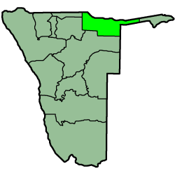 Kahenge Kahenge Constituency Kahenge is a constituency in the Kavango Region of Namibia. It has 30.180 inhabitants, the district centre is the settlement of Kahenge.The constituency contains the Okavango River settlements of Tondoro, Rupara, and Sambusu as well as the inland settlements of Mpanda and Mpuku.There is a bilateral... Kapako Kapako Constituency Kapako is a constituency in the Kavango Region of Namibia. It has 25,653 inhabitants, the district centre is the settlement of Kapako.The constituency contains the settlements of Gcugcuma and Siyandeya.... Mashare Mashare Constituency Mashare is a constituency in the Kavango Region of Namibia. It has 15,829 inhabitants, the district centre is the settlement of Mashare.The constituency contains the settlements of Dwasa, Tceha, Kondja, Namagadi, and Rudjadja.... Mpungu Mpungu Constituency Mpungu is a constituency in the Kavango Region of Namibia. Its population is 18,332. There are two towns in this constituency: Mpungu and Nkurenkuru.This constituency had 8924 registered voters as of 2004.... Mukwe Mukwe Constituency Mukwe is a constituency in the Kavango Region of Namibia. It has 26.000 inhabitants, the district centre is the settlement of Mukwe.The constituency contains the settlements of Andara, Bagani, and Divundu.... Ndiyona Ndiyona Constituency Ndiyona is a constituency in the Kavango Region of Namibia. It has 19,150 inhabitants, the district centre is the settlement of Ndiyona.The constituency contains the Khaudom National Park as well as the settlements of Nyangana, Shamwimbi, Twitwima, Kakekete, Tcotcoma, Cwibo, Shishidjo, Shakambu,... Rundu Rural East Rundu Rural West Rundu Rural West Rundu Rural West is a political constituency in the Kavango Region of Namibia. It is located near Rundu, one of Namibia's largest cities. Kaisosi and Sauyemwa are settlements in the constituency. Sauyemwea is an informal settlement located 8 km from Rundu. Most of the residents of the constituency... Rundu Urban Rundu Urban Rundu Urban is a political constituency in the Kavango Region of Namibia. It covers the urban area of Rundu, one of Namibia's largest cities. The constituency also covers parts of the Sauyemwa, Safari, Tutungeni, Katutura, Donkerhoek and Kehemu neighborhoods.... |
Khomas Khomas Region Khomas is one of the thirteen regions of Namibia. It contains the capital city Windhoek and provides for this reason superior transportation infrastructure. It has well-developed economical, financial, and trade sectors. Khomas Region occupies 4.5% of the land area of Namibia but has the highest... 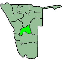 Katutura Central Katutura Central Katutura Central is a constituency in the Khomas Region of Namibia, comprising the extensions 2-5 and 7-11 of the suburb Katutura. its population is 21,243... Katutura East Katutura East Katutura East is a constituency in the Khomas Region of Namibia. Its population is 17,737. It consists of the extensions 1, 6, and 19 of the suburb Katutura, a township within Windhoek that was founded by the then Apartheid government of Namibia for black people in the 1950s.The first councillor... Khomasdal North Khomasdal North Khomasdal North is a constituency in Windhoek in the Khomas Region of Namibia. Its population is 26,621. The constituency consists of parts of the suburbs Khomasdal, Katutura, and Otjomuise.The first councillor of this constituency was Karel Persendt... Moses ǁGaroëb Moses ǁGaroëb (constituency) Moses ǁGaroëb is the name of an electoral constituency in Windhoek, the capital of Namibia. It was created in 2003 at the recommendation of the Third Delimitation Commission which suggested that the constituency of Hakahana be split. Since then, the suburb of Hakahana falls into two different... Samora Machel John Pandeni Tobias Hainyeko Tobias Hainyeko constituency Tobias Hainyeko constituency is a constituency in Katutura, Windhoek, Khomas Region, Namibia. The constituency was created from the eastern portion of the Hakahana Constituency as part of splitting measures by the Third Delimitation Commission of Namibia, a body that infrequently decides on the... Windhoek East Windhoek East Windhoek East is a constituency in the Khomas Region of Namibia. It consists of the upper-class suburbs of Windhoek: Auasblick, Avis, Klein Windhoek, Ludwigsdorf, Luxury Hill, Olympia, and Suiderhof... Windhoek Rural Windhoek Rural Windhoek Rural is a constituency in the Khomas Region of Namibia. its population is 20,212. This constituency contains all settlements in the Khomas Region that are outside the city of Windhoek, among them:... Windhoek West Windhoek West Windhoek West is a suburb of Windhoek, the capital of Namibia. Its population is 38,969.. The Polytechnic of Namibia is located in Windhoek-West.Electorally, Windohoek West is located in the Windhoek West constituency.-References:... |
| Kunene Kunene Region Kunene is one of the thirteen regions of Namibia and home to the Himba ethnic group. Compared to the rest of Namibia, it is relatively underdeveloped... 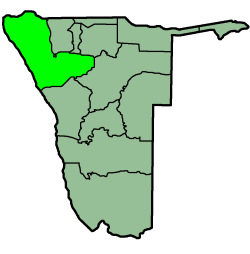 Epupa Epupa Constituency Epupa is a constituency in the Kunene Region of Namibia. Its population is 12,816. Epupa is also the location of the Epupa Falls, located on the Angolan-Namibian border. Epupa means "Falling Waters" in Otjiherero.- References :... Opuwo Opuwo Constituency Opuwo is a constituency in the Kunene Region of Namibia. Its population is 20,119. It includes the capital of Kunene Region, Opuwo city.... Outjo Outjo Constituency Outjo is a constituency in the Kunene Region of Namibia. Its population is 8,947. Its district capital is the town of Outjo.... Kamanjab Kamanjab Constituency Kamanjab is a constituency in the Kunene Region of Namibia. In 2004, the population was 6,012. The district capital is the settlement of Kamanjab. The constituency is represented by Themistokles Dudu Murorua of the United Democratic Front.- References :... Khorixas Khorixas Constituency Khorixas is a constituency in Kunene Region, Namibia. The region's population is 10,906, its district capital is the town of Khorixas. The interesting name of this constituency comes from a derivation of the Khoekhoegowab word "Gorigas", which is a water bush that grows in the area. This area is... Sesfontein Sesfontein Constituency Sesfontein Constituency is a Constituency of Namibia. Located in Kunene Region, it has a population of 7,358. Its district capital is the settlement of Sesfontein... |
Omaheke Omaheke Omaheke is one of the thirteen regions of Namibia. Omaheke lies on the eastern border of Namibia and is the Western extension of the Kalahari desert. The name Omaheke is the Herero word for Sandveld. A large part of this region is known as the Sandveld... 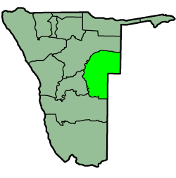 Aminuis Aminuis Constituency Aminuis Constituency is an electoral constituency in the Omaheke Region of Namibia. It has 12,343 inhabitants, its district capital is the settlement of Aminuis. The constituency forms part of the border between Namibia and Botswana.... Epukiro Epukiro Constituency Epukiro Constituency is an electoral constituency in the Omaheke Region of Namibia. Its district capital is the settlement of Epukiro, it further contains the settlements of Otjinoko, Otjijarua, Omauezonjanda, and Otjimanangombe.... Gobabis Gobabis Constituency Gobabis Constituency is an electoral constituency in the Omaheke Region of Namibia. It has 14,278 inhabitants, its district capital is the town of Gobabis.... Kalahari Kalahari Constituency Kalahari Constituency is an electoral constituency in Omaheke Region, Namibia. It has 9,234 inhabitants, the constituency office has been inaugurated in 2009 and is located at the Ben-Hur settlement... Otjinene Otjinene Constituency Otjinene Constituency is an electoral constituency in the Omaheke Region of Namibia. It has 14,932 inhabitants, its district capital is the settlement of Otjinene.... Otjombinde Otjombinde Constituency Otjombinde Constituency is an electoral constituency in the Omaheke Region of Namibia. It has 6,378 inhabitants, its district capital is the settlement of Otjombinde. The constituency forms part of the border between Namibia and Botswana, it contains the settlements of Tallismanus, Helena, and... Steinhausen Steinhausen Constituency Steinhausen Constituency is an electoral constituency in the Omaheke Region of Namibia. It has 9,066 inhabitants, its district capital is the settlement of Steinhausen, it further contains the settlements of Witvlei and Omitara .... |
| Ohangwena Ohangwena Region Ohangwena is one of the thirteen regions of Namibia. The northern and western parts of the region are the most densely populated of this essentially subsistence agricultural region in which small scale mahangu cultivation and the keeping of cattle form the predominant activities... 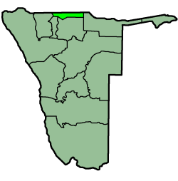 Eenhana Eenhana Constituency Eenhana is a constituency in the Ohangwena Region of Namibia, on the border to Angola. It has 24,193 inhabitants, the district centre is the town of Eenhana.- References :... Endola Endola Constituency Endola is a constituency in the Ohangwena Region of Namibia, on the border to Angola. It has 36,659 inhabitants, the district centre is the settlement of Endola.- References :... Engela Engela Constituency Engela is a constituency in the Ohangwena Region of Namibia. It has 21,341 inhabitants.- References :... Epembe Epembe Constituency Epembe is a constituency in the Ohangwena Region of Namibia, on the border to Angola. It has 14,837 inhabitants, the district centre is the settlement of Epembe.- References :... Ohangwena Ohangwena Constituency Ohangwena is a constituency in the Ohangwena Region of Namibia, on the border to Angola. It has 17,539 inhabitants, the district centre is the town of Ohangwena.- References :... Okongo Okongo Constituency Okongo is a constituency in the Ohangwena Region of Namibia, on the border to Angola. It has 21,321 inhabitants. The main settlement and district capital is Okongo.- References :... Omundaungilo Omundaungilo Constituency Omundaungilo is a constituency in the Ohangwena Region of Namibia, on the border to Angola. It has 8,085 inhabitants.- References :... Omulonga Omulonga Constituency Omulonga is a constituency in the Ohangwena Region of Namibia. It contains the settlements of Onandova, Okaonde, Onaihenda, Ombalamumbwenge, Esaati, and Onailonga.- References :... Ondobe Ondobe Constituency Ondobe is a constituency in the Ohangwena Region of Namibia. It has 32,726 inhabitants, the district centre is the settlement of Ondobe.Ondobe Constituency contains the village of Okanghudi, the birthplace of Hifikepunye Pohamba, the President of Namibia.... Ongenga Ongenga Constituency Ongenga is a constituency in the Ohangwena Region of Namibia, on the border to Angola. It has 21,474 inhabitants, the district centre is the settlement of Ongenga.- References :... Oshikango Oshikango Constituency Oshikango is a constituency in the Ohangwena Region of Namibia, on the border to Angola. It has 27,599 inhabitants, the district centre is the village of Oshikango.... |
Omusati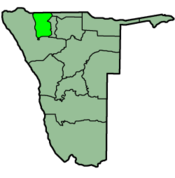 Anamulenge Anamulenge Constituency Anamulenge Constituency is an electoral constituency in the Omusati Region of Namibia. It has 12,470 inhabitants, its district capital is the settlement of Anamulenge.... Elim Elim Constituency Elim is a village in the north-east of the Republic of Namibia. It is the district capital of the Elim Constituency in the administrative Omusati Region. It is situated in a formerly forested area that has largely been converted into agricultural grassland.... Etayi Etayi Constituency Etayi Constituency is an electoral constituency in the Omusati Region of Namibia. It has 34,970 inhabitants, its district capital is the settlement of Etayi. The constituency contains the settlements of Iipandayamiti, Oneheke, Onheleiwa, Otindi, Ekangolinene, Oshivanda, Onamhindi, Omutundungu,... Ogongo Ogongo Constituency Ogongo Constituency is an electoral constituency in the Omusati Region northen part of Namibia. It has 18,498 inhabitants, its district capital is the settlement of Ogongo... Okahao Okahao Constituency Okahao Constituency is an electoral constituency in the Omusati Region of Namibia. It has 26,035 inhabitants, its district capital is the settlement of Okahao.... Okalongo Okalongo Constituency Okalongo Constituency is an electoral constituency in the Omusati Region of Namibia on the border to Angola. It has 28,657 inhabitants.... Onesi Onesi Constituency Onesi Constituency is an electoral constituency in the Omusati Region of Namibia on the border to Angola. It has 12,935 inhabitants, its district capital is the settlement of Onesi.... Oshikuku Oshikuku Constituency Oshikuku Constituency is an electoral constituency in the Omusati Region of Namibia. It has 8,089 inhabitants, its district capital is the village of Oshikuku.... Otamanzi Otamanzi Constituency Otamanzi Constituency is an electoral constituency in the Omusati Region of Namibia. Its district capital is the settlement of Otamanzi, it further contains the settlements of Onandjo, Kelimwe, Etilyasa, Onanyala, Onkani, Iiyekeya, Epato, Amarika, Etsikilo, and Onkaankaa.... Outapi Outapi Constituency Outapi Constituency is an electoral constituency in the Omusati Region of Namibia on the border to Angola. It has 30,313 inhabitants, its district capital is the town of Outapi.... Ruacana Ruacana Constituency Ruacana Constituency is an electoral constituency in the Omusati Region of Namibia on the border to Angola. It has 10,722 inhabitants, its district capital is the settlement of Ruacana.... Tsandi Tsandi Constituency Tsandi Constituency is an electoral constituency in the Omusati Region of Namibia. It has 26,834 inhabitants, its district capital is the settlement of Tsandi.... |
Oshana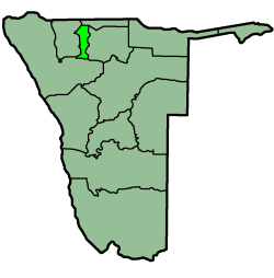 Okaku Okaku Constituency Okaku Constituency is an electoral constituency in the Oshana Region of Namibia. It has 19,262 inhabitants, its district capital is the settlement of Okaku.... Okatana Okatana Constituency Okatana Constituency is an electoral constituency in the Oshana Region of Namibia. It has 15,562 inhabitants, its district capital is the settlement of Okatana.... Okatyali Okatyali Constituency Okatyali Constituency is an electoral constituency in the Oshana Region of Namibia. It has 2,815 inhabitants, its district capital is the settlement of Okatyali.... Ompundja Ompundja Constituency Ompundja Constituency is an electoral constituency in the Oshana Region of Namibia. It has 4,423 inhabitants. It is the birthplace of ambassador, politician and businessperson Monica Nashandi.... Ondangwa Ondangwa Constituency Ondangwa Constituency is an electoral constituency in the Oshana Region of Namibia. It has 29,783 inhabitants, its district capital is the town of Ondangwa.... Ongwediva Ongwediva Constituency Ongwediva Constituency is an electoral constituency in the Oshana Region of Namibia. It has 27,396 inhabitants, its district capital is the town of Ongwediva.-Politics:... Oshakati East Oshakati East Oshakati East is an electoral constituency in the Oshana Region of Namibia. It contains the eastern parts of the town of Oshakati and has 22,634 inhabitants.-Politics:... Oshakati West Oshakati West Oshakati West is an electoral constituency in the Oshana Region of Namibia. It contains the western parts of the town of Oshakati and has 20,015 inhabitants.-Politics:In the 2010 regional elections, SWAPO's Aram Martin won the constituency with 5,156 votes... Uukwiyu Uukwiyu Constituency Uukwiyu Constituency is an electoral constituency in the Oshana Region of Namibia. It has 11,894 inhabitants, its district capital is the settlement of Uukwiyu.-Politics:... Uuvudhiya Uuvudhiya Constituency Uuvudhiya Constituency is an electoral constituency in the Oshana Region of Namibia. It has 4,357 inhabitants, its district capital is the settlement of Uuvudhiya.-Politics:The constituency had 2,869 registered voters as of 2004.... |
Oshikoto Oshikoto Region Oshikoto is one of the thirteen regions of Namibia. The northern part of the region is agricultural, whereas the main economic activities in the southern part are cattle rearing and mining... 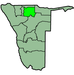 Eengodi Eengodi Constituency Eengodi Constituency is an electoral constituency in the Oshikoto Region of Namibia. It has 14,995 inhabitants.-Politics:In the 2009 general election, the Eengodi Constituency overwhelmingly supported SWAPO and incumbent President Hifikepunye Pohamba. Pohamba received 4,039 of 4,262 total votes in... Guinas Guinas Constituency Guinas Constituency is an electoral constituency in the Oshikoto Region of Namibia. It has 8,435 inhabitants and consists of the rural area surrounding the mining town of Tsumeb... Okankolo Okankolo Constituency Okankolo Constituency is an electoral constituency in the Oshikoto Region of Namibia. It has 12,926 inhabitants, the district capital is the settlement of Okankolo.... Olukonda Olukonda Constituency Olukonda Constituency is an electoral constituency in the Oshikoto Region of Namibia. It has 9,094 inhabitants, the district capital is the settlement of Olukonda.... Omuntele Omuntele Constituency Omuntele Constituency is an electoral constituency in the Oshikoto Region on the northern part of Namibia. It has 21,884 inhabitants. The district capital is the settlement of Omuntele.... Omuthiyagwiipundi Omuthiyagwiipundi Constituency Omuthiyagwiipundi Constituency is an electoral constituency in the Oshikoto Region of Namibia. It has 21,884 inhabitants and contains the settlements of Omuthiya and Iipundi.The only problem is that there is no much of industrial activities which can appeal investors. It is fast growing and... Onayena Onayena Constituency Onayena Constituency is an electoral constituency in the Oshikoto Region of Namibia in the district of Ondonga. It has 15,684 inhabitants, its district capital is the settlement of Onayena , Currently the Councillor of Onayena is Hon... Oniipa Oniipa Constituency Oniipa Constituency is an electoral constituency in the Oshikoto Region of Namibia. It has 23,913 inhabitants, its district capital is the settlement of Oniipa. Further settlements in this constituency are Oshigambo and Onanjokwe.-Electoral results:... Onyaanya Onyaanya Constituency Onyaanya Constituency is an electoral constituency in the Oshikoto Region of Namibia. It has 13,474 inhabitants; its district capital is the settlement of Onyaanya.... Tsumeb Tsumeb Tsumeb is a city of 15,000 inhabitants and the largest town in Oshikoto region in northern Namibia. Tsumeb is the home of the world-famous Tsumeb mine, and the "gateway to the north" of Namibia. It is the closest town to the Etosha National Park... |
| Otjozondjupa Otjozondjupa Otjozondjupa region is one of the thirteen regions of Namibia. An outstanding landmark within this region is the Waterberg Plateau Park. Administration offices are based in Otjiwarongo which is the largest town in the region.... 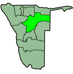 Grootfontein Grootfontein Constituency Grootfontein Constituency is an electoral constituency in the Otjozondjupa Region of Namibia. It has 21,595 inhabitants and consists of the town of Grootfontein and the surrounding rural area.... Okahandja Okahandja Constituency Okahandja Constituency is an electoral constituency in the Otjozondjupa Region of Namibia. It has 18,155 inhabitants and consists of the town of Okahandja and the surrounding rural area.... Okakarara Okakarara Constituency Okakarara Constituency is an electoral constituency in the Otjozondjupa Region of Namibia. It has 21,336 inhabitants and consists of the town of Okakarara and the surrounding rural area.... Omatako Omatako Constituency Omatako Constituency is an electoral constituency in the Otjozondjupa Region of Namibia. It has 11,998 inhabitants and contains the settlements of Kalkfeld, Hochfeld and Ovitoto, as well as the Osire refugee camp and Osona military base.... Otavi Otavi Constituency Otavi Constituency is an electoral constituency in the Otjozondjupa Region of Namibia. It has 11,620 inhabitants and consists of the town of Otavi and the surrounding rural area.... Otjiwarongo Otjiwarongo Constituency Otjiwarongo Constituency is an electoral constituency in the Otjozondjupa Region of Namibia. It has 22,614 inhabitants and consists of the town of Otjiwarongo and the surrounding rural area... Tsumkwe Tsumkwe Constituency Tsumkwe Constituency is an electoral constituency in the Otjozondjupa Region of Namibia. It has 8,823 inhabitants and consists of the settlement of Tsumkwe and the surrounding rural area.-2004:... |