

Elbe Sandstone Mountains
Encyclopedia
The Elbe Sandstone Mountains, also called the Elbe sandstone highlands is a mountain range
straddling the border between the state of Saxony
in southeastern Germany
and the North Bohemia
n region of the Czech Republic
, with about three-quarters of the area lying on the German side. The mountains are also referred to as Saxon Switzerland
and Bohemian Switzerland in both German and Czech (Sächsische Schweiz and Böhmische Schweiz in German, Saské Švýcarsko and České Švýcarsko in Czech) or simply combined as Saxon-Bohemian Switzerland. In both countries, the mountain range has been declared a national park. The name derives from the sandstone
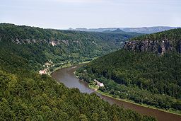
which was carved by erosion. The river Elbe
breaks through the mountain range in a steep and narrow valley.
in the northwest toward Bohemian Děčín
in the southeast. Their highest peak with 723 m (2,372 ft) is the Děčínský Sněžník
in Bohemian Switzerland on the left bank of the river in Bohemian Switzerland north of Děčín. The mountain range links the Ore Mountains in the west with the Lusatian Highlands range of the Sudetes in the east. Saxon Switzerland and the Zittau Mountains of the Lusatian Mountains
form the Saxon-Bohemian Chalk Sandstone Region
.
s, ravine
s, table mountain
s and rocky regions with undeveloped areas of forest. This diversity is ecologically significant. The variety of different locations, each with its own conditions in terms of soil
and microclimate
, has produced an enormous richness of species
. The numbers of fern
s and mosses alone is unmatched by any other of the German central uplands
.
The occurrence of Elbe sandstone
s and hence the Elbe Sandstone Mountains themselves is related to widespread deposition by a former sea in the Upper Cretaceous epoch. On the Saxon side of the border the term "Elbe Valley Cretaceous" (Elbtalkreide) is used, referring to a region stretching from Meißen-Oberau in the northwest through Dresden
and Pirna
into Saxon Switzerland, and which is formed by sandstones, planers and other rocks as well as basal conglomerates (Grundschottern or Basalkonglomerate) of older origin. Several erosion relics from Reinhardtsgrimma
through Dippoldiswalde
and the Tharandt Forest
to Siebenlehn form isolated examples south of Dresden. They are mainly characterised by sandstones.
On the Bohemian side the sandstone beds continue and form part of the North Bohemian Cretaceous (Nordböhmische Kreide). The chalk sediments of the Zittau Basin are counted as part of the latter due to their regional-geological relationships. The sedimentary sequences of the Cretaceous sea continue across a wide area of the Czech Republic to Moravia. Together these beds form the Saxon-Bohemian Cretaceous Zone. In Czech geological circles, the Elbe Valley Cretaceous is described as the foothills of the Bohemian Cretaceous Basin (Böhmischen Kreidebecken).
 The eroded sandstone
landscape of this region was formed from depositions that accumulated on the bottom of the sea millions of years ago. Large rivers carried sand and other eroded debris into the Cretaceous
sea. Rough quartz sand, clay and fine marl sank and became lithified
layer by layer. A compact sandstone sequence developed, about 20 x 30 kilometres wide and up to 600 metres thick dating to the lower Cenomanian
to Santonian
stages. The tremendous variety of shapes in the sandstone landscape is a result of the subsequent chemical and physical erosion
and biological processes acting on the rocks formed from those sands laid down during the Cretaceous
Period.
The inlets of a Cretaceous
sea, together with marine currents, carried away sand over a very long period of time into a shallow zone of the sea and then the diagenetic
processes at differing pressure regimes resulted in the formation of sandstone beds. Its stratification is characterized by variations in the horizontal structure (deposits of clay minerals, grain sizes of quartz, differences in the grain-cement) as well as a typical but fairly small fossil presence
and variably porous
strata.
After the Cretaceous sea had retreated (marine regression
), the surface of the land was shaped by weathering influences and watercourses, of which the Elbe made the deepest incision. Later the Lusatia
n granodiorite
was uplifted over the 600 metre thick sandstone slab along the Lusatian Fault
and pushed it downwards until it fractured. This northern boundary of the sandstone deposit lies roughly along the line Pillnitz
–Hohnstein–Hinterhermsdorf–Krásná Lípa
(Schönlinde).
 In the Tertiary
period, the adjacent region of the Central Bohemian Uplands and the Lusatian Mountains
was shaped and affected by intense volcanism
; but individual intrusion
s of magma
also forced their way through the sandstone platform of the Elbe Sandstone Mountains. The most striking evidence of this phase in the earth's history are the conical basaltic hills of Růžovský vrch
(Rosenberg), Cottaer Spitzberg
and Raumberg, but also Großer
and Kleiner Winterberg
.
At its southwestern edge the sandstone plate was uplifted by over 200 metres at the Karsdorf Fault
, whereby the slab was tilted even more and increased the gradient of the Elbe River. The water masses cut valleys into the rock with their streambeds and contributed in places to the formation of the rock faces. Over time the gradients reduced, the streambed of the Elbe widened out and changed its course time and again, partly as a result of the climatic influences of the ice ages.
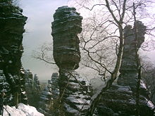
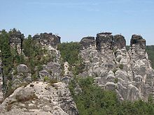
The mineral composition of the sandstone beds has a direct effect on the morphology of the terrain. The fine-grained form with clayey-silty cement between the quartz grains causes banks and slopes with terracing. The beds of sandstone with siliceous cement are typically the basis of the formation of rock faces and crags. Small variations in the cement composition of the rock can have a visible impact on the landscape.
Elbe Sandstone gets its characteristic cuboid appearance from
its thick horizontal strata (massive bedding) and its vertical fissure
s. In 1839 Bernhard Cotta
wrote about this in his comments on the geognostic map: "Vertical fissures and cracks cut through, often virtually at right angles, the horizontal layers and, as a result, parallelepiped
bodies are formed, that have given rise to the description Quader Sandstone.". Quader is German for an ashlar or block of stone, hence the name "Square Sandstone" is also used in English.
The term quader sandstone mountains or square sandstone mountains (Quadersandsteingebirge), introduced by Hanns Bruno Geinitz in 1849, is an historic, geological term for similar sandstone deposits, but was also used in connexion with the Elbe Sandstone Mountains..
The fissures were formed as a result of long-term tectonic stresses on the entire sandstone platform of the mountain range. This network of clefts runs through the sandstone beds in a relatively regular way, but in different directions in two regions of the range. Subsequent weathering processes of very different forms and simultaneous complex deposition (leaching, frost and salt wedging, wind
, solution weathering with sintering as well as biogenic and microbial
effects) have further changed the nature of the rock surface. For example, collapse caves, small hole-like cavities (honeycomb weathering
) with hourglass-shaped pillars (Sanduhr), chimneys, crevices and mighty, rugged rock faces.
Many morphological formations in the rocky landscape of the Elbe Sandstone Mountains are suspected to have been formed as a consequence of karstification. Important indicators of such processes in the polygenetic and polymorphic erosion landscape of the Elbe Sandstone Mountains are the furrows with parallel ridges between them (grykes and clints
) that look like cart ruts and which are particularly common, as well as extensive cave systems. They are occasionally described by the term pseudokarst. The application of the concept to several erosion formations in the sandstone of this mountain range is however contentious. Czech geologists have identified in quarzite-cemented sandstone areas in the northern part of the Bohemian Cretaceous Basin, karst
features in the shape of spherical caverns and cave formations. According to them, these emerged as a result of solution processes by water in complex interactions with iron compounds from neighbouring or intrusive
magmatic-volcanic rocks. The variation in relief in these sandstone regions is explained on the basis of these processes. The Elbe Sandstone Mountains are the greatest cretaceous sandstone erosion complex in Europe.
Human-induced changes caused by nearly 1,000 years of continual sandstone quarrying have also contributed in parts of the sandstone highlands to the appearance of the landscape today. The fissures (called Loose by the quarrymen) played an important role here, because they provided in effect natural divisions in the rock that were helpful when demolishing a rock face or when dressing the rough blocks of stone.
The sandstone of this region is a sought-after building material used for example, for imposing city edifices such as the Church of Our Lady in Dresden.
itself, founded in 1990 and covered an area of 93 km²; and the protected area
surrounding it that was founded in 1956 and covers 287 km². The German part of the range was also designated in May 2006 as one of the 77 most important national geotope
s in Germany by the Academy of Geosciences in Hanover.
In the Bohemian part of the range there has been a nature reserve in the northeastern region since 1972 called the Elbe Sandstone Protected Area (Chráněná krajinná oblast Labské pískovce) with an area of 324 km². In 2000, the Bohemian Switzerland National Park (Národní park České Švýcarsko) was established with an area of 79 km², bringing around 700 km² of the range under protection as a natural and cultural landscape.
 The Elbe Sandstone mountains have been a popular destination for tourists for more than 200 years, and for climbers for more than 100 years. It is also a popular recreation area for the nearby Saxon capital Dresden
. Places of interest include the Bastei
cliffs near Rathen, the Königstein Fortress
, Pravčická brána, the Schrammsteine
, Pfaffenstein
, and the valleys of the Kirnitzsch
and Kamenice rivers.
There are some 14,000 climbing routes via which mountain climbers can conquer 1100 free-standing peaks. Visitors can experience the natural scenes on the asphalt Elbe cycle path, or on board a steam paddleboat
that is part of the oldest fleet of its kind in the world.
The Elbe Sandstone Mountains have numerous facilities for cure and rehabilitation. The region has a tradition of many years. The discovery of ferrous and sulphurous sources in Bad Schandau
in 1730 led to its development as a health resort and the building of swimming baths.
Mountain range
A mountain range is a single, large mass consisting of a succession of mountains or narrowly spaced mountain ridges, with or without peaks, closely related in position, direction, formation, and age; a component part of a mountain system or of a mountain chain...
straddling the border between the state of Saxony
Saxony
The Free State of Saxony is a landlocked state of Germany, contingent with Brandenburg, Saxony Anhalt, Thuringia, Bavaria, the Czech Republic and Poland. It is the tenth-largest German state in area, with of Germany's sixteen states....
in southeastern Germany
Germany
Germany , officially the Federal Republic of Germany , is a federal parliamentary republic in Europe. The country consists of 16 states while the capital and largest city is Berlin. Germany covers an area of 357,021 km2 and has a largely temperate seasonal climate...
and the North Bohemia
Bohemia
Bohemia is a historical region in central Europe, occupying the western two-thirds of the traditional Czech Lands. It is located in the contemporary Czech Republic with its capital in Prague...
n region of the Czech Republic
Czech Republic
The Czech Republic is a landlocked country in Central Europe. The country is bordered by Poland to the northeast, Slovakia to the east, Austria to the south, and Germany to the west and northwest....
, with about three-quarters of the area lying on the German side. The mountains are also referred to as Saxon Switzerland
Saxon Switzerland
Saxon Switzerland is a hilly climbing area and national park around the Elbe valley south-east of Dresden in Saxony, Germany. Together with the Bohemian Switzerland in the Czech Republic it forms the Elbe Sandstone Mountains....
and Bohemian Switzerland in both German and Czech (Sächsische Schweiz and Böhmische Schweiz in German, Saské Švýcarsko and České Švýcarsko in Czech) or simply combined as Saxon-Bohemian Switzerland. In both countries, the mountain range has been declared a national park. The name derives from the sandstone
Sandstone
Sandstone is a sedimentary rock composed mainly of sand-sized minerals or rock grains.Most sandstone is composed of quartz and/or feldspar because these are the most common minerals in the Earth's crust. Like sand, sandstone may be any colour, but the most common colours are tan, brown, yellow,...
which was carved by erosion. The river Elbe
Elbe
The Elbe is one of the major rivers of Central Europe. It rises in the Krkonoše Mountains of the northwestern Czech Republic before traversing much of Bohemia , then Germany and flowing into the North Sea at Cuxhaven, 110 km northwest of Hamburg...
breaks through the mountain range in a steep and narrow valley.
Extent
The Elbe Sandstone Mountains extend on both sides of the Elbe from the Saxon town of PirnaPirna
Pirna is a town in the Free State of Saxony, Germany, capital of the administrative district Sächsische Schweiz-Osterzgebirge. The town's population is over 40,000. Pirna is located near Dresden and is an important district town as well as a Große Kreisstadt...
in the northwest toward Bohemian Děčín
Decín
Děčín is a town in the Ústí nad Labem Region in the north of the Czech Republic. It is the largest town and administrative seat of the Děčín District.-Geography:...
in the southeast. Their highest peak with 723 m (2,372 ft) is the Děčínský Sněžník
Decínský Snežník
The Děčínský Sněžník is a mountain in the Czech Republic and, at above sea level, the highest peak in the Elbe Sandstone Mountains. The Sněžník is located in the Jílové municipality, west of Děčín in the Ústí nad Labem Region, in the mountainous area of Bohemian Switzerland, close to the border...
in Bohemian Switzerland on the left bank of the river in Bohemian Switzerland north of Děčín. The mountain range links the Ore Mountains in the west with the Lusatian Highlands range of the Sudetes in the east. Saxon Switzerland and the Zittau Mountains of the Lusatian Mountains
Lusatian Mountains
The Lusatian Mountains are a mountain range of the Western Sudetes, located on the southeastern border of Germany with the Czech Republic east of the Elbe river, a continuation of the Ore Mountains range west of the Elbe valley...
form the Saxon-Bohemian Chalk Sandstone Region
Saxon-Bohemian Chalk Sandstone Region
The Saxon-Bohemian Chalk Sandstone Region is a natural region in south Saxony on the southern border with the Czech Republic. It forms part of the northern perimeter of the Bohemian Massif and comprises Saxon Switzerland, the German part of the Elbsandsteingebirge and the Zittau Hills, a small...
.
Terrain
The most striking characteristic of this deeply dissected rocky mountain range is the extraordinary variety of terrain within the smallest area. Unique amongst the Central European Uplands are the constant changes between plainPlain
In geography, a plain is land with relatively low relief, that is flat or gently rolling. Prairies and steppes are types of plains, and the archetype for a plain is often thought of as a grassland, but plains in their natural state may also be covered in shrublands, woodland and forest, or...
s, ravine
Ravine
A ravine is a landform narrower than a canyon and is often the product of streamcutting erosion. Ravines are typically classified as larger in scale than gullies, although smaller than valleys. A ravine is generally a fluvial slope landform of relatively steep sides, on the order of twenty to...
s, table mountain
Table (landform)
A table, when used in reference to landforms, is a hill, flank of a mountain, or mountain, that has a flat top.This landform has numerous names in addition to "table", including:*Tuya*Tepui*Mesa*Potrero*Butte*Plateau*Terrace-Description:...
s and rocky regions with undeveloped areas of forest. This diversity is ecologically significant. The variety of different locations, each with its own conditions in terms of soil
Soil
Soil is a natural body consisting of layers of mineral constituents of variable thicknesses, which differ from the parent materials in their morphological, physical, chemical, and mineralogical characteristics...
and microclimate
Microclimate
A microclimate is a local atmospheric zone where the climate differs from the surrounding area. The term may refer to areas as small as a few square feet or as large as many square miles...
, has produced an enormous richness of species
Species richness
Species richness is the number of different species in a given area. It is represented in equation form as S.Species richness is the fundamental unit in which to assess the homogeneity of an environment. Typically, species richness is used in conservation studies to determine the sensitivity of...
. The numbers of fern
Fern
A fern is any one of a group of about 12,000 species of plants belonging to the botanical group known as Pteridophyta. Unlike mosses, they have xylem and phloem . They have stems, leaves, and roots like other vascular plants...
s and mosses alone is unmatched by any other of the German central uplands
Central Uplands
The Central Uplands is one of the three major natural regions of Germany and covers most of the land area of the country. To the north lies the North German Plain or Northern Lowland; to the south, the Alps and the Alpine Foreland.- Formation :...
.
The occurrence of Elbe sandstone
Elbe Sandstone
Elbe Sandstone describes sandstones that naturally occur in North Bohemia and those parts of Saxony within the area around Dresden. It is named after the River Elbe, which cuts through the sandstone region in a transverse valley, the Elbe Valley Zone...
s and hence the Elbe Sandstone Mountains themselves is related to widespread deposition by a former sea in the Upper Cretaceous epoch. On the Saxon side of the border the term "Elbe Valley Cretaceous" (Elbtalkreide) is used, referring to a region stretching from Meißen-Oberau in the northwest through Dresden
Dresden
Dresden is the capital city of the Free State of Saxony in Germany. It is situated in a valley on the River Elbe, near the Czech border. The Dresden conurbation is part of the Saxon Triangle metropolitan area....
and Pirna
Pirna
Pirna is a town in the Free State of Saxony, Germany, capital of the administrative district Sächsische Schweiz-Osterzgebirge. The town's population is over 40,000. Pirna is located near Dresden and is an important district town as well as a Große Kreisstadt...
into Saxon Switzerland, and which is formed by sandstones, planers and other rocks as well as basal conglomerates (Grundschottern or Basalkonglomerate) of older origin. Several erosion relics from Reinhardtsgrimma
Reinhardtsgrimma
Reinhardtsgrimma is a former municipality in the district of Weißeritzkreis in Saxony in Germany located near Dresden. On 2 January 2008, it merged into the town Glashütte....
through Dippoldiswalde
Dippoldiswalde
Dippoldiswalde is a town in the Free State of Saxony, Germany, administrative center of the Sächsische Schweiz-Osterzgebirge district. It is situated 23 km east of Freiberg, and 18 km south of Dresden....
and the Tharandt Forest
Tharandt Forest
The Tharandt Forest is a landscape in the centre of the German Free State of Saxony and lies southwest of the forest town of Tharandt, south of the town of Wilsdruff, roughly between the cities of Freiberg and Dresden...
to Siebenlehn form isolated examples south of Dresden. They are mainly characterised by sandstones.
On the Bohemian side the sandstone beds continue and form part of the North Bohemian Cretaceous (Nordböhmische Kreide). The chalk sediments of the Zittau Basin are counted as part of the latter due to their regional-geological relationships. The sedimentary sequences of the Cretaceous sea continue across a wide area of the Czech Republic to Moravia. Together these beds form the Saxon-Bohemian Cretaceous Zone. In Czech geological circles, the Elbe Valley Cretaceous is described as the foothills of the Bohemian Cretaceous Basin (Böhmischen Kreidebecken).
Geology
Sandstone
Sandstone is a sedimentary rock composed mainly of sand-sized minerals or rock grains.Most sandstone is composed of quartz and/or feldspar because these are the most common minerals in the Earth's crust. Like sand, sandstone may be any colour, but the most common colours are tan, brown, yellow,...
landscape of this region was formed from depositions that accumulated on the bottom of the sea millions of years ago. Large rivers carried sand and other eroded debris into the Cretaceous
Cretaceous
The Cretaceous , derived from the Latin "creta" , usually abbreviated K for its German translation Kreide , is a geologic period and system from circa to million years ago. In the geologic timescale, the Cretaceous follows the Jurassic period and is followed by the Paleogene period of the...
sea. Rough quartz sand, clay and fine marl sank and became lithified
Diagenesis
In geology and oceanography, diagenesis is any chemical, physical, or biological change undergone by a sediment after its initial deposition and during and after its lithification, exclusive of surface alteration and metamorphism. These changes happen at relatively low temperatures and pressures...
layer by layer. A compact sandstone sequence developed, about 20 x 30 kilometres wide and up to 600 metres thick dating to the lower Cenomanian
Cenomanian
The Cenomanian is, in the ICS' geological timescale the oldest or earliest age of the Late Cretaceous epoch or the lowest stage of the Upper Cretaceous series. An age is a unit of geochronology: it is a unit of time; the stage is a unit in the stratigraphic column deposited during the corresponding...
to Santonian
Santonian
The Santonian is an age in the geologic timescale or a chronostratigraphic stage. It is a subdivision of the Late Cretaceous epoch or Upper Cretaceous series. It spans the time between 85.8 ± 0.7 mya and 83.5 ± 0.7 mya...
stages. The tremendous variety of shapes in the sandstone landscape is a result of the subsequent chemical and physical erosion
Erosion
Erosion is when materials are removed from the surface and changed into something else. It only works by hydraulic actions and transport of solids in the natural environment, and leads to the deposition of these materials elsewhere...
and biological processes acting on the rocks formed from those sands laid down during the Cretaceous
Cretaceous
The Cretaceous , derived from the Latin "creta" , usually abbreviated K for its German translation Kreide , is a geologic period and system from circa to million years ago. In the geologic timescale, the Cretaceous follows the Jurassic period and is followed by the Paleogene period of the...
Period.
The inlets of a Cretaceous
Cretaceous
The Cretaceous , derived from the Latin "creta" , usually abbreviated K for its German translation Kreide , is a geologic period and system from circa to million years ago. In the geologic timescale, the Cretaceous follows the Jurassic period and is followed by the Paleogene period of the...
sea, together with marine currents, carried away sand over a very long period of time into a shallow zone of the sea and then the diagenetic
Diagenesis
In geology and oceanography, diagenesis is any chemical, physical, or biological change undergone by a sediment after its initial deposition and during and after its lithification, exclusive of surface alteration and metamorphism. These changes happen at relatively low temperatures and pressures...
processes at differing pressure regimes resulted in the formation of sandstone beds. Its stratification is characterized by variations in the horizontal structure (deposits of clay minerals, grain sizes of quartz, differences in the grain-cement) as well as a typical but fairly small fossil presence
Fossil
Fossils are the preserved remains or traces of animals , plants, and other organisms from the remote past...
and variably porous
Porosity
Porosity or void fraction is a measure of the void spaces in a material, and is a fraction of the volume of voids over the total volume, between 0–1, or as a percentage between 0–100%...
strata.
After the Cretaceous sea had retreated (marine regression
Marine regression
Marine regression is a geological process occurring when areas of submerged seafloor are exposed above the sea level. The opposite event, marine transgression, occurs when flooding from the sea covers previously exposed land....
), the surface of the land was shaped by weathering influences and watercourses, of which the Elbe made the deepest incision. Later the Lusatia
Lusatia
Lusatia is a historical region in Central Europe. It stretches from the Bóbr and Kwisa rivers in the east to the Elbe valley in the west, today located within the German states of Saxony and Brandenburg as well as in the Lower Silesian and Lubusz voivodeships of western Poland...
n granodiorite
Granodiorite
Granodiorite is an intrusive igneous rock similar to granite, but containing more plagioclase than orthoclase-type feldspar. Officially, it is defined as a phaneritic igneous rock with greater than 20% quartz by volume where at least 65% of the feldspar is plagioclase. It usually contains abundant...
was uplifted over the 600 metre thick sandstone slab along the Lusatian Fault
Lusatian Fault
The Lusatian Fault , formerly Lusatian Overthrust , is the most important geological disturbance zone between the Elbe valley and the Giant Mountains. It is a fault that separates the granite of Lusatia from the Cretaceous sandstones of North Bohemia to the south...
and pushed it downwards until it fractured. This northern boundary of the sandstone deposit lies roughly along the line Pillnitz
Pillnitz
Pillnitz is a city quarter in the east of Dresden, Germany. The quarter is situated in the east of Dresden. It can be reached by bus, ship, walking along the river or by bicycle...
–Hohnstein–Hinterhermsdorf–Krásná Lípa
Krásná Lípa
Krásná Lípa is a town in the Ústí nad Labem Region of the Czech Republic. It has c. 3,500 inhabitants.- History :In 1361, a settlement was recorded on the Tollenstein . Later, about 30 families from Upper Franconia colonized the place. In 1654 the community had 36 farm houses and 60 craftsman...
(Schönlinde).
Tertiary
The Tertiary is a deprecated term for a geologic period 65 million to 2.6 million years ago. The Tertiary covered the time span between the superseded Secondary period and the Quaternary...
period, the adjacent region of the Central Bohemian Uplands and the Lusatian Mountains
Lusatian Mountains
The Lusatian Mountains are a mountain range of the Western Sudetes, located on the southeastern border of Germany with the Czech Republic east of the Elbe river, a continuation of the Ore Mountains range west of the Elbe valley...
was shaped and affected by intense volcanism
Volcanism
Volcanism is the phenomenon connected with volcanoes and volcanic activity. It includes all phenomena resulting from and causing magma within the crust or mantle of a planet to rise through the crust and form volcanic rocks on the surface....
; but individual intrusion
Intrusion
An intrusion is liquid rock that forms under Earth's surface. Magma from under the surface is slowly pushed up from deep within the earth into any cracks or spaces it can find, sometimes pushing existing country rock out of the way, a process that can take millions of years. As the rock slowly...
s of magma
Magma
Magma is a mixture of molten rock, volatiles and solids that is found beneath the surface of the Earth, and is expected to exist on other terrestrial planets. Besides molten rock, magma may also contain suspended crystals and dissolved gas and sometimes also gas bubbles. Magma often collects in...
also forced their way through the sandstone platform of the Elbe Sandstone Mountains. The most striking evidence of this phase in the earth's history are the conical basaltic hills of Růžovský vrch
Růžovský vrch
The Růžovský vrch, also Růžák is the dominant mountain in the Bohemian Switzerland east of the River Elbe in the Czech Republic. Its almost circular cone shape makes it one of the most typical representatives of the mountains of North Bohemia. The upper part of the mountain is made of basalt,...
(Rosenberg), Cottaer Spitzberg
Cottaer Spitzberg
The Cottaer Spitzberg is a 390.8 m high basalt dome on the western edge of Saxon Switzerland. Since 1979 the hill has been a protected area due to its geological and botanical features.- Location and area :...
and Raumberg, but also Großer
Großer Winterberg
Großer Winterberg is a mountain of Saxony, southeastern Germany....
and Kleiner Winterberg
Kleiner Winterberg (Saxon Switzerland)
Kleiner Winterberg is a mountain of Saxon Switzerland.....
.
At its southwestern edge the sandstone plate was uplifted by over 200 metres at the Karsdorf Fault
Karsdorf Fault
The Karsdorf Fault is a striking tectonic fracture line, which is part of the Central Saxon Fault, and is located in the eastern Ore Mountains and the Elbe Valley Slate Mountains...
, whereby the slab was tilted even more and increased the gradient of the Elbe River. The water masses cut valleys into the rock with their streambeds and contributed in places to the formation of the rock faces. Over time the gradients reduced, the streambed of the Elbe widened out and changed its course time and again, partly as a result of the climatic influences of the ice ages.
The mineral composition of the sandstone beds has a direct effect on the morphology of the terrain. The fine-grained form with clayey-silty cement between the quartz grains causes banks and slopes with terracing. The beds of sandstone with siliceous cement are typically the basis of the formation of rock faces and crags. Small variations in the cement composition of the rock can have a visible impact on the landscape.
Elbe Sandstone gets its characteristic cuboid appearance from
its thick horizontal strata (massive bedding) and its vertical fissure
Fissure
In anatomy, a fissure is a groove, natural division, deep furrow, elongated cleft, or tear in various parts of the body.-Brain:...
s. In 1839 Bernhard Cotta
Bernhard von Cotta
Carl Bernhard von Cotta, known as Bernhard von Cotta , was a German geologist.He was born in a forester's lodge at Kleine Zillbach, Meiningen, near Eisenach, the son of Heinrich von Cotta, founder of the Tharandt Forestry Academy near Dresden...
wrote about this in his comments on the geognostic map: "Vertical fissures and cracks cut through, often virtually at right angles, the horizontal layers and, as a result, parallelepiped
Parallelepiped
In geometry, a parallelepiped is a three-dimensional figure formed by six parallelograms. By analogy, it relates to a parallelogram just as a cube relates to a square. In Euclidean geometry, its definition encompasses all four concepts...
bodies are formed, that have given rise to the description Quader Sandstone.". Quader is German for an ashlar or block of stone, hence the name "Square Sandstone" is also used in English.
The term quader sandstone mountains or square sandstone mountains (Quadersandsteingebirge), introduced by Hanns Bruno Geinitz in 1849, is an historic, geological term for similar sandstone deposits, but was also used in connexion with the Elbe Sandstone Mountains..
The fissures were formed as a result of long-term tectonic stresses on the entire sandstone platform of the mountain range. This network of clefts runs through the sandstone beds in a relatively regular way, but in different directions in two regions of the range. Subsequent weathering processes of very different forms and simultaneous complex deposition (leaching, frost and salt wedging, wind
Corrasion
Corrasion is a geographical term for the process of mechanical erosion of a rock surface caused when materials are transported across it by running water, glaciers, wind, waves or gravitational movement downslope, for example, the wearing away of fine particles of rock on a river or seabed by a...
, solution weathering with sintering as well as biogenic and microbial
Microorganism
A microorganism or microbe is a microscopic organism that comprises either a single cell , cell clusters, or no cell at all...
effects) have further changed the nature of the rock surface. For example, collapse caves, small hole-like cavities (honeycomb weathering
Honeycomb weathering
Honeycomb weathering, also known as fretting, cavernous weathering, alveoli/alveolar weathering, stone lattice, stone lace or miniature tafoni weathering is a type of salt weathering common on coastal and semi-arid granites, sandstones and limestones...
) with hourglass-shaped pillars (Sanduhr), chimneys, crevices and mighty, rugged rock faces.
Many morphological formations in the rocky landscape of the Elbe Sandstone Mountains are suspected to have been formed as a consequence of karstification. Important indicators of such processes in the polygenetic and polymorphic erosion landscape of the Elbe Sandstone Mountains are the furrows with parallel ridges between them (grykes and clints
Limestone pavement
A limestone pavement is a natural karst landform consisting of a flat, incised surface of exposed limestone that resembles an artificial pavement. The term is mainly used in the UK where many of these landforms have developed distinctive surface patterning resembling block of paving...
) that look like cart ruts and which are particularly common, as well as extensive cave systems. They are occasionally described by the term pseudokarst. The application of the concept to several erosion formations in the sandstone of this mountain range is however contentious. Czech geologists have identified in quarzite-cemented sandstone areas in the northern part of the Bohemian Cretaceous Basin, karst
KARST
Kilometer-square Area Radio Synthesis Telescope is a Chinese telescope project to which FAST is a forerunner. KARST is a set of large spherical reflectors on karst landforms, which are bowlshaped limestone sinkholes named after the Kras region in Slovenia and Northern Italy. It will consist of...
features in the shape of spherical caverns and cave formations. According to them, these emerged as a result of solution processes by water in complex interactions with iron compounds from neighbouring or intrusive
Intrusion
An intrusion is liquid rock that forms under Earth's surface. Magma from under the surface is slowly pushed up from deep within the earth into any cracks or spaces it can find, sometimes pushing existing country rock out of the way, a process that can take millions of years. As the rock slowly...
magmatic-volcanic rocks. The variation in relief in these sandstone regions is explained on the basis of these processes. The Elbe Sandstone Mountains are the greatest cretaceous sandstone erosion complex in Europe.
Human-induced changes caused by nearly 1,000 years of continual sandstone quarrying have also contributed in parts of the sandstone highlands to the appearance of the landscape today. The fissures (called Loose by the quarrymen) played an important role here, because they provided in effect natural divisions in the rock that were helpful when demolishing a rock face or when dressing the rough blocks of stone.
The sandstone of this region is a sought-after building material used for example, for imposing city edifices such as the Church of Our Lady in Dresden.
Conservation
Large parts of the Elbe Sandstone Mountains are under statutory protection. In Germany there is the national park region of Saxon Switzerland, which consists two elements: the Saxon Switzerland National ParkSaxon Switzerland National Park
The Saxon Switzerland National Park , is a National Park in the German Free State of Saxony near the capital city of Dresden. It covers two areas of 93.5 km² in the heart of the German part of the Elbe Sandstone Mountains which is called the Saxon Switzerland .The National Park is not far away...
itself, founded in 1990 and covered an area of 93 km²; and the protected area
Protected area
Protected areas are locations which receive protection because of their recognised natural, ecological and/or cultural values. There are several kinds of protected areas, which vary by level of protection depending on the enabling laws of each country or the regulations of the international...
surrounding it that was founded in 1956 and covers 287 km². The German part of the range was also designated in May 2006 as one of the 77 most important national geotope
Geotope
Geotope is the geological component of the abiotic matrix present in an ecotope. Example geotopes might be: an exposed outcrop of rocks, an erratic boulder, a grotto or ravine, a cave, an old stone wall marking a property boundary, and so forth....
s in Germany by the Academy of Geosciences in Hanover.
In the Bohemian part of the range there has been a nature reserve in the northeastern region since 1972 called the Elbe Sandstone Protected Area (Chráněná krajinná oblast Labské pískovce) with an area of 324 km². In 2000, the Bohemian Switzerland National Park (Národní park České Švýcarsko) was established with an area of 79 km², bringing around 700 km² of the range under protection as a natural and cultural landscape.
Tourism
Dresden
Dresden is the capital city of the Free State of Saxony in Germany. It is situated in a valley on the River Elbe, near the Czech border. The Dresden conurbation is part of the Saxon Triangle metropolitan area....
. Places of interest include the Bastei
Bastei
The Bastei is a spectacular rock formation towering 194 metres above the Elbe River in the Elbe Sandstone Mountains of Germany. Reaching a height of 305 metres above sea level, the jagged rocks of the Bastei were formed by water erosion over one million years ago...
cliffs near Rathen, the Königstein Fortress
Königstein Fortress
Königstein Fortress , the "Saxon Bastille", is a hilltop fortress near Dresden, in Saxon Switzerland, Germany, above the town of Königstein on the left bank of the River Elbe...
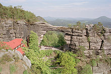
, Pravčická brána, the Schrammsteine
Schrammsteine
The Schrammsteine are a long, strung-out, very jagged group of rocks in the Elbe Sandstone Mountains located east of Bad Schandau in Saxon Switzerland in East Germany. To the north they are bordered by the Kirnitzsch valley, to the south by the Elbe valley and to the east by the Affensteine rocks....
, Pfaffenstein
Pfaffenstein
The Pfaffenstein, formerly called the Jungfernstein, is a low table mountain, , in the Elbe Sandstone Mountains in Saxony. It lies west of the River Elbe near Königstein and is also referred to as "Saxon Switzerland in miniature" on account of its diverse structure.The wild, jagged mountain with...
, and the valleys of the Kirnitzsch
Kirnitzsch
The Kirnitzsch, in Bohemia also called the Kirnischt , is a right tributary of the River Elbe, which passes through the Czech Republic and the German Free State of Saxony.- Geography :...
and Kamenice rivers.
There are some 14,000 climbing routes via which mountain climbers can conquer 1100 free-standing peaks. Visitors can experience the natural scenes on the asphalt Elbe cycle path, or on board a steam paddleboat
Paddle steamer
A paddle steamer is a steamship or riverboat, powered by a steam engine, using paddle wheels to propel it through the water. In antiquity, Paddle wheelers followed the development of poles, oars and sails, where the first uses were wheelers driven by animals or humans...
that is part of the oldest fleet of its kind in the world.
The Elbe Sandstone Mountains have numerous facilities for cure and rehabilitation. The region has a tradition of many years. The discovery of ferrous and sulphurous sources in Bad Schandau
Bad Schandau
Bad Schandau is a spa town in Germany, in the south of the Free State of Saxony and the district of Sächsische Schweiz-Osterzgebirge. It is situated on the right bank of the Elbe, at the mouth of the little valley of the Kirnitzsch.-Geography:...
in 1730 led to its development as a health resort and the building of swimming baths.