

Drummore
Encyclopedia
Not to be confused with Drummuir
, north east Scotland
Drummore (from the Gaelic: see below) is a village at the southern end of the Rhins of Galloway
in Scotland
: it has two satellite clachans, called Kirkmaiden and Damnaglaur. The village lies where the Kildonan Burn runs out to the sea, a few miles north of the Mull of Galloway
. It is the most southerly in Scotland
, and further south than the English cities of Durham
and Carlisle
. It is in the Dumfries and Galloway
Council area and the parish and community of Kirkmaiden
and is about 16 miles (25.7 km) from the nearest major town, the ferry port of Stranraer
. In 1998 the population was 310.
Drummore shares its name with High Drummore a mile up Glen Lee, and also with Drummore Glen half a mile to the east. The underlying name is clearly the Gaelic
"druim mor" or "big ridge", and it has been suggested that this reflected the motte associated with the castle of the Adairs
of Kinhilt, whose lands were granted in 1602 by King James VI
. The rather scattered incidence of related names, however, probably makes it more likely that the hill-ridge itself is in question, for all that at 200 rising to 300 feet (91.4 m) it is not all that prominent compared to the 450 feet (137.2 m) Muntloch Fell and Inshanks Fell a mile or two to the west, or even the 250 feet (76.2 m) Mull of Galloway
itself three miles (5 km) to the south.
A branch line was proposed in 1877 linking to the Portpatrick Railway. It was opposed by the feudal landowner, the Earl of Stair, and finally abandoned after the failure of the City of Glasgow Bank
in 1882; aspects of the village's street layout still reflect plans for the railway.
was an area of early Christian activity following the missionary work of Ninian
across Luce Bay
in the Machars
. Shortly before 1860, at Low Curghie less than a mile up the coast north of Drummore, and not far from an extant standing stone, a gravestone was discovered which appeared to date to the 5th or 6th century, with a weathered Latin
inscription in which the name “Ventidius” was legible along with another word which translated as “sub-deacon”. Many place-names testify to Norse
influence in the southern Rhins, as in many of the west-coast islands and peninsula
s, but Drummore's Gaelic name is in tune with the general use of Gaelic in Galloway
after the Dark Ages until it was supplanted by English
under Presbyterian
influence in the 17th century.
, named after St Maiden or Medan
. The parish church
was originally some five miles (8 km) south of the village, but in 1638 the parishioners, citing the inconvenience of the journey to church, secured the building of a new church known as Kirk Covenant on Core Hill, about a mile west of Drummore. Following the Disruption of 1843
, a new church was again built, for worshippers in the Free Church of Scotland
, and this time in the village itself, in the street now known as Stair Street. Early in the 20th century the two congregations were reunited. Now worship is habitually at the church within Drummore, with one service each month in the summer being held at Kirk Covenant.
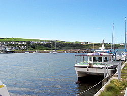 The harbour, facing north and shielded by the Rhins from the prevailing south-westerly wind, was developed with a jetty in the early 19th century to serve a lime manufacturing industry. For many years in the hands of the UK
's Ministry of Defence
as part of the management of their bombing range and weapon development area
offshore in Luce Bay
, it was taken over in 2004 for a nominal sum by the Drummore Harbour Trust Ltd, which announced the aim of developing its use for pleasure boats.
This disposal by the MoD
attracted attention in the UK Parliament as a result of disputes over the rights of access to the harbour by fishermen, and a subsequent Court of Session
judgement confirmed a Victorian
precedent that no right of harbour existed. Failure of the Drummore Harbour Trust to widen its membership beyond the initial two individual members, or to begin its promised investment programme, caused increasing concern. However, in July 2008 the Dumfries and Galloway Council decided to seek an Empowerment Order under the Harbours Act 1964 which would enable the Council to take over the harbour land and operations, following the pattern of a number of successful harbours along the Solway
coast.
The village’s facilities still however include the Mariners Coffee Shop, the Queen's Hotel, a post office
, a volunteer tourist office and a general shop on Mill Street; a garage for repairs and fuel (diesel only); a primary school; a doctor's surgery and pharmacy; the Ship Inn on the shore (refurbished 2007 and now a Thai restaurant); a bowling club and children’s play park; a number of holiday cottages; and two caravan sites near sandy beaches (one of them associated with another pub). The Kirkmaiden
Community Council meets monthly in Drummore. Housing is mixed, ranging from listed Victorian residential and commercial properties to modern bungalows and harl
ed council houses.
Within living memory a number of street names have changed, notably Stair
Street (formerly Church Street), Mill Street (formerly Main Street) and Harbour Road (formerly Quay Road). Following a landslip in the 1960s the former Lower Road, which had brought traffic in along the coast to Shore Street, was barred to traffic; it is now a footpath, set thickly about by Japanese knotweed
.
Drummuir
Drummuir is a small village in Scotland, in the traditional county of Banffshire, and in the Moray council area. It is between Dufftown , Keith and Huntly ....
, north east Scotland
Drummore (from the Gaelic: see below) is a village at the southern end of the Rhins of Galloway
Rhins of Galloway
The Rhins of Galloway is a hammer-head peninsula in Dumfries and Galloway, Scotland...
in Scotland
Scotland
Scotland is a country that is part of the United Kingdom. Occupying the northern third of the island of Great Britain, it shares a border with England to the south and is bounded by the North Sea to the east, the Atlantic Ocean to the north and west, and the North Channel and Irish Sea to the...
: it has two satellite clachans, called Kirkmaiden and Damnaglaur. The village lies where the Kildonan Burn runs out to the sea, a few miles north of the Mull of Galloway
Mull of Galloway
The Mull of Galloway is the southernmost point of Scotland. It is situated in Wigtownshire, Dumfries and Galloway.A lighthouse is positioned at the point . Built in 1830 by engineer Robert Stevenson, the white-painted round tower is high...
. It is the most southerly in Scotland
Scotland
Scotland is a country that is part of the United Kingdom. Occupying the northern third of the island of Great Britain, it shares a border with England to the south and is bounded by the North Sea to the east, the Atlantic Ocean to the north and west, and the North Channel and Irish Sea to the...
, and further south than the English cities of Durham
Durham
Durham is a city in north east England. It is within the County Durham local government district, and is the county town of the larger ceremonial county...
and Carlisle
City of Carlisle
The City of Carlisle is a local government district of Cumbria, England, with the status of a city and non-metropolitan district. It is named after its largest settlement, Carlisle, but covers a far larger area which includes the towns of Brampton and Longtown, as well as outlying villages...
. It is in the Dumfries and Galloway
Dumfries and Galloway
Dumfries and Galloway is one of 32 unitary council areas of Scotland. It was one of the nine administrative 'regions' of mainland Scotland created in 1975 by the Local Government etc. Act 1973...
Council area and the parish and community of Kirkmaiden
Kirkmaiden
Kirkmaiden is a civil parish in the Rinns of Galloway, the most southerly in Scotland; the present Church of Scotland parish has the same name as and is approximately coterminous with the original pre-Reformation parish....
and is about 16 miles (25.7 km) from the nearest major town, the ferry port of Stranraer
Stranraer
Stranraer is a town in the southwest of Scotland. It lies in the west of Dumfries and Galloway and in the county of Wigtownshire.Stranraer lies on the shores of Loch Ryan on the northern side of the isthmus joining the Rhins of Galloway to the mainland...
. In 1998 the population was 310.
Drummore shares its name with High Drummore a mile up Glen Lee, and also with Drummore Glen half a mile to the east. The underlying name is clearly the Gaelic
Scottish Gaelic language
Scottish Gaelic is a Celtic language native to Scotland. A member of the Goidelic branch of the Celtic languages, Scottish Gaelic, like Modern Irish and Manx, developed out of Middle Irish, and thus descends ultimately from Primitive Irish....
"druim mor" or "big ridge", and it has been suggested that this reflected the motte associated with the castle of the Adairs
Ballymena
Ballymena is a large town in County Antrim, Northern Ireland and the seat of Ballymena Borough Council. Ballymena had a population of 28,717 people in the 2001 Census....
of Kinhilt, whose lands were granted in 1602 by King James VI
James I of England
James VI and I was King of Scots as James VI from 24 July 1567 and King of England and Ireland as James I from the union of the English and Scottish crowns on 24 March 1603...
. The rather scattered incidence of related names, however, probably makes it more likely that the hill-ridge itself is in question, for all that at 200 rising to 300 feet (91.4 m) it is not all that prominent compared to the 450 feet (137.2 m) Muntloch Fell and Inshanks Fell a mile or two to the west, or even the 250 feet (76.2 m) Mull of Galloway
Mull of Galloway
The Mull of Galloway is the southernmost point of Scotland. It is situated in Wigtownshire, Dumfries and Galloway.A lighthouse is positioned at the point . Built in 1830 by engineer Robert Stevenson, the white-painted round tower is high...
itself three miles (5 km) to the south.
A branch line was proposed in 1877 linking to the Portpatrick Railway. It was opposed by the feudal landowner, the Earl of Stair, and finally abandoned after the failure of the City of Glasgow Bank
City of Glasgow Bank
The City of Glasgow Bank is now largely known for its spectacular collapse in October 1878, ruining all but 254 of its 1,200 shareholders, whose liability was not limited. It was the last case of a British Bank run until that of Northern Rock in 2007.-General:...
in 1882; aspects of the village's street layout still reflect plans for the railway.
Early history and language
The southern RhinsRhins of Galloway
The Rhins of Galloway is a hammer-head peninsula in Dumfries and Galloway, Scotland...
was an area of early Christian activity following the missionary work of Ninian
Saint Ninian
Saint Ninian is a Christian saint first mentioned in the 8th century as being an early missionary among the Pictish peoples of what is now Scotland...
across Luce Bay
Luce Bay
Luce Bay is a large bay in Wigtownshire in southern Scotland. The bay is 20 miles wide at its mouth and is bounded by the Rhins of Galloway to the west and the Machars to the east....
in the Machars
Machars
The Machars is a peninsula in Galloway in the south-west of Scotland. The word is derived from the Gaelic word Machair meaning low lying or level land, known as "links" on the east coast of Scotland...
. Shortly before 1860, at Low Curghie less than a mile up the coast north of Drummore, and not far from an extant standing stone, a gravestone was discovered which appeared to date to the 5th or 6th century, with a weathered Latin
Latin
Latin is an Italic language originally spoken in Latium and Ancient Rome. It, along with most European languages, is a descendant of the ancient Proto-Indo-European language. Although it is considered a dead language, a number of scholars and members of the Christian clergy speak it fluently, and...
inscription in which the name “Ventidius” was legible along with another word which translated as “sub-deacon”. Many place-names testify to Norse
Norsemen
Norsemen is used to refer to the group of people as a whole who spoke what is now called the Old Norse language belonging to the North Germanic branch of Indo-European languages, especially Norwegian, Icelandic, Faroese, Swedish and Danish in their earlier forms.The meaning of Norseman was "people...
influence in the southern Rhins, as in many of the west-coast islands and peninsula
Peninsula
A peninsula is a piece of land that is bordered by water on three sides but connected to mainland. In many Germanic and Celtic languages and also in Baltic, Slavic and Hungarian, peninsulas are called "half-islands"....
s, but Drummore's Gaelic name is in tune with the general use of Gaelic in Galloway
Galloway
Galloway is an area in southwestern Scotland. It usually refers to the former counties of Wigtownshire and Kirkcudbrightshire...
after the Dark Ages until it was supplanted by English
English language
English is a West Germanic language that arose in the Anglo-Saxon kingdoms of England and spread into what was to become south-east Scotland under the influence of the Anglian medieval kingdom of Northumbria...
under Presbyterian
Church of Scotland
The Church of Scotland, known informally by its Scots language name, the Kirk, is a Presbyterian church, decisively shaped by the Scottish Reformation....
influence in the 17th century.
Ecclesiastical history
Drummore is the largest settlement in the parish of KirkmaidenKirkmaiden
Kirkmaiden is a civil parish in the Rinns of Galloway, the most southerly in Scotland; the present Church of Scotland parish has the same name as and is approximately coterminous with the original pre-Reformation parish....
, named after St Maiden or Medan
Saint Medan
Saint Medan was a saint, apparently of the early British or Irish period, whose existence and name are inferred from the name Kirkmaiden in Wigtownshire, but who is also associated with Angus and Aberdeenshire.-The occurrence and legend of Medan:...
. The parish church
Parish church
A parish church , in Christianity, is the church which acts as the religious centre of a parish, the basic administrative unit of episcopal churches....
was originally some five miles (8 km) south of the village, but in 1638 the parishioners, citing the inconvenience of the journey to church, secured the building of a new church known as Kirk Covenant on Core Hill, about a mile west of Drummore. Following the Disruption of 1843
Disruption of 1843
The Disruption of 1843 was a schism within the established Church of Scotland, in which 450 ministers of the Church broke away, over the issue of the Church's relationship with the State, to form the Free Church of Scotland...
, a new church was again built, for worshippers in the Free Church of Scotland
Free Church of Scotland (1843-1900)
The Free Church of Scotland is a Scottish denomination which was formed in 1843 by a large withdrawal from the established Church of Scotland in a schism known as the "Disruption of 1843"...
, and this time in the village itself, in the street now known as Stair Street. Early in the 20th century the two congregations were reunited. Now worship is habitually at the church within Drummore, with one service each month in the summer being held at Kirk Covenant.
Drummore Harbour
United Kingdom
The United Kingdom of Great Britain and Northern IrelandIn the United Kingdom and Dependencies, other languages have been officially recognised as legitimate autochthonous languages under the European Charter for Regional or Minority Languages...
's Ministry of Defence
Ministry of Defence (United Kingdom)
The Ministry of Defence is the United Kingdom government department responsible for implementation of government defence policy and is the headquarters of the British Armed Forces....
as part of the management of their bombing range and weapon development area
RAF West Freugh
RAF West Freugh is a Royal Air Force station located in Wigtownshire, five miles south east of Stranraer, Dumfries and Galloway, Scotland....
offshore in Luce Bay
Luce Bay
Luce Bay is a large bay in Wigtownshire in southern Scotland. The bay is 20 miles wide at its mouth and is bounded by the Rhins of Galloway to the west and the Machars to the east....
, it was taken over in 2004 for a nominal sum by the Drummore Harbour Trust Ltd, which announced the aim of developing its use for pleasure boats.
This disposal by the MoD
Ministry of Defence (United Kingdom)
The Ministry of Defence is the United Kingdom government department responsible for implementation of government defence policy and is the headquarters of the British Armed Forces....
attracted attention in the UK Parliament as a result of disputes over the rights of access to the harbour by fishermen, and a subsequent Court of Session
Court of Session
The Court of Session is the supreme civil court of Scotland, and constitutes part of the College of Justice. It sits in Parliament House in Edinburgh and is both a court of first instance and a court of appeal....
judgement confirmed a Victorian
Victorian era
The Victorian era of British history was the period of Queen Victoria's reign from 20 June 1837 until her death on 22 January 1901. It was a long period of peace, prosperity, refined sensibilities and national self-confidence...
precedent that no right of harbour existed. Failure of the Drummore Harbour Trust to widen its membership beyond the initial two individual members, or to begin its promised investment programme, caused increasing concern. However, in July 2008 the Dumfries and Galloway Council decided to seek an Empowerment Order under the Harbours Act 1964 which would enable the Council to take over the harbour land and operations, following the pattern of a number of successful harbours along the Solway
Solway
-Places:New Zealand*Solway, New Zealand, a suburb of MastertonUnited Kingdom*Solway Firth, the inlet between the north west of England and southern Scotland*Solway Moss, lowland peat bog in Cumbria, England, near the Scottish border...
coast.
Character and facilities
Older residents recall a time when the main streets were full of shops, including no fewer than three bakers (one on the corner of Stair and Mill Streets). Even recently there have been significant casualties, including on Mill Street the bank, the butcher's (now wholesale only, as a result of over-demanding EU health legislation), and the Harbour Stores (formerly the second general shop, with an additional specialty in fishing supplies).The village’s facilities still however include the Mariners Coffee Shop, the Queen's Hotel, a post office
Post office
A post office is a facility forming part of a postal system for the posting, receipt, sorting, handling, transmission or delivery of mail.Post offices offer mail-related services such as post office boxes, postage and packaging supplies...
, a volunteer tourist office and a general shop on Mill Street; a garage for repairs and fuel (diesel only); a primary school; a doctor's surgery and pharmacy; the Ship Inn on the shore (refurbished 2007 and now a Thai restaurant); a bowling club and children’s play park; a number of holiday cottages; and two caravan sites near sandy beaches (one of them associated with another pub). The Kirkmaiden
Kirkmaiden
Kirkmaiden is a civil parish in the Rinns of Galloway, the most southerly in Scotland; the present Church of Scotland parish has the same name as and is approximately coterminous with the original pre-Reformation parish....
Community Council meets monthly in Drummore. Housing is mixed, ranging from listed Victorian residential and commercial properties to modern bungalows and harl
Harl
Harling is a Scottish term describing an exterior building surfacing technique. The theory of harling is to produce a long-lasting weatherproof shield for a stone building. A pigment can be embedded in the harled material, thus obviating the need for repainting...
ed council houses.
Within living memory a number of street names have changed, notably Stair
Earl of Stair
Earl of Stair is a title in the Peerage of Scotland. It was created in 1703 for the lawyer and statesman John Dalrymple, 2nd Viscount of Stair. He actively supported William III's claim to the throne and served as Secretary of State for Scotland. However, he was forced to resign after he authorised...
Street (formerly Church Street), Mill Street (formerly Main Street) and Harbour Road (formerly Quay Road). Following a landslip in the 1960s the former Lower Road, which had brought traffic in along the coast to Shore Street, was barred to traffic; it is now a footpath, set thickly about by Japanese knotweed
Japanese knotweed
Japanese Knotweed is a large, herbaceous perennial plant, native to eastern Asia in Japan, China and Korea...
.