

Machars
Encyclopedia
Peninsula
A peninsula is a piece of land that is bordered by water on three sides but connected to mainland. In many Germanic and Celtic languages and also in Baltic, Slavic and Hungarian, peninsulas are called "half-islands"....
in Galloway
Galloway
Galloway is an area in southwestern Scotland. It usually refers to the former counties of Wigtownshire and Kirkcudbrightshire...
in the south-west of Scotland
Scotland
Scotland is a country that is part of the United Kingdom. Occupying the northern third of the island of Great Britain, it shares a border with England to the south and is bounded by the North Sea to the east, the Atlantic Ocean to the north and west, and the North Channel and Irish Sea to the...
. The word is derived from the Gaelic
Goidelic languages
The Goidelic languages or Gaelic languages are one of the two branches of the Insular Celtic languages, the other consisting of the Brythonic languages. Goidelic languages historically formed a dialect continuum stretching from the south of Ireland through the Isle of Man to the north of Scotland...
word Machair
Machair (geography)
The machair refers to a fertile low-lying grassy plain found on some of the north-west coastlines of Ireland and Scotland, in particular the Outer Hebrides...
meaning low lying or level land, known as "links" on the east coast of Scotland. Although there are no high peaks in the Machars, it is not flat and would best be described as undulating or rolling. The North Atlantic Drift
North Atlantic Drift
North Atlantic Drift is:* An ocean current that continues from the North Atlantic Current* An album by Ocean Colour Scene: North Atlantic Drift this doesn't make any goddamn sense....
or Gulf Stream
Gulf Stream
The Gulf Stream, together with its northern extension towards Europe, the North Atlantic Drift, is a powerful, warm, and swift Atlantic ocean current that originates at the tip of Florida, and follows the eastern coastlines of the United States and Newfoundland before crossing the Atlantic Ocean...
creates a mild climate in which plants normally associated with the Southern Hemisphere
Southern Hemisphere
The Southern Hemisphere is the part of Earth that lies south of the equator. The word hemisphere literally means 'half ball' or "half sphere"...
can thrive, and dolphin
Dolphin
Dolphins are marine mammals that are closely related to whales and porpoises. There are almost forty species of dolphin in 17 genera. They vary in size from and , up to and . They are found worldwide, mostly in the shallower seas of the continental shelves, and are carnivores, mostly eating...
s and basking shark
Basking shark
The basking shark is the second largest living fish, after the whale shark. It is a cosmopolitan migratory species, found in all the world's temperate oceans. It is a slow moving and generally harmless filter feeder and has anatomical adaptations to filter feeding, such as a greatly enlarged...
s are frequently seen in the seas.
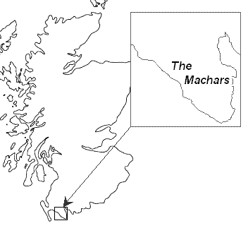
The Machars peninsula is roughly defined by a northern boundary stretching from Newton Stewart
Newton Stewart
Newton Stewart is a burgh town in the south of Scotland in the west of the region of Dumfries and Galloway and in the county of Wigtownshire....
to Glenluce
Glenluce
Glenluce is a village in the Scottish area of Dumfries and Galloway.Located on the A75 road between Stranraer and Newton Stewart it is in the traditional county of Wigtownshire. Glenluce Abbey is nearby at ....
, the only other boundary being the sea. The forty-mile coastline has enormous variety, starting with the mud-flats of Wigtown
Wigtown
Wigtown is a town and former royal burgh in the Machars of Galloway in the south west of Scotland. It lies south of Newton Stewart and east of Stranraer. It has a population of about 1,000...
on the east facing Wigtown Bay, down to the sandy beach at Rigg Bay in Garlieston
Garlieston
Garlieston is a small planned coastal village in south west Scotland founded circa 1790 by Lord Garlies.-Location & History:The village lies northwest of Whithorn and a few miles north of Cruggleton Castle which was abandoned in the 17th century...
(where the Mulberry Harbour
Mulberry harbour
A Mulberry harbour was a British type of temporary harbour developed in World War II to offload cargo on the beaches during the Allied invasion of Normandy....
s were developed). The coastline then rises to form dramatic cliffs as it passes the ruins of Cruggleton Castle
Cruggleton Castle
Cruggleton Castle is a ruined castle on the eastern coast of the Machars peninusula, Dumfries and Galloway, Scotland.It is located on a high outcrop of shale, part of the cliff edge, about 4 km south east of the village of Garlieston...
, dropping a little at Portyerrock Bay and the Isle of Whithorn
Isle of Whithorn
Isle of Whithorn is one of the most southerly villages and seaports in Scotland, lying on the coast, north east of Burrow Head, about three miles from Whithorn. Whithorn, , is a former royal burgh in Dumfries and Galloway, with which the Isle of Whithorn is frequently incorrectly amalgamated or...
, and rising again at Burrow Head
Burrow Head
Burrow Head is the southernmost tip of the Machars peninsula in south-west Scotland.It is located approximately two miles south-west of Isle of Whithorn, Wigtownshire and is the second southernmost point of Scotland ....
(where much of the cult classic The Wicker Man was filmed).
Past the southern tip of the peninsula, the shoreline leaves Wigtown Bay and becomes part of Luce Bay
Luce Bay
Luce Bay is a large bay in Wigtownshire in southern Scotland. The bay is 20 miles wide at its mouth and is bounded by the Rhins of Galloway to the west and the Machars to the east....
. The cliffs continue as far as the beautiful sandy beach at Monreith
Monreith
Monreith is a small seaside town located in the Machars, Dumfries and Galloway, Scotland....
(home of the author Gavin Maxwell
Gavin Maxwell
Gavin Maxwell FRSL, FIAL, FZS , FRGS was a Scottish naturalist and author, best known for his work with otters. He wrote the book Ring of Bright Water about how he brought an otter back from Iraq and raised it in Scotland...
), and on past Port William
Port William
Port William is a small fishing village in the county of Wigtownshire in south west Scotland. At present it comes under the administrative authority of Dumfries and Galloway...
. A combination of rocky shoreline, sandy beaches and cliffs continues as far as Auchenmalg
Auchenmalg
Auchenmalg is a small hamlet situated on Luce Bay in Wigtownshire, Scotland. Auchenmalg consists of a village hall, a public house called the Cock Inn, and a caravan park called [Luce Bay Holiday Park]. The Cock Inn is the second-oldest pub in Scotland....
and Stairhaven before the sandy dunes approaching Glenluce
Glenluce
Glenluce is a village in the Scottish area of Dumfries and Galloway.Located on the A75 road between Stranraer and Newton Stewart it is in the traditional county of Wigtownshire. Glenluce Abbey is nearby at ....
. Two rivers cut through the peninsula, the River Bladnoch
River Bladnoch
The Bladnoch is a river in the Machars of Galloway in southwest Scotland. One of the earliest descriptions of it is given by Sir Andrew Agnew of Lochnaw and Sir David Dunbar in an appendix to Andrew Symson's work A Large Description of Galloway written in the 17th century...
which rises at Loch Maberry and meets the sea just south of Wigtown
Wigtown
Wigtown is a town and former royal burgh in the Machars of Galloway in the south west of Scotland. It lies south of Newton Stewart and east of Stranraer. It has a population of about 1,000...
, and one of its major tributaries the Tarf Water
Tarf Water, Wigtownshire
The Tarf Water is a river in the former county of Wigtownshire in south-west Scotland. It rises on the Ayrshire border and flows in a generally southeastward direction to meet the River Bladnoch near the village of Kirkcowan It has no major tributaries but is fed by numerous burns which drain an...
which meets the Bladnoch near Kirkcowan
Kirkcowan
Kirkcowan is a village and parish in Dumfries and Galloway, Scotland.It is situated in the north of the Machars peninsula, about 7 miles south south west of Newton Stewart....
. Another tributary of the Bladnoch is the large stream the Water of Malzie which rises in the large expanses of peat bog near the Old Place of Mochrum before meeting the Bladnoch near Corzmalie.
Generally speaking the Eastern half of the Machars can be described as being a landscape of rolling green hills and scattered woodland which forms a perfect setting for the large scale dairy industry which can be found here. In fact up until recent decades a large scale creamery was to be found at Sorbie
Sorbie
Sorbie is a small village in Dumfries and Galloway, Scotland.It is located mid-way between Wigtown and Whithorn on the A714 road. Formerly served by the Wigtownshire Railway branch of the Portpatrick and Wigtownshire Joint Railway, Sorbie once boasted a creamery some of whose produce was exported...
although this has now closed. This landscape extends to the far southern extremities of the peninsula, however the landscape to the North West is significantly different, where above the raised beaches of Luce Bay a rugged expanse of moorland and bog can be found, more reminiscent of the rough country to the north. The highest point of the Machars can be found here, Mochrum Fell, however for the most part the terrain can be characterised as a series of low, stony ridges interspersed by large expanses of peat bog and moorland and many small lochs. This part of the Machars is generally associated with large scale forestry plantations, especially of Sitka Spruce
Sitka Spruce
Picea sitchensis, the Sitka Spruce, is a large coniferous evergreen tree growing to 50–70 m tall, exceptionally to 95 m tall, and with a trunk diameter of up to 5 m, exceptionally to 6–7 m diameter...
, and stock-rearing, either the hardy Belted Galloway
Belted Galloway
The Belted Galloway is a rare beef breed of cattle originating from Galloway in South West Scotland, adapted to living on the poor upland pastures and windswept moorlands of the region...
or more typically Galloway
Galloway
Galloway is an area in southwestern Scotland. It usually refers to the former counties of Wigtownshire and Kirkcudbrightshire...
cattle or sheep.
Geography
The other principal settlements on the penisula are:Kirkcowan
Kirkcowan
Kirkcowan is a village and parish in Dumfries and Galloway, Scotland.It is situated in the north of the Machars peninsula, about 7 miles south south west of Newton Stewart....
, Whithorn
Whithorn
Whithorn is a former royal burgh in Dumfries and Galloway, Scotland, about ten miles south of Wigtown. The town was the location of the first recorded Christian church in Scotland, Candida Casa : the 'White [or 'Shining'] House', built by Saint Ninian about 397.-Eighth and twelfth centuries:A...
, Kirkinner
Kirkinner
Kirkinner is a small village located in the Machars, Dumfries and Galloway, Scotland....
, Sorbie
Sorbie
Sorbie is a small village in Dumfries and Galloway, Scotland.It is located mid-way between Wigtown and Whithorn on the A714 road. Formerly served by the Wigtownshire Railway branch of the Portpatrick and Wigtownshire Joint Railway, Sorbie once boasted a creamery some of whose produce was exported...
, Mochrum
Mochrum
Mochrum is a small agricultural parish in Wigtownshire on the west of the Machars peninsula, Dumfries and Galloway, Scotland. It has a population of about 125 which is considerably lower than the population of about 150 years ago. It lies 3.1 km north of the small fishing village of Port...
, Elrig
Elrig
Elrig is a Clachan in Dumfries and Galloway, Scotland. Located in the Machars peninsula, about 3 miles north of Port William.Elrig is the birthplace of author and naturalist Gavin Maxwell, who was born at the House of Elrig. His boyhood is recounted in The House of Elrig, published in 1965...
, Bladnoch and Whauphill
Whauphill
Whauphill is a small village located in the Machars, Dumfries and Galloway, Scotland....
.
There are a number of large lochs in the area including Mochrum Loch, Castle Loch and the White Loch of Myrton.
The area is rich in prehistoric remains, mainly in the form of standing stones and cup and ring marks. The most notable of these are Torhousekie and Drumtroddan. In Castle Loch near The Old Place of Mochrum are the remains of several crannog
Crannog
A crannog is typically a partially or entirely artificial island, usually built in lakes, rivers and estuarine waters of Scotland and Ireland. Crannogs were used as dwellings over five millennia from the European Neolithic Period, to as late as the 17th/early 18th century although in Scotland,...
s.
The primary industry in the area was agriculture, though today the tourist industry probably employs more people and generates more income.
Burrow Head (the southernmost tip of the peninsula) is about eighteen miles from Point of Ayre
Point of Ayre
The Point of Ayre is the northernmost point of the Isle of Man. It lies at the northern end of Ramsey Bay north of the town of Ramsey. The point can be accessed by the A16 road from Bride....
on the Isle of Man
Isle of Man
The Isle of Man , otherwise known simply as Mann , is a self-governing British Crown Dependency, located in the Irish Sea between the islands of Great Britain and Ireland, within the British Isles. The head of state is Queen Elizabeth II, who holds the title of Lord of Mann. The Lord of Mann is...
, and trade links have long existed between the two places, much of which involved smuggling.
RAF Wigtown
The Machers is also home to the former RAF Wigtown. The airfield, which was opened in 1941 and is often referred to as Baldoon, was used in World War Two as a training school - hosting the No 1 Air Observers School from September 13, 1941, to February 1, 1942, and operating in conjunction with a tracked target range near the coast to the southeast.Although the site originally consisted of grass runways, flooding of the land soon caused these to become unusable, and two concrete runways were installed during 1942.
Operations at the airfield ceased in 1945, to coincide with the end of the war, and control of the site was given over Maintenance Command who was placed in care and maintenance, transferring to No 14 Maintenance Unit from July 1, 1946, to March 1, 1948, when the airfield was finally closed.
Despite considerable deterioration the airfield remains intact; with the original control tower still standing and nearly all the perimeter and access roads remaining. Furthermore, the concrete bases of many of the hangars and other buildings can still be seen on the ground.
Today much of the land has reverted to agricultural use, with the site becoming popular for locals to conduct leisure activities – such as walking or cycling.
Saint Ninian
Saint NinianSaint Ninian
Saint Ninian is a Christian saint first mentioned in the 8th century as being an early missionary among the Pictish peoples of what is now Scotland...
first brought Christianity
Christianity
Christianity is a monotheistic religion based on the life and teachings of Jesus as presented in canonical gospels and other New Testament writings...
to what-would-become Scotland via the Machars, founding a small church at the Isle of Whithorn
Isle of Whithorn
Isle of Whithorn is one of the most southerly villages and seaports in Scotland, lying on the coast, north east of Burrow Head, about three miles from Whithorn. Whithorn, , is a former royal burgh in Dumfries and Galloway, with which the Isle of Whithorn is frequently incorrectly amalgamated or...
from which a mediæval cathedral later sprang at Whithorn
Whithorn
Whithorn is a former royal burgh in Dumfries and Galloway, Scotland, about ten miles south of Wigtown. The town was the location of the first recorded Christian church in Scotland, Candida Casa : the 'White [or 'Shining'] House', built by Saint Ninian about 397.-Eighth and twelfth centuries:A...
. Ninian studied under St Martin of Tours
Martin of Tours
Martin of Tours was a Bishop of Tours whose shrine became a famous stopping-point for pilgrims on the road to Santiago de Compostela. Around his name much legendary material accrued, and he has become one of the most familiar and recognizable Christian saints...
and can lay claim to bringing Christianity to Scotland long before St Columba
Columba
Saint Columba —also known as Colum Cille , Colm Cille , Calum Cille and Kolban or Kolbjørn —was a Gaelic Irish missionary monk who propagated Christianity among the Picts during the Early Medieval Period...
, whose church at Iona
Iona
Iona is a small island in the Inner Hebrides off the western coast of Scotland. It was a centre of Irish monasticism for four centuries and is today renowned for its tranquility and natural beauty. It is a popular tourist destination and a place for retreats...
is often mistakenly credited as the cradle of Scottish Christianity.