

Rhins of Galloway
Encyclopedia
The Rhins of Galloway is a hammer-head peninsula
in Dumfries and Galloway
, Scotland
. Stretching more than 25 miles (40.2 km) from north to south, its southern tip is the Mull of Galloway
, the southernmost point of Scotland.
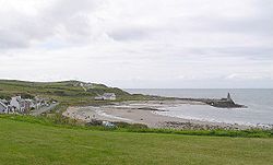
The principal settlements are Stranraer
at the head of Loch Ryan and the small tourist village of Portpatrick
on the west coast, other villages are dotted up and down the peninsula, including Kirkcolm, Leswalt
, Lochans, and in the South Rhins; Stoneykirk
, Sandhead
, Ardwell
and Drummore
.
Herbert Maxwell defines "Rhinns" as rionn, rinn, meaning a point or promontory.
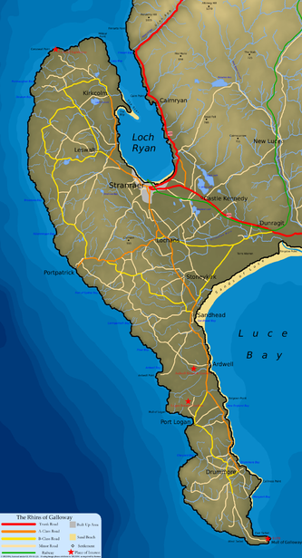 The peninsula is bounded on its west coast by the North Channel
and by Loch Ryan
and Luce Bay
in the east. With around 50 miles (80.5 km) of coastline running from Stranraer
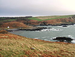
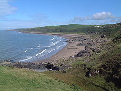
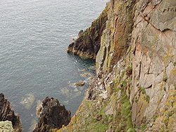
in the north to Torrs Warren in the south the land is heavily influenced by the seas. The coastal landscape varies; with the western coast generally having steep rugged cliffs and occasional inlets, which contrasts with the calmer eastern coast, with its sandy beaches and softer landscape.
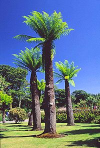
Sitting on the west coast of Scotland receiving the westerlies from the Atlantic the area receives a large amount of rainfall (around 1000 mm annually); this has led to the peninsula being principally used for farming, with the relatively flat land offering good dairy
and beef production. Due to the seas very much 'surrounding' the land the area sees a significant effect of the North Atlantic drift
, which ensures that the land is cooled in the summer and warmed in the winter, producing a stabilising effect on the temperatures. Severe frosts are therefore minimised and this allows the area to play host to numerous tropical palms and flora which otherwise could not exist this far north. Examples of these tropical plants can be seen at Logan Botanical Gardens
.
 The natural geography of the Rhins has led directly to the use of the area for development, with the entire peninsula acting as a huge breakwater from the currents of the North Channel and to a lesser extent the Atlantic. This creates relatively calm and safe waters in Loch Ryan and Luce Bay which can be utilised. This is most easily shown with the ferries that sail to Belfast
and Larne
, which were originally based at Portpatrick. As the ships became larger they required larger protective harbours and the exposed Portpatrick could no longer fulfil the needs and so they moved to the shelter of Loch Ryan from where they still sail today.
The southernmost point of the Rhinns is also the southernmost point in Scotland, The Mull of Galloway
. Here the land and rocky cliffs support a diverse range of animals and plants, with the mull area designated a site of special scientific interest and it has become a RSPB nature reserve
. Razorbills, Guillemots and Puffins are just three of the bird species which nest on the steep cliffs.
Just north of the Mull the land narrows significantly, forming two bays (the East and West Tarbets), here in ancient times boats were brought ashore and moved across the thin strip of land by man power, with the aid of log rollers and lubrication. This large effort to cross the land bridge was all in an attempt to avoid navigation around the Mull and its dangerous currents.
The Southern Upland Way
begins in the Rhins at Portpatrick and winds its way through the area on its long journey east across Scotland to its finish at Cockburnspath
in the east.
 Having been settled from ancient times, the area has a long history, forming part of the western kingdoms that collectively ruled most of western Scotland, Ireland, the Isle of Man and Wales. The Novantae
Celt
ic tribe was based in the Rhinns area and were known to the Romans
as trading partners.
Subsistence, Crofting
, lifestyles are likely to have been dominant throughout much of the peninsula's history. Farming would have been practised to satisfy the needs of the tenants and, later on, the estates. Fishing would have generally been practised on a local scale for local consumption rather than export. Due to the very sparse populations that lived in the area it was not until the Industrial Revolution
that changes from a basic subsistence crofting lifestyle would be noted.
Resources in the area were traditionally used locally and increasingly exported. Salt Pans on the western coast of the peninsula were used for centuries as a local source of salt. Kelp harvesting became increasingly popular, both for local uses and also exported for use in chemical production. Sands, silts and gravels, common to all glaciated alluvial areas were frequently quarried.
 As communications improved the wealth of the area improved, with the sea links to Ireland
, Glasgow
& Liverpool
both allowing the export of local farming produce (thus encouraging farming for production rather than subsistence) and also import of materials and goods not common to the area. The importance of the area's proximity to Ireland
led to significant infrastructure being developed, most notably the link to the railway network, which was laid to Portpatrick to ensure a fast passage for the mail boat to Donaghadee
. As the ships which served the North Channel route increased in size it became more difficult for Portpatrick to offer a safe harbour, with the shipping routes eventually moving in 1849 to the calmer waters of Stranraer in Loch Ryan.
During the Second World War
the area became an important station for anti-U-Boat
activities, with flying boats operating from the Loch side of the peninsula at RAF Station Wig Bay, as well as RAF Station Stranraer. RAF Corsewall operated north of Kirkcolm and was mainly used as a training school for flying boats. The bombing range in Luce Bay
was used extensively throughout the second world war, with facilities based at West Freugh and Drummore
 In modern times the peninsula consists of a patchwork of farms running the full length of the land. Increasingly the area is diversifying into tourism as small scale farming becomes less economically viable. The natural beauty of the area, with its long rugged coastline and numerous small bays is ideal for attracting tourists. The relatively sparse population is also a key asset, in a time when many tourist locations are suffering over popularity. The natural beauty of the area saw the BBC
deciding to film the drama Two Thousand Acres of Sky
in the village of Port Logan
.
Sites of interest in and around the Rhinns include:
Peninsula
A peninsula is a piece of land that is bordered by water on three sides but connected to mainland. In many Germanic and Celtic languages and also in Baltic, Slavic and Hungarian, peninsulas are called "half-islands"....
in Dumfries and Galloway
Dumfries and Galloway
Dumfries and Galloway is one of 32 unitary council areas of Scotland. It was one of the nine administrative 'regions' of mainland Scotland created in 1975 by the Local Government etc. Act 1973...
, Scotland
Scotland
Scotland is a country that is part of the United Kingdom. Occupying the northern third of the island of Great Britain, it shares a border with England to the south and is bounded by the North Sea to the east, the Atlantic Ocean to the north and west, and the North Channel and Irish Sea to the...
. Stretching more than 25 miles (40.2 km) from north to south, its southern tip is the Mull of Galloway
Mull of Galloway
The Mull of Galloway is the southernmost point of Scotland. It is situated in Wigtownshire, Dumfries and Galloway.A lighthouse is positioned at the point . Built in 1830 by engineer Robert Stevenson, the white-painted round tower is high...
, the southernmost point of Scotland.
The principal settlements are Stranraer
Stranraer
Stranraer is a town in the southwest of Scotland. It lies in the west of Dumfries and Galloway and in the county of Wigtownshire.Stranraer lies on the shores of Loch Ryan on the northern side of the isthmus joining the Rhins of Galloway to the mainland...
at the head of Loch Ryan and the small tourist village of Portpatrick
Portpatrick
Portpatrick is a village hanging on to the extreme south-westerly tip of mainland Scotland, cut into a cleft in steep cliffs.Dating back historically some 500 years, and built adjacent to the ruins of nearby Dunskey Castle, its position on the Rhins of Galloway affords visitors views of the...
on the west coast, other villages are dotted up and down the peninsula, including Kirkcolm, Leswalt
Leswalt
Leswalt is a name of unknown origins. Possible derivations for its name include llys gwellt meaning grass court or perhaps lios uillt meaning fort of the glen - referring to Lochnaw Castle.- Leswalt Parish :...
, Lochans, and in the South Rhins; Stoneykirk
Stoneykirk
Stoneykirk is a small village and civil parish in Dumfries and Galloway, south west Scotland. It sits in the heart of the Rhins of Galloway, south of Stranraer. The the A716 runs through part of the village. The village developed around the village's church , with a number of small cottages...
, Sandhead
Sandhead
Sandhead is a small village in Dumfries and Galloway, south west Scotland. It overlooks Luce Bay, 7 miles south of Stranraer. The old main road, named "Main Street", runs through the village, but the A716 now bypasses it with a narrow and twisting carriageway...
, Ardwell
Ardwell
Ardwell is a village in the Scottish unitary council area of Dumfries and Galloway. It lies on the shores of Luce Bay in the southern part of the Rhins of Galloway. The A716 road to Drummore or the Mull of Galloway passes through the village...
and Drummore
Drummore
Not to be confused with Drummuir, north east ScotlandDrummore is a village at the southern end of the Rhins of Galloway in Scotland: it has two satellite clachans, called Kirkmaiden and Damnaglaur. The village lies where the Kildonan Burn runs out to the sea, a few miles north of the Mull of...
.
Herbert Maxwell defines "Rhinns" as rionn, rinn, meaning a point or promontory.
Geography and climate
North Channel (British Isles)
The North Channel is the strait which separates eastern Northern Ireland from southwestern Scotland...
and by Loch Ryan
Loch Ryan
Loch Ryan is a Scottish sea loch that acts as an important natural harbour for shipping, providing calm waters for ferries operating between Scotland and Northern Ireland...
and Luce Bay
Luce Bay
Luce Bay is a large bay in Wigtownshire in southern Scotland. The bay is 20 miles wide at its mouth and is bounded by the Rhins of Galloway to the west and the Machars to the east....
in the east. With around 50 miles (80.5 km) of coastline running from Stranraer
Stranraer
Stranraer is a town in the southwest of Scotland. It lies in the west of Dumfries and Galloway and in the county of Wigtownshire.Stranraer lies on the shores of Loch Ryan on the northern side of the isthmus joining the Rhins of Galloway to the mainland...
in the north to Torrs Warren in the south the land is heavily influenced by the seas. The coastal landscape varies; with the western coast generally having steep rugged cliffs and occasional inlets, which contrasts with the calmer eastern coast, with its sandy beaches and softer landscape.
Sitting on the west coast of Scotland receiving the westerlies from the Atlantic the area receives a large amount of rainfall (around 1000 mm annually); this has led to the peninsula being principally used for farming, with the relatively flat land offering good dairy
Dairy farming
Dairy farming is a class of agricultural, or an animal husbandry, enterprise, for long-term production of milk, usually from dairy cows but also from goats and sheep, which may be either processed on-site or transported to a dairy factory for processing and eventual retail sale.Most dairy farms...
and beef production. Due to the seas very much 'surrounding' the land the area sees a significant effect of the North Atlantic drift
North Atlantic Drift
North Atlantic Drift is:* An ocean current that continues from the North Atlantic Current* An album by Ocean Colour Scene: North Atlantic Drift this doesn't make any goddamn sense....
, which ensures that the land is cooled in the summer and warmed in the winter, producing a stabilising effect on the temperatures. Severe frosts are therefore minimised and this allows the area to play host to numerous tropical palms and flora which otherwise could not exist this far north. Examples of these tropical plants can be seen at Logan Botanical Gardens
Logan Botanic Garden
Logan Botanic Garden is a botanical garden located near Port Logan on the Rhins of Galloway, the south-western tip of Scotland.The area has a mild climate, due to the influence of the North Atlantic drift. This enables plants which would not normally survive outdoors in Scotland to flourish. There...
.
Belfast
Belfast is the capital of and largest city in Northern Ireland. By population, it is the 14th biggest city in the United Kingdom and second biggest on the island of Ireland . It is the seat of the devolved government and legislative Northern Ireland Assembly...
and Larne
Larne
Larne is a substantial seaport and industrial market town on the east coast of County Antrim, Northern Ireland with a population of 18,228 people in the 2001 Census. As of 2011, there are about 31,000 residents in the greater Larne area. It has been used as a seaport for over 1,000 years, and is...
, which were originally based at Portpatrick. As the ships became larger they required larger protective harbours and the exposed Portpatrick could no longer fulfil the needs and so they moved to the shelter of Loch Ryan from where they still sail today.
The southernmost point of the Rhinns is also the southernmost point in Scotland, The Mull of Galloway
Mull of Galloway
The Mull of Galloway is the southernmost point of Scotland. It is situated in Wigtownshire, Dumfries and Galloway.A lighthouse is positioned at the point . Built in 1830 by engineer Robert Stevenson, the white-painted round tower is high...
. Here the land and rocky cliffs support a diverse range of animals and plants, with the mull area designated a site of special scientific interest and it has become a RSPB nature reserve
Nature reserve
A nature reserve is a protected area of importance for wildlife, flora, fauna or features of geological or other special interest, which is reserved and managed for conservation and to provide special opportunities for study or research...
. Razorbills, Guillemots and Puffins are just three of the bird species which nest on the steep cliffs.
Just north of the Mull the land narrows significantly, forming two bays (the East and West Tarbets), here in ancient times boats were brought ashore and moved across the thin strip of land by man power, with the aid of log rollers and lubrication. This large effort to cross the land bridge was all in an attempt to avoid navigation around the Mull and its dangerous currents.
The Southern Upland Way
Southern Upland Way
Opened in 1984, the Southern Upland Way is a coast to coast walk in Scotland between Portpatrick in the west and Cockburnspath in the east....
begins in the Rhins at Portpatrick and winds its way through the area on its long journey east across Scotland to its finish at Cockburnspath
Cockburnspath
Cockburnspath is a village in the Scottish Borders area of Scotland. It lies near the North Sea coast between Berwick-upon-Tweed and Edinburgh. It is at the eastern extremity of the Southern Upland Way, a long-distance footpath from the west to east coast of Scotland, and it is also the terminus...
in the east.
 |
 |
History and settlements
Novantae
The Novantae were a people of the late 2nd century who lived in what is now Galloway and Carrick, in southwestern-most Scotland. They are mentioned briefly in Ptolemy's Geography The Novantae were a people of the late 2nd century who lived in what is now Galloway and Carrick, in southwestern-most...
Celt
Celt
The Celts were a diverse group of tribal societies in Iron Age and Roman-era Europe who spoke Celtic languages.The earliest archaeological culture commonly accepted as Celtic, or rather Proto-Celtic, was the central European Hallstatt culture , named for the rich grave finds in Hallstatt, Austria....
ic tribe was based in the Rhinns area and were known to the Romans
Ancient Rome
Ancient Rome was a thriving civilization that grew on the Italian Peninsula as early as the 8th century BC. Located along the Mediterranean Sea and centered on the city of Rome, it expanded to one of the largest empires in the ancient world....
as trading partners.
Subsistence, Crofting
Crofting
Crofting is a form of land tenure and small-scale food production unique to the Scottish Highlands, the Islands of Scotland, and formerly on the Isle of Man....
, lifestyles are likely to have been dominant throughout much of the peninsula's history. Farming would have been practised to satisfy the needs of the tenants and, later on, the estates. Fishing would have generally been practised on a local scale for local consumption rather than export. Due to the very sparse populations that lived in the area it was not until the Industrial Revolution
Industrial Revolution
The Industrial Revolution was a period from the 18th to the 19th century where major changes in agriculture, manufacturing, mining, transportation, and technology had a profound effect on the social, economic and cultural conditions of the times...
that changes from a basic subsistence crofting lifestyle would be noted.
Resources in the area were traditionally used locally and increasingly exported. Salt Pans on the western coast of the peninsula were used for centuries as a local source of salt. Kelp harvesting became increasingly popular, both for local uses and also exported for use in chemical production. Sands, silts and gravels, common to all glaciated alluvial areas were frequently quarried.
Ireland
Ireland is an island to the northwest of continental Europe. It is the third-largest island in Europe and the twentieth-largest island on Earth...
, Glasgow
Glasgow
Glasgow is the largest city in Scotland and third most populous in the United Kingdom. The city is situated on the River Clyde in the country's west central lowlands...
& Liverpool
Liverpool
Liverpool is a city and metropolitan borough of Merseyside, England, along the eastern side of the Mersey Estuary. It was founded as a borough in 1207 and was granted city status in 1880...
both allowing the export of local farming produce (thus encouraging farming for production rather than subsistence) and also import of materials and goods not common to the area. The importance of the area's proximity to Ireland
Ireland
Ireland is an island to the northwest of continental Europe. It is the third-largest island in Europe and the twentieth-largest island on Earth...
led to significant infrastructure being developed, most notably the link to the railway network, which was laid to Portpatrick to ensure a fast passage for the mail boat to Donaghadee
Donaghadee
Donaghadee is a small town in County Down, Northern Ireland. It lies on the northeast coast of the Ards Peninsula, about east of Belfast and about six miles south east of Bangor. It had a population of 6,470 people in the 2001 Census...
. As the ships which served the North Channel route increased in size it became more difficult for Portpatrick to offer a safe harbour, with the shipping routes eventually moving in 1849 to the calmer waters of Stranraer in Loch Ryan.
During the Second World War
World War II
World War II, or the Second World War , was a global conflict lasting from 1939 to 1945, involving most of the world's nations—including all of the great powers—eventually forming two opposing military alliances: the Allies and the Axis...
the area became an important station for anti-U-Boat
U-boat
U-boat is the anglicized version of the German word U-Boot , itself an abbreviation of Unterseeboot , and refers to military submarines operated by Germany, particularly in World War I and World War II...
activities, with flying boats operating from the Loch side of the peninsula at RAF Station Wig Bay, as well as RAF Station Stranraer. RAF Corsewall operated north of Kirkcolm and was mainly used as a training school for flying boats. The bombing range in Luce Bay
Luce Bay
Luce Bay is a large bay in Wigtownshire in southern Scotland. The bay is 20 miles wide at its mouth and is bounded by the Rhins of Galloway to the west and the Machars to the east....
was used extensively throughout the second world war, with facilities based at West Freugh and Drummore
BBC
The British Broadcasting Corporation is a British public service broadcaster. Its headquarters is at Broadcasting House in the City of Westminster, London. It is the largest broadcaster in the world, with about 23,000 staff...
deciding to film the drama Two Thousand Acres of Sky
Two Thousand Acres of Sky
Two Thousand Acres of Sky was a TV drama which aired on BBC Television from 2001 to 2003. It is also syndicated in the United States on PBS. It was created and written by Timothy Prager. The Executive Producer was Adrian Bate....
in the village of Port Logan
Port Logan
Port Logan, formerly Port Nessock, is a small village in the parish of Kirkmaiden in the Rhins of Galloway in Wigtownshire.Port Nessock Bay is now all that remains of the western end of a strait that in post-glacial times separated the main part of what is now the Rinns of Galloway from three...
.
Sites of interest in and around the Rhinns include:
- Corsewall LighthouseCorsewall LighthouseCorsewall Lighthouse is a lighthouse at Corsewall Point, Kirkcolm near Stranraer in the region of Dumfries and Galloway in Scotland. First lit in 1817, it overlooks the North Channel of the Irish Sea. The definition of the name Corsewall is the place or well of the Cross.-History:In 1814, a Kirkman...
, sitting at the northern end of the peninsula, it is now a four star hotel - Lochnaw CastleLochnaw CastleLochnaw Castle is a 16th Century tower house five miles from the town of Stranraer, Dumfries and Galloway.Lochnaw Castle shows four periods of construction - a simple 16th century keep, 17th and 18th century domestic dwellings, and a mansion-house, which was later demolished. There is a plaque...
near LeswaltLeswaltLeswalt is a name of unknown origins. Possible derivations for its name include llys gwellt meaning grass court or perhaps lios uillt meaning fort of the glen - referring to Lochnaw Castle.- Leswalt Parish :...
which is the ancestral seat of Clan AgnewClan AgnewClan Agnew is a Lowland Scottish clan from Wigtownshire and Galloway in the southwest of Scotland.-Origins:There are two theories as to the origins of the name Agnew. The most widely accepted is that the name is French and derives from the Barony d'Agneaux in Normandy. Emigrants from the region... - West Freugh RAFRoyal Air ForceThe Royal Air Force is the aerial warfare service branch of the British Armed Forces. Formed on 1 April 1918, it is the oldest independent air force in the world...
station near StoneykirkStoneykirkStoneykirk is a small village and civil parish in Dumfries and Galloway, south west Scotland. It sits in the heart of the Rhins of Galloway, south of Stranraer. The the A716 runs through part of the village. The village developed around the village's church , with a number of small cottages...
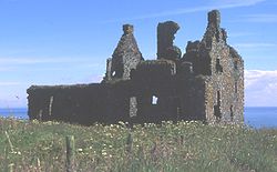
which was (and to a lesser extent still is) used by the RAF as an airfield for bombing target practice out in Luce Bay - Dunskey CastleDunskey CastleDunskey Castle is a ruined, early 16th century tower house, located south of the village of Portpatrick, Dumfries and Galloway, on the south-west coast of Scotland....
near Portpatrick, built in the 16th century by the Adairs of Kilhilt, with now only the remains remaining - Port LoganPort LoganPort Logan, formerly Port Nessock, is a small village in the parish of Kirkmaiden in the Rhins of Galloway in Wigtownshire.Port Nessock Bay is now all that remains of the western end of a strait that in post-glacial times separated the main part of what is now the Rinns of Galloway from three...
village, where the BBCBBCThe British Broadcasting Corporation is a British public service broadcaster. Its headquarters is at Broadcasting House in the City of Westminster, London. It is the largest broadcaster in the world, with about 23,000 staff...
drama Two Thousand Acres of SkyTwo Thousand Acres of SkyTwo Thousand Acres of Sky was a TV drama which aired on BBC Television from 2001 to 2003. It is also syndicated in the United States on PBS. It was created and written by Timothy Prager. The Executive Producer was Adrian Bate....
was filmed, and the nearby Logan outstation of the Royal Botanic Garden, Edinburgh. - Ardwell House & Gardens near ArdwellArdwellArdwell is a village in the Scottish unitary council area of Dumfries and Galloway. It lies on the shores of Luce Bay in the southern part of the Rhins of Galloway. The A716 road to Drummore or the Mull of Galloway passes through the village...
, the estate house and gardens of Ardwell estates - Kirkmadrine Stones near SandheadSandheadSandhead is a small village in Dumfries and Galloway, south west Scotland. It overlooks Luce Bay, 7 miles south of Stranraer. The old main road, named "Main Street", runs through the village, but the A716 now bypasses it with a narrow and twisting carriageway...
, earliest Christian activity on the peninsula, with the site established in the 5th century. - The Mull of GallowayMull of GallowayThe Mull of Galloway is the southernmost point of Scotland. It is situated in Wigtownshire, Dumfries and Galloway.A lighthouse is positioned at the point . Built in 1830 by engineer Robert Stevenson, the white-painted round tower is high...
, lighthouse and RSPB nature reserve