

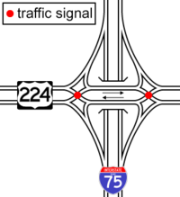
Diverging diamond interchange
Encyclopedia
A diverging diamond interchange is a rare form of diamond interchange
in which the two directions of traffic on the non-freeway road cross to the opposite side on both sides of the bridge at the freeway. It is unusual in that it requires traffic on the freeway overpass (or underpass) to briefly drive on the opposite side of the road from what they are accustomed. The diverging diamond interchange was listed by Popular Science
magazine as one of the best innovations in 2009 (engineering category) in "Best of What's New 2009".
Like the continuous flow intersection
, the diverging diamond interchange allows for two-phase operation at all signalized intersections within the interchange. This is a significant improvement in safety, since no left turns must clear opposing traffic and all movements are discrete, with most controlled by traffic signals. Additionally, the design can improve the efficiency of an interchange, as the lost time for various phases in the cycle can be redistributed as green time; there are only two clearance intervals (the time for traffic signals to change from green to yellow to red) instead of the six or more found in other interchange designs. Some of the intersections in the design can be unsignalized. The left turn from the freeway off-ramp, for example, can form an auxiliary lane that then becomes an exit-only lane for the entrance ramp to the freeway in the opposite direction. Omitting the traffic signals for the left turn movements off the freeway only works well with single left turns and when short queues exist within the interchange on the arterial street.
A design similar to a diverging diamond interchange can also be used as a free-flowing freeway-freeway junction by replacing the traffic lights with bridges, but then it is no longer a diverging diamond, but an obsolete form of directional interchange. In the United States
, such a design would violate newer federal requirements that all exit and entrance ramps be located on the right side of the freeway lanes.
in the communities of Versailles
, Le Perreux-sur-Marne
, and Seclin
(see External Links, below). (The ramps of the first two listed have been reconfigured to accommodate ramps of other interchanges, as seen in views on the Google Earth and Google Maps websites, but they continue to function as diverging diamond interchanges.) The interchange configuration was introduced to America in a paper submitted to the 2nd Urban Street Symposium held in Anaheim, California
in 2003 by Gilbert Chlewicki, a civil engineer from Baltimore, Maryland. In 2009 an interchange of this type was constructed in Springfield, Missouri
with additional interchanges constructed in North America in subsequent years(see below).
The interchange in Seclin (at 50°32′41"N 3°3′21"E) between the A1
and Route d'Avelin appears to have been made somewhat more specialized than in the diagram at right: eastbound traffic on Route d'Avelin intending to enter the A1 northbound must keep left and cross the northernmost bridge before turning left to proceed north onto A1; eastbound traffic continuing east on Route d'Avelin must select a single center lane, merge with A1 traffic that is exiting to proceed east, and cross a center bridge. All westbound traffic that is continuing west or turning south onto A1 uses the southernmost bridge.
Additional research was conducted by a partnership of the Virginia Polytechnic Institute and State University, the Turner-Fairbank Highway Research Center and a private consultant, and the results were published by Ohio Section of the Institute of Transportation Engineers.
, at the intersection of I-44
and MO-13 (at 37.2503°N 93.3107°W) began the week of January 12, 2009, and the interchange opened on Sunday, June 21, 2009, making it the first of its kind to be opened in the United States. This interchange was a conversion of an existing standard diamond interchange, and used the existing bridge. MoDOT completed a second diverging diamond interchange in Springfield at U.S. 60 and National Avenue in July 2010. There are also plans to reconfigure the intersection of U.S. 65 and Chestnut Expressway (Business Route 65) into a diverging diamond configuration.
The Utah Department of Transportation
completed its first diverging diamond interchange in August 2010 at Main Street in American Fork
. UDOT has three more open (see below)..
The Missouri Department of Transportation has completed the new diverging diamond interchange at I-270 and Dorsett Road in St. Louis County in late 2010. http://www.270dorsettpage.com/
The Tennessee Department of Transportation
designed a diverging diamond as part of the US 129 Bypass / Bessemer St / Middlesettlements Rd Interchange in Alcoa
. The interchange opened on December 12, 2010, becoming the 5th operational diverging diamond in the country.
In Lexington, Kentucky
, North America's sixth diverging diamond interchange opened on August 14, 2011, at the intersection of Harrodsburg Road and New Circle Road.
In Lehi, Utah
, North America's seventh diverging diamond interchange opened on August 15, 2011, at the intersection of the Timpagonos Highway (Utah 92) and Interstate 15. While still under construction, it began operating as a diverging diamond on this date. This was the first attempt in Utah to reconfigure an interchange to a diverging diamond using existing infrastructure.
In Salt Lake County, just outside Salt Lake, Utah, North America's eighth diverging diamond interchange opened on October 23, 2011, at the intersection of Utah 201 and the Bangarter Highway (Utah 154).
Utah opened another diverging diamond on November 7, 2011, at American Fork 500 East, as part of the reconstruction of I-15
. This was the 4th diverging diamond in Utah, and the 9th in the US.
Missouri also opened another diverging diamond in Kansas City on November 7, at the intersection if Interstate 435 and Front Street.
A diverging diamond opened on November 20, 2011 in Branson, Missouri
at the intersection of US 65 and Missouri 248. This is the 5th diverging diamond opened in Missouri, and the 11th in the US.
The Idaho Transportation Department
has proposed a diverging diamond interchange to replace the existing Chubbuck interchange on Interstate 86
. Construction is slated to begin in 2013 and finish in 2015.
A diverging-diamond interchange is nearing completion for the future interchange at US Hwy 52 and Olmsted County Rd. 12 in Pine Island, Minnesota
, just a few miles north of the city of Rochester
. It will be the first diverging-diamond in Minnesota. Two other projects are being studied, one in Sartell, near St. Cloud, and the other near Elko.
at the intersection of I-70 and Woods Chapel Road, at the intersection of I-435
and Front Street, and at the intersection of Botts Road and M-150; and one in St. Louis County
at the intersection of I-270
and Dorsett Road. The I-270 and Dorsett intersection opened for the first time on October 2010 becoming the 4th Diverging Diamond in the country. The city of Branson, Missouri
has decided to use the interchange at the intersection of MO 248 and US 65. Others are planned in Kansas City (I-29 & Tiffany Springs Parkway), Harrisonville (US 71 & Route 291), Grain Valley (I-70 & Route AA), Ozark, O'Fallon, Farmington, and St Peters.
The Virginia Department of Transportation
has proposed to reconstruct the 0.49 mile stretch of US-15
where it meets I-64
at Zion Crossroads
as a diverging diamond interchange. VDOT anticipates construction to begin in 2012. VDOT also proposes constructing a diverging diamond interchange at the intersection of U.S. 460
and Southgate Drive in Blacksburg
, replacing the only remaining at-grade intersection on the freeway-standard bypass of Blacksburg and Christiansburg.
This type of interchange was studied and rejected for use in Maryland
along the Baltimore-Washington Parkway
in Anne Arundel County
, near the Baltimore-Washington International Thurgood Marshall Airport
.
The Ontario Ministry of Transportation
is studying a diverging diamond as part of interchange upgrades at Highway 427 and Rathburn Road in Toronto
.
In February 2007, the Oregon Department of Transportation
accepted the DDI as the preferred alternative at Exit 24 (Fern Valley Road) along I-5
in Phoenix
, in the southern area of Oregon
. It will begin construction in 2012. A second diverging diamond interchange is being studied for Ashland.
In 2009, the Indiana Department of Transportation
announced plans to build a diverging diamond interchange near Watson, Indiana
in Clark county, as part of the Ohio River Bridges Project
. It will replace the current interchange at Indiana 265 and Indiana 62. The engineering for this project is almost completed. Another diverging diamond is being studied north of Fort Wayne, Indiana
.
In 2008, New York State Department of Transportation
(NYSDOT) announced that they were studying this alternative as a possibility for the I-590
/ Winton Rd. interchange in Rochester
. On February 19, 2010, NYSDOT officially announced plans to build the diverging diamond interchange, to be completed in Summer of 2012.
The Ohio Department of Transportation
(ODOT) has considered employing the interchange. ODOT planned to reconstruct the I-75
/US-224
/SR-15 interchange in Findlay
to this configuration, but reconsidered. The agency is currently considering the configuration for the I-480
/Tiedeman Road interchange in Brooklyn
.
Five diverging diamonds are proposed in Georgia
at the Ashford-Dunwoody Road interchange and bridge over I-285 in Atlanta, the SR 120/Duluth Highway bridge and interchange over SR 316 in Lawrenceville
, the SR 317/Lawrenceville-Suwanee Road interchange and bridge over I-85 in Suwanee
and for the Jimmy Carter Boulevard and Pleasant Hill Road interchanges and bridges over I-85 Interstate 85
in Gwinnett County, to the northeast of Atlanta.
On April 6, 2010, the Charlotte
suburb of Cornelius
approved plans by the North Carolina Department of Transportation
to convert the existing diamond interchange into a diverging diamond at the West Catawba/Catawba Exit (#28). This will be the first one in the state of North Carolina
. Work is expected to finish by 2012. North Carolina has also designed three other diverging diamonds in the Charlotte area, two on I-85 and one on I-485, and is studying diverging diamonds at Asheville, Kernersville, Lumberton, and Leland, for a total of eight projects in North Carolina.
Pennsylvania has two projects under study, Us 222 and Broadcasting Road at Reading, and US 222 and US 322 near Ephrata. Idaho has one near Pocatello, where US 91 meets I-86.
There is a sort of half-diverging-diamond interchange between Interstate 95
and Thurbers Ave. in Providence, Rhode Island
(at 41.800523°N 71.402823°W). The extension of Thurbers Ave. to US Route 1 being a one-way prevents it from being a full diverging diamond, but the interchange directly with Route 1 keeps almost full functionality, lacking only an easy-access interchange from US 1 to I-95 South.
A diverging diamond has been proposed in Illinois
at the interchange of IL-59 and I-88 in Naperville.
Florida is studying two locations near Sarasota, and a third farther south on I-75.
The Kansas Department of Transportation is currently working with Burns & McDonnell Engineering Company to design a Diverging Diamond Interchange for a new interchange on I-35 at Homestead Lane in Johnson County Kansas (http://i35swjohnsoncointerchange.ksdot.org/DDI.aspx)
The town of Colchester, Vermont
is considering a double-crossover diamond interchange as a replacement for the current intersection of exit 16 of Interstate 89
.
Diamond interchange
A diamond interchange is a common type of road junction, used where a freeway crosses a minor road. The freeway itself is grade-separated from the minor road, one crossing the other over a bridge...
in which the two directions of traffic on the non-freeway road cross to the opposite side on both sides of the bridge at the freeway. It is unusual in that it requires traffic on the freeway overpass (or underpass) to briefly drive on the opposite side of the road from what they are accustomed. The diverging diamond interchange was listed by Popular Science
Popular Science
Popular Science is an American monthly magazine founded in 1872 carrying articles for the general reader on science and technology subjects. Popular Science has won over 58 awards, including the ASME awards for its journalistic excellence in both 2003 and 2004...
magazine as one of the best innovations in 2009 (engineering category) in "Best of What's New 2009".
Like the continuous flow intersection
Continuous flow intersection
Continuous flow intersection , also called a crossover displaced left-turn , is an at-grade intersection that moves the turning vehicles, conflicting with the through-movements , out of the main intersection...
, the diverging diamond interchange allows for two-phase operation at all signalized intersections within the interchange. This is a significant improvement in safety, since no left turns must clear opposing traffic and all movements are discrete, with most controlled by traffic signals. Additionally, the design can improve the efficiency of an interchange, as the lost time for various phases in the cycle can be redistributed as green time; there are only two clearance intervals (the time for traffic signals to change from green to yellow to red) instead of the six or more found in other interchange designs. Some of the intersections in the design can be unsignalized. The left turn from the freeway off-ramp, for example, can form an auxiliary lane that then becomes an exit-only lane for the entrance ramp to the freeway in the opposite direction. Omitting the traffic signals for the left turn movements off the freeway only works well with single left turns and when short queues exist within the interchange on the arterial street.
A design similar to a diverging diamond interchange can also be used as a free-flowing freeway-freeway junction by replacing the traffic lights with bridges, but then it is no longer a diverging diamond, but an obsolete form of directional interchange. In the United States
United States
The United States of America is a federal constitutional republic comprising fifty states and a federal district...
, such a design would violate newer federal requirements that all exit and entrance ramps be located on the right side of the freeway lanes.
History
Prior to the last few years, the only known diverging diamond interchanges were located in FranceFrance
The French Republic , The French Republic , The French Republic , (commonly known as France , is a unitary semi-presidential republic in Western Europe with several overseas territories and islands located on other continents and in the Indian, Pacific, and Atlantic oceans. Metropolitan France...
in the communities of Versailles
Versailles
Versailles , a city renowned for its château, the Palace of Versailles, was the de facto capital of the kingdom of France for over a century, from 1682 to 1789. It is now a wealthy suburb of Paris and remains an important administrative and judicial centre...
, Le Perreux-sur-Marne
Le Perreux-sur-Marne
Le Perreux-sur-Marne is a commune in the Val-de-Marne department in the eastern suburbs of Paris, France. It is located from the center of Paris.-History:...
, and Seclin
Seclin
Seclin is a commune in the Nord department in northern France.It is part of the Urban Community of Lille Métropole.Ghana national football team footballer Andre Ayew was born in Seclin.-Twin towns — Sister cities:...
(see External Links, below). (The ramps of the first two listed have been reconfigured to accommodate ramps of other interchanges, as seen in views on the Google Earth and Google Maps websites, but they continue to function as diverging diamond interchanges.) The interchange configuration was introduced to America in a paper submitted to the 2nd Urban Street Symposium held in Anaheim, California
Anaheim, California
Anaheim is a city in Orange County, California. As of the 2010 United States Census, the city population was about 365,463, making it the most populated city in Orange County, the 10th most-populated city in California, and ranked 54th in the United States...
in 2003 by Gilbert Chlewicki, a civil engineer from Baltimore, Maryland. In 2009 an interchange of this type was constructed in Springfield, Missouri
Springfield, Missouri
Springfield is the third largest city in the U.S. state of Missouri and the county seat of Greene County. According to the 2010 census data, the population was 159,498, an increase of 5.2% since the 2000 census. The Springfield Metropolitan Area, population 436,712, includes the counties of...
with additional interchanges constructed in North America in subsequent years(see below).
The interchange in Seclin (at 50°32′41"N 3°3′21"E) between the A1
A1 autoroute (France)
The A1 Autoroute, also known as l'autoroute du Nord , is the busiest of France's autoroutes. With a length of , it connects Paris with the northern city of Lille. It is managed by the Société des Autoroutes du Nord et de l'Est de la France...
and Route d'Avelin appears to have been made somewhat more specialized than in the diagram at right: eastbound traffic on Route d'Avelin intending to enter the A1 northbound must keep left and cross the northernmost bridge before turning left to proceed north onto A1; eastbound traffic continuing east on Route d'Avelin must select a single center lane, merge with A1 traffic that is exiting to proceed east, and cross a center bridge. All westbound traffic that is continuing west or turning south onto A1 uses the southernmost bridge.
Additional research was conducted by a partnership of the Virginia Polytechnic Institute and State University, the Turner-Fairbank Highway Research Center and a private consultant, and the results were published by Ohio Section of the Institute of Transportation Engineers.
Advantages
- Provides for two-phase signals with short cycle lengths, significantly reducing delay.
- Reduced horizontal curvature reduces risk of off-road crashes.
- Increases the capacity of turning movements to and from the ramps.
- May potentially reduce the number of lanes on the crossroad, minimizing impacts to existing right-of-way.
- Substantially reduces the number of conflict points, thus theoretically improving safety.
- Theoretically improves pedestrian safety.
- Increases the capacity of an existing overpass or underpass, by removing the need for turn lanes.
Disadvantages
- Drivers may not be familiar with configuration, particularly with regards to merging maneuvers along the left side of the roadway or the reversed flow of traffic.
- Pedestrians would be required to cross free-flowing traffic on freeway ramps. This could be mitigated by signalizing all movements, without impacting the two-phase nature of the interchange’s signals.
- Free-flowing traffic in both directions on the non-freeway road is impossible, as the signals cannot be green at both intersections for both directions simultaneously—unless the two signalized intersections are replaced with underpass/overpass structures (an expensive proposition and usually not possible within the existing right of way of the non-freeway road).
- Exiting traffic cannot re-enter the freeway in the same direction without first leaving the interchange on the crossroad. This makes it harder to implement stops for express transit buses and means that drivers who accidentally take the wrong exit must turn around somewhere along the crossroad.
- Because of the above, emergency management can not use the exit and entrance ramps to allow freeway traffic to bypass a crash at the bridge.
- Also because of the above, an oversize load can not use the exit and entrance ramps to bypass a bridge that is too low.
- Also because of the above, a diverging diamond can not be the parent interchange for a rebound interchange without using collector-distributor roads (local-express lanesLocal-express lanesA Local-express lane system is an arrangement of roadways within a major highway providing one of more roadways for express lanes with a limited number of entrances and exits and also separate roadways for local or collector lanes which provide access to all interchanges...
).
Further considerations
- No standards currently exist for this design and the design is extremely dependent on site-specific conditions.
- There is no crash history available in the North America region, as no DDIs existed in North America until June 21, 2009, when North America's first DDI opened to traffic in Springfield, MissouriSpringfield, MissouriSpringfield is the third largest city in the U.S. state of Missouri and the county seat of Greene County. According to the 2010 census data, the population was 159,498, an increase of 5.2% since the 2000 census. The Springfield Metropolitan Area, population 436,712, includes the counties of...
. - Additional signage, lighting, and pavement markings are needed beyond the levels for a standard diamond interchange.
- Local road should be a low speed facility, preferably under 45 mph (20.1 m/s) posted speed on the crossroad approach. However this may be mitigated by utilizing a higher design speed for the crossing movements.
Use in North America
Construction of a diverging diamond interchange in the US in Springfield, MissouriSpringfield, Missouri
Springfield is the third largest city in the U.S. state of Missouri and the county seat of Greene County. According to the 2010 census data, the population was 159,498, an increase of 5.2% since the 2000 census. The Springfield Metropolitan Area, population 436,712, includes the counties of...
, at the intersection of I-44
Interstate 44
Interstate 44 is a major highway in the central United States. Its western terminus is in Wichita Falls, Texas at a concurrency with US 277, US 281 and US 287; its eastern terminus is at the Illinois state line on the Poplar Street Bridge over the Mississippi River in St...
and MO-13 (at 37.2503°N 93.3107°W) began the week of January 12, 2009, and the interchange opened on Sunday, June 21, 2009, making it the first of its kind to be opened in the United States. This interchange was a conversion of an existing standard diamond interchange, and used the existing bridge. MoDOT completed a second diverging diamond interchange in Springfield at U.S. 60 and National Avenue in July 2010. There are also plans to reconfigure the intersection of U.S. 65 and Chestnut Expressway (Business Route 65) into a diverging diamond configuration.
The Utah Department of Transportation
Utah Department of Transportation
The Utah Department of Transportation is an agency of the state government for the U.S. state of Utah. The agency is usually referred to by its initials UDOT . UDOT is charged with maintaining the network of state highways in Utah. The agency is headquartered in the Calvin L. Rampton state office...
completed its first diverging diamond interchange in August 2010 at Main Street in American Fork
American Fork, Utah
American Fork is a city in Utah County, Utah, United States, at the foot of Mount Timpanogos in the Wasatch Range, north of Utah Lake. It is part of the Provo–Orem, Utah Metropolitan Statistical Area. The population was 26,263 at the 2010 census, nearly a 20% growth since the 2000 census...
. UDOT has three more open (see below)..
The Missouri Department of Transportation has completed the new diverging diamond interchange at I-270 and Dorsett Road in St. Louis County in late 2010. http://www.270dorsettpage.com/
The Tennessee Department of Transportation
Tennessee Department of Transportation
The Tennessee Department of Transportation is a multimodal agency with statewide responsibilities in aviation, public transit, waterways and railroads...
designed a diverging diamond as part of the US 129 Bypass / Bessemer St / Middlesettlements Rd Interchange in Alcoa
Alcoa, Tennessee
Alcoa is a city in Blount County, Tennessee, United States, south of Knoxville. Its population was 7,744 at the 2000 census. It is part of the Knoxville, Tennessee Metropolitan Statistical Area....
. The interchange opened on December 12, 2010, becoming the 5th operational diverging diamond in the country.
In Lexington, Kentucky
Lexington, Kentucky
Lexington is the second-largest city in Kentucky and the 63rd largest in the US. Known as the "Thoroughbred City" and the "Horse Capital of the World", it is located in the heart of Kentucky's Bluegrass region...
, North America's sixth diverging diamond interchange opened on August 14, 2011, at the intersection of Harrodsburg Road and New Circle Road.
In Lehi, Utah
Lehi, Utah
-Attractions:Lehi Roller MillsLehi Roller Mills was founded in 1906 by a co-op of farmers. George G. Robinson purchased the mill in 1910, and since then it has remained in the family. It is run today by grandson R. Sherman Robinson....
, North America's seventh diverging diamond interchange opened on August 15, 2011, at the intersection of the Timpagonos Highway (Utah 92) and Interstate 15. While still under construction, it began operating as a diverging diamond on this date. This was the first attempt in Utah to reconfigure an interchange to a diverging diamond using existing infrastructure.
In Salt Lake County, just outside Salt Lake, Utah, North America's eighth diverging diamond interchange opened on October 23, 2011, at the intersection of Utah 201 and the Bangarter Highway (Utah 154).
Utah opened another diverging diamond on November 7, 2011, at American Fork 500 East, as part of the reconstruction of I-15
Interstate 15
Interstate 15 is the fourth-longest north–south Interstate Highway in the United States, traveling through the states of California, Nevada, Arizona, Utah, Idaho, and Montana from San Diego to the Canadian border...
. This was the 4th diverging diamond in Utah, and the 9th in the US.
Missouri also opened another diverging diamond in Kansas City on November 7, at the intersection if Interstate 435 and Front Street.
A diverging diamond opened on November 20, 2011 in Branson, Missouri
Branson, Missouri
Branson is a city in Taney County in the U.S. state of Missouri. It was named after Reuben Branson, postmaster and operator of a general store in the area in the 1880s....
at the intersection of US 65 and Missouri 248. This is the 5th diverging diamond opened in Missouri, and the 11th in the US.
The Idaho Transportation Department
Idaho Transportation Department
The Idaho Transportation Department is the State of Idaho governmental organization responsible for the current transportation infrastructure. This includes ongoing operations and maintenance; as well as planning for future needs of the state and its citizens...
has proposed a diverging diamond interchange to replace the existing Chubbuck interchange on Interstate 86
Interstate 86
Interstate 86 may refer to:*Interstate 86 , a partially completed route in New York and Pennsylvania, also known as the Southern Tier Expressway*Interstate 86 , a short route in Idaho...
. Construction is slated to begin in 2013 and finish in 2015.
A diverging-diamond interchange is nearing completion for the future interchange at US Hwy 52 and Olmsted County Rd. 12 in Pine Island, Minnesota
Pine Island, Minnesota
Pine Island is a city in Goodhue and Olmsted counties in the U.S. state of Minnesota. The population was 3,263 at the 2010 census. Most of Pine Island is in Goodhue County, but a small part extends into Olmsted County, making it part of the Rochester metropolitan area.The community has a strong...
, just a few miles north of the city of Rochester
Rochester, Minnesota
Rochester is a city in the U.S. state of Minnesota and is the county seat of Olmsted County. Located on both banks of the Zumbro River, The city has a population of 106,769 according to the 2010 United States Census, making it Minnesota's third-largest city and the largest outside of the...
. It will be the first diverging-diamond in Minnesota. Two other projects are being studied, one in Sartell, near St. Cloud, and the other near Elko.
Possible future use in North America
The Missouri Department of Transportation has plans to build additional diverging diamond interchanges across the state: In Kansas CityKansas City, Missouri
Kansas City, Missouri is the largest city in the U.S. state of Missouri and is the anchor city of the Kansas City Metropolitan Area, the second largest metropolitan area in Missouri. It encompasses in parts of Jackson, Clay, Cass, and Platte counties...
at the intersection of I-70 and Woods Chapel Road, at the intersection of I-435
Interstate 435
Interstate 435 is an Interstate Highway beltway that encircles much of the Kansas City, Missouri Metropolitan Area in the states of Kansas and Missouri, USA.- Route description :...
and Front Street, and at the intersection of Botts Road and M-150; and one in St. Louis County
St. Louis County, Missouri
St. Louis County is a county located in the U.S. state of Missouri. Its county seat is Clayton. St. Louis County is part of the St. Louis Metro Area wherein the independent City of St. Louis and its suburbs in St. Louis County, as well as the surrounding counties in both Missouri and Illinois all...
at the intersection of I-270
Interstate 270 (Illinois-Missouri)
Interstate 270 makes up a large portion of the outer belt freeway in the St. Louis, Missouri metropolitan area. The counterclockwise terminus of I-270 is at the junction with Interstate 55 in Mehlville, Missouri; the clockwise terminus of the freeway is at the junction with I-55 and I-70 north of...
and Dorsett Road. The I-270 and Dorsett intersection opened for the first time on October 2010 becoming the 4th Diverging Diamond in the country. The city of Branson, Missouri
Branson, Missouri
Branson is a city in Taney County in the U.S. state of Missouri. It was named after Reuben Branson, postmaster and operator of a general store in the area in the 1880s....
has decided to use the interchange at the intersection of MO 248 and US 65. Others are planned in Kansas City (I-29 & Tiffany Springs Parkway), Harrisonville (US 71 & Route 291), Grain Valley (I-70 & Route AA), Ozark, O'Fallon, Farmington, and St Peters.
The Virginia Department of Transportation
Virginia Department of Transportation
The Virginia Department of Transportation is the agency of state government responsible for transportation in the state of Virginia in the United States. Headquartered in Downtown Richmond, VDOT is responsible for building, maintaining, and operating the roads, bridges and tunnels in the...
has proposed to reconstruct the 0.49 mile stretch of US-15
U.S. Route 15
U.S. Route 15 is a -long United States highway, designated along South Carolina, North Carolina, Virginia, Maryland, Pennsylvania, and New York. The route is signed north–south, from U.S. Route 17 Alternate in Walterboro, South Carolina to Interstate 86 and NY 17 in Painted Post, New York.US...
where it meets I-64
Interstate 64
Interstate 64 is an Interstate Highway in the Midwestern and Southeastern United States. Its western terminus is at I-70, U.S. 40, and U.S. 61 in Wentzville, Missouri. Its eastern terminus is at an interchange with I-264 and I-664 at Bowers Hill in Chesapeake, Virginia. As I-64 is concurrent with...
at Zion Crossroads
Zion Crossroads, Virginia
Zion Crossroads is an unincorporated community in Louisa and Fluvanna counties, Virginia, at the intersection of James Madison Highway and Three Notch Road . About 2½ miles north is Green Springs National Historic Landmark District, a U.S. National Historic Landmark...
as a diverging diamond interchange. VDOT anticipates construction to begin in 2012. VDOT also proposes constructing a diverging diamond interchange at the intersection of U.S. 460
U.S. Route 460 in Virginia
U.S. Route 460 in Virginia runs east–west through the southern part of the state. It has two separate pieces in Virginia, joined by a relatively short section in West Virginia...
and Southgate Drive in Blacksburg
Blacksburg, Virginia
Blacksburg is an incorporated town located in Montgomery County, Virginia, United States, with a population of 42,620 at the 2010 census. Blacksburg, Christiansburg, and Radford are the three principal jurisdictions of the Blacksburg-Christiansburg-Radford Metropolitan Statistical Area which...
, replacing the only remaining at-grade intersection on the freeway-standard bypass of Blacksburg and Christiansburg.
This type of interchange was studied and rejected for use in Maryland
Maryland
Maryland is a U.S. state located in the Mid Atlantic region of the United States, bordering Virginia, West Virginia, and the District of Columbia to its south and west; Pennsylvania to its north; and Delaware to its east...
along the Baltimore-Washington Parkway
Baltimore-Washington Parkway
The Baltimore–Washington Parkway is a highway in the U.S. state of Maryland, running southwest from Baltimore to Washington, D.C. The road begins at an interchange with U.S. Route 50 and Maryland Route 201 near Cheverly in Prince George's County at the D.C...
in Anne Arundel County
Anne Arundel County, Maryland
Anne Arundel County is a county located in the U.S. state of Maryland. It is named for Anne Arundell , a member of the ancient family of Arundells in Cornwall, England and the wife of Cæcilius Calvert, 2nd Baron Baltimore. Its county seat is Annapolis, which is also the capital of the state...
, near the Baltimore-Washington International Thurgood Marshall Airport
Baltimore-Washington International Thurgood Marshall Airport
Baltimore/Washington International Thurgood Marshall Airport is an international airport serving the Baltimore-Washington Metropolitan Area in the United States. It is commonly called BWI, BWI Airport or BWI Marshall, BWI being an initialism for "Baltimore/Washington International" and the...
.
The Ontario Ministry of Transportation
Ministry of Transportation (Ontario)
The Ministry of Transportation of Ontario is the provincial ministry of the government of Ontario which is responsible for transport infrastructure and related law in Ontario. The ministry traces its roots back over a century to the 1890s, when the province began training Provincial Road Building...
is studying a diverging diamond as part of interchange upgrades at Highway 427 and Rathburn Road in Toronto
Toronto
Toronto is the provincial capital of Ontario and the largest city in Canada. It is located in Southern Ontario on the northwestern shore of Lake Ontario. A relatively modern city, Toronto's history dates back to the late-18th century, when its land was first purchased by the British monarchy from...
.
In February 2007, the Oregon Department of Transportation
Oregon Department of Transportation
The Oregon Department of Transportation is a department of the state government of the U.S. state of Oregon responsible for systems of transportation. It was first established in 1969. It had been preceded by the Oregon State Highway Department which, along with the Oregon State Highway...
accepted the DDI as the preferred alternative at Exit 24 (Fern Valley Road) along I-5
Interstate 5
Interstate 5 is the main Interstate Highway on the West Coast of the United States, running largely parallel to the Pacific Ocean coastline from Canada to Mexico . It serves some of the largest cities on the U.S...
in Phoenix
Phoenix, Oregon
Phoenix is a city in Jackson County, Oregon, United States. The population was 4,060 at the 2000 census and has grown to 4,855 people as of July 1, 2009.-History:...
, in the southern area of Oregon
Oregon
Oregon is a state in the Pacific Northwest region of the United States. It is located on the Pacific coast, with Washington to the north, California to the south, Nevada on the southeast and Idaho to the east. The Columbia and Snake rivers delineate much of Oregon's northern and eastern...
. It will begin construction in 2012. A second diverging diamond interchange is being studied for Ashland.
In 2009, the Indiana Department of Transportation
Indiana Department of Transportation
The Indiana Department of Transportation is a governmental agency of the U.S. state of Indiana charged with maintaining and regulating transportation and transportation related infrastructure such as state owned airports, state highways and state owned canals or railroads.-Districts:INDOT is...
announced plans to build a diverging diamond interchange near Watson, Indiana
Watson, Indiana
Watson is an unincorporated town in Utica Township, Clark County, Indiana....
in Clark county, as part of the Ohio River Bridges Project
Ohio River Bridges Project
The Ohio River Bridges Project is a controversial Louisville metropolitan area transportation project involving the reconstruction of the Kennedy Interchange , the completion of two new Ohio River bridges and the reconstruction of ramps on Interstate 65 between I-264 and downtown.One bridge will be...
. It will replace the current interchange at Indiana 265 and Indiana 62. The engineering for this project is almost completed. Another diverging diamond is being studied north of Fort Wayne, Indiana
Fort Wayne, Indiana
Fort Wayne is a city in the US state of Indiana and the county seat of Allen County. The population was 253,691 at the 2010 Census making it the 74th largest city in the United States and the second largest in Indiana...
.
In 2008, New York State Department of Transportation
New York State Department of Transportation
The New York State Department of Transportation is responsible for the development and operation of highways, railroads, mass transit systems, ports, waterways and aviation facilities in the U.S...
(NYSDOT) announced that they were studying this alternative as a possibility for the I-590
Interstate 590
Interstate 590 is a north–south auxiliary Interstate Highway that serves the immediate southeastern suburbs of the city of Rochester, New York, in the United States. It extends for from an interchange with I-390 in Brighton to the Can of Worms, a complex interchange connecting I-590 to I-490...
/ Winton Rd. interchange in Rochester
Rochester, New York
Rochester is a city in Monroe County, New York, south of Lake Ontario in the United States. Known as The World's Image Centre, it was also once known as The Flour City, and more recently as The Flower City...
. On February 19, 2010, NYSDOT officially announced plans to build the diverging diamond interchange, to be completed in Summer of 2012.
The Ohio Department of Transportation
Ohio Department of Transportation
The Ohio Department of Transportation is the organization of state government responsible for developing and maintaining all state and federal roadways in the state of Ohio with exception of the Ohio Turnpike. In addition to highways, the department also helps develop public transportation and...
(ODOT) has considered employing the interchange. ODOT planned to reconstruct the I-75
Interstate 75 in Ohio
In the U.S. state of Ohio, Interstate 75 runs from Cincinnati to Toledo by way of Dayton. I-75 enters Ohio concurrent with I-71 from Kentucky on the Brent Spence Bridge over the Ohio River and into the Bluegrass region...
/US-224
U.S. Route 224
U.S. Route 224 is a spur of U.S. Route 24. It currently runs for 289 miles from New Castle, Pennsylvania at Pennsylvania Route 18 to Huntington, Indiana at U.S. Route 24. It passes through the states of Pennsylvania, Ohio and Indiana...
/SR-15 interchange in Findlay
Findlay, Ohio
As of the census of 2000, there were 38,967 people, 15,905 households, and 10,004 families residing in the city. The population density was 2,266.3 people per square mile . There were 17,152 housing units at an average density of 997.6 per square mile...
to this configuration, but reconsidered. The agency is currently considering the configuration for the I-480
Interstate 480 (Ohio)
Interstate 480 is a loop highway that connects the Ohio Turnpike with suburban Cleveland, Ohio. The highway is officially designated the Outerbelt South Freeway, but it is rarely referred to by that name....
/Tiedeman Road interchange in Brooklyn
Brooklyn, Ohio
Brooklyn is a city in Cuyahoga County, Ohio, United States. The population was 11,169 at the 2010 census.-Geography:Brooklyn is located at ....
.
Five diverging diamonds are proposed in Georgia
Georgia (U.S. state)
Georgia is a state located in the southeastern United States. It was established in 1732, the last of the original Thirteen Colonies. The state is named after King George II of Great Britain. Georgia was the fourth state to ratify the United States Constitution, on January 2, 1788...
at the Ashford-Dunwoody Road interchange and bridge over I-285 in Atlanta, the SR 120/Duluth Highway bridge and interchange over SR 316 in Lawrenceville
Lawrenceville, Georgia
Lawrenceville is a city in and the county seat of Gwinnett County, Georgia, in the United States. The Census Bureau estimates the 2008 population at 29,258...
, the SR 317/Lawrenceville-Suwanee Road interchange and bridge over I-85 in Suwanee
Suwanee, Georgia
As of 2010 Suwanee had a population of 15,355. The racial and ethnic composition of the population was 67.4% white, 10.8% black or African American, 0.1% Native American, 18.0% Asian, 0.1% Pacific Islander, 1.3% reporting some other race and 2.3% reporting two or more races...
and for the Jimmy Carter Boulevard and Pleasant Hill Road interchanges and bridges over I-85 Interstate 85
Interstate 85
Interstate 85 is a major interstate highway in the Southeastern United States. Its current southern terminus is at an interchange with Interstate 65 in Montgomery, Alabama; its northern terminus interchanges with Interstate 95 in Petersburg, Virginia, near Richmond...
in Gwinnett County, to the northeast of Atlanta.
On April 6, 2010, the Charlotte
CHARLOTTE
- CHARLOTTE :CHARLOTTE is an American blues-based hard rock band that formed in Los Angeles, California in 1986. Currently, they are signed to indie label, Eonian Records, under which they released their debut cd, Medusa Groove, in 2010. Notable Charlotte songs include 'Siren', 'Little Devils',...
suburb of Cornelius
Cornelius, North Carolina
Cornelius is a town located along Lake Norman in northern Mecklenburg County, North Carolina, United States. The population was 11,969 at the 2000 census.-Geography:Cornelius is located along Lake Norman in northern Mecklenburg County...
approved plans by the North Carolina Department of Transportation
North Carolina Department of Transportation
The North Carolina Department of Transportation is responsible for building, repairing, and operating highways, bridges, and other modes of transportation, including ferries in the U.S. state of North Carolina.-History:...
to convert the existing diamond interchange into a diverging diamond at the West Catawba/Catawba Exit (#28). This will be the first one in the state of North Carolina
North Carolina
North Carolina is a state located in the southeastern United States. The state borders South Carolina and Georgia to the south, Tennessee to the west and Virginia to the north. North Carolina contains 100 counties. Its capital is Raleigh, and its largest city is Charlotte...
. Work is expected to finish by 2012. North Carolina has also designed three other diverging diamonds in the Charlotte area, two on I-85 and one on I-485, and is studying diverging diamonds at Asheville, Kernersville, Lumberton, and Leland, for a total of eight projects in North Carolina.
Pennsylvania has two projects under study, Us 222 and Broadcasting Road at Reading, and US 222 and US 322 near Ephrata. Idaho has one near Pocatello, where US 91 meets I-86.
There is a sort of half-diverging-diamond interchange between Interstate 95
Interstate 95
Interstate 95 is the main highway on the East Coast of the United States, running parallel to the Atlantic Ocean from Maine to Florida and serving some of the most populated urban areas in the country, including Boston, Providence, New Haven, New York City, Newark, Philadelphia, Baltimore,...
and Thurbers Ave. in Providence, Rhode Island
Providence, Rhode Island
Providence is the capital and most populous city of Rhode Island and was one of the first cities established in the United States. Located in Providence County, it is the third largest city in the New England region...
(at 41.800523°N 71.402823°W). The extension of Thurbers Ave. to US Route 1 being a one-way prevents it from being a full diverging diamond, but the interchange directly with Route 1 keeps almost full functionality, lacking only an easy-access interchange from US 1 to I-95 South.
A diverging diamond has been proposed in Illinois
Illinois
Illinois is the fifth-most populous state of the United States of America, and is often noted for being a microcosm of the entire country. With Chicago in the northeast, small industrial cities and great agricultural productivity in central and northern Illinois, and natural resources like coal,...
at the interchange of IL-59 and I-88 in Naperville.
Florida is studying two locations near Sarasota, and a third farther south on I-75.
The Kansas Department of Transportation is currently working with Burns & McDonnell Engineering Company to design a Diverging Diamond Interchange for a new interchange on I-35 at Homestead Lane in Johnson County Kansas (http://i35swjohnsoncointerchange.ksdot.org/DDI.aspx)
The town of Colchester, Vermont
Colchester, Vermont
Colchester is a town in Chittenden County, Vermont, United States. The population was 17,067 at the 2010 census. It is the fourth-largest municipality and second-largest town in Vermont by population.-Geography:...
is considering a double-crossover diamond interchange as a replacement for the current intersection of exit 16 of Interstate 89
Interstate 89
Interstate 89 is an interstate highway in the New England region of the United States travelling between Bow, New Hampshire and Highgate Springs, Vermont. As with all odd-numbered primary interstates, I-89 is signed as a north–south highway...
.
See also
- Double Crossover Merging InterchangeDouble Crossover Merging InterchangeA Double Crossover Merging Interchange is a new type of interchange. The traffic lane patterns lane of the DCMI’s offers a system of creating a high volume interchange that allows traffic to continuously flow without the need for costly elevated “fly-over” roadway bridges, and uses less lane area...
- Continuous-flow intersection
- JughandleJughandleA jughandle is a type of ramp or slip road that changes the way traffic turns left at at-grade intersections. Instead of a standard left turn being made from the left lane, left-turning traffic uses a ramp on the right side of the road...
- Hook turnHook turnA hook turn is a traffic-control mechanism where cars that would normally have to turn across oncoming traffic are made to turn across all lanes of traffic instead....
- Michigan leftMichigan leftA Michigan left is an at-grade intersection design which replaces each left turn with a permutation of a U-turn and a right turn. The design was given the name due to its frequent use along Michigan roads and highways since the late 1960s. In other contexts, the intersection is called a median...
- SuperstreetSuperstreetA superstreet is a type of road intersection that is a variation of the Michigan left. In this configuration, traffic on the minor road is not permitted to proceed straight across the major road or highway; traffic wishing to turn left or go straight must turn right onto the major road, make a...
Further reading
- "Drivers' Evaluation of the Diverging Diamond Interchange" (publication number FHWA-HRT-07-048). Turner-Fairbank Highway Research Center, Federal Highway AdministrationFederal Highway AdministrationThe Federal Highway Administration is a division of the United States Department of Transportation that specializes in highway transportation. The agency's major activities are grouped into two "programs," the Federal-aid Highway Program and the Federal Lands Highway Program...
- "Diamond interchange planned for So. Indiana project", courier-journal.com, January 19, 2010
- "Missouri's Experience with a Diverging Diamond Interchange: Lessons Learned, MoDOT Innovations Library, May 2010
External links
- Utah Department of Transportation Timpanogos Highway Diverging Diamond Interchange animation video
- Transportation engineers discuss the design of the fifth U.S. DDI in Alcoa, TN
- Video of Double Crossover Diamond Interchange (new name for DDI) currently under construction in Lexington, Kentucky.
- Video of Paramics Traffic Simualtion software modeling a Double Crossover Diamond Interchange
- Images of Diverging Diamond Interchange in Springfield, Missouri the first in North America.
- Animation of diverging diamond interchange at Dorsett and Interstate 270 in St. Louis.
- Web page for Springfield Missouri Diverging Diamond Interchange
- Web page for Missouri DDI at I-435 and Front st. Map of a diverging diamond interchange in VersaillesVersaillesVersailles , a city renowned for its château, the Palace of Versailles, was the de facto capital of the kingdom of France for over a century, from 1682 to 1789. It is now a wealthy suburb of Paris and remains an important administrative and judicial centre...
, FranceFranceThe French Republic , The French Republic , The French Republic , (commonly known as France , is a unitary semi-presidential republic in Western Europe with several overseas territories and islands located on other continents and in the Indian, Pacific, and Atlantic oceans. Metropolitan France...
Map of a diverging diamond interchange in Le Perreux-sur-MarneLe Perreux-sur-MarneLe Perreux-sur-Marne is a commune in the Val-de-Marne department in the eastern suburbs of Paris, France. It is located from the center of Paris.-History:...
, FranceFranceThe French Republic , The French Republic , The French Republic , (commonly known as France , is a unitary semi-presidential republic in Western Europe with several overseas territories and islands located on other continents and in the Indian, Pacific, and Atlantic oceans. Metropolitan France...
Map of a diverging diamond interchange in SeclinSeclinSeclin is a commune in the Nord department in northern France.It is part of the Urban Community of Lille Métropole.Ghana national football team footballer Andre Ayew was born in Seclin.-Twin towns — Sister cities:...
, FranceFranceThe French Republic , The French Republic , The French Republic , (commonly known as France , is a unitary semi-presidential republic in Western Europe with several overseas territories and islands located on other continents and in the Indian, Pacific, and Atlantic oceans. Metropolitan France...