

Michigan left
Encyclopedia
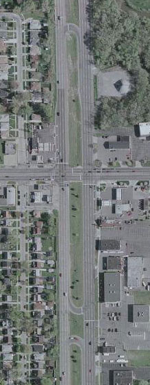
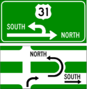
A Michigan left is an at-grade intersection design which replaces each left turn with a permutation of a U-turn and a right turn. The design was given the name due to its frequent use along Michigan
roads and highways since the late 1960s. In other contexts, the intersection is called a median U-turn crossover or median U-turn. The design is also sometimes referred to as a boulevard turnaround or a thru turn intersection.
s where at least one road is a divided highway
or boulevard
, and left turns onto—and usually from—the divided highway are prohibited. In almost every case, the divided highway is multi-laned in both directions. When on the secondary road, drivers are directed to turn right. Within 1/4 mi, they queue into a designated U-turn (or cross-over) lane in the median. When traffic clears they complete the U-turn and go back through the intersection. Additionally, the U-turn lane is designed for one-way traffic. Similarly, traffic on the divided highway cannot turn left at an intersection with a cross street. Instead, drivers are instructed to "overshoot" the intersection, go through the U-turn lane, come back to the intersection from the opposite direction, and turn right.
When vehicles enter the cross-over area, unless markings on the ground indicate two turning lanes in the cross-over, drivers form one lane. A cross-over with two lanes is designed at high-volume cross-overs, or when the right lane turns onto an intersecting street. In this case, the right lane is reserved for vehicles completing the design. Most cross overs must be made large enough for semi-trailer trucks to complete the cross over. This large cross-over area often leads to two vehicles incorrectly lining up at a single cross-over.
 The Michigan Department of Transportation
first used the design at the intersection of 8 Mile Road (M-102
) and Livernois Avenue (42.4461°N 83.141°W) in Detroit in the early 1960s. The increase in traffic flow and reduction in accidents was so dramatic that over 700 similar intersections have been deployed throughout the state since then.
In 2009 the Victorian
state government in Australia
announced the introduction of a "P-turn", similar to the Michigan left, in the southern Melbourne
suburb of Frankston
. Traffic in Australia drives on the left: the P-turn requires right-turning vehicles to turn left then make a U-turn.
The design has been proposed in Toronto
to relieve motorists who wish to make a left-turn on roadways which will contain a proposed streetcar line by the Transit City
project.
In Mexico, Guadalajara has a grade-separated variation of this setup in the intersection of Mariano Otero Avenue and Manuel Gómez Morín Beltway (20.630666°N 103.434981°W). Traffic flowing through Mariano Otero is routed through an overpass above the beltway, with two access roads allowing right turn on all four possible directions; the U-turns, meanwhile, are built underneath the beltway and allow the left turn from Mariano Otero avenue to the beltway.
Brazil is also known to utilize this setup especially in Sao Paulo
.
The city of Plano
was the first city in Texas
to use a Michigan left. One was built in mid-2010 at the intersection of Preston Road and Legacy Drive.
The city of Draper
, a suburb of Salt Lake City, Utah
, announced in 2011 that it would be building Utah's first "Thru-Turn" at the intersection of 12300 South and State Street, just off Interstate 15
through Salt Lake County. Construction is scheduled to begin in summer 2011 and be operational by Jan 1, 2012.
 This type of intersection configuration, as with any engineered solution to a traffic problem, carries with it certain advantages and disadvantages and has been subject to several studies.
Studies have shown a major reduction in left-turn collisions and a minor reduction in merging and diverging collisions, due to the shifting of left turns outside the main intersection. In addition it reduces the number of different traffic light
phases, significantly increasing traffic flow. Since separate phases are no longer needed for left turns, this increases green time for through traffic. The effect on turning traffic is mixed. Consequently, the timing of traffic signals along a highway featuring the design is made easier by the elimination of left-turn phases both on that highway and along intersecting roadways contributing to the reduction of travel times and the increased capacity of those roadways. Finally it has been shown to enhance safety to pedestrians crossing either street at an intersection featuring the design, since they only encounter through traffic and vehicles making right turns. The left-turning movement, having been eliminated, removes one source of potential vehicle-pedestrian conflict.
Michigan
Michigan is a U.S. state located in the Great Lakes Region of the United States of America. The name Michigan is the French form of the Ojibwa word mishigamaa, meaning "large water" or "large lake"....
roads and highways since the late 1960s. In other contexts, the intersection is called a median U-turn crossover or median U-turn. The design is also sometimes referred to as a boulevard turnaround or a thru turn intersection.
Description
The design occurs at intersectionIntersection (road)
An intersection is a road junction where two or more roads either meet or cross at grade . An intersection may be 3-way - a T junction or fork, 4-way - a crossroads, or 5-way or more...
s where at least one road is a divided highway
Divided Highway
Divided Highway is a compilation album by American rock band The Doobie Brothers, released in 2003. . All tracks are taken from the albums Cycles and Brotherhood .-Track listing:...
or boulevard
Boulevard
A Boulevard is type of road, usually a wide, multi-lane arterial thoroughfare, divided with a median down the centre, and roadways along each side designed as slow travel and parking lanes and for bicycle and pedestrian usage, often with an above-average quality of landscaping and scenery...
, and left turns onto—and usually from—the divided highway are prohibited. In almost every case, the divided highway is multi-laned in both directions. When on the secondary road, drivers are directed to turn right. Within 1/4 mi, they queue into a designated U-turn (or cross-over) lane in the median. When traffic clears they complete the U-turn and go back through the intersection. Additionally, the U-turn lane is designed for one-way traffic. Similarly, traffic on the divided highway cannot turn left at an intersection with a cross street. Instead, drivers are instructed to "overshoot" the intersection, go through the U-turn lane, come back to the intersection from the opposite direction, and turn right.
When vehicles enter the cross-over area, unless markings on the ground indicate two turning lanes in the cross-over, drivers form one lane. A cross-over with two lanes is designed at high-volume cross-overs, or when the right lane turns onto an intersecting street. In this case, the right lane is reserved for vehicles completing the design. Most cross overs must be made large enough for semi-trailer trucks to complete the cross over. This large cross-over area often leads to two vehicles incorrectly lining up at a single cross-over.
Locations
Michigan Department of Transportation
The Michigan Department of Transportation is a constitutional government agency in the US state of Michigan. The primary purpose of MDOT is to maintain the Michigan State Trunkline Highway System which includes all Interstate, US and state highways in Michigan with the exception of the Mackinac...
first used the design at the intersection of 8 Mile Road (M-102
M-102 (Michigan highway)
M-102 is a state trunkline in the US state of Michigan, running along the northern boundary of Detroit. It is known as 8 Mile Road for most of its length. As part of the land surveying of the state, the road follows the Michigan Baseline, and it is called Base Line Road in places. M-102 is the...
) and Livernois Avenue (42.4461°N 83.141°W) in Detroit in the early 1960s. The increase in traffic flow and reduction in accidents was so dramatic that over 700 similar intersections have been deployed throughout the state since then.
In 2009 the Victorian
Victoria (Australia)
Victoria is the second most populous state in Australia. Geographically the smallest mainland state, Victoria is bordered by New South Wales, South Australia, and Tasmania on Boundary Islet to the north, west and south respectively....
state government in Australia
Australia
Australia , officially the Commonwealth of Australia, is a country in the Southern Hemisphere comprising the mainland of the Australian continent, the island of Tasmania, and numerous smaller islands in the Indian and Pacific Oceans. It is the world's sixth-largest country by total area...
announced the introduction of a "P-turn", similar to the Michigan left, in the southern Melbourne
Melbourne
Melbourne is the capital and most populous city in the state of Victoria, and the second most populous city in Australia. The Melbourne City Centre is the hub of the greater metropolitan area and the Census statistical division—of which "Melbourne" is the common name. As of June 2009, the greater...
suburb of Frankston
Frankston, Victoria
Frankston is a suburb within the Greater Melbourne metropolitan area in Victoria, Australia. It is located 40 km southeast of the state capital Melbourne at the southernmost edge of Greater Melbourne, near the beginnings of the Mornington Peninsula...
. Traffic in Australia drives on the left: the P-turn requires right-turning vehicles to turn left then make a U-turn.
The design has been proposed in Toronto
Toronto
Toronto is the provincial capital of Ontario and the largest city in Canada. It is located in Southern Ontario on the northwestern shore of Lake Ontario. A relatively modern city, Toronto's history dates back to the late-18th century, when its land was first purchased by the British monarchy from...
to relieve motorists who wish to make a left-turn on roadways which will contain a proposed streetcar line by the Transit City
Transit City
Transit City was a plan for developing public transport in Toronto, Ontario, Canada. It was first proposed and announced by then-Toronto Mayor David Miller and Chair of the Toronto Transit Commission Adam Giambrone on March 16, 2007...
project.
In Mexico, Guadalajara has a grade-separated variation of this setup in the intersection of Mariano Otero Avenue and Manuel Gómez Morín Beltway (20.630666°N 103.434981°W). Traffic flowing through Mariano Otero is routed through an overpass above the beltway, with two access roads allowing right turn on all four possible directions; the U-turns, meanwhile, are built underneath the beltway and allow the left turn from Mariano Otero avenue to the beltway.
Brazil is also known to utilize this setup especially in Sao Paulo
São Paulo
São Paulo is the largest city in Brazil, the largest city in the southern hemisphere and South America, and the world's seventh largest city by population. The metropolis is anchor to the São Paulo metropolitan area, ranked as the second-most populous metropolitan area in the Americas and among...
.
The city of Plano
Plano, Texas
Plano is a city in the state of Texas, located mostly within Collin County. The city's population was 259,841 at the 2010 census, making it the ninth-largest city in Texas and the 71st most populous city in the United States. Plano is located within the metropolitan area commonly referred to as...
was the first city in Texas
Texas
Texas is the second largest U.S. state by both area and population, and the largest state by area in the contiguous United States.The name, based on the Caddo word "Tejas" meaning "friends" or "allies", was applied by the Spanish to the Caddo themselves and to the region of their settlement in...
to use a Michigan left. One was built in mid-2010 at the intersection of Preston Road and Legacy Drive.
The city of Draper
Draper, Utah
Draper is a city in Salt Lake and Utah Counties in the U.S. state of Utah, located about south of Salt Lake City along the Wasatch Front. Between 1990 and 2000 Draper was Utah's fastest-growing city over 5,000 people . Its population in 1990 was 7,143 and had grown to 25,220 by the 2000 census...
, a suburb of Salt Lake City, Utah
Salt Lake City, Utah
Salt Lake City is the capital and the most populous city of the U.S. state of Utah. The name of the city is often shortened to Salt Lake or SLC. With a population of 186,440 as of the 2010 Census, the city lies in the Salt Lake City metropolitan area, which has a total population of 1,124,197...
, announced in 2011 that it would be building Utah's first "Thru-Turn" at the intersection of 12300 South and State Street, just off Interstate 15
Interstate 15 in Utah
In the U.S. state of Utah, Interstate 15 runs north–south through the southwestern and central portions of the state, passing through many of the population centers of that state, including St. George, Provo, Salt Lake City, and Ogden, the latter three being part of the urban area known as...
through Salt Lake County. Construction is scheduled to begin in summer 2011 and be operational by Jan 1, 2012.
Applicable traffic studies
Studies have shown a major reduction in left-turn collisions and a minor reduction in merging and diverging collisions, due to the shifting of left turns outside the main intersection. In addition it reduces the number of different traffic light
Traffic light
Traffic lights, which may also be known as stoplights, traffic lamps, traffic signals, signal lights, robots or semaphore, are signalling devices positioned at road intersections, pedestrian crossings and other locations to control competing flows of traffic...
phases, significantly increasing traffic flow. Since separate phases are no longer needed for left turns, this increases green time for through traffic. The effect on turning traffic is mixed. Consequently, the timing of traffic signals along a highway featuring the design is made easier by the elimination of left-turn phases both on that highway and along intersecting roadways contributing to the reduction of travel times and the increased capacity of those roadways. Finally it has been shown to enhance safety to pedestrians crossing either street at an intersection featuring the design, since they only encounter through traffic and vehicles making right turns. The left-turning movement, having been eliminated, removes one source of potential vehicle-pedestrian conflict.
See also
- Continuous-flow intersection
- Diverging diamond interchangeDiverging diamond interchangeA diverging diamond interchange is a rare form of diamond interchange in which the two directions of traffic on the non-freeway road cross to the opposite side on both sides of the bridge at the freeway. It is unusual in that it requires traffic on the freeway overpass to briefly drive on the...
- Hook turnHook turnA hook turn is a traffic-control mechanism where cars that would normally have to turn across oncoming traffic are made to turn across all lanes of traffic instead....
- JughandleJughandleA jughandle is a type of ramp or slip road that changes the way traffic turns left at at-grade intersections. Instead of a standard left turn being made from the left lane, left-turning traffic uses a ramp on the right side of the road...
- Pittsburgh leftPittsburgh LeftThe Pittsburgh left is a colloquial term for the driving practice of the first left-turning vehicle taking precedence over vehicles going straight through an intersection, associated with the Pittsburgh, Pennsylvania area. The practice is also referred to as a Boston left...
- SuperstreetSuperstreetA superstreet is a type of road intersection that is a variation of the Michigan left. In this configuration, traffic on the minor road is not permitted to proceed straight across the major road or highway; traffic wishing to turn left or go straight must turn right onto the major road, make a...