

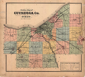
Defunct townships of Cuyahoga County, Ohio
Encyclopedia
Ohio
Ohio is a Midwestern state in the United States. The 34th largest state by area in the U.S.,it is the 7th‑most populous with over 11.5 million residents, containing several major American cities and seven metropolitan areas with populations of 500,000 or more.The state's capital is Columbus...
, United States
United States
The United States of America is a federal constitutional republic comprising fifty states and a federal district...
is divided into twenty-one townships.
When Cuyahoga County
Cuyahoga County, Ohio
Cuyahoga County is a county located in the state of Ohio, United States. It is the most populous county in Ohio; as of the 2010 census, the population was 1,280,122. Its county seat is Cleveland. Cuyahoga County is part of Greater Cleveland, a metropolitan area, and Northeast Ohio, a...
was founded, it was divided into civil township
Civil township
A civil township is a widely used unit of local government in the United States, subordinate to, and geographic divisions of, a county. Specific responsibilities and the degree of autonomy vary based on each state. Civil townships are distinct from survey townships, but in states that have both,...
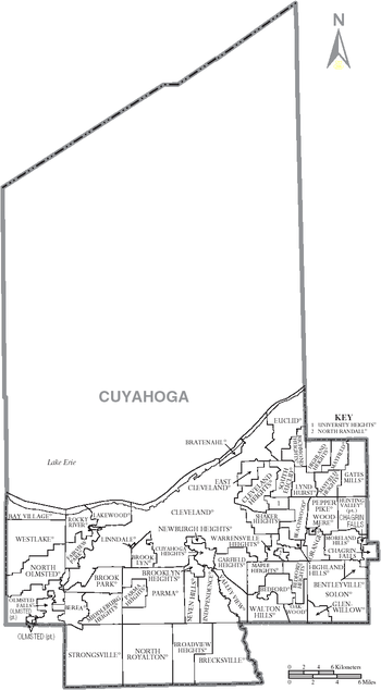
s for purposes of rural government, as were other Ohio counties. By 1990, this county was the most urbanized county in Ohio
Ohio
Ohio is a Midwestern state in the United States. The 34th largest state by area in the U.S.,it is the 7th‑most populous with over 11.5 million residents, containing several major American cities and seven metropolitan areas with populations of 500,000 or more.The state's capital is Columbus...
, and as a result, most of its townships have been annexed
Municipal annexation in the United States
Municipal annexation is a process whereby a city government expands the city limits into adjacent areas not already incorporated into cities, villages or other municipalities, and sometimes when they were...
by the city of Cleveland
Cleveland, Ohio
Cleveland is a city in the U.S. state of Ohio and is the county seat of Cuyahoga County, the most populous county in the state. The city is located in northeastern Ohio on the southern shore of Lake Erie, approximately west of the Pennsylvania border...
or one of the other municipalities in Cuyahoga County. In Ohio, when the entirety of a civil township has been annexed by one or more municipalities, it ceases to have governmental powers and becomes a paper township
Paper township
A paper township is a type of civil township under Ohio law that does not act as a functioning unit of civil government. Such townships usually exist due to annexation by cities and villages.-Defunct townships:...
, existing on maps but possessing no governmental powers. Today, nineteen of Cuyahoga County's townships are paper townships, with only a part of Olmsted Township
Olmsted Township, Cuyahoga County, Ohio
Olmsted Township is a township located in Cuyahoga County, Ohio, United States. As of the 2010 Census, the township had a population of 13,513. It is one of only two civil townships remaining in Cuyahoga County and the only Olmsted Township statewide....
and a tiny section of Chagrin Falls Township
Chagrin Falls Township, Cuyahoga County, Ohio
Chagrin Falls Township is a township located in Cuyahoga County, Ohio, United States. As of the 2010 census, the township had a total population of 4,233, which includes the village of Chagrin Falls. The portion of the township outside the village limits had a population of 120 at the 2010 census...
remaining as civil townships — just 10.5 mi² (16.9 km²) of Cuyahoga County's total area of 458 mi² (737.75 km²).
Bedford Township
Although the land that became Bedford Township was bought by the Connecticut Land CompanyConnecticut Land Company
The Connecticut Land Company was formed in the late eighteenth century to survey and encourage settlement in the Connecticut Western Reserve, part of the Old Northwest Territory. The Western Reserve is located in Northeast Ohio with its hub being Cleveland. In 1795, the Connecticut Land Company...
in 1795, no white settlers came until Elijah Nobles arrived in 1813, and the first permanent settler came only in 1821. The township was organized on April 7, 1823, and the city of Bedford
Bedford, Ohio
Bedford is a city in Cuyahoga County, Ohio, United States. The population was 13,074 at the 2010 census. It is an eastern suburb of Cleveland.-Geography:Bedford is located at ....
was incorporated as a village on March 15, 1837. Throughout the rest of the century, the township remained an agricultural area with little industry, but major industries began to arrive in the early twentieth century.
1915 saw the first political change in the township since 1837, when Maple Heights
Maple Heights, Ohio
As of the census of 2000, there were 26,156 people, 10,489 households, and 6,964 families residing in the city. The population density was 5,039.1 people per square mile . There were 10,935 housing units at an average density of 2,106.7 per square mile...
was incorporated as a village. The rest of the township remained unincorporated until 1951, when it was divided between Bedford Heights
Bedford Heights, Ohio
-External links:*...
, Oakwood
Oakwood, Cuyahoga County, Ohio
Oakwood is a village in Cuyahoga County, Ohio, United States. The population was 3,667 at the 2010 census.-Geography:Oakwood is located at .According to the United States Census Bureau, the village has a total area of , all of it land.-Demographics:...
, and Walton Hills
Walton Hills, Ohio
Walton Hills is a village in Cuyahoga County, Ohio, United States. The population was 2,281 at the 2010 census.-Geography:Walton Hills is located at ....
. As of the 2000 census
United States Census, 2000
The Twenty-second United States Census, known as Census 2000 and conducted by the Census Bureau, determined the resident population of the United States on April 1, 2000, to be 281,421,906, an increase of 13.2% over the 248,709,873 persons enumerated during the 1990 Census...
, these cities and villages had a total population of 57,812.
Brecksville Township
Brecksville Township was formed in 1807 and named for MassachusettsMassachusetts
The Commonwealth of Massachusetts is a state in the New England region of the northeastern United States of America. It is bordered by Rhode Island and Connecticut to the south, New York to the west, and Vermont and New Hampshire to the north; at its east lies the Atlantic Ocean. As of the 2010...
resident John Breck, the owner of significant lands in that vicinity. It included the modern community of Brecksville
Brecksville, Ohio
-External links:* * *...
and part of Broadview Heights
Broadview Heights, Ohio
As of the census of 2000, there were 15,967 people, 6,411 households, and 4,378 families residing in the city. The population density was 1,222.7 people per square mile . There were 6,803 housing units at an average density of 521.0 per square mile...
. The township was first settled in 1811 by the family of one Seth Payne, who came from Williamsburg
Williamsburg, Massachusetts
Williamsburg is a town in Hampshire County, Massachusetts, United States. The population was 2,482 at the 2010 census. It is part of the Springfield, Massachusetts Metropolitan Statistical Area.-The Mill River Flood:...
, Massachusetts
Massachusetts
The Commonwealth of Massachusetts is a state in the New England region of the northeastern United States of America. It is bordered by Rhode Island and Connecticut to the south, New York to the west, and Vermont and New Hampshire to the north; at its east lies the Atlantic Ocean. As of the 2010...
, and who was soon followed by several other families. Its first school was founded in 1814, with its first teacher being one of Payne's daughters. Within the township, the village of Brecksville was incorporated in 1921, and it gained the status of city in 1960.
Brooklyn Township
Brooklyn Township was organized on June 1, 1818. In its early years, it extended northward to Lake Erie, but most of the township incorporated into or was annexed by municipalities, the last of which was the city of BrooklynBrooklyn, Ohio
Brooklyn is a city in Cuyahoga County, Ohio, United States. The population was 11,169 at the 2010 census.-Geography:Brooklyn is located at ....
in the southwest. Today, the township is divided between the cities of Brooklyn and Cleveland
Cleveland, Ohio
Cleveland is a city in the U.S. state of Ohio and is the county seat of Cuyahoga County, the most populous county in the state. The city is located in northeastern Ohio on the southern shore of Lake Erie, approximately west of the Pennsylvania border...
and the villages of Brooklyn Heights
Brooklyn Heights, Ohio
Brooklyn Heights is a village in Cuyahoga County, Ohio, United States. The population was 1,543 at the 2010 census.-Government:Brooklyn Heights employs a standard council-based municipal government, which as of 2007 consisted of the following positions and occupants:* Mayor: Michael S...
, Cuyahoga Heights
Cuyahoga Heights, Ohio
Cuyahoga Heights is a village in Cuyahoga County, Ohio, United States. The population was 638 at the 2010 census.-Geography:Cuyahoga Heights is located at ....
, Linndale
Linndale, Ohio
Linndale is a village in Cuyahoga County, Ohio, United States. It borders the cities of Cleveland and Brooklyn. As of the 2010 census, the village population was 179.-Geography:Linndale is located at ....
, and Newburgh Heights
Newburgh Heights, Ohio
Newburgh Heights is a village in Cuyahoga County, Ohio, United States. The population was 2,167 at the 2010 census.-Geography:Newburgh Heights is located at ....
.
Dover Township
In 1806, two residents of Dover, ConnecticutConnecticut
Connecticut is a state in the New England region of the northeastern United States. It is bordered by Rhode Island to the east, Massachusetts to the north, and the state of New York to the west and the south .Connecticut is named for the Connecticut River, the major U.S. river that approximately...
purchased the northwestern corner township of Cuyahoga County and named it for their hometown. Although Europeans had visited the area before 1800, the first settlers did not arrive until 1810: a family from Vermont
Vermont
Vermont is a state in the New England region of the northeastern United States of America. The state ranks 43rd in land area, , and 45th in total area. Its population according to the 2010 census, 630,337, is the second smallest in the country, larger only than Wyoming. It is the only New England...
and a family from New York
New York
New York is a state in the Northeastern region of the United States. It is the nation's third most populous state. New York is bordered by New Jersey and Pennsylvania to the south, and by Connecticut, Massachusetts and Vermont to the east...
. The population grew rapidly; as early as the 1840 census, the township had a population of 960 people.
In the summer of 1901, the northern part of the township broke away and soon formed the village of Bay, which became Bay Village
Bay Village, Ohio
-Education:Bay High School was awarded the blue ribbon award in the school year of 2010-11.Newsweek magazine placed Bay High School 793rd in its 2009 ranking of the top 1,500 U.S...
in 1950. Meanwhile, the village of Dover had been incorporated to the south of Bay in 1911. It too changed its name, in 1940, to Westlake
Westlake, Ohio
Westlake is a city in Cuyahoga County, Ohio, United States. The population was 32,729 at the 2010 census. It is an affluent suburb of Cleveland, Ohio and is located 12 miles from Cleveland's downtown.-Geography:Westlake is located at...
. Today, most of the original Dover Township is divided between Bay Village and Westlake, although its southeastern portion has been part of North Olmsted
North Olmsted, Ohio
-Business:Moen Incorporated, a fixture and faucet company, is headquartered in North Olmsted. CommutAir, a regional airline, has its operations center in North Olmsted....
since that village was incorporated in 1908.
East Cleveland Township
East Cleveland Township was organized in 1805. Part of the township incorporated as the village (now city) of East ClevelandEast Cleveland, Ohio
East Cleveland is a city in Cuyahoga County, Ohio, United States, and is the first suburb of Cleveland, Ohio. The population was 17,843 at the 2010 census....
in 1895. The Cleveland
Cleveland, Ohio
Cleveland is a city in the U.S. state of Ohio and is the county seat of Cuyahoga County, the most populous county in the state. The city is located in northeastern Ohio on the southern shore of Lake Erie, approximately west of the Pennsylvania border...
neighborhood of Central, located in East Cleveland Township, was originally a heavily farmed area, although it became industrialized after the Civil War
American Civil War
The American Civil War was a civil war fought in the United States of America. In response to the election of Abraham Lincoln as President of the United States, 11 southern slave states declared their secession from the United States and formed the Confederate States of America ; the other 25...
. At one time, this part of East Cleveland Township was the most heavily populated neighborhood in Cleveland. Today, the township is divided between the village of Bratenahl
Bratenahl, Ohio
Bratenahl is a wealthy village in Cuyahoga County, Ohio, United States. It is bordered by the city of Cleveland on three sides and by the shoreline of Lake Erie to the north. The population was 1,197 at the 2010 census...
and the cities of Cleveland, Cleveland Heights
Cleveland Heights, Ohio
Cleveland Heights is a city in Cuyahoga County, Ohio, United States, a suburb of Cleveland. The city's population was 46,121 at the 2010 census.-Geography:Cleveland Heights is located at ....
, Euclid
Euclid, Ohio
Euclid is a city in Cuyahoga County, Ohio, United States. It is part of the Greater Cleveland Metropolitan Area, and borders Cleveland. As of the 2010 census, the city had a total population of 48,920...
and East Cleveland.
Euclid Township
Euclid Township, named for the ancient Greek mathematicianEuclid
Euclid , fl. 300 BC, also known as Euclid of Alexandria, was a Greek mathematician, often referred to as the "Father of Geometry". He was active in Alexandria during the reign of Ptolemy I...
, was formed in 1809 after being surveyed by a team sent out by Moses Cleaveland
Moses Cleaveland
Moses Cleaveland was a lawyer, politician, soldier, and surveyor from Connecticut who founded the U.S. city of Cleveland, Ohio, while surveying the Western Reserve in 1796.-Early life:...
. The first settler was likely David Dille, who built a house along Euclid Creek, and he was followed by William Coleman in 1804. In its early years, some people thought that Euclid might become more important than Cleveland, but Cleveland became dominant after 1827, when the Ohio and Erie Canal
Ohio and Erie Canal
The Ohio Canal or Ohio and Erie Canal was a canal constructed in the 1820s and early 1830s. It connected Akron, Summit County, with the Cuyahoga River near its mouth on Lake Erie in Cleveland, Cuyahoga County, and a few years later, with the Ohio River near Portsmouth, Scioto County, and then...
was opened. At this time, the economy of Euclid Township was based on farming, although it included saltworks and sawmills, and in later years quarries became more important. The village of Euclid
Euclid, Ohio
Euclid is a city in Cuyahoga County, Ohio, United States. It is part of the Greater Cleveland Metropolitan Area, and borders Cleveland. As of the 2010 census, the city had a total population of 48,920...
was incorporated in 1877, unincorporated in 1878, reincorporated in 1903, and became a city in 1930. Euclid Township became a paper township in 1917. Today, its land is now divided between the cities of Cleveland, Cleveland Heights
Cleveland Heights, Ohio
Cleveland Heights is a city in Cuyahoga County, Ohio, United States, a suburb of Cleveland. The city's population was 46,121 at the 2010 census.-Geography:Cleveland Heights is located at ....
, East Cleveland
East Cleveland, Ohio
East Cleveland is a city in Cuyahoga County, Ohio, United States, and is the first suburb of Cleveland, Ohio. The population was 17,843 at the 2010 census....
, Euclid, Lyndhurst
Lyndhurst, Ohio
As of the census of 2000, there were 15,279 people, 6,642 households, and 4,397 families residing in the city. The population density was 3,480.1 people per square mile . There were 6,855 housing units at an average density of 1,561.4 per square mile...
, Richmond Heights
Richmond Heights, Ohio
-External links:*...
, and South Euclid
South Euclid, Ohio
South Euclid is a city in Cuyahoga County, Ohio, United States. It is an inner-ring suburb of Cleveland.-Geography:Acting almost as a central point for the east side of Cleveland, South Euclid is bordered by Cleveland, Cleveland Heights, University Heights, Beachwood, Lyndhurst, Richmond Heights,...
.
Independence Township
Independence Township's earliest history was destroyed by a fire. In its early years, the township was primarily agricultural, but by 1850 it possessed nationally-recognized quarriesQuarry
A quarry is a type of open-pit mine from which rock or minerals are extracted. Quarries are generally used for extracting building materials, such as dimension stone, construction aggregate, riprap, sand, and gravel. They are often collocated with concrete and asphalt plants due to the requirement...
. The city of Independence
Independence, Ohio
Independence is a city in Cuyahoga County, Ohio, in the United States. As of the 2010 census, the city population was 7,133.-Geography:Independence is located at .According to the United States Census Bureau, the city has a total area of , all of it land....
incorporated much of Independence Township as a village in 1914, and the rest of the township was incorporated as the village of Seven Hills
Seven Hills, Ohio
Seven Hills is a city in Cuyahoga County, Ohio, United States. The population was 11,804 at the 2010 census.-Geography:Seven Hills is located at .According to the United States Census Bureau, the city has a total area of , all land....
in 1927. Today, Independence Township is divided between Brooklyn Heights
Brooklyn Heights, Ohio
Brooklyn Heights is a village in Cuyahoga County, Ohio, United States. The population was 1,543 at the 2010 census.-Government:Brooklyn Heights employs a standard council-based municipal government, which as of 2007 consisted of the following positions and occupants:* Mayor: Michael S...
, Cuyahoga Heights
Cuyahoga Heights, Ohio
Cuyahoga Heights is a village in Cuyahoga County, Ohio, United States. The population was 638 at the 2010 census.-Geography:Cuyahoga Heights is located at ....
, Garfield Heights
Garfield Heights, Ohio
Garfield Heights is a city in Cuyahoga County, Ohio, United States. The population was 28,849 at the time of the 2010 census.-Geography:Garfield Heights is located at ....
, Independence, Seven Hills, and Valley View
Valley View, Ohio
Valley View is a village in Cuyahoga County, Ohio, United States. The population was 2,034 at the 2010 census. It is a suburb of Cleveland with a town council form of government. It is part of a school district that also includes nearby Cuyahoga Heights and Brooklyn Heights...
.
Mayfield Township
Mayfield Township was organized in 1819, being split off from Chagrin Township. It existed until 1920, when the entire township was incorporated into several villages: Gates MillsGates Mills, Ohio
Gates Mills is a village in Cuyahoga County, Ohio, United States. The population was 2,270 at the 2010 census. Gates Mills is an affluent suburb of Cleveland...
, Highland Heights
Highland Heights, Ohio
-External links:*...
, Mayfield Village
Mayfield, Ohio
Mayfield is a village in Cuyahoga County, Ohio, United States. The population was 3,460 at the 2010 census. The village is officially named Mayfield, but is typically referred to as Mayfield Village...
, and Riverside. Since then, these municipalities have changed: Mayfield Heights
Mayfield Heights, Ohio
-External links:*...
left Mayfield Village in 1925, Riverside joined Gates Mills in the late 1920s, and Lyndhurst
Lyndhurst, Ohio
As of the census of 2000, there were 15,279 people, 6,642 households, and 4,397 families residing in the city. The population density was 3,480.1 people per square mile . There were 6,855 housing units at an average density of 1,561.4 per square mile...
annexed a small portion of the township.
Middleburg Township
Middleburg Township, named for MiddleburgMiddleburgh (village), New York
Middleburgh is a village in Schoharie County, New York, USA. The population was 1,398 at the 2000 census.The Village of Middleburgh is in the southwest part of the Town of Middleburgh and is west of Albany.- History :...
, New York
New York
New York is a state in the Northeastern region of the United States. It is the nation's third most populous state. New York is bordered by New Jersey and Pennsylvania to the south, and by Connecticut, Massachusetts and Vermont to the east...
, was first settled in the summer of 1809. For several decades, few people lived in the area, which was covered with disease-ridden swamps and heavy forests. Significant development began in 1842, when the first quarry was developed in the southwestern part of the township. After 1850, when Berea
Berea, Ohio
- History :The first European settlers were originally from Connecticut. Berea fell within Connecticut's Western Reserve and was surveyed and divided into townships and ranges by one Gideon Granger, a gentleman who served as Postmaster General under President Thomas Jefferson...
was incorporated in the southwestern part of the township, the rest of the township was improved so as to make it more appealing to settlement, and a few industries were founded. The township was further reduced by the incorporation of Brook Park
Brook Park, Ohio
-External links:*...
in 1914, and the remaining unincorporated areas were incorporated as Middleburg Heights
Middleburg Heights, Ohio
-History:The first European settlers to the area that became Middleburg Township, Ohio were originally from Waterbury, Connecticut.-External links:* * and from The Encyclopedia of Cleveland History...
in 1927. Today, the township is divided between four different cities:
- Most of Berea, in the southwest
- Most of Brook Park, in the northeast
- A small corner of ClevelandCleveland, OhioCleveland is a city in the U.S. state of Ohio and is the county seat of Cuyahoga County, the most populous county in the state. The city is located in northeastern Ohio on the southern shore of Lake Erie, approximately west of the Pennsylvania border...
, in the northwest - All of Middleburg Heights, in the southeast
Newburg Township
Newburg Township was organized on 15 October 1814, some years after the settlement of Newburg had been established. Originally, the area's natural resources were significant enough that Newburg was the leading settlement in Cuyahoga County, causing ClevelandCleveland, Ohio
Cleveland is a city in the U.S. state of Ohio and is the county seat of Cuyahoga County, the most populous county in the state. The city is located in northeastern Ohio on the southern shore of Lake Erie, approximately west of the Pennsylvania border...
to be referred to as "the town on the lake, six miles from Newburg," although Cleveland's location on Lake Erie soon led to its dominance. Cleveland first annexed part of Newburg Township in 1867 and continued to expand through the next several decades, eventually absorbing the village of Newburg and most of the rest of the township by 1905. The village of Newburgh Heights
Newburgh Heights, Ohio
Newburgh Heights is a village in Cuyahoga County, Ohio, United States. The population was 2,167 at the 2010 census.-Geography:Newburgh Heights is located at ....
was incorporated in 1904, although it has since been reduced in area significantly. Today, Newburg Township is divided between four cities and three villages: Brooklyn Heights
Brooklyn Heights, Ohio
Brooklyn Heights is a village in Cuyahoga County, Ohio, United States. The population was 1,543 at the 2010 census.-Government:Brooklyn Heights employs a standard council-based municipal government, which as of 2007 consisted of the following positions and occupants:* Mayor: Michael S...
, Cleveland, Cleveland Heights
Cleveland Heights, Ohio
Cleveland Heights is a city in Cuyahoga County, Ohio, United States, a suburb of Cleveland. The city's population was 46,121 at the 2010 census.-Geography:Cleveland Heights is located at ....
, Cuyahoga Heights
Cuyahoga Heights, Ohio
Cuyahoga Heights is a village in Cuyahoga County, Ohio, United States. The population was 638 at the 2010 census.-Geography:Cuyahoga Heights is located at ....
, Garfield Heights
Garfield Heights, Ohio
Garfield Heights is a city in Cuyahoga County, Ohio, United States. The population was 28,849 at the time of the 2010 census.-Geography:Garfield Heights is located at ....
, Newburgh Heights, and Shaker Heights
Shaker Heights, Ohio
Shaker Heights is a city in Cuyahoga County, Ohio, United States. As of the 2010 Census, the city population was 28,448. It is an inner-ring streetcar suburb of Cleveland that abuts the city on its eastern side.-Topography:Shaker Heights is located at...
.
Orange Township
Orange Township was formed in 1820. It included the modern communities of BeachwoodBeachwood, Ohio
-External links:* *...
, Hunting Valley
Hunting Valley, Ohio
Hunting Valley is an affluent village located east of Cleveland in Cuyahoga and Geauga counties in the Northeast Ohio region, the 14th largest Combined Statistical Area in the United States. As of the 2010 census, the village population was 705...
, Moreland Hills
Moreland Hills, Ohio
Moreland Hills is a village in Cuyahoga County, Ohio, United States. It is an affluent suburb of Cleveland. The population was 3,320 at the 2010 census.-History:...
, Orange
Orange, Ohio
Orange is a village in Cuyahoga County, Ohio, United States. It is an affluent suburb of Cleveland. The population was 3,323 at the 2010 census.-History:...
, Pepper Pike, and Woodmere
Woodmere, Ohio
Woodmere is a village in Cuyahoga County, Ohio, United States. It is a suburb of Cleveland. The population was 884 at the 2010 census.-History:...
, plus part of Chagrin Falls Township
Chagrin Falls Township, Cuyahoga County, Ohio
Chagrin Falls Township is a township located in Cuyahoga County, Ohio, United States. As of the 2010 census, the township had a total population of 4,233, which includes the village of Chagrin Falls. The portion of the township outside the village limits had a population of 120 at the 2010 census...
. The first settler was Serenus Burnett, who arrived in 1815. It was named after Orange, Connecticut
Orange, Connecticut
Orange is a town in New Haven County, Connecticut, United States. The population was 13,233 at the 2000 census. A 2007 Census Bureau estimate puts the population at 13,813. The town is governed by a Board of Selectmen.-History:...
, the hometown of several early settlers.
Parma Township
Parma Township, named for ParmaParma, New York
Parma is a town in Monroe County, New York, United States. The population was 15,633 at the 2010 census.The Town of Parma, then in Genesee County, was organized in 1808, named after Parma in Italy.-Geography:...
, New York
New York
New York is a state in the Northeastern region of the United States. It is the nation's third most populous state. New York is bordered by New Jersey and Pennsylvania to the south, and by Connecticut, Massachusetts and Vermont to the east...
, was organized in 1826, ten years after the first settlers arrived from New York. The township was long a farming region, with its only industry being a clockmaker's
Clockmaker
A clockmaker is an artisan who makes and repairs clocks. Since almost all clocks are now factory-made, most modern clockmakers only repair clocks. Modern clockmakers may be employed by jewellers, antique shops, and places devoted strictly to repairing clocks and watches...
shop. In 1911, part of the western region of the township was incorporated as Parma Heights
Parma Heights, Ohio
There are seven council members serving at large. Every two years there is an election. Four positions are open. The top three candidates are each elected for a four-year term. The fourth candidate is awarded a two-year term.[Effective January 2008]...
, and the rest was incorporated as Parma
Parma, Ohio
Parma is a city in Cuyahoga County, Ohio, United States. It is the largest suburb of Cleveland and the seventh largest city in the state of Ohio...
in 1924. In 2000
United States Census, 2000
The Twenty-second United States Census, known as Census 2000 and conducted by the Census Bureau, determined the resident population of the United States on April 1, 2000, to be 281,421,906, an increase of 13.2% over the 248,709,873 persons enumerated during the 1990 Census...
, what was once Parma Township had a population of 107,314.
Riveredge Township
Riveredge Township was organized in 1926 by residents of Brook ParkBrook Park, Ohio
-External links:*...
who disagreed with the village's course and seceded. It was always a very small township; even after expansion in 1932, it had an area of only 48 acres (19 hectares). The township changed over the years: it was originally primarily a truck farm
Market gardening
A market garden is the relatively small-scale production of fruits, vegetables and flowers as cash crops, frequently sold directly to consumers and restaurants. It is distinguishable from other types of farming by the diversity of crops grown on a small area of land, typically, from under one acre ...
, became a trailer park in the 1950s, and expanded greatly in the 1960s. However, the township was purchased in 1983 by Cleveland Hopkins International Airport
Cleveland Hopkins International Airport
Cleveland Hopkins International Airport is a public airport located nine miles southwest of the central business district of Cleveland, a city in Cuyahoga County, Ohio, United States. The airport lies just within the city limits of Cleveland...
, and it has been virtually uninhabited since 1986. Riveredge Township was officially dissolved on July 1, 1992, when it was divided by the cities of Cleveland
Cleveland, Ohio
Cleveland is a city in the U.S. state of Ohio and is the county seat of Cuyahoga County, the most populous county in the state. The city is located in northeastern Ohio on the southern shore of Lake Erie, approximately west of the Pennsylvania border...
and Fairview Park
Fairview Park, Ohio
-Demographics:As of the census of 2000, there were 420,690 people, 7,856 households, and 4,713 families residing in the city. The population density was 3,742.2 people per square mile . There were 8,152 housing units at an average density of 1,736.1 per square mile...
.
Rockport Township
Located on the shoreline of Lake ErieLake Erie
Lake Erie is the fourth largest lake of the five Great Lakes in North America, and the tenth largest globally. It is the southernmost, shallowest, and smallest by volume of the Great Lakes and therefore also has the shortest average water residence time. It is bounded on the north by the...
, Rockport Township was organized on February 24, 1819. In its early years, many farms covered the township. Today, the township's original area is divided between several municipalities: Cleveland
Cleveland, Ohio
Cleveland is a city in the U.S. state of Ohio and is the county seat of Cuyahoga County, the most populous county in the state. The city is located in northeastern Ohio on the southern shore of Lake Erie, approximately west of the Pennsylvania border...
, Fairview Park
Fairview Park, Ohio
-Demographics:As of the census of 2000, there were 420,690 people, 7,856 households, and 4,713 families residing in the city. The population density was 3,742.2 people per square mile . There were 8,152 housing units at an average density of 1,736.1 per square mile...
, Lakewood
Lakewood, Ohio
Lakewood is a city in Cuyahoga County, Ohio, United States. It is part of the Greater Cleveland Metropolitan Area, and borders the city of Cleveland. The population was 52,131 at the 2010 making it the third largest city in Cuyahoga County, behind Cleveland and Parma .Lakewood, one of Cleveland's...
(incorporated as a village on August 31, 1889), Linndale
Linndale, Ohio
Linndale is a village in Cuyahoga County, Ohio, United States. It borders the cities of Cleveland and Brooklyn. As of the 2010 census, the village population was 179.-Geography:Linndale is located at ....
, and Rocky River
Rocky River, Ohio
Rocky River is an affluent western suburb of Cleveland, Ohio, United States located in Cuyahoga County approximately nine miles west of Public Square in downtown Cleveland. The city is named for the river that forms its eastern border...
.
Royalton Township
Royalton Township was formed on October 27, 1818, seven years after the first settlers arrived in the area. It was named after RoyaltonRoyalton, Vermont
Royalton is a town in Windsor County, Vermont, United States. The population was 2,603 at the 2000 census. It includes the villages of Royalton, South Royalton, and North Royalton...
, Vermont
Vermont
Vermont is a state in the New England region of the northeastern United States of America. The state ranks 43rd in land area, , and 45th in total area. Its population according to the 2010 census, 630,337, is the second smallest in the country, larger only than Wyoming. It is the only New England...
, the hometown of two of the township's earliest settlers. Only one village was incorporated in the township, Royalton Center. For some time, the township was an important center of agriculture
Agriculture
Agriculture is the cultivation of animals, plants, fungi and other life forms for food, fiber, and other products used to sustain life. Agriculture was the key implement in the rise of sedentary human civilization, whereby farming of domesticated species created food surpluses that nurtured the...
, especially dairying
Dairy farming
Dairy farming is a class of agricultural, or an animal husbandry, enterprise, for long-term production of milk, usually from dairy cows but also from goats and sheep, which may be either processed on-site or transported to a dairy factory for processing and eventual retail sale.Most dairy farms...
. In order to avoid confusion with another Royalton Township in northwest Ohio
Royalton Township, Fulton County, Ohio
Royalton Township is one of the twelve townships of Fulton County, Ohio, United States. The 2000 census found 1,502 people in the township, 943 of whom lived in the unincorporated portions of the township.-Geography:...
and another Royalton village
Royalton, Ohio
Royalton is an unincorporated community in northern Amanda Township, Fairfield County, Ohio, United States. It lies at the intersection of Royalton and Amanda-Northern Roads. Located in the west of the county, it lies approximately 9 miles west of central Lancaster and 6 miles north of the...
in southeastern Ohio, its name was changed to North Royalton Township in 1881. The township ceased to exist in April 1927, when it incorporated into the village of North Royalton
North Royalton, Ohio
As of the census of 2000, there were 28,647 people, 11,250 households, and 7,695 families residing in the city. The population density was 1,345.9 people per square mile . There were 11,754 housing units at an average density of 552.2 per square mile...
.
Solon Township
Solon Township was named for Isaac Solon Bull, the son of one of the first settlers. The township was first settled in 1820, although development was retarded by the swampSwamp
A swamp is a wetland with some flooding of large areas of land by shallow bodies of water. A swamp generally has a large number of hammocks, or dry-land protrusions, covered by aquatic vegetation, or vegetation that tolerates periodical inundation. The two main types of swamp are "true" or swamp...
land common in the area. However, by 1850, the swamps had been drained, leaving rich farmland. The village of Solon
Solon, Ohio
Solon is a city in Cuyahoga County, Ohio, and is an affluent suburb of Cleveland in the Northeast Ohio Region, the 14th largest Combined Statistical Area in the United States. As of the 2010 census, the city population was 23,348...
was incorporated in 1917 and became a city in 1961, while Glenwillow
Glenwillow, Ohio
Glenwillow is a village in Cuyahoga County, Ohio, United States. The population was 923 at the 2010 census.-History:The Village of Glenwillow was carved out of Solon Township and established in 1893 as a company town by Austin Powder Company. As the population in surrounding areas, particularly the...
was first settled in 1893. Today, the entire township is occupied by one of these two municipalities, and in 2000
United States Census, 2000
The Twenty-second United States Census, known as Census 2000 and conducted by the Census Bureau, determined the resident population of the United States on April 1, 2000, to be 281,421,906, an increase of 13.2% over the 248,709,873 persons enumerated during the 1990 Census...
, it had a population of 22,697.
Strongsville Township
Strongsville Township was organized in 1818 and named for John Strong, an early pioneer who came from Vermont. By 1820, the township had a population of 297. Agriculture was long the mainstay of the township's economy, although sawmills, a quarry, and a plant for manufacturing bricks were opened in the early years. Except for a small part that was annexed by Berea, the township was eventually entirely incorporated into StrongsvilleStrongsville, Ohio
As of the census of 2000, there were 43,858 people, 16,209 households, and 12,383 families residing in the city. The population density was 1,779.6 people per square mile . There were 16,863 housing units at an average density of 684.2 per square mile...
, which was incorporated in 1927 and became a city in 1960. In 2000, Strongsville had a population of 43,858.
Warrensville Township
Warrensville Township was formed in 1814, several years after the first attempts at settlement. The first permanent settler in Warrensville Township was Daniel Warren, formerly of New HampshireNew Hampshire
New Hampshire is a state in the New England region of the northeastern United States of America. The state was named after the southern English county of Hampshire. It is bordered by Massachusetts to the south, Vermont to the west, Maine and the Atlantic Ocean to the east, and the Canadian...
, who came with his family in 1810, and after whom the township is named. In 1822, members of the Shakers
Shakers
The United Society of Believers in Christ’s Second Appearing, known as the Shakers, is a religious sect originally thought to be a development of the Religious Society of Friends...
organized the North Union Shaker Community in the township in present-day Shaker Heights
Shaker Heights, Ohio
Shaker Heights is a city in Cuyahoga County, Ohio, United States. As of the 2010 Census, the city population was 28,448. It is an inner-ring streetcar suburb of Cleveland that abuts the city on its eastern side.-Topography:Shaker Heights is located at...
. It endured until 1888, by which time the community had become too small to be viable. Their land was eventually purchased in 1904 by developers who quickly arranged for the construction of subdivisions in the township.
The village of Beachwood
Beachwood, Ohio
-External links:* *...
was incorporated in Warrensville Township on June 26, 1915. As the Cleveland metropolitan area expanded, parts of Warrensville Township were divided among Orange, Shaker Heights, University Heights
University Heights, Ohio
University Heights is a city in Cuyahoga County, Ohio, United States. It borders Beachwood to the east, Cleveland Heights to the west, South Euclid to the north and Shaker Heights to the south. The population was 13,539 as of the 2010 Census...
and Warrensville Heights
Warrensville Heights, Ohio
Warrensville Heights is a city in Cuyahoga County, Ohio, United States. The population was 13,542 at the 2010 census.-Geography:Warrensville Heights is located at ....
. In 1990, Warrensville Township became a paper township when its last unincorporated area was incorporated as the village of Highland Hills
Highland Hills, Ohio
Highland Hills is a village in Cuyahoga County, Ohio, United States. The population was 1,130 at the 2010 census. It was formally incorporated in 1990.-Geography:Highland Hills is located at ....
.
West Park Township
West Park Township was a small, short-lived township that was split from Rockport Township in 1900. Historically, the area had been poor and underdeveloped, leading to its nickname of the "lost city." The township lasted little more than twenty years, as it was annexed to the city of Cleveland in 1923. Today, West ParkWest Park, Cleveland
Kamm's Corners is a neighborhood on the west side of Cleveland, Ohio. It is roughly bounded by the Rocky River on the west, I-90 and the city of Lakewood to the north, the New York Central Railroad tracks Kamm's Corners is a neighborhood on the west side of Cleveland, Ohio. It is roughly bounded by...
is a west-side neighborhood of Cleveland.