

Dam removal
Encyclopedia

Catastrophic dam failures such the 1976 Teton Dam
Teton Dam
The Teton Dam was a federally built earthen dam on the Teton River in southeastern Idaho, set between Fremont and Madison counties, USA, which when filling for the first time suffered a catastrophic failure on June 5, 1976. The collapse of the dam resulted in the deaths of 11 peopleand 13,000 head...
failure in Idaho, the 1928 St. Francis Dam
St. Francis Dam
The St. Francis Dam was a concrete gravity-arch dam, designed to create a reservoir as a storage point of the Los Angeles Aqueduct. It was located 40 miles northwest of Los Angeles, California, near the present city of Santa Clarita....
failure in California, and the 1889 Johnstown Flood
Johnstown Flood
The Johnstown Flood occurred on May 31, 1889. It was the result of the catastrophic failure of the South Fork Dam situated upstream of the town of Johnstown, Pennsylvania, USA, made worse by several days of extremely heavy rainfall...
remind people of the dangers dams can present. The largest catastrophic failure
Catastrophic failure
A catastrophic failure is a sudden and total failure of some system from which recovery is impossible. Catastrophic failures often lead to cascading systems failure....
of a dam was the 1975 Banqiao Dam
Banqiao Dam
The Banqiao Reservoir Dam is a dam on the River Ru in Zhumadian Prefecture, Henan province, China. It infamously failed in 1975, causing more casualties than any other dam failure in history, and was subsequently rebuilt....
disaster that killed 26,000 people immediately, resulted in 145,000 dying of disease later, and displacing 11,000,000 residents.
Purposes and effects of dams

Agriculture
Agriculture is the cultivation of animals, plants, fungi and other life forms for food, fiber, and other products used to sustain life. Agriculture was the key implement in the rise of sedentary human civilization, whereby farming of domesticated species created food surpluses that nurtured the...
, factory watermill
Watermill
A watermill is a structure that uses a water wheel or turbine to drive a mechanical process such as flour, lumber or textile production, or metal shaping .- History :...
s, and other purposes that are no longer useful. Because of the age of these dams, over time the risk for catastrophic failure increases. In addition, many of these dams block anadromous fish runs, such as Atlantic salmon
Atlantic salmon
The Atlantic salmon is a species of fish in the family Salmonidae, which is found in the northern Atlantic Ocean and in rivers that flow into the north Atlantic and the north Pacific....
and American shad
American shad
-Introduction:The American shad or Atlantic shad, Alosa sapidissima, is a species of anadromous fish in family Clupeidae of order Clupeiformes. It is not closely related to the other North American shads...
, and prevent important sediments from reaching estuaries.
Many dams in the western US were built for agricultural water diversion in the arid country, with hydroelectric power generation being a very significant side benefit. Among the largest of these water diversion projects is the Columbia Basin Project
Columbia Basin Project
The Columbia Basin Project in Central Washington, USA, is the irrigation network that the Grand Coulee Dam makes possible. It is the largest water reclamation project in the United States, supplying irrigation water to over of the large project area, all of which was originally intended to be...
, which diverts water at the Grand Coulee Dam
Grand Coulee Dam
Grand Coulee Dam is a gravity dam on the Columbia River in the U.S. state of Washington built to produce hydroelectric power and provide irrigation. It was constructed between 1933 and 1942, originally with two power plants. A third power station was completed in 1974 to increase its energy...
. The Bureau of Reclamation manages many of these water diversion projects.
Dams in the Pacific Northwest
Pacific Northwest
The Pacific Northwest is a region in northwestern North America, bounded by the Pacific Ocean to the west and, loosely, by the Rocky Mountains on the east. Definitions of the region vary and there is no commonly agreed upon boundary, even among Pacific Northwesterners. A common concept of the...
and California
California
California is a state located on the West Coast of the United States. It is by far the most populous U.S. state, and the third-largest by land area...
block passage for anadromous fish species such as Pacific Salmon and Steelhead. Fish ladder
Fish ladder
A fish ladder, also known as a fishway, fish pass or fish steps, is a structure on or around artificial barriers to facilitate diadromous fishes' natural migration. Most fishways enable fish to pass around the barriers by swimming and leaping up a series of relatively low steps into the waters on...
s and other passage facilities have been largely ineffective in mitigating the negative effects on salmon populations. Bonneville Power Administration
Bonneville Power Administration
The Bonneville Power Administration is an American federal agency based in the Pacific Northwest. BPA was created by an act of Congress in 1937 to market electric power from the Bonneville Dam located on the Columbia River and to construct facilities necessary to transmit that power...
manages electricity on 11 dams on the Columbia River
Columbia River
The Columbia River is the largest river in the Pacific Northwest region of North America. The river rises in the Rocky Mountains of British Columbia, Canada, flows northwest and then south into the U.S. state of Washington, then turns west to form most of the border between Washington and the state...
and 4 on the Snake River
Snake River
The Snake is a major river of the greater Pacific Northwest in the United States. At long, it is the largest tributary of the Columbia River, the largest North American river that empties into the Pacific Ocean...
, which were built by the Army Corps of Engineers.
Glen Canyon Dam
Glen Canyon Dam is a concrete arch dam on the Colorado River in northern Arizona in the United States, just north of Page. The dam was built to provide hydroelectricity and flow regulation from the upper Colorado River Basin to the lower. Its reservoir is called Lake Powell, and is the second...
, the originally warm, sediment-filled, muddy water, instead runs cold and clear through the Grand Canyon
Grand Canyon
The Grand Canyon is a steep-sided canyon carved by the Colorado River in the United States in the state of Arizona. It is largely contained within the Grand Canyon National Park, the 15th national park in the United States...
, which has significant impacts on the downstream ecosystems. Three native fish species have become extinct in the Grand Canyon and others are endangered since the dam was completed, including humpback chub
Humpback chub
The humpback chub Gila cypha, is a federally protected fish that lived originally in fast waters of the Colorado River system in the United States. This species takes its name from the prominent hump between the head and dorsal fin, which is thought to direct the flow of water over the body and...
and razorback sucker
Razorback sucker
The razorback sucker, Xyrauchen texanus, is an endangered fresh water sucker of rivers in the Colorado River drainage of western North America.-Description:...
.
Salt River Project
The Salt River Project is the umbrella name for two separate entities: the Salt River Project Agricultural Improvement and Power District, an agency of the state of Arizona that serves as an electrical utility for the Phoenix metropolitan area, and the Salt River Valley Water Users' Association, a...
in Arizona
Arizona
Arizona ; is a state located in the southwestern region of the United States. It is also part of the western United States and the mountain west. The capital and largest city is Phoenix...
, eliminate the flow of the river downstream, by diverting the flow into the Arizona Canal
Arizona Canal
The Arizona Canal is a major canal in central Maricopa County that led to the founding of several communities, now among the wealthier neighborhoods of suburban Phoenix, in the late 1880s. Flood irrigation of residential yards is still common in these neighborhoods, using a system of lateral...
system for use in agriculture and urban usage, such that only a dry channel or arroyo
Arroyo (creek)
An arroyo , a Spanish word translated as brook, and also called a wash is usually a dry creek or stream bed—gulch that temporarily or seasonally fills and flows after sufficient rain. Wadi is a similar term in Africa. In Spain, a rambla has a similar meaning to arroyo.-Types and processes:Arroyos...
heads out across the desert.
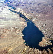
So much water is taken out of the Colorado River
Colorado River
The Colorado River , is a river in the Southwestern United States and northwestern Mexico, approximately long, draining a part of the arid regions on the western slope of the Rocky Mountains. The watershed of the Colorado River covers in parts of seven U.S. states and two Mexican states...
for agriculture, urban use, and evaporation behind the dams, that the river no longer flows into the Gulf of California
Gulf of California
The Gulf of California is a body of water that separates the Baja California Peninsula from the Mexican mainland...
.
While the need for clean, alternative energy
Alternative energy
Alternative energy is an umbrella term that refers to any source of usable energy intended to replace fuel sources without the undesired consequences of the replaced fuels....
sources are important, with so many considerations involved, sometimes it makes sense to evaluate whether the benefits of dams outweigh the costs of safety concerns, ecosystem functions, and management expenses.
Elwha Ecosystem Restoration Project
The largest dam removal project in history is the Elwha Ecosystem RestorationElwha Ecosystem Restoration
The Elwha Ecosystem Restoration Project in the United States is the largest dam removal project in history and the second largest ecosystem restoration project in the history of the National Park Service, after the Restoration of the Everglades...
project on the Olympic Peninsula
Olympic Peninsula
The Olympic Peninsula is the large arm of land in western Washington state of the USA, that lies across Puget Sound from Seattle. It is bounded on the west by the Pacific Ocean, the north by the Strait of Juan de Fuca, and the east by Puget Sound. Cape Alava, the westernmost point in the contiguous...
of Washington. In 2012, the 108 ft (32.9 m) Elwha Dam
Elwha Dam
The Elwha Dam is a 108-ft high dam located in the United States, in the state of Washington, on the Elwha River approximately upstream from the mouth of the river on the Strait of Juan de Fuca. The dam was built under the direction of Thomas Aldwell...
and the 210 ft (64 m) Glines Canyon Dam
Glines Canyon Dam
Glines Canyon Dam , built in 1927, is a high concrete arch dam that forms Lake Mills upstream from the Elwha River's mouth....
will be removed to restore anadromous stocks of Pacific Salmon and trout species to the Elwha River
Elwha River
The Elwha River is a -long river located on the Olympic Peninsula in the U.S. state of Washington. From its source at Elwha snowfinger in the Olympic Range of Olympic National Park it flows generally north to the Strait of Juan de Fuca. Most of the river is contained within Olympic National Park...
watershed. The removal of these blockades will allow migratory salmon to travel past the dams and upriver, an event that has not occurred since the dams' creation in 1913. Salmon reintroduction will allow for marine nutrients to return to the upper river beds as the salmon end their life cycles, providing a valuable research opportunity for interested parties.http://www.elwhascienceed.org/project-update/elwha-salmon-populations
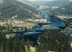
Savage Rapids Dam
The Savage Rapids DamSavage Rapids Dam
Savage Rapids Dam was an approximately , irrigation diversion dam spanning the mainstem of the Rogue River in Josephine County, Oregon. The dam was demolished and removed in 2009...
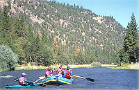
on the Rogue River
Rogue River (Oregon)
The Rogue River in southwestern Oregon in the United States flows about in a generally westward direction from the Cascade Range to the Pacific Ocean. Known for its salmon runs, whitewater rafting, and rugged scenery, it was one of the original eight rivers named in the Wild and Scenic Rivers Act...
in Oregon
Oregon
Oregon is a state in the Pacific Northwest region of the United States. It is located on the Pacific coast, with Washington to the north, California to the south, Nevada on the southeast and Idaho to the east. The Columbia and Snake rivers delineate much of Oregon's northern and eastern...
was built for agricultural water diversion. It was removed by the Bureau of Reclamation in 2009 due to its out-dated facilities and non-functioning fish ladders that prevent fish migration past the dam.
Marmot Dam Removal
The 50 ft (15.2 m) Marmot Dam on the Sandy RiverSandy River (Oregon)
The Sandy River is a tributary of the Columbia River in northwestern Oregon in the United States. Measured by a United States Geological Survey gauge downstream of the Sandy's confluence with the Bull Run River, from the mouth, the river's average discharge is . The maximum daily recorded flow...
in Oregon was removed in 2007 by Portland General Electric
Portland General Electric
Portland General Electric is an electrical utility based in Portland in the U.S. state of Oregon. It distributes electricity to customers in parts of Multnomah, Clackamas, Marion, Yamhill, Washington, and Polk counties - half of the inhabitants of Oregon...
. It has been an extremely successful project which has improved access for anadromous Pacific Salmon and Steelhead to access the upper Sandy River watershed up into the Mount Hood Wilderness
Mount Hood Wilderness
The Mount Hood Wilderness is a protected wilderness area inside the Mount Hood National Forest which is located in the U.S. state of Oregon. The area, covering , includes the peak of Mount Hood and its upper slopes, and ranges from temperate rain forests at the lower elevations, to glaciers and...
.
Lewiston Dam Removal
Idaho
Idaho is a state in the Rocky Mountain area of the United States. The state's largest city and capital is Boise. Residents are called "Idahoans". Idaho was admitted to the Union on July 3, 1890, as the 43rd state....
was removed in 1973. It was built in 1927 as a hydroelectric facility, but lacked fish ladders originally. Upon completion of the Lower Granite Dam and its reservoir, the lack of gradient on the river made it obsolete. Its removal improved salmon runs on the river.
Edwards Dam Removal
The 24 ft (7.3 m) Edwards DamEdwards Dam
Edwards Dam was a hydroelectric dam on the Kennebec River in the U.S. state of Maine. It was located in Augusta, Maine, about upstream from the Atlantic Ocean. Built in 1837 of timber and concrete, it was long and high...
on the Kennebec River
Kennebec River
The Kennebec River is a river that is entirely within the U.S. state of Maine. It rises in Moosehead Lake in west-central Maine. The East and West Outlets join at Indian Pond and the river then flows southward...
in Maine
Maine
Maine is a state in the New England region of the northeastern United States, bordered by the Atlantic Ocean to the east and south, New Hampshire to the west, and the Canadian provinces of Quebec to the northwest and New Brunswick to the northeast. Maine is both the northernmost and easternmost...
was removed in 1999. Built in 1837, it blocked access to anadromous Atlantic Salmon
Atlantic salmon
The Atlantic salmon is a species of fish in the family Salmonidae, which is found in the northern Atlantic Ocean and in rivers that flow into the north Atlantic and the north Pacific....
and American Shad
American shad
-Introduction:The American shad or Atlantic shad, Alosa sapidissima, is a species of anadromous fish in family Clupeidae of order Clupeiformes. It is not closely related to the other North American shads...
. Landmark case in which a federal agency required the decommissioning and removal of a dam against operator's wishes.
Marie Dorian Dam Removal
The 8 ft (2.4 m) Marie Dorian Dam on the Walla Walla RiverWalla Walla River
The Walla Walla River is a tributary of the Columbia River, joining the Columbia just above Wallula Gap in southeastern Washington in the United States. The river flows through Umatilla County, Oregon and Walla Walla County, Washington. Its drainage basin is in area.-Course:The headwaters of the...
in Oregon was removed in 1997. It blocked passage to anadromous Pacific Salmon and Steelhead into the Blue Mountains
Blue Mountains (Oregon)
The Blue Mountains are a mountain range in the western United States, located largely in northeastern Oregon and stretching into southeastern Washington...
from the Columbia Basin
Columbia Basin
The Columbia Basin, the drainage basin of the Columbia River, occupies a large area–about —of the Pacific Northwest region of North America. In common usage, the term often refers to a smaller area, generally the portion of the drainage basin that lies within eastern Washington.Usage of the term...
. money
White Salmon River Dams
The 123 ft (37.5 m) Condit Dam on the White Salmon RiverWhite Salmon River
The White Salmon River is a river flowing into the Columbia River Gorge, originating on the slopes of Mount Adams. The lower portion of the river is in the Columbia River Gorge National Scenic Area and some of the upper sections are part of the National Wild and Scenic Rivers system...
in Washington blocks access for anadromous Pacific Salmon and Steelhead runs on 33 miles (53.1 km) of river. PacifiCorp
PacifiCorp
PacifiCorp is an electric power company in the northwestern United States.PacifiCorp has three primary subsidiaries:# Pacific Power is a regulated electric utility with service territory throughout Oregon, northern California, and southeastern Washington.# Rocky Mountain Power is a regulated...
proposed to remove the dam, with the support of the environmental community. It was proposed for removal in 2006, but actions from Skamania and Klickitat counties have held up the process. In fall 2008, salmon will be trucked up above to dam to allow them to spawn higher up the river. In 2009, PacifiCorp will punch a 15 feet (4.6 m) hole in the dam to drain the reservoir and allow young salmon to enter the Columbia River
Columbia River
The Columbia River is the largest river in the Pacific Northwest region of North America. The river rises in the Rocky Mountains of British Columbia, Canada, flows northwest and then south into the U.S. state of Washington, then turns west to form most of the border between Washington and the state...
and head to sea.
Lower Snake River Dams
The lower four Snake RiverSnake River
The Snake is a major river of the greater Pacific Northwest in the United States. At long, it is the largest tributary of the Columbia River, the largest North American river that empties into the Pacific Ocean...
dams including the 100 ft (30.5 m) Lower Granite Dam, 98 ft (29.9 m) Little Goose Dam, 100 ft (30.5 m) Lower Monumental Dam, and 100 ft (30.5 m) Ice Harbor Dam. These dams, built by the United States Army Corps of Engineers
United States Army Corps of Engineers
The United States Army Corps of Engineers is a federal agency and a major Army command made up of some 38,000 civilian and military personnel, making it the world's largest public engineering, design and construction management agency...
, serve as hydroelectric power sources as well as ensuring agricultural barge traffic navigation to Lewiston, Idaho.
The lower four dams on the Snake River have collected large amounts of sediment. In fact, 3 million cubic yards of sediments are deposited each year.To combat this trend, cities like Lewiston, Idaho and many others along the Snake River have built a system of levees maintained by the Army Corps of Engineers. The levees in Lewiston were designed to leave five feet between water levels and the top of the levees. Today, there is only up to two feet remaining. As water levels continue to rise, either some of the dams must be removed or dredged, or the levees will continue to grow. The Corps admits that the amount of sediment in the riverbed is too great for dredging to be effective, and Lewiston community leaders are worried that higher levees will further cut the town off from its rivers.
Rindge Dam
The 100 ft (30.5 m) Rindge DamRindge Dam
The -tall Rindge Dam on Malibu Creek is located in Malibu Creek State Park, about three miles from the coast of Malibu, California. It is situated just northeast of Malibu Canyon Road, from which it is only partially visible...
on Malibu Creek
Malibu Creek
Malibu Creek is a year-round stream in western Los Angeles County, California. It drains the southern Simi Hills and the westernmost San Fernando Valley, flows south through the Santa Monica Mountains, and enters Santa Monica Bay east of Malibu. The Malibu Creek watershed drains and its tributary...
in the Santa Monica Mountains
Santa Monica Mountains
The Santa Monica Mountains are a Transverse Range in Southern California, along the coast of the Pacific Ocean in the United States.-Geography:...
of California was built in 1924 and today is completely filled with sediment, making it obsolete. Malibu Creek
Malibu Creek
Malibu Creek is a year-round stream in western Los Angeles County, California. It drains the southern Simi Hills and the westernmost San Fernando Valley, flows south through the Santa Monica Mountains, and enters Santa Monica Bay east of Malibu. The Malibu Creek watershed drains and its tributary...
once supported the southermost Steelhead population in the world. But, today the Steelhead no longer occupy the creek.
Klamath River Dams
Four dams on the Klamath RiverKlamath River
The Klamath River is an American river that flows southwest through Oregon and northern California, cutting through the Cascade Range to empty into the Pacific Ocean. The river drains an extensive watershed of almost that stretches from the high desert country of the Great Basin to the temperate...
including the J.C. Boyle, Copco No. 1, Copco No. 2, and Iron Gate dams. These dams are operated by PacifiCorp
PacifiCorp
PacifiCorp is an electric power company in the northwestern United States.PacifiCorp has three primary subsidiaries:# Pacific Power is a regulated electric utility with service territory throughout Oregon, northern California, and southeastern Washington.# Rocky Mountain Power is a regulated...
and are up for relicensing. In addition to blocking anadromous salmon runs, the reservoirs that form behind the dams built up extremely high levels of toxic algal blooms.
On September 29, 2009, a tentative agreement was reached to remove the four dams; if the plan proceeds they will be dismantled starting in 2020.
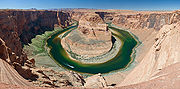
Glen Canyon Dam
The 710 ft (216.4 m) Glen Canyon DamGlen Canyon Dam
Glen Canyon Dam is a concrete arch dam on the Colorado River in northern Arizona in the United States, just north of Page. The dam was built to provide hydroelectricity and flow regulation from the upper Colorado River Basin to the lower. Its reservoir is called Lake Powell, and is the second...
has been proposed for removal because of the negative effects it has on the water quality and riparian habitat of the Colorado River
Colorado River
The Colorado River , is a river in the Southwestern United States and northwestern Mexico, approximately long, draining a part of the arid regions on the western slope of the Rocky Mountains. The watershed of the Colorado River covers in parts of seven U.S. states and two Mexican states...
in Grand Canyon National Park
Grand Canyon National Park
Grand Canyon National Park is the United States' 15th oldest national park and is located in Arizona. Within the park lies the Grand Canyon, a gorge of the Colorado River, considered to be one of the Wonders of the World. The park covers of unincorporated area in Coconino and Mohave counties.Most...
. In addition, the reservoir impounded behind it, Lake Powell
Lake Powell
Lake Powell is a huge reservoir on the Colorado River, straddling the border between Utah and Arizona . It is the second largest man-made reservoir in the United States behind Lake Mead, storing of water when full...
has filled all of the canyons for up to 100 miles (160.9 km) above the dam. This lake, while providing recreational opportunities, has eliminated more than 100 miles (160.9 km) of habitat for endangered Colorado River
Colorado River
The Colorado River , is a river in the Southwestern United States and northwestern Mexico, approximately long, draining a part of the arid regions on the western slope of the Rocky Mountains. The watershed of the Colorado River covers in parts of seven U.S. states and two Mexican states...
fish species. If it were to be removed, it would dwarf any dam removal project in history.
External links
- Elwha River Dam Removal Study
- Dam Removal Success Stories:Restoring Rivers through Selective Removal of Dams that Don't Make Sense
- Portland General Electric Marmot Dam
- Army Corps of Engineers Dam Removal Page
- Friends of the Earth River Restoration Page
- Natural Resources Council of Maine Kennebec River Restoration
- Spot.us - Story: The Story Behind the World's Biggest Dam Removal - Rough Water