

Salt River Project
Encyclopedia
The Salt River Project is the umbrella name for two separate entities: the Salt River Project Agricultural Improvement and Power District, an agency of the state of Arizona
that serves as an electrical utility for the Phoenix metropolitan area
, and the Salt River Valley Water Users' Association, a utility cooperative
that serves as the primary water provider for much of central Arizona. It is one of the primary public utility
companies in Arizona.
The name, Rio Salado Project, (Spanish for Salt River Project) is used to refer to the improvement projects along the Salt River
through the Phoenix Metropolitan Area
, is not related to SRP.
.
activities. The river was prone to both floods and drought
s and proved to be a less than reliable resource for the settlers. Failed plans to build a dam on the river in 1897, combined with a series of droughts, heightened the need for controlling the river.
With the passage of the National Reclamation Act of 1902, funding for reclamation projects with low-interest government loans paved the way for the creation of the Salt River Valley Water Users' Association the following year. Over 200,000 acres (800 km²) of private land belonging to the ranchers and farmers in the association were pledged for collateral and the association was officially incorporated February 7, 1903, becoming the first multipurpose project under the reclamation act. Construction on the Roosevelt Dam would commence the following year.
 Although the construction of dams was the association’s most visible and costly project, an integral part of the effort was also the construction and improvement of a system of canals designed to distribute the water from the Salt River among the various members living in the valley.
In 1909, a hydroelectric generator was installed at Roosevelt Dam; and, since that day, SRP has also been a major player in the power generation business.
In 1936, the Arizona Legislature allowed for the creation of governmental districts that could finance large-scale agricultural projects with tax-free bonds. Shortly thereafter, the Salt River Project Agricultural Improvement and Power District was created, the second half of SRP as it exists today. Over the next several decades, a series of major improvements along the Salt and Verde rivers would raise the number of reservoirs in the district to six, and at the same time SRP was constructing and maintaining a number of other electrical generating stations throughout the state.
As of 2007, SRP owns or operates eleven electrical generating stations, seven hydroelectric plants, and has energy purchasing agreements with four major hydroelectric stations along the Colorado River, making them a major provider of electric service in the Phoenix area. Along with the six reservoirs along the Salt and Verde rivers, SRP operates dams at the Blue Ridge Reservoir as well as the Granite Reef Diversion Dam and a number of canals, making the SRP a major provider of water to the Phoenix area.
and other watersports.
 Theodore Roosevelt Dam
and the Roosevelt Lake
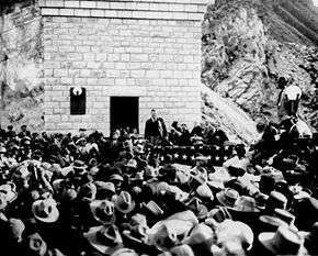
it forms are considered perhaps the crowning achievements of SRP. With the initial funds raised by the association in 1903, an ambitious project was begun several miles east of Phoenix in the Tonto Valley, at the confluence of the Tonto Creek and the Salt River. When it was completed in 1911, Roosevelt Dam was the tallest masonry dam in the world at 280 feet (85 m). It was dedicated by U.S. President Theodore Roosevelt
, for whom the dam and the reservoir are named.
In 1996, a massive expansion project aimed at increasing the capacity of the lake was finished. The dam was resurfaced with concrete and raised an additional 77 feet (23 m), which had the effect of increasing the lake’s capacity by over 20%, and providing much needed flood control space on the Salt River. Shortly after completion, however, the area entered into a prolonged period of drought, and it would be some time before the new capacity was used, with the lake finally reaching historic levels of 90% capacity in early 2005.
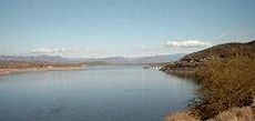
With an at-capacity surface area of nearly 21,500 acres (87 km²), Roosevelt is the largest lake that is wholly inside the state of Arizona. It can store 2910200 acre.ft of water at capacity.
 Apache Lake was formed by the construction of the Horse Mesa Dam
, finished in 1927. Several miles downstream from Roosevelt, the dam stands 300 feet (90 m) high. The lake itself is considerably smaller than Roosevelt at only 2,600 acres (11 km²) of surface area at full capacity, and can store 254138 acre.ft of water.
Like the rest of the Salt River lakes downstream from Roosevelt, Apache Lake is long and narrow, filling the bottom of the canyon it resides in. It does have a hydroelectric generating station.
, the third lake on the Salt River, is created by the Mormon Flat Dam
. The dam was completed in 1925, being the second of the dams to be completed. The dam is named for a nearby geographical feature, a flat campground where Mormon
pioneers from Utah
would often stop on their journey to the Phoenix area. Downstream from Apache Lake, it is considerably smaller with only 950 acres (3.8 km²) of surface area when full, holding 57852 acre.ft. Like the other Salt River dams, it is equipped with hydroelectric generators.

Saguaro Lake is formed by the Stewart Mountain Dam
, downstream from Canyon Lake. Completed in 1930, it was the last of the reservoirs to be built on the Salt River. It is somewhat larger than Canyon but smaller than the others, having a surface area of 1,280 acres (5.18 km²) when full, holding 69765 acre.ft. The dam is equipped with hydroelectric generators.
for further expansion of the project. Like the reservoirs on the Salt, the Verde reservoirs are used for recreational purposes as well as water storage and flood control.
is formed by Horseshoe Dam
and was finished in 1946, upstream from Lake Bartlett. Unlike the other dams built to this point, the construction was done by the Phelps Dodge Corporation
as part of a water exchange agreement. In 1949, the city of Phoenix funded the construction of spillway gates for the dam in exchange for water rights for city users. Like Bartlett, this dam does not have hydroelectric generating capabilities. At 2,800 acres (11 km²) in surface area when full it is slightly larger than Bartlett but has a smaller total capacity, holding only 131427 acre.ft at maximum.
, Blue Ridge is not on the Salt or Verde rivers but is a part of the general watershed covered in the SRP area. The small lake has a storage capacity of only 15000 acre.ft of water.
, constructed near the confluence of the Salt and Verde rivers, does not actually hold back a reservoir but is used to divert water from those rivers into the system of canals feeding into the Phoenix area. It was actually the first of the dams constructed, finished in 1906 to replace the Arizona Dam, which had been washed away by floods the previous year.
SRP also operates a number of flood control canals throughout the Phoenix area.
Arizona
Arizona ; is a state located in the southwestern region of the United States. It is also part of the western United States and the mountain west. The capital and largest city is Phoenix...
that serves as an electrical utility for the Phoenix metropolitan area
Phoenix Metropolitan Area
The Phoenix metropolitan area, often referred to as The Valley of the Sun, is a metropolitan area, centered on the city of Phoenix, that includes much of the central part of the US state of Arizona...
, and the Salt River Valley Water Users' Association, a utility cooperative
Utility cooperative
A utility cooperative is a type of cooperative that is tasked with the delivery of a public utility such as electricity, water or telecommunications to its members...
that serves as the primary water provider for much of central Arizona. It is one of the primary public utility
Public utility
A public utility is an organization that maintains the infrastructure for a public service . Public utilities are subject to forms of public control and regulation ranging from local community-based groups to state-wide government monopolies...
companies in Arizona.
The name, Rio Salado Project, (Spanish for Salt River Project) is used to refer to the improvement projects along the Salt River
Salt River (Arizona)
The Salt River is a stream in the U.S. state of Arizona. It is the largest tributary of the Gila River. The river is about long. Its drainage basin is about large. The longest of the Salt River's many tributaries is the Verde River...
through the Phoenix Metropolitan Area
Phoenix Metropolitan Area
The Phoenix metropolitan area, often referred to as The Valley of the Sun, is a metropolitan area, centered on the city of Phoenix, that includes much of the central part of the US state of Arizona...
, is not related to SRP.
Service territory
SRP serves nearly all of the Phoenix metropolitan area. A large chunk of its electric service territory is shared with Arizona Public ServiceArizona Public Service
Arizona Public Service Company is the largest electric utility in Arizona and the principal subsidiary of publicly-traded S&P 500 member Pinnacle West Capital Corporation , which in turn had been formerly named AZP Group, when Arizona Public Service reorganized as that holding company in 1985.With...
.
Governance
The Association is headed by a 10-member board and a 30-member council, while the District is headed by a 14-member board and a 30-member council. Both are elected by all landowners in the SRP service area through a "debt-proportionate" system. For instance, a person who owns five acres casts five votes.History
Early settlers in Phoenix and nearby areas were forced to depend upon the flow of the Salt River to sustain agriculturalAgriculture
Agriculture is the cultivation of animals, plants, fungi and other life forms for food, fiber, and other products used to sustain life. Agriculture was the key implement in the rise of sedentary human civilization, whereby farming of domesticated species created food surpluses that nurtured the...
activities. The river was prone to both floods and drought
Drought
A drought is an extended period of months or years when a region notes a deficiency in its water supply. Generally, this occurs when a region receives consistently below average precipitation. It can have a substantial impact on the ecosystem and agriculture of the affected region...
s and proved to be a less than reliable resource for the settlers. Failed plans to build a dam on the river in 1897, combined with a series of droughts, heightened the need for controlling the river.
With the passage of the National Reclamation Act of 1902, funding for reclamation projects with low-interest government loans paved the way for the creation of the Salt River Valley Water Users' Association the following year. Over 200,000 acres (800 km²) of private land belonging to the ranchers and farmers in the association were pledged for collateral and the association was officially incorporated February 7, 1903, becoming the first multipurpose project under the reclamation act. Construction on the Roosevelt Dam would commence the following year.
In 1909, a hydroelectric generator was installed at Roosevelt Dam; and, since that day, SRP has also been a major player in the power generation business.
In 1936, the Arizona Legislature allowed for the creation of governmental districts that could finance large-scale agricultural projects with tax-free bonds. Shortly thereafter, the Salt River Project Agricultural Improvement and Power District was created, the second half of SRP as it exists today. Over the next several decades, a series of major improvements along the Salt and Verde rivers would raise the number of reservoirs in the district to six, and at the same time SRP was constructing and maintaining a number of other electrical generating stations throughout the state.
As of 2007, SRP owns or operates eleven electrical generating stations, seven hydroelectric plants, and has energy purchasing agreements with four major hydroelectric stations along the Colorado River, making them a major provider of electric service in the Phoenix area. Along with the six reservoirs along the Salt and Verde rivers, SRP operates dams at the Blue Ridge Reservoir as well as the Granite Reef Diversion Dam and a number of canals, making the SRP a major provider of water to the Phoenix area.
Salt River reservoirs
SRP owns and operates four reservoirs along the Salt River east of Phoenix. While the main function of these reservoirs is to serve as water storage for the rapidly growing municipal area, they also serve as important recreational centers. The lakes are regularly stocked with fish, and are supplied with boat ramps for both anglingAngling
Angling is a method of fishing by means of an "angle" . The hook is usually attached to a fishing line and the line is often attached to a fishing rod. Fishing rods are usually fitted with a fishing reel that functions as a mechanism for storing, retrieving and paying out the line. The hook itself...
and other watersports.
Theodore Roosevelt Lake
Theodore Roosevelt Dam
Theodore Roosevelt Dam is a dam on the Salt River located northeast of Phoenix, Arizona. The dam is high and forms Theodore Roosevelt Lake as it impounds the Salt River. Originally built between 1905 and 1911, the dam was renovated and expanded in 1989-1996. The dam is named after then-President...
and the Roosevelt Lake
Theodore Roosevelt Lake
Theodore Roosevelt Lake is a large reservoir formed by Theodore Roosevelt Dam on the Salt River in Arizona as part of the Salt River Project...
it forms are considered perhaps the crowning achievements of SRP. With the initial funds raised by the association in 1903, an ambitious project was begun several miles east of Phoenix in the Tonto Valley, at the confluence of the Tonto Creek and the Salt River. When it was completed in 1911, Roosevelt Dam was the tallest masonry dam in the world at 280 feet (85 m). It was dedicated by U.S. President Theodore Roosevelt
Theodore Roosevelt
Theodore "Teddy" Roosevelt was the 26th President of the United States . He is noted for his exuberant personality, range of interests and achievements, and his leadership of the Progressive Movement, as well as his "cowboy" persona and robust masculinity...
, for whom the dam and the reservoir are named.
In 1996, a massive expansion project aimed at increasing the capacity of the lake was finished. The dam was resurfaced with concrete and raised an additional 77 feet (23 m), which had the effect of increasing the lake’s capacity by over 20%, and providing much needed flood control space on the Salt River. Shortly after completion, however, the area entered into a prolonged period of drought, and it would be some time before the new capacity was used, with the lake finally reaching historic levels of 90% capacity in early 2005.
With an at-capacity surface area of nearly 21,500 acres (87 km²), Roosevelt is the largest lake that is wholly inside the state of Arizona. It can store 2910200 acre.ft of water at capacity.
Apache Lake
Horse Mesa Dam
The Horse Mesa Dam is a concrete thin arch dam located Northeast of Phoenix, Arizona. The dam is long, high and was built between 1924-27. The dam includes three conventional hydroelectric generating units totaling 32 megawatts and a pumped-storage unit with a capacity of 97 MW. The dam forms...
, finished in 1927. Several miles downstream from Roosevelt, the dam stands 300 feet (90 m) high. The lake itself is considerably smaller than Roosevelt at only 2,600 acres (11 km²) of surface area at full capacity, and can store 254138 acre.ft of water.
Like the rest of the Salt River lakes downstream from Roosevelt, Apache Lake is long and narrow, filling the bottom of the canyon it resides in. It does have a hydroelectric generating station.
Canyon Lake
Canyon LakeCanyon Lake (Arizona)
Canyon Lake is one of four reservoirs that were formed by the damming of the Salt River in the U.S. state of Arizona.The lake was formed by the Mormon Flat Dam, which was completed in 1925 after two years of construction. Canyon Lake, with a surface area of , is the third and smallest of four lakes...
, the third lake on the Salt River, is created by the Mormon Flat Dam
Mormon Flat Dam
The Mormon Flat Dam is a dam on the Salt River located Northeast of Phoenix, Arizona. The dam is 380 feet long, 224 feet high and was built between 1923-25. The Dam is named after nearby Mormon Flat, a place where LDS settlers from Utah stopped to camp. There are two hydroelectric generating units...
. The dam was completed in 1925, being the second of the dams to be completed. The dam is named for a nearby geographical feature, a flat campground where Mormon
Mormon
The term Mormon most commonly denotes an adherent, practitioner, follower, or constituent of Mormonism, which is the largest branch of the Latter Day Saint movement in restorationist Christianity...
pioneers from Utah
Utah
Utah is a state in the Western United States. It was the 45th state to join the Union, on January 4, 1896. Approximately 80% of Utah's 2,763,885 people live along the Wasatch Front, centering on Salt Lake City. This leaves vast expanses of the state nearly uninhabited, making the population the...
would often stop on their journey to the Phoenix area. Downstream from Apache Lake, it is considerably smaller with only 950 acres (3.8 km²) of surface area when full, holding 57852 acre.ft. Like the other Salt River dams, it is equipped with hydroelectric generators.
Saguaro Lake
Saguaro Lake is formed by the Stewart Mountain Dam
Stewart Mountain Dam
The Stewart Mountain Dam is a concrete thin arch dam located 41 miles northeast of Phoenix, Arizona. The dam is long, high, and was built between 1928-30. The dam includes a 13,000 kilowatt hydroelectric generating unit that is operated by SRP , an Arizona public utility. It is primarily...
, downstream from Canyon Lake. Completed in 1930, it was the last of the reservoirs to be built on the Salt River. It is somewhat larger than Canyon but smaller than the others, having a surface area of 1,280 acres (5.18 km²) when full, holding 69765 acre.ft. The dam is equipped with hydroelectric generators.
Verde River reservoirs and other dams
After completion of the four dams on the Salt River, SRP turned to the smaller Verde RiverVerde River
The Verde River is the north and northwestern watershed of the Salt River–Verde River Watershed that co-join and enter the Gila River at Phoenix, Arizona, located in the U.S. state of Arizona...
for further expansion of the project. Like the reservoirs on the Salt, the Verde reservoirs are used for recreational purposes as well as water storage and flood control.
Bartlett Lake
The first of the lakes on the Verde River was created with the construction of the Bartlett Dam, finishing in 1939. At 308.5 feet (94 m) tall, the multiple-arch dam is lacking in hydroelectric generating capabilities, unlike most dams on the Salt River. Bartlett Lake, with 2,700 acres (11 km²) of surface area at capacity, is larger than all the Salt River reservoirs save Roosevelt. When full the lake can hold 178186 acre.ft of water.Horseshoe Lake
Horseshoe LakeHorseshoe Lake (Arizona)
Horseshoe Lake is a reservoir that was formed by the Horseshoe Dam on the Verde River in the U.S. state of Arizona. This lake is located inside the Tonto National Forest, as such the facilities located here are managed by that authority. Horseshoe Lake is the first of the Salt River Project lakes...
is formed by Horseshoe Dam
Horseshoe Dam (Arizona)
The Horseshoe Dam is a dam located North of Phoenix, Arizona. The dam is long, 144 feet high and was built between 1944-46. The dam forms the Horseshoe Lake as it slows the passage of the Verde River....
and was finished in 1946, upstream from Lake Bartlett. Unlike the other dams built to this point, the construction was done by the Phelps Dodge Corporation
Phelps Dodge
Phelps Dodge Corporation was an American mining company founded in 1834 by Anson Greene Phelps and William Earle Dodge, Sr.. On March 19, 2007, it was acquired by Freeport-McMoRan and now operates under the name Freeport-McMoRan Copper & Gold Inc.-History:...
as part of a water exchange agreement. In 1949, the city of Phoenix funded the construction of spillway gates for the dam in exchange for water rights for city users. Like Bartlett, this dam does not have hydroelectric generating capabilities. At 2,800 acres (11 km²) in surface area when full it is slightly larger than Bartlett but has a smaller total capacity, holding only 131427 acre.ft at maximum.
Blue Ridge Reservoir
Phelps Dodge, Inc., a large mining company in Arizona, constructed the Blue Ridge Dam in 1965 to help meet its water needs. A water exchange agreement penned three years earlier promised the facilities to SRP, and in 2005 SRP took possession of the dam and water production facilities. Located on the Mogollon RimMogollon Rim
The Mogollon Rim is a topographical and geological feature running across the U.S. state of Arizona. It extends approximately from northern Yavapai County eastward to near the border with New Mexico.-Description:...
, Blue Ridge is not on the Salt or Verde rivers but is a part of the general watershed covered in the SRP area. The small lake has a storage capacity of only 15000 acre.ft of water.
Granite Reef Dam
The Granite Reef Diversion DamGranite Reef Diversion Dam
The Granite Reef Diversion Dam is a concrete diversion dam located Northeast of Phoenix, Arizona, on the Salt River. The dam is long, high and was built between 1906-09 for the Salt River Project, who currently operates the dam....
, constructed near the confluence of the Salt and Verde rivers, does not actually hold back a reservoir but is used to divert water from those rivers into the system of canals feeding into the Phoenix area. It was actually the first of the dams constructed, finished in 1906 to replace the Arizona Dam, which had been washed away by floods the previous year.
Canal System
SRP operates several important canals that run in a network through much of the southern half of the Phoenix metropolitan area, helping distribute water from the Salt River system. Major canals operated by SRP are:- Arizona CanalArizona CanalThe Arizona Canal is a major canal in central Maricopa County that led to the founding of several communities, now among the wealthier neighborhoods of suburban Phoenix, in the late 1880s. Flood irrigation of residential yards is still common in these neighborhoods, using a system of lateral...
, 38.62 miles (62.15 km) long - Grand Canal, 22.43 miles (36.10 km)long
- Consolidated Canal, 18.95 miles (30.50 km) long
- Eastern Canal, 14.73 miles (23.71 km) long
- Western Canal, 13.61 miles (21.90 km) long
- South Canal, 9.91 miles (15.95 km) long
- Tempe Canal, 9.76 miles (15.71 km) long
- New Crosscut Canal, 3.4 miles (5.5 km) long
SRP also operates a number of flood control canals throughout the Phoenix area.
Power generation
Besides the power generated at several of the dams along the Salt River, SRP owns or operates, in part, several power generating stations throughout the state:- Agua Fria Generating Station
- Coronado Generating Station
- Craig Generating Station
- Desert Basin Generating Station
- Four Corners Generating StationFour Corners Generating StationThe Four Corners Generating Station is a coal-fired power plant located near Fruitland, New Mexico, United States, on property located within the Navajo Indian Reservation that is leased from the Navajo Nation.-Description:...
- Hayden Generating Station
- Kyrene Generating Station
- Mohave Generating Station
- Navajo Generating StationNavajo Generating StationNavajo Generating Station is a 2250 megawatt coal-fired powerplant located on the Navajo Indian Reservation, near Page, Arizona, USA. This plant provides electrical power to customers in Arizona, Nevada, and California...
- Palo Verde Nuclear Generating StationPalo Verde Nuclear Generating StationThe Palo Verde Nuclear Generating Station is a nuclear power plant located in Wintersburg, Arizona, about 45 miles west of central Phoenix. It is the largest nuclear generation facility in the United States, averaging over 3.3 gigawatts of electrical power production in 2008 to serve...
- Santan Generating Station
- Arizona Falls