

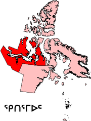
Kitikmeot Region, Nunavut
Encyclopedia
Region
Region is most commonly found as a term used in terrestrial and astrophysics sciences also an area, notably among the different sub-disciplines of geography, studied by regional geographers. Regions consist of subregions that contain clusters of like areas that are distinctive by their uniformity...
region of Nunavut
Nunavut
Nunavut is the largest and newest federal territory of Canada; it was separated officially from the Northwest Territories on April 1, 1999, via the Nunavut Act and the Nunavut Land Claims Agreement Act, though the actual boundaries had been established in 1993...
, Canada. It consists of the southern and eastern parts of Victoria Island with the adjacent part of the mainland as far as the Boothia Peninsula
Boothia Peninsula
Boothia Peninsula is a large peninsula in Nunavut's northern Canadian Arctic, south of Somerset Island. The northern part, Murchison Promontory, is the northernmost point of mainland Canada, and thus North America....
, together with King William Island
King William Island
King William Island is an island in the Kitikmeot Region of Nunavut and forms part of the Canadian Arctic Archipelago. In area it is between and making it the 61st largest island in the world and Canada's 15th largest island...
and the southern portion of Prince of Wales Island. The regional seat is Cambridge Bay
Cambridge Bay, Nunavut
Cambridge Bay, named for Prince Adolphus, Duke of Cambridge, is a hamlet located in the Kitikmeot Region of Nunavut, Canada...
(population 1,477).
Before 1999, Kitikmeot Region existed under slightly different boundaries as Kitikmeot Region, Northwest Territories
Kitikmeot Region, Northwest Territories
The Kitikmeot Region was part of the Northwest Territories until division in April 1999 when most of the region became part of Nunavut. It consisted of Victoria Island with the adjacent part of the mainland as far as the Boothia Peninsula, together with King William Island and the southern portion...
.
Transportation
Access to the territorial capital of Iqaluit is difficult and expensive as there are no direct flights from any community in the region. For example, Iqaluit is approximately 1069 km (664.2 mi) from KugaarukKugaaruk, Nunavut
-Culture:The historical inhabitants were Arviligjuarmiut. Kugaaruk is a traditional "Central Inuit" community. Until 1968, the people followed a nomadic lifestyle. The population is approximately 97% Inuit and most people self-identify as Netsilik Inuit. The residents blend a land based lifestyle...
, the closest Kitikmeot community. A one way flight to the capital costs about $2212 (as of October 2009) and involves flying to, along with an overnight stay in, Yellowknife, Northwest Territories
Northwest Territories
The Northwest Territories is a federal territory of Canada.Located in northern Canada, the territory borders Canada's two other territories, Yukon to the west and Nunavut to the east, and three provinces: British Columbia to the southwest, and Alberta and Saskatchewan to the south...
, approximately 1310 km (814 mi) southwest of Kugaaruk. In total a trip of about 3627 km (2,253.7 mi).
Politics
The region is home to the only two communities in Nunavut that voted "no" in the 1982 division plebiscite: Cambridge Bay and KugluktukKugluktuk, Nunavut
Kugluktuk is a hamlet located at the mouth of the Coppermine River in the Kitikmeot Region of Nunavut, Canada, on Coronation Gulf, southwest of Victoria Island...
(Coppermine).
The region has four electoral districts
Electoral district (Canada)
An electoral district in Canada, also known as a constituency or a riding, is a geographical constituency upon which Canada's representative democracy is based...
;
- AkulliqAkulliqAkulliq is a territorial electoral district for the Legislative Assembly of Nunavut, Canada.The riding consists of the communities of Kugaaruk and Repulse Bay.-1999 election:-2004 election:-2008 election:...
, which covers Kugaaruk and Repulse BayRepulse Bay, NunavutRepulse Bay is an Inuit hamlet located on the shore of Hudson Bay, Kivalliq Region, in Nunavut, Canada.-Location and wildlife:The hamlet is located exactly on the Arctic Circle, on the north shore of Repulse Bay and on the south shore of the Rae Isthmus. Transport to the community is provided...
in the Kivalliq Region. It is the ony electoral district in Nunavut to cross two regions. The seat is held by John NingarkJohn NingarkJohn Ningark is a territorial level politician in Canada. He is a former member of the Legislative Assembly of the Northwest Territories, and a current member of the Legislative Assembly of Nunavut.-Political history:...
. - Cambridge BayCambridge Bay (electoral district)Cambridge Bay is a territorial electoral district for the Legislative Assembly of Nunavut, Canada.The riding, which consists of the communities of Bathurst Inlet, Cambridge Bay and Umingmaktok, came into existence for the first Nunavut general election...
, which covers Bathurst InletBathurst Inlet, NunavutBathhurst Inlet, , is a small Inuit community located in Bathurst Inlet in the Kitikmeot Region of Canada's Nunavut Territory...
, Cambridge Bay and UmingmaktokUmingmaktok, NunavutThe community of Umingmaktok is located in Bathurst Inlet in the Kitikmeot Region of Canada's Nunavut Territory...
. The seat is held by Keith PetersonKeith PetersonAlan Keith Peterson was born in Whitehorse, Yukon, Canada and lives in Cambridge Bay, Nunavut. He is currently the Member of the Legislative Assembly for the electoral district of Cambridge Bay having won the seat in the 2004 Nunavut election....
. - KugluktukKugluktuk (electoral district)Kugluktuk is the most western territorial electoral district for the Legislative Assembly of Nunavut, Canada.The riding consists of the community of Kugluktuk in the Kitikmeot....
, which covers Kugluktuk. The seat is held by Peter TaptunaPeter TaptunaPeter Taptuna is a Canadian politician, who was elected as the Member of the Legislative Assembly for the electoral district of Kugluktuk in the Legislative Assembly of Nunavut in the 2008 territorial election... - NattilikNattilikNattilik is a territorial electoral district for the Legislative Assembly of Nunavut, Canada.The riding consists of the communities of Gjoa Haven and Taloyoak....
, which covers Gjoa HavenGjoa Haven, NunavutGjoa Haven is a hamlet in Nunavut, above the Arctic Circle, located in the Kitikmeot Region, northeast of Yellowknife, Northwest Territories. It is the only settlement on King William Island...
and TaloyoakTaloyoak, NunavutTaloyoak or Talurjuaq is located on the Boothia Peninsula, Kitikmeot, in Canada's Nunavut Territory. The community is served only by air and by annual supply sealift. Taloyoak may mean "large blind", referring to a stone caribou blind or a screen used for caribou hunting...
. The seat is held by Enuk PauloosieEnuk PauloosieEnuk Pauloosie was a Canadian politician, who was elected as the Member of the Legislative Assembly for the electoral district of Nattilik in the Legislative Assembly of Nunavut in the 2008 territorial election. His riding of Nattilik encompasses the communities of Gjoa Haven, Nunavut and Taloyoak,...
. The previous incumbent is the federalGovernment of CanadaThe Government of Canada, formally Her Majesty's Government, is the system whereby the federation of Canada is administered by a common authority; in Canadian English, the term can mean either the collective set of institutions or specifically the Queen-in-Council...
Minister of HealthMinister of Health (Canada)The Minister of Health is the Minister of the Crown in the Canadian Cabinet who is responsible for overseeing the federal government's health department and the enforcing the Public Health Agency of Canada, Canada Health Act, the law governing Medicare...
, Leona AglukkaqLeona AglukkaqLeona Aglukkaq, PC, MP is a Canadian politician, who was elected to the Canadian House of Commons as a Conservative in the 2008 Canadian federal election for the riding of Nunavut....
.
In 2007 at their AGM, Bob Lyall, a board member of the Kitikmeot Inuit Association, suggested the formation of a political party called the Bloc Kitikmeot to run in the next general election
Nunavut general election, 2008
The Third Nunavut General Election took place on October 27, 2008 to return members to the 3rd Legislative Assembly of Nunavut. The election was contested across 15 of Nunavut's 19 electoral districts under the first past the post system of voting...
and to advocate for a separate Kitikmeot Territory. Bobby Lyall, along with his brother Kitikmeot Corporation president, Charlie Lyall and delegates Martina and Connie Kapolak, argued that the Government of Nunavut had spent most of the infrastructure money available from the federal government in the Baffin Region (Qikiqtaaluk Region). However, the party was not formed and consequently no members ran for a seat in the Legislative Assembly of Nunavut
Legislative Assembly of Nunavut
The Legislative Assembly of Nunavut, Canada, is located in Iqaluit, and is the territory's parliament.The Legislative Assembly of Nunavut was opened by Queen Elizabeth II, as Queen of Canada, on 7 October 2002, during her Golden Jubilee tour of Canada...
which continues to run as a consensus government
Consensus government
Consensus government is a form of consensus democracy government in Canada in the Northwest Territories, Nunavut, as well as Nunatsiavut, an autonomous area in the province of Newfoundland and Labrador....
.
Communities
- Hamlets
-
- Cambridge BayCambridge Bay, NunavutCambridge Bay, named for Prince Adolphus, Duke of Cambridge, is a hamlet located in the Kitikmeot Region of Nunavut, Canada...
(Iqaluktuuttiaq) - Gjoa HavenGjoa Haven, NunavutGjoa Haven is a hamlet in Nunavut, above the Arctic Circle, located in the Kitikmeot Region, northeast of Yellowknife, Northwest Territories. It is the only settlement on King William Island...
- KugaarukKugaaruk, Nunavut-Culture:The historical inhabitants were Arviligjuarmiut. Kugaaruk is a traditional "Central Inuit" community. Until 1968, the people followed a nomadic lifestyle. The population is approximately 97% Inuit and most people self-identify as Netsilik Inuit. The residents blend a land based lifestyle...
(Pelly Bay) - KugluktukKugluktuk, NunavutKugluktuk is a hamlet located at the mouth of the Coppermine River in the Kitikmeot Region of Nunavut, Canada, on Coronation Gulf, southwest of Victoria Island...
(Coppermine) - TaloyoakTaloyoak, NunavutTaloyoak or Talurjuaq is located on the Boothia Peninsula, Kitikmeot, in Canada's Nunavut Territory. The community is served only by air and by annual supply sealift. Taloyoak may mean "large blind", referring to a stone caribou blind or a screen used for caribou hunting...
(Spence Bay)
- Cambridge Bay
- Other
-
- Bathurst InletBathurst Inlet, NunavutBathhurst Inlet, , is a small Inuit community located in Bathurst Inlet in the Kitikmeot Region of Canada's Nunavut Territory...
- UmingmaktuuqUmingmaktok, NunavutThe community of Umingmaktok is located in Bathurst Inlet in the Kitikmeot Region of Canada's Nunavut Territory...
(Bay Chimo) - Kitikmeot, UnorganizedKitikmeot, UnorganizedKitikmeot, Unorganized is part of the Kitikmeot census division in Nunavut, Canada. This area covers the entire Kitikmeot Region outside of the communities...
- Bathurst Inlet
Protected areas
- Ovayok Territorial Park
- North West Passage Territorial ParkNorth West Passage Territorial ParkThe Northwest Passage Territorial Park is located at Gjoa Haven, on King William Island, Kitikmeot Region, Nunavut, Canada. The park consists of six areas that show in part the history of the exploration of the Northwest Passage and the first successful passage by Roald Amundsen in the Gjøa.The...
- Kugluk/Bloody Falls Territorial ParkKugluk/Bloody Falls Territorial ParkKugluk/Bloody Falls Territorial Park is located about southwest of Kugluktuk, Nunavut, Canada. The park is situated around the Bloody Falls on the Coppermine River and was listed as a national historic site in 1978.The park is probably best known as the site of the Bloody Falls Massacre that...
- Queen Maud Gulf Bird SanctuaryQueen Maud Gulf Bird SanctuaryThe Queen Maud Gulf Migratory Bird Sanctuary is Canada's largest federally owned protected area, encompassing some of the Arctic Circle coastline. are marine, and are terrestrial....
Demographics
The Kitikmeot Region also doubles as one of three census divisions in Nunavut, the others being the Kivalliq (also known as the Keewatin) and the Qikiqtaaluk (also known as the Baffin) regions. Of the three the Kitikmeot is the second largest in size being 1618.33 km (1,005.6 mi) bigger than the Kivalliq. It has the smallest population and is the least densely populated of the three. The population is predominantly InuitInuit
The Inuit are a group of culturally similar indigenous peoples inhabiting the Arctic regions of Canada , Denmark , Russia and the United States . Inuit means “the people” in the Inuktitut language...
(88.3%) with 1.3% other aboriginal peoples
Aboriginal peoples in Canada
Aboriginal peoples in Canada comprise the First Nations, Inuit and Métis. The descriptors "Indian" and "Eskimo" have fallen into disuse in Canada and are commonly considered pejorative....
, 0.6% North American Indian
First Nations
First Nations is a term that collectively refers to various Aboriginal peoples in Canada who are neither Inuit nor Métis. There are currently over 630 recognised First Nations governments or bands spread across Canada, roughly half of which are in the provinces of Ontario and British Columbia. The...
and 0.7% Métis
Métis people (Canada)
The Métis are one of the Aboriginal peoples in Canada who trace their descent to mixed First Nations parentage. The term was historically a catch-all describing the offspring of any such union, but within generations the culture syncretised into what is today a distinct aboriginal group, with...
, and 10.3% non-Aboriginals.
Canada 2006 Census
Canada 2006 Census
The Canada 2006 Census was a detailed enumeration of the Canadian population. Census day was May 16, 2006. The next census following will be the 2011 Census. Canada's total population enumerated by the 2006 census was 31,612,897...
- Population: 5,361
- Population change (2001–2006): +11.3%
- Private dwellings: 1,540
- Area: 446727.7 km² (172,482.5 sq mi)
- Density: 0.012 PD/sqkm
- National rank in terms of population: 285th out of 288
- Territorial rank in terms of population: 3rd out of 3