
Caprivi Region
Encyclopedia
| Capital: | Katima Mulilo Katima Mulilo Katima Mulilo is the capital of the Caprivi Strip, Namibia's far north–east extension into central Southern Africa. It comprises two electoral constituencies, Katima Mulilo Rural and Katima Mulilo Urban... |
| Largest city: | Katima Mulilo Katima Mulilo Katima Mulilo is the capital of the Caprivi Strip, Namibia's far north–east extension into central Southern Africa. It comprises two electoral constituencies, Katima Mulilo Rural and Katima Mulilo Urban... |
| ISO 3166-2 ISO 3166-2:NA ISO 3166-2:NA is the entry for Namibia in ISO 3166-2, part of the ISO 3166 standard published by the International Organization for Standardization , which defines codes for the names of the principal subdivisions of all countries coded in ISO 3166-1.Currently for Namibia, ISO 3166-2 codes are... : |
NA-CA |
| Website: | www.arc.org.na |
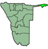
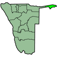
| Map: Caprivi in Namibia | |
|---|---|
 |
|
| Politics | |
| Governor Governor A governor is a governing official, usually the executive of a non-sovereign level of government, ranking under the head of state... : |
Leornard Mwilima (SWAPO) |
| Ruling party: | SWAPO |
| Representaion in regional government (6 seats): |
SWAPO |
| Last elections: | 2008 |
| Next elections: | 2012 |
| Population | |
| Population Population A population is all the organisms that both belong to the same group or species and live in the same geographical area. The area that is used to define a sexual population is such that inter-breeding is possible between any pair within the area and more probable than cross-breeding with individuals... : |
90 422 |
| Population density Population density Population density is a measurement of population per unit area or unit volume. It is frequently applied to living organisms, and particularly to humans... : |
4.62 persons/km² |
| Languages: | Silozi, Oshiwambo Oshiwambo language Ovambo, also known as Wambo or Ambo, or native Oshiwambo , is a dialect cluster in Angola and northern Namibia, of which the written standards are Kwanyama and Ndonga.... , English English language English is a West Germanic language that arose in the Anglo-Saxon kingdoms of England and spread into what was to become south-east Scotland under the influence of the Anglian medieval kingdom of Northumbria... , Afrikaans Afrikaans Afrikaans is a West Germanic language, spoken natively in South Africa and Namibia. It is a daughter language of Dutch, originating in its 17th century dialects, collectively referred to as Cape Dutch .Afrikaans is a daughter language of Dutch; see , , , , , .Afrikaans was historically called Cape... |
| Geography | |
| Area Area Area is a quantity that expresses the extent of a two-dimensional surface or shape in the plane. Area can be understood as the amount of material with a given thickness that would be necessary to fashion a model of the shape, or the amount of paint necessary to cover the surface with a single coat... : |
19,532 km² |
| of it forested: | approx 15,000 km² (70 %) |
| Rank: | 10th of 13 regions |
| Administrative divisions | |
| Constituencies: | 6 |
| Cities: | 1 |
Caprivi is one of the 13 regions of Namibia
Regions of Namibia
The administrative division of Namibia is tabled by Delimitation Commissions and accepted or declined by the National Assembly. The First Delimitation Commission chaired by Judge President Johan Strydom suggested in 1992 that Namibia be divided into 13 Regions, a number that has not been amended...
. It takes its name from the Caprivi Strip
Caprivi Strip
Caprivi, sometimes called the Caprivi Strip , Caprivi Panhandle or the Okavango Strip and formally known as Itenge, is a narrow protrusion of Namibia eastwards about , between Botswana to the south, Angola and Zambia to the north, and Okavango Region to the west. Caprivi is bordered by the...
which in turn was named after Leo von Caprivi
Leo von Caprivi
Georg Leo Graf von Caprivi de Caprera de Montecuccoli was a German major general and statesman, who succeeded Otto von Bismarck as Chancellor of Germany...
.
Geography
The Caprivi is a tropical area, with high temperatures and much rainfall during the December-to-March rainy season, making it the wettest region of Namibia. The terrainTerrain
Terrain, or land relief, is the vertical and horizontal dimension of land surface. When relief is described underwater, the term bathymetry is used...
is mostly made up of swamp
Swamp
A swamp is a wetland with some flooding of large areas of land by shallow bodies of water. A swamp generally has a large number of hammocks, or dry-land protrusions, covered by aquatic vegetation, or vegetation that tolerates periodical inundation. The two main types of swamp are "true" or swamp...
s, floodplain
Floodplain
A floodplain, or flood plain, is a flat or nearly flat land adjacent a stream or river that stretches from the banks of its channel to the base of the enclosing valley walls and experiences flooding during periods of high discharge...
s, wetland
Wetland
A wetland is an area of land whose soil is saturated with water either permanently or seasonally. Wetlands are categorised by their characteristic vegetation, which is adapted to these unique soil conditions....
s and woodland
Woodland
Ecologically, a woodland is a low-density forest forming open habitats with plenty of sunlight and limited shade. Woodlands may support an understory of shrubs and herbaceous plants including grasses. Woodland may form a transition to shrubland under drier conditions or during early stages of...
.
In addition to the Zambezi River, the strip also holds the Cuando and Kwando River, which marks the border with Botswana. Tributaries
Tributary
A tributary or affluent is a stream or river that flows into a main stem river or a lake. A tributary does not flow directly into a sea or ocean...
of the river here go by different names, including the Linyata and the Chobe. The province's far eastern is where the Cuando meets the Zambezi.
The region comprises six constituencies
Constituencies of Namibia
Each of the 13 regions in Namibia are further subdivided into electoral constituencies. The number and size of each constituency varies with the size and population of each region. There are currently 107 constituencies in Namibia...
: Kongola
Kongola Constituency
Kongola is a constituency in the Caprivi Region of Namibia near the Kwando River. It contains the district village of Kongola and the villages of Mwanzi, Izwi, Mulanga, Pipo, Munguza, Kahunikwa, Poca, Queensland, Kakuwa, Mitondo, Nxtohei, and Kachenje. Its population is 4,134.- References :...
, Linyanti
Linyanti Constituency
Linyanti is a constituency in the Caprivi Region of Namibia. Its population is 13,741. Linyanti is known for having a large marshland inside of it.- Politics :...
, Sibinda
Sibinda Constituency
Sibinda is a constituency in the Caprivi Region of Namibia. Its population is 9,164....
, Katima Mulilo Urban
Katima Mulilo Urban
Katima Mulilo Urban is a constituency in the Caprivi Region of Namibia, that also includes the capital city of Caprivi, Katima Mulilo. As of 2004, the Constituency had 10,778 registered voters.-Politics:...
, Katima Mulilo Rural
Katima Mulilo Rural
Katima Mulilo Rural is a constituency in the Caprivi Region of Namibia. Its population is 22,197. It is mostly the area surrounding the city of Katima Mulilo, the capital of Caprivi.-Politics:...
, and Kabbe.
Borders
Caprivi is almost entirely surrounded by foreign countries. Its only domestic border is a short connection in the west with OkavangoOkavango Region
Kavango is one of the thirteen regions of Namibia. Because of its rather higher rainfall than most other parts of Namibia, this region has definite agricultural potential for the cultivation of a variety of crops...
.
- In the northwest, it borders the Cuando CubangoCuando CubangoCuando Cubango is a province of Angola and it has an area of 199,049 km² and a population of approximately 140,000. Menongue is the capital of the province. The governor of the province is General Eusebio de Brito. According to 1988 US government statistics, the provincial population was...
Province of AngolaAngolaAngola, officially the Republic of Angola , is a country in south-central Africa bordered by Namibia on the south, the Democratic Republic of the Congo on the north, and Zambia on the east; its west coast is on the Atlantic Ocean with Luanda as its capital city...
. - In the north, it borders the WesternWestern Province, ZambiaWestern Province, encompasses the area formerly known as Barotseland in the colonial era.-Districts:Western Province is divided into 7 districts:*Kalabo District*Kaoma District*Lukulu District*Mongu District*Senanga District*Sesheke District...
Province of ZambiaZambiaZambia , officially the Republic of Zambia, is a landlocked country in Southern Africa. The neighbouring countries are the Democratic Republic of the Congo to the north, Tanzania to the north-east, Malawi to the east, Mozambique, Zimbabwe, Botswana and Namibia to the south, and Angola to the west....
. - In the south, it borders the North-WestNorth-West District (Botswana)North-West District Council is one of the local authorities of Botswana. It was established in 1966, overlapping the administrative districts of Chobe and Ngamiland...
District of BotswanaBotswanaBotswana, officially the Republic of Botswana , is a landlocked country located in Southern Africa. The citizens are referred to as "Batswana" . Formerly the British protectorate of Bechuanaland, Botswana adopted its new name after becoming independent within the Commonwealth on 30 September 1966...
.
The Namibia-Zambia-Botswana tripoint
Tripoint
A tripoint, or trijunction , is a geographical point at which the borders of three countries or subnational entities meet....
lies less than 100 meters from the Zimbabwe border and as such Namibia is sometimes erroneously thought to border Zimbabwe.
Flora and fauna
The region is home to 450 animal species, including elephants, making Caprivi a popular game-watching spot. The wildlifeWildlife
Wildlife includes all non-domesticated plants, animals and other organisms. Domesticating wild plant and animal species for human benefit has occurred many times all over the planet, and has a major impact on the environment, both positive and negative....
is protected by several nature reserve
Nature reserve
A nature reserve is a protected area of importance for wildlife, flora, fauna or features of geological or other special interest, which is reserved and managed for conservation and to provide special opportunities for study or research...
s, such as Bwabwata, Mudumu, Lizauli, West Caprivi Game Park, Mahango Game Reserve, and Mamili National Park
Mamili National Park
Mamili National Park is a national park in Namibia.Mamili is centered on the Nkasa and Lupala islands on the Kwando and Linyanti rivers in the south-western corner of East Caprivi...
; animals travel freely across the unmarked border with Botswana, where the Chobe National Park
Chobe National Park
Chobe National Park, in northwest Botswana, has one of the largest concentrations of game in Africa. By size, it is the third largest park of the country, after the Central Kalahari Game Reserve and the Gemsbok National Park, and is the most diverse...
lies. The strip is also a prime bird-watching area, with almost 70 percent of bird species found in Namibia being recorded here. Katima Mulilo
Katima Mulilo
Katima Mulilo is the capital of the Caprivi Strip, Namibia's far north–east extension into central Southern Africa. It comprises two electoral constituencies, Katima Mulilo Rural and Katima Mulilo Urban...
is the largest city, with other notable towns including Kongola
Kongola
Kongola is a village and the district capital of the Kongola Constituency in Namibia's Caprivi Strip. It is situated on the national road B8 . Kongola has a petrol station and a wholesaler. Although the village is situated on a national power line, it has not yet been connected to the electricity...
, Chinchimane, Bukalo
Bukalo
Bukalo is a settlement area in Namibia in the Caprivi region. It is situated about 40 km east of Katima Mulilo. It is where the Masubia Khuta is based under the control of Chief Liswani III. Currently, the Khuta is without a Ngambela, after Chrispin Katukula was ousted from his seat. Bukalo is...
, Sibinda
Sibinda
Sibinda is a village in northern Namibia. It is also the district capital of Sibinda Constituency in the Caprivi Region....
, and Impalila
Impalila
Impalila is an island at the far eastern tip of Namibia, bounded on the north by the waters of the Zambezi river and on the south by the Chobe River...
.
There are three game parks in the Caprivi region. The Caprivi Game Park is 5,715 square kilometers and extends for about 180 km from the Kavango
Kavango
The Kavango people, also known as the vaKavango, reside on the Namibian side of the Namibian–Angolan border along the Kavango River. They are mainly riverine living people, but about 20% reside in the dry inland. Their livelihood is based on fishery, livestock-keeping and cropping...
River in the west to the Kwando River in the east. Deciduous woodlands are dominated by trees such as wild seringa, copalwood and Zambezi teak. While the park is sanctuary to 35 large and numerous small game species, visitors are not likely to see many of these animals as vehicles are restricted to the road between Kavango and Eastern Caprivi. Animals likely to be seen are elephant, roan and kudu, buffalo occur towards the west. As many as 339 bird species have been recorded in west Caprivi.
The wild and little visited Mamili National Park
Mamili National Park
Mamili National Park is a national park in Namibia.Mamili is centered on the Nkasa and Lupala islands on the Kwando and Linyanti rivers in the south-western corner of East Caprivi...
is Namibia's equivalent of the Okavango Delta
Okavango Delta
The Okavango Delta , in Botswana, is the world's largest inland delta. It is formed where the Okavango River empties onto a swamp in an endorheic basin in the Kalahari Desert, where most of the water is lost to evaporation and transpiration instead of draining into the sea...
, a watery wonderland of wildlife rich islands, river channels and wetlands. The focal points of the 320km2 national park are Nkasa and Lupala, two large islands in the Kwando/Linyati river. During the dry season the islands can be reached by road but after the rains 80% of the area becomes flooded, cutting them off from the mainland.
Mudumu National Park
Mudumu National Park
The Mudumu National Park is a park in Namibia, created in 1990 out of 1009.59 square kilometers of savannah, mopane woodlands, and marsh on the eastern shore of the Cuando River. Many animals can be found in the park including sitatunga, red lechwe, as well as elephants, buffalo, kudu, impala,...
is a vast 100,959 hectare expanse of dense savannah and mopane woodland with the Kwando River at its western border. The park is home to small populations of sitatunga
Sitatunga
The situtunga or marshbuck is a swamp-dwelling antelope found throughout Central Africa, centering on the Democratic Republic of the Congo, Cameroon and parts of Southern Sudan as well as in Ghana, Botswana, Zambia, Gabon, Tanzania, Uganda and Kenya.-Description:Situtunga stand about one and a...
and red lechwe while spotted neck otter, hippo
Hippo
A hippo or hippopotamus is either of two species of large African mammal which live mainly in and near water:* Hippopotamus* Pygmy HippopotamusHippo may also refer to:-Given names:...
and crocodile
Crocodile
A crocodile is any species belonging to the family Crocodylidae . The term can also be used more loosely to include all extant members of the order Crocodilia: i.e...
inhabit the waterways. Animals to be encountered are elephant
Elephant
Elephants are large land mammals in two extant genera of the family Elephantidae: Elephas and Loxodonta, with the third genus Mammuthus extinct...
, buffalo, roan
Roan Antelope
The Roan Antelope is a savanna antelope found in West, Central, East Africa and Southern Africa.Roan Antelope stand about a metre and half at the shoulder and weigh around 250 kilograms. Named for the "roan' colour , they have a lighter underbelly, white eyebrows and cheeks and a black face,...
, sable
Sable
The sable is a species of marten which inhabits forest environments, primarily in Russia from the Ural Mountains throughout Siberia, in northern Mongolia and China and on Hokkaidō in Japan. Its range in the wild originally extended through European Russia to Poland and Scandinavia...
, kudu
Kudu
The kudus are two species of antelope of the genus Tragelaphus:*Lesser Kudu, Tragelaphus imberbis*Greater Kudu, Tragelaphus strepsiceros- Etymology :...
, impala
Impala
An impala is a medium-sized African antelope. The name impala comes from the Zulu language meaning "gazelle"...
, oribi
Oribi
Oribi are graceful slender-legged, long-necked small antelope found in grassland almost throughout Sub-Saharan Africa.-Description:...
, zebra
Zebra
Zebras are several species of African equids united by their distinctive black and white stripes. Their stripes come in different patterns unique to each individual. They are generally social animals that live in small harems to large herds...
, wild dog
Wild dog
Wild dog is a term broadly applied to canines which are either not domesticated or not owned. It may also refer to:* Feral dogs, domestic dogs living as wild animals....
as well as some 430 species of birds.
History
Until the end of the 19th century, it was known as Itenge and it was under the rule of the LoziLozi people
The Lozi people are an ethnic group primarily of western Zambia, inhabiting the region of Barotseland. Lozi are also found in Namibia , Angola and Botswana.-Name:...
kings. In the late 19th century the strip of land was administered as part of the British
United Kingdom
The United Kingdom of Great Britain and Northern IrelandIn the United Kingdom and Dependencies, other languages have been officially recognised as legitimate autochthonous languages under the European Charter for Regional or Minority Languages...
protectorate
Protectorate
In history, the term protectorate has two different meanings. In its earliest inception, which has been adopted by modern international law, it is an autonomous territory that is protected diplomatically or militarily against third parties by a stronger state or entity...
of Bechuanaland (Botswana). The German Empire
German Empire
The German Empire refers to Germany during the "Second Reich" period from the unification of Germany and proclamation of Wilhelm I as German Emperor on 18 January 1871, to 1918, when it became a federal republic after defeat in World War I and the abdication of the Emperor, Wilhelm II.The German...
in 1890 laid claim to the British-administered island of Zanzibar
Zanzibar
Zanzibar ,Persian: زنگبار, from suffix bār: "coast" and Zangi: "bruin" ; is a semi-autonomous part of Tanzania, in East Africa. It comprises the Zanzibar Archipelago in the Indian Ocean, off the coast of the mainland, and consists of numerous small islands and two large ones: Unguja , and Pemba...
; Britain objected and the dispute was settled at the Berlin Conference
Berlin Conference
The Berlin Conference of 1884–85 regulated European colonization and trade in Africa during the New Imperialism period, and coincided with Germany's sudden emergence as an imperial power...
later that year. On July 1, 1890, the British acquired Zanzibar and Germany acquired the territory which became known as the Caprivi Strip. Caprivi was named after German Chancellor Leo von Caprivi
Leo von Caprivi
Georg Leo Graf von Caprivi de Caprera de Montecuccoli was a German major general and statesman, who succeeded Otto von Bismarck as Chancellor of Germany...
, who negotiated the land in an 1890 exchange with the United Kingdom
United Kingdom
The United Kingdom of Great Britain and Northern IrelandIn the United Kingdom and Dependencies, other languages have been officially recognised as legitimate autochthonous languages under the European Charter for Regional or Minority Languages...
. Leo von Caprivi arranged for Caprivi to be annexed to German South-West Africa
German South-West Africa
German South West Africa was a colony of Germany from 1884 until 1915, when it was taken over by South Africa and administered as South West Africa, finally becoming Namibia in 1990...
in order to give Germany
Germany
Germany , officially the Federal Republic of Germany , is a federal parliamentary republic in Europe. The country consists of 16 states while the capital and largest city is Berlin. Germany covers an area of 357,021 km2 and has a largely temperate seasonal climate...
access to the Zambezi River
Zambezi
The Zambezi is the fourth-longest river in Africa, and the largest flowing into the Indian Ocean from Africa. The area of its basin is , slightly less than half that of the Nile...
as part of the Heligoland-Zanzibar Treaty
Heligoland-Zanzibar Treaty
The Heligoland-Zanzibar Treaty of 1 July 1890 was an agreement between the United Kingdom and the German Empire concerning mainly territorial interests in Africa.-Terms:...
. The German motivation behind the swap was to acquire a strip of land linking German South-West Africa
German South-West Africa
German South West Africa was a colony of Germany from 1884 until 1915, when it was taken over by South Africa and administered as South West Africa, finally becoming Namibia in 1990...
with the Zambezi River, providing easy access to Tanganyika
Tanganyika
Tanganyika , later formally the Republic of Tanganyika, was a sovereign state in East Africa from 1961 to 1964. It was situated between the Indian Ocean and the African Great Lakes of Lake Victoria, Lake Malawi and Lake Tanganyika...
(Tanzania) and an outlet to the Indian Ocean
Indian Ocean
The Indian Ocean is the third largest of the world's oceanic divisions, covering approximately 20% of the water on the Earth's surface. It is bounded on the north by the Indian Subcontinent and Arabian Peninsula ; on the west by eastern Africa; on the east by Indochina, the Sunda Islands, and...
. Unfortunately for the Germans, the British colonisation of Rhodesia
Rhodesia
Rhodesia , officially the Republic of Rhodesia from 1970, was an unrecognised state located in southern Africa that existed between 1965 and 1979 following its Unilateral Declaration of Independence from the United Kingdom on 11 November 1965...
(Zimbabwe
Zimbabwe
Zimbabwe is a landlocked country located in the southern part of the African continent, between the Zambezi and Limpopo rivers. It is bordered by South Africa to the south, Botswana to the southwest, Zambia and a tip of Namibia to the northwest and Mozambique to the east. Zimbabwe has three...
and Zambia
Zambia
Zambia , officially the Republic of Zambia, is a landlocked country in Southern Africa. The neighbouring countries are the Democratic Republic of the Congo to the north, Tanzania to the north-east, Malawi to the east, Mozambique, Zimbabwe, Botswana and Namibia to the south, and Angola to the west....
) stopped them well upstream of Victoria Falls
Victoria Falls
The Victoria Falls or Mosi-oa-Tunya is a waterfall located in southern Africa on the Zambezi River between the countries of Zambia and Zimbabwe.-Introduction:...
, which proved a considerable barrier to navigation on the Zambezi.
During World War I
World War I
World War I , which was predominantly called the World War or the Great War from its occurrence until 1939, and the First World War or World War I thereafter, was a major war centred in Europe that began on 28 July 1914 and lasted until 11 November 1918...
, the Caprivi Strip again came under British rule and was governed as part of Bechuanaland but it received little attention and became known as a lawless frontier. Today approximately 66,000 people live in the Caprivi, mostly as subsistence farmers who make their living on the banks of the Zambezi, Kwando, Linyati and Chobe
Cuando River
The Cuando River is a river in south-central Africa flowing through Angola and Namibia's Caprivi Strip, into the Linyanti Swamp on the northern border of Botswana...
Rivers.
The strip became of geopolitical importance during the 1980s when it was used as a jumping off point and re-supply route for South African support for the UNITA
UNITA
The National Union for the Total Independence of Angola is the second-largest political party in Angola. Founded in 1966, UNITA fought with the Popular Movement for the Liberation of Angola in the Angolan War for Independence and then against the MPLA in the ensuing civil war .The war was one...
movement in Angola
Angola
Angola, officially the Republic of Angola , is a country in south-central Africa bordered by Namibia on the south, the Democratic Republic of the Congo on the north, and Zambia on the east; its west coast is on the Atlantic Ocean with Luanda as its capital city...
.
Ethnography
About 80,000 people live in Caprivi, about four percent of Namibia's population. About 17,000 are part of the LoziLozi people
The Lozi people are an ethnic group primarily of western Zambia, inhabiting the region of Barotseland. Lozi are also found in Namibia , Angola and Botswana.-Name:...
ethnic group of 556,000 people, who also live in western Zambia, northwest Zimbabwe (70,000), and northern Botswana (14,000). According to the Ethnologue, the Lozi language
Lozi language
Lozi, also known as siLozi and Rozi, is a Bantu language of the Niger–Congo language family within the Sotho languages branch of Zone S , that is spoken by the Lozi people, primarily in southwestern Zambia and in surrounding countries...
is "spoken as lingua franca by all East Caprivians."
There has been ethnic tension between the Lozis and the Ovambos, the majority ethnic group of northern Namibia. This has led to past conflict, including the 1994 formation of the Caprivi Liberation Front, which pushes for Caprivi-Lozi self-rule.