
Ohangwena Region
Encyclopedia
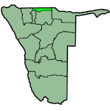
Ohangwena is one of the thirteen regions of Namibia
. The northern and western parts of the region are the most densely populated of this essentially subsistence agricultural region in which small scale mahangu cultivation and the keeping of cattle form the predominant activities. Although the region depends on rain fed agriculture, other crops can be established under intensive cultivation.
The main settlements in the region straddle the good paved road from the Angola
n border to Ondangua
, where it joins the Oshakati-Tsumeb trunk road. The eastern part of the region possesses good grazing land, but the shortage of water and poor communications render it uninhabitable at present. There is a reasonable gravel road from Oshikango to Okongo, and if a road connection linking the region to Rundu were to be built, it would greatly increase the agricultural potential of the area.
In the north, Ohangwena borders Angola: the Cunene
Province, except for a small border with Cuando Cubango
Province in the far northeast. Domestically, it borders the following regions:
It is traversed by the northwesterly line of equal latitude and longitude.
The region comprises ten constituencies
: Ongenga
, Engela
, Oshikango
, Ondobe
, Eenhana
, Omundaungilo
, Okongo
, Ohangwena
, Endola
, and Epembe
.
The most commonly spoken languages at home were Oshiwambo languages, spoken in 97% of households. For those 15 years and older, the literacy rate was 79%. In terms of education, 53% of girls and 47% of boys between the ages of 6-15 were attending school, and of those 15 years and older, 51% had left school, 23% were currently at school, and 23% had never attended.
The employment rate for the labor force (43% of those 15+) was 64% employed and 36% unemployed. For those 15+ years old and not in the labor force (53%), 35% were students, 41% homemakers, and 24% retired, too old, etc.
Among households, 78% had safe water, 89% no toilet facility, 4% electricity for lighting, 72% access to radio
, and 94% had wood or charcoal for cooking. In terms of households' main sources of income, 52% derived it from farming, 13% from wages and salaries, 5% cash remittances, 8% from business or non-farming, and 20% from pension.
For every 1000 live births there were 56 female infant deaths and 56 male. The life expectancy at birth was 45 years for females and 43 for males. Among children younger than 15, 5% had lost a mother, 11% a father, and 2% were orphaned by both parents. 5% of the entire population had a disability, of which 22% were deaf, 32% blind, 11% had a speech disability, 15% hand disability, 26% leg disability, and 5% mental disability.
, Deputy Minister Pohamba Shifeta
and others.
A significant amount of fighting occurred in the region during the Namibian War of Independence
. Just as Namibia was set for independence, fighting broke out on April 1, 1989 in the region between People's Liberation Army of Namibia
combatants and soldiers in the occupying South African Defence Forces
. The resulting "9 day war" left many dead.
Regions of Namibia
The administrative division of Namibia is tabled by Delimitation Commissions and accepted or declined by the National Assembly. The First Delimitation Commission chaired by Judge President Johan Strydom suggested in 1992 that Namibia be divided into 13 Regions, a number that has not been amended...
. The northern and western parts of the region are the most densely populated of this essentially subsistence agricultural region in which small scale mahangu cultivation and the keeping of cattle form the predominant activities. Although the region depends on rain fed agriculture, other crops can be established under intensive cultivation.
The main settlements in the region straddle the good paved road from the Angola
Angola
Angola, officially the Republic of Angola , is a country in south-central Africa bordered by Namibia on the south, the Democratic Republic of the Congo on the north, and Zambia on the east; its west coast is on the Atlantic Ocean with Luanda as its capital city...
n border to Ondangua
Ondangua
Ondangwa , is a town of 11,000 inhabitants in the Oshana Region of northern Namibia, bordering Oshikoto Region. Ondangwa means the end of the Ondonga area . Located about from the Angolan border, Ondangwa is situated along the B1. It is one of the places of residence of the Kings of Ondonga...
, where it joins the Oshakati-Tsumeb trunk road. The eastern part of the region possesses good grazing land, but the shortage of water and poor communications render it uninhabitable at present. There is a reasonable gravel road from Oshikango to Okongo, and if a road connection linking the region to Rundu were to be built, it would greatly increase the agricultural potential of the area.
In the north, Ohangwena borders Angola: the Cunene
Cunene (province)
Cunene is a province of Angola. It has an area of 87,342 km² and a population of approximately 200,000 to 300,000.-Overview:Ondjiva is the capital of the province it was previously known as Vila Pereira d’Eça . Ondjiva is the only city in this province...
Province, except for a small border with Cuando Cubango
Cuando Cubango
Cuando Cubango is a province of Angola and it has an area of 199,049 km² and a population of approximately 140,000. Menongue is the capital of the province. The governor of the province is General Eusebio de Brito. According to 1988 US government statistics, the provincial population was...
Province in the far northeast. Domestically, it borders the following regions:
- OkavangoOkavango RegionKavango is one of the thirteen regions of Namibia. Because of its rather higher rainfall than most other parts of Namibia, this region has definite agricultural potential for the cultivation of a variety of crops...
- east - OshikotoOshikoto RegionOshikoto is one of the thirteen regions of Namibia. The northern part of the region is agricultural, whereas the main economic activities in the southern part are cattle rearing and mining...
- south - OshanaOshanaOshana is one of the thirteen regions of Namibia. The name Oshana lends itself well to this region as it describes the most prominent landscape feature in the area, namely the shallow, seasonally inundated depressions which underpin the local agro ecological system...
- southwest - OmusatiOmusatiOmusati region is one of the thirteen regions of Namibia. Uutapi at Ombalantu forms a natural centre for this region. Mopani tree is the dominant species; the Makalani palms decrease rapidly westwards from the border with Oshana region...
- west
It is traversed by the northwesterly line of equal latitude and longitude.
The region comprises ten constituencies
Constituencies of Namibia
Each of the 13 regions in Namibia are further subdivided into electoral constituencies. The number and size of each constituency varies with the size and population of each region. There are currently 107 constituencies in Namibia...
: Ongenga
Ongenga Constituency
Ongenga is a constituency in the Ohangwena Region of Namibia, on the border to Angola. It has 21,474 inhabitants, the district centre is the settlement of Ongenga.- References :...
, Engela
Engela Constituency
Engela is a constituency in the Ohangwena Region of Namibia. It has 21,341 inhabitants.- References :...
, Oshikango
Oshikango Constituency
Oshikango is a constituency in the Ohangwena Region of Namibia, on the border to Angola. It has 27,599 inhabitants, the district centre is the village of Oshikango....
, Ondobe
Ondobe Constituency
Ondobe is a constituency in the Ohangwena Region of Namibia. It has 32,726 inhabitants, the district centre is the settlement of Ondobe.Ondobe Constituency contains the village of Okanghudi, the birthplace of Hifikepunye Pohamba, the President of Namibia....
, Eenhana
Eenhana Constituency
Eenhana is a constituency in the Ohangwena Region of Namibia, on the border to Angola. It has 24,193 inhabitants, the district centre is the town of Eenhana.- References :...
, Omundaungilo
Omundaungilo Constituency
Omundaungilo is a constituency in the Ohangwena Region of Namibia, on the border to Angola. It has 8,085 inhabitants.- References :...
, Okongo
Okongo Constituency
Okongo is a constituency in the Ohangwena Region of Namibia, on the border to Angola. It has 21,321 inhabitants. The main settlement and district capital is Okongo.- References :...
, Ohangwena
Ohangwena Constituency
Ohangwena is a constituency in the Ohangwena Region of Namibia, on the border to Angola. It has 17,539 inhabitants, the district centre is the town of Ohangwena.- References :...
, Endola
Endola Constituency
Endola is a constituency in the Ohangwena Region of Namibia, on the border to Angola. It has 36,659 inhabitants, the district centre is the settlement of Endola.- References :...
, and Epembe
Epembe Constituency
Epembe is a constituency in the Ohangwena Region of Namibia, on the border to Angola. It has 14,837 inhabitants, the district centre is the settlement of Epembe.- References :...
.
Demographics
According to the Namibia 2001 Population and Housing Census, Ohangwena had a population of 228,384 (124,823 females and 103,556 males or 83 males for every 100 females) growing at an annual rate of 2.4%. The fertility rate was 5.3 children per woman. 1% lived in urban areas while 99% lived in rural areas, and with an area of 10,703km2, the population density was 21.3 persons per km2. By age, 15% of the population was under 5 years old, 33% between 5-14 years, 41% between 15-59 years, and 9% 60 years and older. The population was divided into 35,958 households, with an average size of 6.3 persons. 60% of households had a female head of house, while 40% had a male. For those 15 years and older, 59% had never married, 17% married with certificate, 9% married traditionally, 4% married concensually, 4% were divorced or separated, and 6% were widowed.The most commonly spoken languages at home were Oshiwambo languages, spoken in 97% of households. For those 15 years and older, the literacy rate was 79%. In terms of education, 53% of girls and 47% of boys between the ages of 6-15 were attending school, and of those 15 years and older, 51% had left school, 23% were currently at school, and 23% had never attended.
The employment rate for the labor force (43% of those 15+) was 64% employed and 36% unemployed. For those 15+ years old and not in the labor force (53%), 35% were students, 41% homemakers, and 24% retired, too old, etc.
Among households, 78% had safe water, 89% no toilet facility, 4% electricity for lighting, 72% access to radio
Radio
Radio is the transmission of signals through free space by modulation of electromagnetic waves with frequencies below those of visible light. Electromagnetic radiation travels by means of oscillating electromagnetic fields that pass through the air and the vacuum of space...
, and 94% had wood or charcoal for cooking. In terms of households' main sources of income, 52% derived it from farming, 13% from wages and salaries, 5% cash remittances, 8% from business or non-farming, and 20% from pension.
For every 1000 live births there were 56 female infant deaths and 56 male. The life expectancy at birth was 45 years for females and 43 for males. Among children younger than 15, 5% had lost a mother, 11% a father, and 2% were orphaned by both parents. 5% of the entire population had a disability, of which 22% were deaf, 32% blind, 11% had a speech disability, 15% hand disability, 26% leg disability, and 5% mental disability.
Politics in Ohangwena region
Ohangwena region is one of the regions where many of the politicians are from, including President Hifikepunye PohambaHifikepunye Pohamba
Hifikepunye Lucas Pohamba is the second and current President of Namibia. He won the 2004 and 2009 presidential elections overwhelmingly as the candidate of the South West Africa People's Organisation ruling party, taking office in March 2005. He has also been the President of SWAPO since...
, Deputy Minister Pohamba Shifeta
Pohamba Shifeta
Pohamba Shifeta is a Namibian politician. A member of the National Assembly of Namibia since 2005, Shifeta is a member of SWAPO. At the time of his election to the National Assembly, Shifeta was chosen as the Deputy Secretary of Youth, National Service, Sport and Culture...
and others.
A significant amount of fighting occurred in the region during the Namibian War of Independence
Namibian War of Independence
See also South African Border War.The Namibian War of Independence, also known as the South African Border War, which lasted from 1966 to 1988, was a guerrilla war, which the nationalist South-West Africa People's Organization and others, fought against the apartheid government in South...
. Just as Namibia was set for independence, fighting broke out on April 1, 1989 in the region between People's Liberation Army of Namibia
People's Liberation Army of Namibia
The People's Liberation Army of Namibia was the active military wing of the South West Africa People's Organization during the Namibian War of Independence. It sought independence for the territory from South African rule. PLAN launched its first attack on the South African military at...
combatants and soldiers in the occupying South African Defence Forces
South African Defence Force
The South African Defence Force was the South African armed forces from 1957 until 1994. The former Union Defence Force was renamed to the South African Defence Force in the Defence Act of 1957...
. The resulting "9 day war" left many dead.