
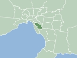
City of Glen Eira
Encyclopedia
Melbourne
Melbourne is the capital and most populous city in the state of Victoria, and the second most populous city in Australia. The Melbourne City Centre is the hub of the greater metropolitan area and the Census statistical division—of which "Melbourne" is the common name. As of June 2009, the greater...
. It has an area of 38.4 square kilometres and has a estimated population of 136,354 people. It was formed in 1994 from the merger of the City of Caulfield
City of Caulfield
The City of Caulfield was a Local Government Area located about southeast of Melbourne, the state capital of Victoria, Australia. The city covered an area of , and existed from 1857 until 1994.-History:...
and parts of the City of Moorabbin
City of Moorabbin
The City of Moorabbin was a Local Government Area located about southeast of Melbourne, the state capital of Victoria, Australia. The city covered an area of , and existed from 1862 until 1994.-History:...
.
Demographics
The City has a diverse population, and includes the large Jewish community in Elsternwick, St Kilda East and Caulfield - at the 2001 census, 16.6% professed Judaism as their religious affiliation, second only to Catholicism (22.2%). Significant Greek, Italian, Polish, Chinese and Russian communities also make their home in the city. Residents' median age and income in the census were both slightly higher than average for the Melbourne statistical division.Suburbs
Suburbs which lay within Glen Eira include:- BentleighBentleigh, VictoriaBentleigh is a suburb in Melbourne, Victoria, Australia, 13 km south-east from Melbourne's central business district. Its Local Government Area is the City of Glen Eira. At the 2006 Census, Bentleigh had a population of 14,271.-History:...
- Bentleigh EastBentleigh East, VictoriaBentleigh East is a suburb in Melbourne, Victoria, Australia, 14 km south-east from Melbourne's central business district. Its Local Government Area is the City of Glen Eira. At the 2006 Census, Bentleigh East had a population of 24,520....
- Brighton EastBrighton East, VictoriaBrighton East is a suburb in Melbourne, Victoria, Australia, 11 km south-east from Melbourne's central business district. Its Local Government Area is the City of Bayside. At the 2006 Census, Brighton East had a population of 15,167....
, overlaps City of BaysideCity of BaysideThe City of Bayside is a Local Government Area in Victoria, Australia. It is located in the southern suburbs of Melbourne. It has an area of 36 square kilometres and has a estimated population of 96,329 people.-City of Brighton:... - CaulfieldCaulfield, VictoriaCaulfield is a suburb in Melbourne, Victoria, Australia, 12 km south-east from Melbourne's central business district. Its Local Government Area is the City of Glen Eira...
- Caulfield EastCaulfield East, VictoriaCaulfield East is a suburb in Melbourne, Victoria, Australia, 10 km south-east from Melbourne's central business district. Its Local Government Area is the City of Glen Eira. At the 2006 Census, Caulfield East had a population of 1242....
- Caulfield NorthCaulfield North, VictoriaCaulfield North is a suburb in Melbourne, Victoria, Australia, 9 km south-east from Melbourne's central business district. Its Local Government Area is the City of Glen Eira. At the 2006 Census, Caulfield North had a population of 14,034....
- Caulfield SouthCaulfield South, VictoriaCaulfield South is a suburb in Melbourne, Victoria, Australia, 10 km south-east from Melbourne's central business district. Its Local Government Area is the City of Glen Eira. At the 2006 Census, Caulfield South had a population of 11,113....
- CarnegieCarnegie, VictoriaCarnegie is a suburb in Melbourne, Victoria, Australia, 12 km south-east from Melbourne's central business district. Its Local Government Area is the City of Glen Eira. At the 2006 Census, Carnegie had a population of 15,084...
- ElsternwickElsternwick, VictoriaElsternwick is a suburb in Melbourne, Victoria, Australia, 9 km south-east from Melbourne's central business district. Its Local Government Area is the City of Glen Eira...
- GardenvaleGardenvale, VictoriaGardenvale is a suburb in Melbourne, Victoria, Australia, 10 km south-east from Melbourne's central business district. Its Local Government Area is the City of Glen Eira...
- Glen HuntlyGlen Huntly, VictoriaGlen Huntly is a suburb in Melbourne, Victoria, Australia, 11 km south-east from Melbourne's central business district. Its Local Government Area is the City of Glen Eira. At the 2006 Census, Glen Huntly had a population of 4085....
- McKinnonMcKinnon, VictoriaMcKinnon is a suburb in Melbourne, Victoria, Australia, 12 km south-east from Melbourne's central business district. Its Local Government Area is the City of Glen Eira...
- MurrumbeenaMurrumbeena, VictoriaMurrumbeena is a suburb in Melbourne, Victoria, Australia, 13 km south-east from Melbourne's central business district. Its Local Government Area is the City of Glen Eira...
- OrmondOrmond, VictoriaOrmond is a suburb in Melbourne, Victoria, Australia, 12 km south-east from Melbourne's central business district. Its Local Government Area is the City of Glen Eira. At the 2006 Census, Ormond had a population of 7152....
- St Kilda EastSt Kilda East, VictoriaSt Kilda East is a suburb in Melbourne, Victoria, Australia, 6 km south-east of Melbourne's central business district. It is located within the Local Government Areas of the City of Glen Eira and the City of Port Phillip. At the 2006 Census, it had a population of 12,188.St Kilda East is one...
, overlaps City of Port PhillipCity of Port PhillipThe City of Port Phillip is a Local Government Area in Victoria, Australia. It is located on the northern shores of Port Phillip, south of Melbourne's central business district. It has an area of 20.62 km² and has an estimated population of 96,110 people....
See List of Melbourne suburbs for other Melbourne suburbs and municipalities.
Council
Glen Eira City Council is the third tier of government and deals with services such as garbage collectionWaste management
Waste management is the collection, transport, processing or disposal,managing and monitoring of waste materials. The term usually relates to materials produced by human activity, and the process is generally undertaken to reduce their effect on health, the environment or aesthetics...
, building permits and approvals, roads, drainage, health services, food safety, parks and gardens, library services, pets, street parking permits and the collection of rates
Rates (tax)
Rates are a type of property tax system in the United Kingdom, and in places with systems deriving from the British one, the proceeds of which are used to fund local government...
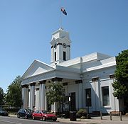
and charges. The Council meets at the Glen Eira Town Hall
Glen Eira Town Hall
Glen Eira Town Hall, known originally as Caulfield Town Hall, is located in Caulfield, Victoria, Australia. The hall was finished in 1890 and is a designated historic building with the Heritage Council of Victoria.-Further reading:...
.
Past and current Glen Eira councillors
| Ward | 1997 - 2000 | 2000 - 2003 | 2003 - 2005 | Ward | 2004 - 2008 | 2008 - 2012 |
|---|---|---|---|---|---|---|
| Orrong | Alan Grossbard JP, Noel Erlich | Alan Grossbard JP, Dorothy Marwick, Noel Erlich | Alan Grossbard JP, Dorothy Marwick, Noel Erlich | Camden | Michael Lipshutz, Helen Whiteside, Jacquie Robilliard | Frank Penhalluriack Frank Penhalluriack Francis William Penhalluriack is most notable for opening his Glen Huntly, Victoria hardware store outside of legislated trading hours.Frank Penhalluriack's actions eventually led to a dramatic change in retail trading laws in Victoria, Australia.... , Michael Lipshutz, Helen Whiteside (resigned July 2010, Cheryl Forge (August 2010 - present) |
| Jasper | Barry Neve JP, Russell Longmuir | David Bloom, Rachelle Sapir, Eamonn Walsh | Jamie Hyams, Bob Bury, Margaret Esakoff | Rosstown | Margaret Esakoff, Steven Tang Steven Tang Cr. Steven Tang is a city councillor and current mayor of the City of Glen Eira in Melbourne, Australia. He was elected second into Rosstown Ward in November 2005... , Rob Spaulding |
Margaret Esakoff, Steven Tang Steven Tang Cr. Steven Tang is a city councillor and current mayor of the City of Glen Eira in Melbourne, Australia. He was elected second into Rosstown Ward in November 2005... , Neil Piling |
| Mackie | Veronika Martens, Norman Kennedy | Veronika Martens, Norman Kennedy, Peter Goudge JP | Veronika Martens, Rachelle Sapir, Peter Goudge JP | Tucker | David Feldman (resigned April 2008), Nick Staikos, Kate Ashmor, Henry Buch (May 2008 - November 2008) | Nick Staikos (resigned September 2009), Jim Magee, Jamie Hyams, Oscar Lobo JP (October 2009 – present) |
History
This area was originally occupied by the WurundjeriWurundjeri
The Wurundjeri are a people of the Indigenous Australian nation of the Woiwurrung language group, in the Kulin alliance, who occupy the Birrarung Valley, its tributaries and the present location of Melbourne, Australia...
, Indigenous Australians
Indigenous Australians
Indigenous Australians are the original inhabitants of the Australian continent and nearby islands. The Aboriginal Indigenous Australians migrated from the Indian continent around 75,000 to 100,000 years ago....
of the Kulin
Kulin
The Kulin nation, was an alliance of five Indigenous Australian nations in Central Victoria, Australia, prior to European settlement. Their collective territory extended to around Port Phillip and Western Port, up into the Great Dividing Range and the Loddon and Goulburn River valleys. To their...
nation, who spoke variations of the Woiwurrung
Woiwurrung
Woiwurrung is an Indigenous Australian language spoken by some of the Kulin Nation clans, the Wurundjeri people, of Central Victoria, from Mount Baw Baw in the east to Mount Macedon, Sunbury and Gisborne in the west.The Woiwurrung clans inhabited the Yarra River, called Birrarung in Woiwurrung,...
language group.
Settlement
Victoria was proclaimed a separate colony in 1851.East St Kilda commenced to be settled in the 1850s. The area of Glen Eira was once swamps, with farms in the northern area and market gardens in the south. Dirt tracks wound through the swamps and sandy heaths of the district. They were constantly damaged by farmers' cart wheels, creating dangerous holes and making access difficult.
In 1853 the Victorian Parliament passed an Act to give authority to locally elected people to extract rates from residents in order to finance road construction. Residents lobbied for a roads district to be proclaimed to ensure that roads were maintained and passable.
Caulfield
Caulfield, Victoria
Caulfield is a suburb in Melbourne, Victoria, Australia, 12 km south-east from Melbourne's central business district. Its Local Government Area is the City of Glen Eira...
's organised communal existence began as a District Roads Board in 1857 and the first Caulfield Roads Board was elected in November 1857. It had control over the roads in an area bounded by Warrigal Road, Hotham Street, Dandenong Road, North Road and Brighton Road. The proclamation of the Caulfield Roads Board tied the name 'Caulfield' to a specific area.
Moorabbin
Moorabbin, Victoria
Moorabbin is a suburb in Melbourne, Victoria, Australia, 15 km south-east from Melbourne's central business district. Its Local Government Area is the City of Kingston. At the 2006 Census, Moorabbin had a population of 5,170....
became a Roads Board in 1862. The board's boundaries extended from the outskirts of Brighton
Brighton
Brighton is the major part of the city of Brighton and Hove in East Sussex, England on the south coast of Great Britain...
and south-east along both sides of the Nepean Road as far as Mordialloc Creek, taking in the coastal areas now known as Hampton
Hampton, Victoria
Hampton is a suburb in Melbourne, Victoria, Australia, 14 km south east from Melbourne's central business district. Its Local Government Area is the City of Bayside. At the 2006 Census, Hampton had a population of 11,825.Hampton is located in a wealthy bayside area of Melbourne, wedged between the...
, Sandringham
Sandringham, Victoria
Sandringham is a suburb in Melbourne, Victoria, Australia, 16 km south-east from Melbourne's central business district. Its Local Government Area is the City of Bayside. At the 2006 Census, Sandringham had a population of 8693.-History:...
, Beaumaris
Beaumaris, Victoria
Beaumaris is a suburb in Melbourne, Victoria, Australia, 20 km south-east from Melbourne's central business district. Its Local Government Area is the City of Bayside. At the 2006 Census, Beaumaris had a population of 12,441....
and Mentone
Mentone, Victoria
Mentone is a suburb in Melbourne, Victoria, Australia, 21 km south-east from Melbourne's central business district. Its Local Government Area is the City of Kingston...
.
Caulfield became a Shire in 1863 and a City in 1913. Moorabbin became a Shire in 1874 and a City in 1934.
The first railway link to the area were at Caulfield and Carnegie railway stations, which opened in 1879, to be followed in 1881 by Glenhuntly and Ormond railway stations.
For the first 25 years of Caulfield's municipal life, board/shire members met in "Mood Kee", the house of Cr Harold Pennington. He was paid 10 pounds a year to cover the cost of candles, fuel and the room. The annual general meeting was held in a tent in the backyard. The Caulfield Town Hall (now the Glen Eira Town Hall
Glen Eira Town Hall
Glen Eira Town Hall, known originally as Caulfield Town Hall, is located in Caulfield, Victoria, Australia. The hall was finished in 1890 and is a designated historic building with the Heritage Council of Victoria.-Further reading:...
) was built in 1885. The building was modified several times to meet the growing demands of the municipality, as was Moorabbin Town Hall.
Moorabbin, part of the earliest development of Melbourne, began as an outpost of "Dendy's Brighton" and took shape as a market garden area along what was Arthur's Seat Road, now the Nepean Highway
Nepean Highway
Nepean Highway runs south from the centre of Melbourne in Victoria, Australia to Portsea, along the eastern shore of Port Phillip. It is the primary road route to central Melbourne from Melbourne's southern suburbs.- History :...
. For more than a century, the sandy soil of Moorabbin provided metropolitan Melbourne with much of its fruit and vegetables.
After World War II, Moorabbin became one of the first 'boom suburbs'. By the 1950s, along with the Sydney
Sydney
Sydney is the most populous city in Australia and the state capital of New South Wales. Sydney is located on Australia's south-east coast of the Tasman Sea. As of June 2010, the greater metropolitan area had an approximate population of 4.6 million people...
suburb of Bankstown
Bankstown, New South Wales
Bankstown is a suburb of south-western Sydney, in the state of New South Wales, Australia. Bankstown is located 20 kilometres south-west of the Sydney central business district and is the administrative centre of the local government area of the City of Bankstown.-History:Prior to European...
, it became the fastest growing municipality in Australia.
Road conditions were just one the major challenges to face the elected bodies in a developing area. As the farms and market gardens gave way to housing and the district's population grew, street lighting (originally gas), drainage, sewerage, rubbish collection, tips and other services were provided.
Today, the City of Glen Eira is an established area. Glen Eira City Council is responsible for maintaining an ageing infrastructure and strives to update with works on roads, drains and footpaths.
Public health issues have always been a key part of Council's activities. A clean water supply and sanitary removal of sewage was critical last century because of outbreaks of disease, such as typhoid, diphtheria and scarlet fever. These functions have now been taken by Melbourne Water
Melbourne Water
Melbourne Water is a government owned statutory authority that controls much of the water system in Melbourne, Victoria, Australia including the reservoirs, and thesewerage and drainage system that services the city.- Overview :...
.
Council has for a long time had a role in controlling the impact of animals on health and well-being. Late last century, Caulfield Council was paying a reward for the heads of rats. Dog registration was instituted in 1865.
Social caring and support roles have continued to grow, from maternal and child health centres — the first opened around 1924 — to providing work for the unemployed during the Depression
Great Depression
The Great Depression was a severe worldwide economic depression in the decade preceding World War II. The timing of the Great Depression varied across nations, but in most countries it started in about 1929 and lasted until the late 1930s or early 1940s...
, digging trenches in Caulfield Park during World War II, setting up welfare funds and operating Meals on Wheels
Meals on Wheels
Meals on Wheels are programs that deliver meals to individuals at home who are unable to purchase or prepare their own meals. The name is often used generically to refer to home-delivered meals programs, not all of which are actually named "Meals on Wheels"...
from 1957.
Immunisation services have been provided since the last century. Council libraries began in the district with the Bentleigh Library in July 1961; the Caulfield service followed in 1963.
Providing public open spaces has also been a long tradition. Paddy's Swamp (now Caulfield Park) was set aside as a reserve in the 1880s. Many other sites once used as tips were turned into parks and gardens. Some parks were provided partly to cater for the large crowds at municipal band performances. As involvement in sport developed, so did the reserves' facilities.
The evolution of the City
- 1857 Caulfield District Roads Board
- 1862 Moorabbin District Roads Board
- 1863 Shire of Caulfield
- 1874 Shire of Moorabbin
- 1913 City of CaulfieldCaulfield, VictoriaCaulfield is a suburb in Melbourne, Victoria, Australia, 12 km south-east from Melbourne's central business district. Its Local Government Area is the City of Glen Eira...
- 1934 City of MoorabbinMoorabbin, VictoriaMoorabbin is a suburb in Melbourne, Victoria, Australia, 15 km south-east from Melbourne's central business district. Its Local Government Area is the City of Kingston. At the 2006 Census, Moorabbin had a population of 5,170....
- 1994 City of Glen Eira, by merger of Caulfield, and north section of Moorabbin
Names
CaulfieldThe origin of the name of Caulfield is not known for certain, but the name seemed to be linked with Baron Caulfeild of Ireland, perhaps through John Caulfield, a pioneer of the colony.
The name 'Caulfield' was in use by 1853, and the early maps always place it somewhere around the racecourse. It was not in general use for the whole area until the proclamation of the Caulfield Road District in 1857.
Moorabbin
The name "Moorabbin" derives from an Aboriginal word which principally means 'a resting place'. The proper name is probably 'moorooboon', a term used by the tribal group of the area, the Bunurong
Bunurong
The Bunurong are Indigenous Australians of the Kulin nation, who occupy South-Central Victoria, Australia. Prior to European settlement, they lived as all people of the Kulin nation lived, sustainably on the land, predominantly as hunters and gatherers, for tens of thousands of years...
. The first European settlers may have found 'moorooboon' difficult to pronounce and accordingly corrupted the word for ease of use. The name Moorabbin applied from the earliest days of the Port Phillip settlement and remains today.
Glen Huntly
Glen Huntly
Glen Huntly, Victoria
Glen Huntly is a suburb in Melbourne, Victoria, Australia, 11 km south-east from Melbourne's central business district. Its Local Government Area is the City of Glen Eira. At the 2006 Census, Glen Huntly had a population of 4085....
is named after a ship, the Glen Huntly, that arrived in Port Phillip
Port Phillip
Port Phillip Port Phillip Port Phillip (also commonly referred to as Port Phillip Bay or (locally) just The Bay, is a large bay in southern Victoria, Australia; it is the location of Melbourne. Geographically, the bay covers and the shore stretches roughly . Although it is extremely shallow for...
in 1840, after setting off from Greenock, Scotland. She was carrying 190 new immigrants, skilled manual labourers who were heading for the new colony settled in Melbourne. Fever, most likely typhoid, struck the ship mid journey and only 50 people survived to reach Port Phillip Bay. The Glen Huntly was forced to land at Little Red Bluff (now Point Ormond) and Victoria's first quarantine station was formed to deal with the crisis. Supplies and provisions were brought down what is now Glen Huntly Road and the small town was formed.
Until recently Glen Huntly was spelt 'Glenhuntly'. The Council voted to change the spelling of the name of the suburb and of the road that bears the name to bring it to the historical spelling. However, the vote did not affect the spelling of the train station which continues to be spelt 'Glenhuntly'. The section of the Glen Huntly/Glenhuntly Road which comes within the boundaries of the City of Port Phillip
City of Port Phillip
The City of Port Phillip is a Local Government Area in Victoria, Australia. It is located on the northern shores of Port Phillip, south of Melbourne's central business district. It has an area of 20.62 km² and has an estimated population of 96,110 people....
continued for a time to be spelt 'Glenhuntly Road', but has now been changed to bring it into line with the rest of the road.
Bentleigh
One of Moorabbin's early identities was Thomas Bent
Thomas Bent
Sir Thomas Bent KCMG , Australian politician, was the 22nd Premier of Victoria. He was one of the most colourful and corrupt politicians in Victorian history....
, who was simultaneously a Councillor on both Moorabbin
Moorabbin, Victoria
Moorabbin is a suburb in Melbourne, Victoria, Australia, 15 km south-east from Melbourne's central business district. Its Local Government Area is the City of Kingston. At the 2006 Census, Moorabbin had a population of 5,170....
and Brighton
Brighton, Victoria
Brighton is a suburb of Melbourne, Victoria, Australia, 11 km south-east from Melbourne's central business district. Its Local Government Area is the City of Bayside. At the 2006 Census, Brighton had a population of 20,651...
Councils for more than 40 years, as well becoming a State Member of Parliament and Premier. The suburb of Bentleigh
Bentleigh, Victoria
Bentleigh is a suburb in Melbourne, Victoria, Australia, 13 km south-east from Melbourne's central business district. Its Local Government Area is the City of Glen Eira. At the 2006 Census, Bentleigh had a population of 14,271.-History:...
is named after him.
Carnegie
Carnegie was originally called Rosstown, after William Murray Ross, a developer. The name was changed to Carnegie in 1909 in an unsuccessful attempt to secure funds for a library from the philanthropist Andrew Carnegie
Andrew Carnegie
Andrew Carnegie was a Scottish-American industrialist, businessman, and entrepreneur who led the enormous expansion of the American steel industry in the late 19th century...
. The original name lives on in the name of the local hotel, and Rosstown Road. Leila Road is named after Mr Ross's wife, and Grange Road is named after Ross's estate, The Grange, which has since been subdivided and is now suburban housing estates. Carnegie Primary School (No. 2897) was established in 1888 as Rosstown State School. The Carnegie theatre was, in the 1930s, a popular cinema, but has since been converted into offices.
Train network
Caulfield railway station originally opened on 7 May 1879.Glenhuntly railway station opened on 19 December 1881 as Glen Huntly Road. It was later renamed to Glen Huntly in 1882 before being renamed again to Glenhuntly in 1937.
Ormond railway station opened on 19 December 1881 as North Road. It was later renamed to Ormond
Ormond, Victoria
Ormond is a suburb in Melbourne, Victoria, Australia, 12 km south-east from Melbourne's central business district. Its Local Government Area is the City of Glen Eira. At the 2006 Census, Ormond had a population of 7152....
in 1897.
Carnegie railway station opened on 14 May 1879 as Rosstown. It was later renamed to Carnegie
Carnegie, Victoria
Carnegie is a suburb in Melbourne, Victoria, Australia, 12 km south-east from Melbourne's central business district. Its Local Government Area is the City of Glen Eira. At the 2006 Census, Carnegie had a population of 15,084...
in 1909.
Monash University, Caulfield Campus
The Monash University, Caulfield Campus was founded as the Caulfield Technical School in 1922. A Junior Technical High School was added in the 1950s, with the Technical School becoming a Senior Technical High School. They separated in 1958 with the junior school absorbed by other technical schools in the area and the senior school became Caulfield Technical College. In the 1970s it became the Caulfield Institute of Technology. In 1982 the Caulfield Institute of Technology amalgamated with the State College of Victoria at Frankston to form the Chisholm Institute of Technology. This Institution merged with Monash University in 1990 and became Monash University, Caulfield campus. http://www.monash.edu.au/alumni/reunion/Caulfieldhistory.htmlMerger
In 1994 the local government structure was radically altered. The City of Glen Eira was formed from the City of CaulfieldCaulfield, Victoria
Caulfield is a suburb in Melbourne, Victoria, Australia, 12 km south-east from Melbourne's central business district. Its Local Government Area is the City of Glen Eira...
and the northern part of the City of Moorabbin. In March 1997 Glen Eira's first Council was elected by residents and ratepayers.
Sacking of Council - 2004
In September 2004, the then Minister for Local Government, Candy BroadCandy Broad
Candy Celeste Broad is an Australian politician. She has been an Australian Labor Party member of the Victorian Legislative Council since September 1999, first representing the electorate of Melbourne North Province until 2006, and then as a Member for the Northern Victoria region.After making a...
, was asked to appoint an inspector by the Glen Eira City Council to investigate and report on matters arising out of an internal audit of councillors' expenses. In July 2005, the Inspector of Municipal Administration, Merv Whelan, forwarded a report to the Minister. The key findings portrayed a complete breakdown of communication and behavioural standards within the elected council, although Whelan found the council was well-managed and in a sound financial position because of its CEO and administration. A report in The Age
The Age
The Age is a daily broadsheet newspaper, which has been published in Melbourne, Australia since 1854. Owned and published by Fairfax Media, The Age primarily serves Victoria, but is also available for purchase in Tasmania, the Australian Capital Territory and border regions of South Australia and...
newspaper alleged that several councillors had used their phone entitlements for non-council purposes.
On 11 August 2005, the then Minister sacked the council, and appointed John Lester, the former Chief Commissioner of Darebin City Council
City of Darebin
The City of Darebin is a Local Government Area in Victoria, Australia, located in the northern suburbs of Melbourne. It has an area of , and as of 2009, has a population of 139,608...
and former chair of the Victorian Grants Commission, as Administrator. An election for a new council was held on 26 November 2005 with redrawn ward boundaries. Only one councillor from the previous council, Margaret Esakoff, was re-elected. Three other sacked councillors (Noel Erlich, Veronika Martens and Bob Bury) did run again but failed to get elected into council.
Federal Parliament
The Australian House of Representatives is elected from 150 single-member districts called Divisions. The Divisions which fall in Glen Eira, the current sitting member and their political party are as follows:- Division of GoldsteinDivision of GoldsteinThe Division of Goldstein is an Australian Electoral Division in Victoria. The division was created in 1984, when the former Division of Balaclava was abolished. It is named for Vida Goldstein, an early feminist parliamentary candidate. It is located in the bayside suburbs of Melbourne, including...
- Mr Andrew RobbAndrew RobbAndrew John Robb AO , Australian politician and former federal Director of the Liberal Party of Australia, was elected to the House of Representatives as member for the Division of Goldstein, Victoria for the Liberal Party of Australia at the 2004 federal election.Robb, one of nine children, was...
AO MP, Liberal Party of AustraliaLiberal Party of AustraliaThe Liberal Party of Australia is an Australian political party.Founded a year after the 1943 federal election to replace the United Australia Party, the centre-right Liberal Party typically competes with the centre-left Australian Labor Party for political office... - Division of HigginsDivision of HigginsThe Division of Higgins is an Australian Electoral Division in Victoria.The division was created in 1949 and is named after Justice H. B. Higgins , who was a Victorian Member of the legislative assembly , president of the Carlton Football Club , Australian Member of Parliament , and justice of the...
- The Hon Peter CostelloPeter CostelloPeter Howard Costello AC is an Australian politician and lawyer who served as the Treasurer in the Australian government from 1996 to 2007. He is the longest-serving Treasurer in Australian history. Costello was a Member of the Australian House of Representatives from 1990 to 2009, representing...
MP, Liberal Party of Australia - Division of HothamDivision of HothamThe Division of Hotham is an Australian Electoral Division in Victoria. The division was created in 1969 and is named for Sir Charles Hotham, Governor of Victoria 1854-55. It is located in the south-eastern suburbs of Melbourne. Hotham covers an area of approximately 72 square kilometres from...
- The Hon Simon CreanSimon CreanSimon Findlay Crean is an Australian politician, and the current Minister for the Arts and Minister for Regional Australia, Regional Development and Local Government in the Australian Federal Government. He was leader of the Australian Labor Party and Leader of the Opposition at the Federal level,...
MP, Australian Labor PartyAustralian Labor PartyThe Australian Labor Party is an Australian political party. It has been the governing party of the Commonwealth of Australia since the 2007 federal election. Julia Gillard is the party's federal parliamentary leader and Prime Minister of Australia... - Division of Melbourne PortsDivision of Melbourne PortsThe Division of Melbourne Ports is an Australian federal electoral division in the inner south-eastern suburbs of Melbourne, Victoria, Australia....
- Mr Michael DanbyMichael DanbyMichael David Danby is an Australian politician and has been an Australian Labor Party member of the Australian House of Representatives since October 1998, representing the Division of Melbourne Ports, Victoria...
MP, Australian Labor Party
Victorian State Parliament
The Legislative Assembly, or lower house, is one of the two chambers of the parliament of Victoria. The Assembly has 88 members, each elected from a single-member electorate or District. The Districts which fall in Glen Eira, the current sitting member, their political party and electoral address are as follows:- Bentleigh DistrictElectoral district of BentleighThe Electoral district of Bentleigh is an electoral district of the Victorian Legislative Assembly. It is an inner-suburban seat based around the suburbs of Bentleigh, McKinnon and most of Moorabbin south east of Melbourne....
- Elizabeth MillerElizabeth Miller (politician)Elizabeth Miller is an Australian state politician who was elected in the Victorian state election, 2010 for the Electoral district of Bentleigh, defeating the Labor MP Rob Hudson. She is a member of the Liberal Party of Australia....
MP - Caulfield DistrictElectoral district of Caulfield-See also:* Parliaments of the Australian states and territories* List of members of the Victorian Legislative Assembly-External links:*...
- Helen ShardeyHelen ShardeyHelen Jean Shardey is a state politician for the Liberal Party of Australia who held the seat of Caulfield from 1996 to 2010...
MP, Liberal Party of Australia - Oakleigh DistrictElectoral district of OakleighThe Electoral district of Oakleigh is an electoral district of the Victorian Legislative Assembly. It covers the suburbs of Carnegie, Murrumbeena, Hughesdale, Oakleigh East, Oakleigh and parts of Chadstone, Glen Waverley, Mount Waverley, Glen Huntly and Ormond.The seat is Labor Party...
- Ann BarkerAnn BarkerAnn Patricia Barker is an Australian politician. She has been an Australian Labor Party member of the Victorian Legislative Assembly since 1999, representing the electorate of Oakleigh. She previously represented the electorate of Bentleigh from 1988 to 1992.Barker was born in Tasmania...
MP, Australian Labor Party
State Legislative Council - Southern Metropolitan Region
- Andrea CooteAndrea CooteAndrea Coote is an Australian politician. She has been a Liberal member of the Victorian Legislative Council since September 1999, representing Monash Province until the 2006 election and the Southern Metropolitan Region since....
MLC - David DavisDavid DavisDavid Davis may refer to:*David Davis , Liberal member of the Victorian Legislative Council*David Davis , British Conservative Member of Parliament, Conservative leadership candidate in 2001 and 2005*David Davis , head of the BBC's Children's Hour*David Davis ,...
MLC - Evan ThornleyEvan ThornleyEvan William Thornley , former Australian politician and entrepreneur, was a Labor member of the Victorian Legislative Council for the Southern Metropolitan Region...
MLC - John LendersJohn LendersJohn Lenders is an Australian Labor Party politician representing the Southern Metropolitan Region in the Victorian Legislative Council. He was most notably the Minister for Education in the Bracks Government and Treasurer of Victoria in the Brumby Government....
MLC - Sue PennicuikSue PennicuikSusan Margaret "Sue" Pennicuik is an Australian politician, and Greens member of the Victorian Legislative Council.-Early career:...
MLC
Public transport
Glen Eira is well-served by an efficient network of public transport in a mix of trams, trains and buses.Train lines and stations
Glen Eira is served by 3 train lines. These are the:- Frankston Line
- Pakenham/Cranbourne Lines
- Sandringham Line
The Frankston Line is served by: Caulfield Railway Station (Zone 1), Glenhuntly Railway Station (Zone 1), Ormond Railway Station (Zone 1 & 2), McKinnon Railway Station (Zone 1 & 2), Bentleigh Railway Station (Zone 1 & 2) and then by Patterson Railway Station (Zone 2).
The Pakenham/Cranbourne Lines are both served by: Caulfield Railway Station (Zone 1), Carnegie Railway Station (Zone 1) and then by Murrumbeena Railway Station (Zone 1).
The Sandringham Line is served by: Elsternwick Railway Station (Zone 1).
Tram routes
- Route 3Melbourne tram route 3Tram route 3 is a public transport service in Melbourne, Victoria, Australia. It runs from the University of Melbourne north of the city centre to Malvern East in the eastern suburbs....
- East Malvern to Melbourne University which travels along Waverley Rd, Balaclava Rd, Carlisle St before proceeding along St Kilda Rd into the Central Business District - Route 16Melbourne tram route 16Tram route 16 is a public transport service in Melbourne, Victoria, Australia. It runs from the University of Melbourne in the city centre to Kew in the eastern suburbs. It runs through the suburbs of Melbourne, St Kilda, Balaclava, Malvern, and Kew...
- Kew to St Kilda and Melbourne University which travels along Glenferrie Rd, Hawthorn Rd and Balaclava Rd, Carlisle St, The Esplanade, Fitzroy St before proceeding along St Kilda Rd into the Central Business District - Route 64Melbourne tram route 64Tram route 64 is a public transport service in Melbourne, Victoria, Australia. It runs from the University of Melbourne in the city centre to East Brighton in the southern suburbs. It runs through the suburbs of Melbourne, Windsor, Caulfield, and Brighton East...
- East Brighton to Melbourne University which runs along Hawthorn Rd and Dandenong Rd, before proceeding along St Kilda Rd into the Central Business District - Route 67Melbourne tram route 67The Melbourne Tram Route 67 is an Australian tram route which runs back and forth from Carnegie to the University of Melbourne.The route starts at the Carnegie terminus, located in Trugininni Road at the corner of Koornang Road, and travels via Glen Huntly Road, Brighton Road, St Kilda Road and...
- Carnegie to Melbourne University which runs along Glen Huntly Rd and Brighton Rd, before proceeding along St Kilda Rd into the Central Business District
Schools
Government funded schools in the city of Glen Eira:- East Bentleigh Primary School
- Tucker Rd Bentleigh Primary School
- Bentleigh Secondary College
- St Peters Primary
- Coatesville Primary School
- Bentleigh West Primary School
- Valkstone Primary School
- Glen Eira College
- Caulfield South Primary School
- Caulfield Primary School
- Caulfield Park Community Secondary School
- Caulfield Junior College
- Glen Huntly Primary School
- Carnegie Primary School
- Rippon Lea Primary School
- Mckinnon Secondary College
- Mckinnon Primary School
- Murrembeena Primary School
- Ormond Primary School
Private
- Wesley CollegeWesley College, MelbourneWesley College, Melbourne is an independent, co-educational, Christian day school in Melbourne, Victoria, Australia. Established in 1866, the college is a school of the Uniting Church in Australia. Wesley is the largest school in Australia by enrolment, with 3,511 students and 564 full-time staff...
- Elsternwick Campus - St James Catholic College
- O.L of Sacred Heart College
- St Aloysius Cath Primary School
- Melbourne Grammar SchoolMelbourne Grammar SchoolMelbourne Grammar School is an independent, Anglican, day and boarding school predominantly for boys, located in South Yarra and Caulfield, suburbs of Melbourne, Victoria, Australia....
- Grimwade House - Caulfield Grammar Senior SchoolCaulfield Grammar SchoolCaulfield Grammar School is an independent, co-educational, Anglican, day and boarding school, located in Melbourne, Victoria, Australia. Founded in 1881 as a boys' school, Caulfield began admitting girls exactly one hundred years later...
- Wesley College - Elsternwick Campus
- St Josephs School
- Yavneh College
- Adass Israel School
- Sholem Aleichem College
- St Patricks Catholic Primary School
- St Kevins Catholic Primary School
- Kilvington Girls' GrammarKilvington Girls' GrammarKilvington Grammar is an independent, Baptist, co-educational day school, located in Ormond, a suburb in the Glen Eira region of Melbourne, Victoria, Australia....
- Katandra School
- Yeshivah College
- Beth Rivkah College
- Mount Scopus College - St Kilda East Campus
- St Pauls Catholic Primary School
- St Patricks Catholic Primary School
- Shelford Girls' GrammarShelford Girls' GrammarShelford Girls' Grammar is an independent, Anglican, day school for girls, located in Caulfield, a suburb of Melbourne, Victoria, Australia.Established in 1898, the school currently caters for approximately 600 students from pre-school to year 12....
Council public library branches
- Bentleigh - 161 Jasper Road, Bentleigh
- Carnegie - a large suburban library and civic centre, which was built in 2005 - 7 Shepparson Avenue, Carnegie
- Caulfield - At the City Hall, Corner Glen Eira and Hawthorn Roads, Caulfield
- Elsternwick - 4 Staniland Grove, Elsternwick
Membership
Library membership is free. It can be organised at a branch and requires proof of the applicant's residence in Victoria. Persons under 18 need the signature of a guarantor e.g. parent.
Private libraries open to the public
- Kadimah Jewish Cultural Centre and National Library - 7 Selwyn St, Elsternwick
- Makor Jewish Community Library- 306 Hawthorn Rd, Caulfield http://www.makorlibrary.com/