
City of Port Phillip
Encyclopedia
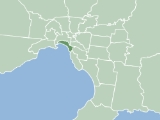
The City of Port Phillip is a Local Government Area in Victoria, Australia. It is located on the northern shores of Port Phillip
, south of Melbourne
's central business district. It has an area of 20.62 km² and has an estimated population of 96,110 people.
Port Phillip contains a number of varied and substantial retail, entertainment and leisure precincts. These include Bay Street (Port Melbourne), Victoria Avenue (Albert Park), Clarendon Street (South Melbourne), Armstrong Street (Middle Park), Fitzroy Street (St Kilda), Acland Street (St Kilda), Carlisle Street (Balaclava) and Ormond Road (Elwood). A number of significant employment areas lay within Port Phillip, including the St Kilda Road office district and industrial, warehousing and manufacturing districts in South Melbourne and Port Melbourne. The city has experienced a significant amount of residential development in the 1990s, particularly in areas close to the foreshore.
Port Phillip is well served by public transport with a substantial tram network, the St Kilda
and Port Melbourne light rail lines and two stations on the Sandringham
rail line, in addition to bus services.
Comprising seven wards, it is predominantly an amalgamation of three former cities - St Kilda
, parts of South Melbourne
, most of Port Melbourne
, plus a small portion of Windsor
from the former City of Prahran
. http://www.portphillip.vic.gov.au/about_copp.htm1#L6.
The city was created in the present borders in June 1994 under the municipal restructure by the then Jeff Kennett
Liberal
government. At the time the city was administered by the then Commissioner Des Clarke and two other commissioners. The first council elections were held in March 1996.
The City of Port Phillip is bounded by White Reserve and Todd Road to the west, the West Gate Freeway, Kings Way and Dorcas Street to the north, St Kilda Road, High Street, Punt Road, Queens Way, Dandenong Road, Orrong Road, Inkerman Street, Hotham Street, Glen Huntly Road, St Kilda Street and Head Street generally to the east and the foreshore of Port Phillip
to the south. Adjacent councils include the City of Melbourne
, City of Bayside
, City of Glen Eira
and the City of Stonnington
.
Council offices are currently located in the St Kilda Town Hall
, Port Melbourne Town Hall
and the South Melbourne Town Hall
. The council operates several other facilities including local libraries, child care centres, parks, playgrounds and community centres.
, Japan. http://obu.portphillip.vic.gov.au/
Port Phillip
Port Phillip Port Phillip Port Phillip (also commonly referred to as Port Phillip Bay or (locally) just The Bay, is a large bay in southern Victoria, Australia; it is the location of Melbourne. Geographically, the bay covers and the shore stretches roughly . Although it is extremely shallow for...
, south of Melbourne
Melbourne
Melbourne is the capital and most populous city in the state of Victoria, and the second most populous city in Australia. The Melbourne City Centre is the hub of the greater metropolitan area and the Census statistical division—of which "Melbourne" is the common name. As of June 2009, the greater...
's central business district. It has an area of 20.62 km² and has an estimated population of 96,110 people.
Port Phillip contains a number of varied and substantial retail, entertainment and leisure precincts. These include Bay Street (Port Melbourne), Victoria Avenue (Albert Park), Clarendon Street (South Melbourne), Armstrong Street (Middle Park), Fitzroy Street (St Kilda), Acland Street (St Kilda), Carlisle Street (Balaclava) and Ormond Road (Elwood). A number of significant employment areas lay within Port Phillip, including the St Kilda Road office district and industrial, warehousing and manufacturing districts in South Melbourne and Port Melbourne. The city has experienced a significant amount of residential development in the 1990s, particularly in areas close to the foreshore.
Port Phillip is well served by public transport with a substantial tram network, the St Kilda
St Kilda, Victoria
St Kilda is an inner city suburb of Melbourne, Victoria, Australia, 6 km south from Melbourne's central business district. Its Local Government Area is the City of Port Phillip...
and Port Melbourne light rail lines and two stations on the Sandringham
Sandringham
Sandringham can refer to:Places*Sandringham, Johannesburg, a suburb of Johannesburg, Gauteng Province, South Africa*Sandringham, Norfolk, a village in Norfolk, England*Sandringham House in the aforementioned village, owned by the British Royal Family...
rail line, in addition to bus services.
Comprising seven wards, it is predominantly an amalgamation of three former cities - St Kilda
City of St Kilda
The City of St Kilda was a Local Government Area located on Port Phillip about south of Melbourne, the state capital of Victoria, Australia. The city covered an area of , and existed from 1855 until 1994.-History:...
, parts of South Melbourne
City of South Melbourne
The City of South Melbourne was a Local Government Area located about south of Melbourne, the state capital of Victoria, Australia, on the south bank of the Yarra River...
, most of Port Melbourne
City of Port Melbourne
The City of Port Melbourne was a Local Government Area located about southwest of Melbourne, the state capital of Victoria, Australia, on the south bank of the Yarra River...
, plus a small portion of Windsor
Windsor, Victoria
Windsor is a suburb in Melbourne, Victoria, Australia, 5 km south-east from Melbourne's central business district. Its Local Government Area is the City of Stonnington. At the 2006 Census, Windsor had a population of 6394....
from the former City of Prahran
City of Prahran
The City of Prahran was a Local Government Area located about southeast of Melbourne, the state capital of Victoria, Australia. The city covered an area of , and existed from 1855 until 1994.-History:...
. http://www.portphillip.vic.gov.au/about_copp.htm1#L6.
The city was created in the present borders in June 1994 under the municipal restructure by the then Jeff Kennett
Jeff Kennett
Jeffrey Gibb Kennett AC , a former Australian politician, was the Premier of Victoria between 1992 and 1999. He is currently the President of Hawthorn Football Club. He is the founding Chairman of beyondblue, a national depression initiative.- Early life :Kennett was born in Melbourne on 2 March...
Liberal
Liberal Party of Australia
The Liberal Party of Australia is an Australian political party.Founded a year after the 1943 federal election to replace the United Australia Party, the centre-right Liberal Party typically competes with the centre-left Australian Labor Party for political office...
government. At the time the city was administered by the then Commissioner Des Clarke and two other commissioners. The first council elections were held in March 1996.
The City of Port Phillip is bounded by White Reserve and Todd Road to the west, the West Gate Freeway, Kings Way and Dorcas Street to the north, St Kilda Road, High Street, Punt Road, Queens Way, Dandenong Road, Orrong Road, Inkerman Street, Hotham Street, Glen Huntly Road, St Kilda Street and Head Street generally to the east and the foreshore of Port Phillip
Port Phillip
Port Phillip Port Phillip Port Phillip (also commonly referred to as Port Phillip Bay or (locally) just The Bay, is a large bay in southern Victoria, Australia; it is the location of Melbourne. Geographically, the bay covers and the shore stretches roughly . Although it is extremely shallow for...
to the south. Adjacent councils include the City of Melbourne
City of Melbourne
The City of Melbourne is a Local Government Area in Victoria, Australia, located in the central city area of Melbourne. The city has an area of 36 square kilometres and has an estimated population of 93,105 people. The city's motto is "Vires acquirit eundo" which means "She gathers strength as she...
, City of Bayside
City of Bayside
The City of Bayside is a Local Government Area in Victoria, Australia. It is located in the southern suburbs of Melbourne. It has an area of 36 square kilometres and has a estimated population of 96,329 people.-City of Brighton:...
, City of Glen Eira
City of Glen Eira
The City of Glen Eira is a Local Government Area in Victoria, Australia. It is located in the south-eastern suburbs of Melbourne. It has an area of 38.4 square kilometres and has a estimated population of 136,354 people...
and the City of Stonnington
City of Stonnington
The City of Stonnington is a Local Government Area located within the metropolitan area of Melbourne, Victoria, Australia. It comprises the inner south-eastern suburbs, between 3 and 13 kilometres from the Melbourne CBD...
.
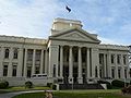
Council offices are currently located in the St Kilda Town Hall
St Kilda Town Hall
St Kilda Town Hall is a city hall in St Kilda, Victoria, Australia.-Architecture:The design by local architect William Pitt in the Classical Revival style. It was built in 1890. Pitt's grand vision for the town hall was never completed...
, Port Melbourne Town Hall
Port Melbourne Town Hall
The Port Melbourne Town Hall was erected in 1882. The Town Hall is an important element in the historic Bay Street streetscape of inner city Port Melbourne....
and the South Melbourne Town Hall
South Melbourne Town Hall
South Melbourne Town Hall is a civic building located at Bank Place in South Melbourne, a suburb of Melbourne, Australia. It is of state heritage significance to Victoria being listed on the Victorian Heritage Register .-Architecture:...
. The council operates several other facilities including local libraries, child care centres, parks, playgrounds and community centres.
Schools
- Albert Park Primary School, http://albertparkps.vic.edu.au
- Elwood Primary School, http://elwoodps.vic.edu.au
- Galilee Regional Primary School (Roman Catholic), http://www.galilee.melb.catholic.edu.au
- Middle Park Primary School, http://middleparkps.vic.edu.au
- Port Melbourne Primary School (formerly Graham St Primary), http://portmelb.vic.edu.au
- St Kilda Park Primary School, http://skipps.vic.edu.au
- St Kilda Primary School, http://stkildaps.vic.edu.au
- Albert Park Secondary College, http://www.albertpark.vic.edu.au The School Council voted on 11 October 2006 that the school close (see The Age 12 October - http://theage.com.au/news/national/teachers-council-vote-toshut-school/2006/10/11/1160246197070.html), although there is much residual opposition which has resulted in a protest march to Thwaites office and the formation of a grass roots movement to save the school from closure called "save albert park college". The re-build school is due to re-open in 2011 but with only an intake of year 7 (form 1) students in that year.
- Elwood Secondary College, http://www.elwood.vic.edu.au
- Mac.Robertson Girls' High SchoolMac.Robertson Girls' High SchoolThe Mac.Robertson Girls' High School is an academically selective, public high school for girls, located in the city of Melbourne, Victoria, Australia....
(elite government girls secondary college with an entry test) - St Michael's Grammar SchoolSt Michael's Grammar SchoolSt Michael's Grammar School is a co-educational independent day school located in St Kilda, Victoria, Australia.The school was founded in 1895 by the Community of the Sisters of the Church and is associated with the Anglican Church of Australia. St Michael's is located on a single campus, its...
(Church of England/Anglican)
Offices
- St Kilda Town Hall
- South Melbourne Town Hall
- Port Melbourne Town Hall
Libraries
- St Kilda
- Albert Park
- Emerald Hill (South Melbourne)
- Middle Park
- Port Melbourne
Notable institutions
- Greek Orthodox Archdiocese of Victoria, South Melbourne
- Hare Krishna Temple, Albert Park
- Australian National Music Academy, South Melbourne (in former City of South Melbourne Town Hall)
- 2/10 Medium Regiment, Royal Australian Artillery (Army Reserve), Chapel Street, East St Kilda
- City of Port Phillip Town Hall, St Kilda (Former City of St Kilda Town HallSt Kilda Town HallSt Kilda Town Hall is a city hall in St Kilda, Victoria, Australia.-Architecture:The design by local architect William Pitt in the Classical Revival style. It was built in 1890. Pitt's grand vision for the town hall was never completed...
) (council meeting usually on the 4th Monday of the month with 2 committee meetings earlier in the month) See website http://www.portphillip.vic.gov.au/meetings_agendas.htm - Former City of Port Melbourne Town Hall, Port Melbourne
- Former City of South Melbourne Town HallSouth Melbourne Town HallSouth Melbourne Town Hall is a civic building located at Bank Place in South Melbourne, a suburb of Melbourne, Australia. It is of state heritage significance to Victoria being listed on the Victorian Heritage Register .-Architecture:...
, South Melbourne
Notable events
- St Kilda FestivalSt Kilda FestivalThe St Kilda Festival is a popular community festival held in the Melbourne suburb of St Kilda. Traditionally held on the second Sunday in February, the festival is about showcasing live Australian music, family and children's entertainment, beach activities and much more all presented in a...
(300,000 people attend this annual music event, Fitzroy Street and Upper Esplanade closed, tram services to the event) - St Kilda Film Festival (Australia's Top 100 short films, SoundKILDA: Australia Music Video Competition, international films, forums, Industry Open Day...and so much more.)
- Gay Pride March (Fitzroy Street and Catani Gardens, St Kilda, dykes on bikes, boot scooting, marching groups, music and political activism.)
- St Kilda Writers Festival (local and international writers compare their skills)
- Melbourne Formula 1 Grand Prix (Albert Park Reserve) 4 day international motor racing event held in early March; usually on the Labour Day/Moomba holiday long weekend.
Suburbs and localities
- Albert ParkAlbert Park, VictoriaAlbert Park is an inner city suburb of Melbourne, Victoria, Australia, 3 km south from Melbourne's central business district. Its Local Government Area is the City of Port Phillip. At the 2006 Census, Albert Park had a population of 5827....
- BalaclavaBalaclava, VictoriaBalaclava is a suburb of Melbourne, Victoria, in Australia. It is situated in the south-east of the city in the St Kilda East area and is bounded by Inkerman Street to the north, Chapel Street to the west, Hotham Street to the east and Oak Grove and Los Angeles Court to the south. In terms of its...
- Beacon Cove
- ElwoodElwood, VictoriaElwood is a suburb in Melbourne, Victoria, Australia, 8 km south from Melbourne's central business district. Its Local Government Area is the City of Port Phillip...
- Garden City
- Middle ParkMiddle Park, VictoriaMiddle Park is a suburb in Melbourne, Victoria, Australia, 5 km south from Melbourne's central business district. Its Local Government Area is the City of Port Phillip. At the 2006 Census, Middle Park had a population of 4012...
- Port Melbourne - part
- RipponleaRipponlea, VictoriaRipponlea is a suburb of Melbourne, Victoria, Australia. It is centered on the intersection of Glen Eira Road and Hotham Street, in the municipality of City of Port Phillip. In terms of its cadastral division, Ripponlea is in the parish of Prahran within the County of Bourke. As of the 2006 Census,...
- part - SouthbankSouthbank, VictoriaSouthbank is an inner city suburb of Melbourne, Victoria, Australia located direct south of the Yarra River opposite Melbourne's Hoddle Grid. The northernmost area is considered part of the Central Business District and Central Activities District of the city. Its Local Government Area are the...
- part - South MelbourneSouth Melbourne, VictoriaSouth Melbourne is an inner city suburb in Melbourne, Victoria, Australia, 2 km south from Melbourne's central business district. Its Local Government Area are the Cities of Port Phillip and Melbourne...
- St KildaSt Kilda, VictoriaSt Kilda is an inner city suburb of Melbourne, Victoria, Australia, 6 km south from Melbourne's central business district. Its Local Government Area is the City of Port Phillip...
- St Kilda EastSt Kilda East, VictoriaSt Kilda East is a suburb in Melbourne, Victoria, Australia, 6 km south-east of Melbourne's central business district. It is located within the Local Government Areas of the City of Glen Eira and the City of Port Phillip. At the 2006 Census, it had a population of 12,188.St Kilda East is one...
- part - St Kilda Road
- St Kilda West
- WindsorWindsor, VictoriaWindsor is a suburb in Melbourne, Victoria, Australia, 5 km south-east from Melbourne's central business district. Its Local Government Area is the City of Stonnington. At the 2006 Census, Windsor had a population of 6394....
- part
Current Council
The Council is composed of seven councillors, each elected to represent one of the seven existing wards. The following councillors were elected in December 2008. This followed a ward restructure which occurred earlier in the year.- Albert Park Ward: Cr Judith Klepner
- Carlisle Ward: Cr Rachel Powning (Mayor)
- Catani Ward: Cr Serge Thomann
- Emerald Hill Ward: Cr Frank O'Connor
- Junction Ward: Cr John Middleton
- Point Ormond Ward: Cr Jane Touzeau
- Sandridge Ward: Cr Janet Bolitho
Sister cities
Obu, AichiObu, Aichi
is a city located in Aichi, Japan.As of 2003, the city has an estimated population of 77,324 and the density of 2,295.84 persons per km². The total area is 33.68 km².The city was founded on September 1, 1970.-External links:*...
, Japan. http://obu.portphillip.vic.gov.au/
- Devonport, TasmaniaDevonport, Tasmania-Sport:The Devonport Football Club is an Australian Rules team competing in the Tasmanian Statewide League. The Devonport Rugby Club is a Rugby Union team competing in the Tasmanian Rugby Union Statewide League...
Australia (destination for "Spirit of TasmaniaSpirit of TasmaniaSpirit of Tasmania may refer to:* The trading name of TT-Line Pty. Ltd.* One of the following ferries that sailed under the name of Spirit of Tasmania during its careers:** ** ** **...
" ferries from Station Pier, Port Melbourne)
See also
- List of localities (Victoria) for other Melbourne suburbs and municipalities.
- List of Mayors of Port Phillip
External links
- Port Phillip Online - official website
- Metlink local public transport map
- Link to Land Victoria interactive maps
- Sister Cities by the Sea - information on the relationship between Obu and Port Phillip (English and Japanese content).
- PortPhillip.com