
City of Caulfield
Encyclopedia
Melbourne
Melbourne is the capital and most populous city in the state of Victoria, and the second most populous city in Australia. The Melbourne City Centre is the hub of the greater metropolitan area and the Census statistical division—of which "Melbourne" is the common name. As of June 2009, the greater...
, the state capital of Victoria
Victoria (Australia)
Victoria is the second most populous state in Australia. Geographically the smallest mainland state, Victoria is bordered by New South Wales, South Australia, and Tasmania on Boundary Islet to the north, west and south respectively....
, Australia
Australia
Australia , officially the Commonwealth of Australia, is a country in the Southern Hemisphere comprising the mainland of the Australian continent, the island of Tasmania, and numerous smaller islands in the Indian and Pacific Oceans. It is the world's sixth-largest country by total area...
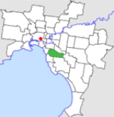
. The city covered an area of 21.97 square kilometres (8.48 sq mi), and existed from 1857 until 1994.
History
Caulfield was incorporated as a Roads District on 15 October 1857, and became a shire on 17 April 1871. In the 1880s the area was a market gardeningMarket gardening
A market garden is the relatively small-scale production of fruits, vegetables and flowers as cash crops, frequently sold directly to consumers and restaurants. It is distinguishable from other types of farming by the diversity of crops grown on a small area of land, typically, from under one acre ...
district with 182 hectares (450 acre) under cultivation, but by the end of the century, its character had become more residential. As such, it became a borough on 30 April 1901 and a town on 23 September 1901. It was proclaimed a City on 26 July 1913. On 16 April 1923, it lost part of its area (the current suburb of Hughesdale
Hughesdale, Victoria
Hughesdale is a suburb in Melbourne, Victoria, Australia, 18 km south-east from Melbourne's central business district. Its Local Government Area is the City of Monash. At the 2006 Census, Hughesdale had a population of 6,503....
) to the Oakleigh Borough
City of Oakleigh
The City of Oakleigh was a Local Government Area located about southeast of Melbourne, the state capital of Victoria, Australia. The city covered an area of , and existed from 1891 until 1994.-History:...
.
On 15 December 1994, along with nearly all other councils in Victoria, the City of Caulfield was abolished and merged with nearby parts of Moorabbin
City of Moorabbin
The City of Moorabbin was a Local Government Area located about southeast of Melbourne, the state capital of Victoria, Australia. The city covered an area of , and existed from 1862 until 1994.-History:...
to form the City of Glen Eira
City of Glen Eira
The City of Glen Eira is a Local Government Area in Victoria, Australia. It is located in the south-eastern suburbs of Melbourne. It has an area of 38.4 square kilometres and has a estimated population of 136,354 people...
.
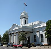
Council meetings were held at Caulfield Town Hall on Glen Eira Road and Hawthorn Road, Caulfield. It presently serves as a service centre for the City of Glen Eira
City of Glen Eira
The City of Glen Eira is a Local Government Area in Victoria, Australia. It is located in the south-eastern suburbs of Melbourne. It has an area of 38.4 square kilometres and has a estimated population of 136,354 people...
.
Wards
The City of Caulfield was subdivided into four wards on 31 May 1977, each electing three councillors:- North Ward
- South Ward
- East Ward
- West Ward
Suburbs
- CarnegieCarnegie, VictoriaCarnegie is a suburb in Melbourne, Victoria, Australia, 12 km south-east from Melbourne's central business district. Its Local Government Area is the City of Glen Eira. At the 2006 Census, Carnegie had a population of 15,084...
- CaulfieldCaulfield, VictoriaCaulfield is a suburb in Melbourne, Victoria, Australia, 12 km south-east from Melbourne's central business district. Its Local Government Area is the City of Glen Eira...
- Caulfield EastCaulfield East, VictoriaCaulfield East is a suburb in Melbourne, Victoria, Australia, 10 km south-east from Melbourne's central business district. Its Local Government Area is the City of Glen Eira. At the 2006 Census, Caulfield East had a population of 1242....
- Caulfield NorthCaulfield North, VictoriaCaulfield North is a suburb in Melbourne, Victoria, Australia, 9 km south-east from Melbourne's central business district. Its Local Government Area is the City of Glen Eira. At the 2006 Census, Caulfield North had a population of 14,034....
- Caulfield SouthCaulfield South, VictoriaCaulfield South is a suburb in Melbourne, Victoria, Australia, 10 km south-east from Melbourne's central business district. Its Local Government Area is the City of Glen Eira. At the 2006 Census, Caulfield South had a population of 11,113....
- ElsternwickElsternwick, VictoriaElsternwick is a suburb in Melbourne, Victoria, Australia, 9 km south-east from Melbourne's central business district. Its Local Government Area is the City of Glen Eira...
- GardenvaleGardenvale, VictoriaGardenvale is a suburb in Melbourne, Victoria, Australia, 10 km south-east from Melbourne's central business district. Its Local Government Area is the City of Glen Eira...
- Glen HuntlyGlen Huntly, VictoriaGlen Huntly is a suburb in Melbourne, Victoria, Australia, 11 km south-east from Melbourne's central business district. Its Local Government Area is the City of Glen Eira. At the 2006 Census, Glen Huntly had a population of 4085....
- MurrumbeenaMurrumbeena, VictoriaMurrumbeena is a suburb in Melbourne, Victoria, Australia, 13 km south-east from Melbourne's central business district. Its Local Government Area is the City of Glen Eira...
- OrmondOrmond, VictoriaOrmond is a suburb in Melbourne, Victoria, Australia, 12 km south-east from Melbourne's central business district. Its Local Government Area is the City of Glen Eira. At the 2006 Census, Ormond had a population of 7152....
(split with City of MoorabbinCity of MoorabbinThe City of Moorabbin was a Local Government Area located about southeast of Melbourne, the state capital of Victoria, Australia. The city covered an area of , and existed from 1862 until 1994.-History:...
) - St Kilda EastSt Kilda East, VictoriaSt Kilda East is a suburb in Melbourne, Victoria, Australia, 6 km south-east of Melbourne's central business district. It is located within the Local Government Areas of the City of Glen Eira and the City of Port Phillip. At the 2006 Census, it had a population of 12,188.St Kilda East is one...
(split with City of St KildaCity of St KildaThe City of St Kilda was a Local Government Area located on Port Phillip about south of Melbourne, the state capital of Victoria, Australia. The city covered an area of , and existed from 1855 until 1994.-History:...
)
Population
| Year | Population |
|---|---|
| 1911 | 15,919 |
| 1933 | 65,297 |
| 1954 | 75,217 |
| 1958 | 72,900* |
| 1961 | 74,859 |
| 1966 | 76,058 |
| 1971 | 81,865 |
| 1976 | 73,630 |
| 1981 | 69,922 |
| 1986 | 67,718 |
| 1991 | 67,776 |
* Estimate in the 1958 Victorian Year Book.