

Fort Washington Way
Encyclopedia
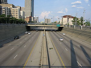
Fort Washington Way is a one-mile section of freeway in downtown Cincinnati, Ohio
. Running east-west in a trench, it carries Interstate 71
and US-50, first built between 1958 and 1961. It is named for a former fort
which once stood nearby.
Its western terminus is with Interstate 75
. At this location, Interstate 71
is multiplexed with Interstate 75
and turns south, crossing the Ohio River
on the Brent Spence Bridge
. US-50 continues westbound as the Sixth Street Expressway
and then as River Road
.
Fort Washington Way's eastern terminus is at the Lytle Tunnel
, where Interstate 71
turns north. US-50 continues east across the Third Street Viaduct onto Columbia Parkway
.
 Much of Cincinnati's historic riverfront below Third Street, was cleared in the late 1950s for the construction of Fort Washington Way.
Cincinnati, Ohio
Cincinnati is a city in the U.S. state of Ohio. Cincinnati is the county seat of Hamilton County. Settled in 1788, the city is located to north of the Ohio River at the Ohio-Kentucky border, near Indiana. The population within city limits is 296,943 according to the 2010 census, making it Ohio's...
. Running east-west in a trench, it carries Interstate 71
Interstate 71
Interstate 71 is an Interstate Highway in the Great Lakes/Midwestern and Southeastern region of the United States. Its southern terminus is at an interchange with Interstate 64 and Interstate 65 in Louisville, Kentucky. Its northern terminus is at an interchange with Interstate 90 in Cleveland,...
and US-50, first built between 1958 and 1961. It is named for a former fort
Fort Washington, Cincinnati, Ohio
Fort Washington was a fort in the early history of Cincinnati, Ohio. The location is marked by a plaque at the Guilford School building, at 421 E 4th St, Cincinnati, which now occupies the site...
which once stood nearby.
Its western terminus is with Interstate 75
Interstate 75
Interstate 75 is a major north–south Interstate Highway in the Great Lakes and Southeastern regions of the United States. It travels from State Road 826 and State Road 924 in Hialeah, Florida to Sault Ste. Marie, Michigan, at the Ontario, Canada, border...
. At this location, Interstate 71
Interstate 71
Interstate 71 is an Interstate Highway in the Great Lakes/Midwestern and Southeastern region of the United States. Its southern terminus is at an interchange with Interstate 64 and Interstate 65 in Louisville, Kentucky. Its northern terminus is at an interchange with Interstate 90 in Cleveland,...
is multiplexed with Interstate 75
Interstate 75
Interstate 75 is a major north–south Interstate Highway in the Great Lakes and Southeastern regions of the United States. It travels from State Road 826 and State Road 924 in Hialeah, Florida to Sault Ste. Marie, Michigan, at the Ontario, Canada, border...
and turns south, crossing the Ohio River
Ohio River
The Ohio River is the largest tributary, by volume, of the Mississippi River. At the confluence, the Ohio is even bigger than the Mississippi and, thus, is hydrologically the main stream of the whole river system, including the Allegheny River further upstream...
on the Brent Spence Bridge
Brent Spence Bridge
The Brent Spence Bridge is a double decker cantilever truss bridge that carries Interstates 71 and 75 across the Ohio River between Covington, Kentucky and Cincinnati, Ohio. The top deck carries southbound traffic while the bottom deck carries northbound traffic. It is arguably the most important...
. US-50 continues westbound as the Sixth Street Expressway
Sixth Street Expressway
The Sixth Street Expressway is a six-lane urban controlled-access highway that runs from Interstate 75 in Queensgate, just west of downtown Cincinnati, Ohio, to the Waldvogel Viaduct, which continues to Lower Price Hill. The expressway opened to traffic in 1964, replacing Sixth Street for most of...
and then as River Road
River Road
River Road may refer to the following locations:* River Road * River Road * Maryland Route 190* River Road, Minnesota* Pennsylvania Route 32* River Road, North Carolina* River Road, Oregon* River Road...
.
Fort Washington Way's eastern terminus is at the Lytle Tunnel
Lytle Tunnel
The Lytle Tunnel is a vehicular tunnel that carries Interstate 71 under the historic Lytle Park in Cincinnati, Ohio, United States. It is a six-lane tunnel with three tubes. There is a two lane southbound tube, a three lane northbound tube, and a one lane southbound tube that separates from the...
, where Interstate 71
Interstate 71
Interstate 71 is an Interstate Highway in the Great Lakes/Midwestern and Southeastern region of the United States. Its southern terminus is at an interchange with Interstate 64 and Interstate 65 in Louisville, Kentucky. Its northern terminus is at an interchange with Interstate 90 in Cleveland,...
turns north. US-50 continues east across the Third Street Viaduct onto Columbia Parkway
Columbia Parkway
Columbia Parkway is an expressway/parkway extending from Downtown Cincinnati, Ohio to the Village of Fairfax, and serving as US-50 on Cincinnati's east side. It was constructed in the Art Deco architectural style in 1938 as part of the New Deal...
.