

C-Train
Encyclopedia
- This article is about the light rail system in Calgary. For other uses, see C Train (disambiguation).
C-Train is the light rail transit
Light Rail Transit
The name Light Rail Transit is used to refer to several light rail systems, as an official name or otherwise:* Please see List of tram and light-rail transit systems.-See also:* Light Rapid Transit * Light railway* Light rail...
(LRT) system in Calgary
Calgary
Calgary is a city in the Province of Alberta, Canada. It is located in the south of the province, in an area of foothills and prairie, approximately east of the front ranges of the Canadian Rockies...
, Alberta, Canada. It has been in operation since May 25, 1981. The system is operated by Calgary Transit
Calgary Transit
Calgary Transit is the public transit service which is owned and operated by the city of Calgary, Alberta. In 2008, an estimated 95.3 million passengers boarded approximately 960 Calgary Transit vehicles , which thus provided 2.31 million hours of service .-History:What would eventually become...
, a department of the Calgary municipal government.
Operations
The C-Train system currently operates on 48.8 kilometres (30.3 mi) of track, organized into two routes. The light rail track isn't an isolated network as a connection to the conventional Canadian Pacific Rail line exists via a track switch near Heritage Station.The longest route numbered 201 serves the southern and northwestern areas, while the shorter route, 202, serves the northeastern sections of the city. Most track is at grade with its own right-of-way. The downtown
Downtown Calgary
Downtown Calgary is a region of central Calgary, Alberta. It is not a single neighbourhood per se, but is actually a larger community containing three neighbourhoods and a number of districts....
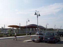
portion is shared right-of-way serving both routes along the 7th Avenue transit mall at street level. This portion is a zero-fare zone and serves as a downtown people mover
People mover
A people mover or automated people mover is a fully automated, grade-separated mass transit system.The term is generally used only to describe systems serving relatively small areas such as airports, downtown districts or theme parks, but is sometimes applied to considerably more complex automated...
. The tracks split at the east and west ends of downtown into lines leading to the south, northeast and northwest residential neighbourhoods of Calgary. An additional line is currently being implemented to extend route 202 to the western neighbourhoods. Eight percent (8%) of the system is underground, and 5% is grade-separated (elevated). Trains are powered by overhead electric wires, using pantograph
Pantograph (rail)
A pantograph for rail lines is a hinged electric-rod device that collects electric current from overhead lines for electric trains or trams. The pantograph typically connects to a one-wire line, with the track acting as the ground wire...
s to draw power. In the early 2000s, Calgary Transit began using the spelling CTrain for the LRT system, although this variation has not passed into general use and local media continue to use C-Train.
In the third quarter of 2010, the C-Train system had an average of 252,600 revenue riders per weekday, the second busiest light rail system in North America
Light rail in North America
Light rail is a commonly used mode of rapid transit in North America. The term light rail was coined in 1972 by the U.S. Urban Mass Transportation Administration to describe new streetcar transformations which were taking place in Europe and the United States...
behind the Monterrey Metro
Monterrey Metro
The Monterrey Metro is a fully grade-separated light rail, or metro, system in Monterrey, Nuevo León, Mexico. It is the newest of Mexico's metro systems, with operation beginning in 1991. As of October 2008, the system operated 40 high-floor electric trains along 31 km of routes...
.
History
The idea of rail transit in Calgary originated in a 1967 Calgary transportation study, which recommended a two-line metroRapid transit
A rapid transit, underground, subway, elevated railway, metro or metropolitan railway system is an electric passenger railway in an urban area with a high capacity and frequency, and grade separation from other traffic. Rapid transit systems are typically located either in underground tunnels or on...
system to enter service in 1978. The original plans had called for two lines, a northwest-to-south line (on a similar routing to the present-day Northwest and South lines) between the original Banff Trail station (at Crowchild Trail
Crowchild Trail
Crowchild Trail is an expressway located on the west side of Calgary, Alberta, Canada.The road was originally signed as 24th Street SW from North Glenmore Park to the Bow River, 24th Street NW from the Bow to the intersection with 16th Avenue NW , and Highway 1A from 16th Ave NW to the city limits...
and Northland Drive, between the present-day Brentwood
Brentwood (C-Train)
Brentwood is a stop on the Northwest Line of the C-Train light rail system in Calgary, Alberta, Canada. The station is located to serve the city's Brentwood neighbourhood. From 1990 to 2003, this was the terminus of the Northwest Line of the C-Train system.The stop is located in the middle of the...
and Dalhousie
Dalhousie (C-Train)
Dalhousie is a station along the Northwest Line of the C-Train light rail system in Calgary, Alberta, and it was the northern terminus of route 201 from December 15, 2003 until June 14, 2009....
stations) and Southwood station (at Southland Drive, roughly at the location of the present-day Southland station
Southland (C-Train)
Southland is a stop on the South Line of the C-Train light rail system in Calgary, Alberta. Southland station is located approximately 9 km from downtown Calgary....
, with five stations in downtown underneath 7 Avenue; and the west line, which ran from downtown to the community of Glendale, primarily along the 26 Avenue SW corridor. A fourth line, a north central line running from downtown to Thorncliffe mostly along Centre Street
Centre Street (Calgary)
Centre Street is a major road in Calgary, Alberta.The northern part extends from the Bow River to Bergen Road/Beddington Drive, after which it becomes a local arterial street before it becomes unavailable to private vehicular traffic north of Bergen Crescent...
was also envisioned, but was thought to be beyond the scope of the study. However, a building boom in the 1970s had caused the heavy rail concept to fall out of favour due to the increased costs of construction, with light rail as its replacement. LRT was chosen over dedicated busways and the expansion of the Blue Arrow bus service (a service similar to bus rapid transit
Bus rapid transit
Bus rapid transit is a term applied to a variety of public transportation systems using buses to provide faster, more efficient service than an ordinary bus line. Often this is achieved by making improvements to existing infrastructure, vehicles and scheduling...
today) because light rail has lower long-term operating costs and to address traffic congestion problems – indeed, the Blue Arrow service all but disappeared in 2000.
The present-day C-Train originated in a 1975 plan, calling for construction of a single line, from the downtown core (8 Street station
8 Street Southwest (C-Train)
8 Street Southwest is a stop in Downtown Calgary on the city's C-Train light rail system. The station is used only by eastbound trains. The platform for the station is located on the south side of 7th Avenue SW....
) to Anderson Road (the present-day Anderson station
Anderson (C-Train)
Anderson is a station on the South Line of the C-Train light rail system in Calgary, Alberta.-History:The station was, until October 9, 2001, the southern terminus of the South Line, having served in this capacity since the LRT's original opening in 1981. It is located at the junction of Anderson...
. The plan was approved by City Council in May 1977, with construction of what would become the LRT's South Line beginning one month later. The South line opened on May 25, 1981. Though the South Line was originally planned to extend to the northwest, political pressures led to the commission of the Northeast Line, running from Whitehorn station
Whitehorn (C-Train)
Whitehorn is a station on the Northeast Line of the C-Train light rail system in Calgary, Alberta.The station is located in the median of 36 Street Northeast, between 32 Avenue Northeast and 44 Avenue Northeast...
(at 36 Street NE and 39 Avenue NE) to the downtown core, with a new downtown terminal station for both lines at 10 Street SW
10 Street Southwest (C-Train)
The 10 Street Southwest platform is the western terminus of Route 202 of the C-Train light rail system in Calgary, Alberta.Opened in 1985 with the opening of the Northeast line, this stop was the terminus for Route 201 until the Northwest Line opened in 1987. Until the West Line to 69 Street...
, which opened on April 27, 1985. The Northwest Line, the extension of the South line to the city's northwest, was opened on September 17, 1987, in time for the 1988 Winter Olympics
1988 Winter Olympics
The 1988 Winter Olympics, officially known as the XV Olympic Winter Games, were a winter multi-sport event celebrated in and around Calgary, Alberta, Canada from 13 to 28 February 1988. The host was selected in 1981 after having beat Falun, Sweden and Cortina d'Ampezzo, Italy...
. This line ran from the downtown core to University station
University (C-Train)
University is a stop on the Northwest Line of the C-Train light rail system in Calgary, Alberta.The station is located east of the University of Calgary grounds...
, next to the University of Calgary
University of Calgary
The University of Calgary is a public research university located in Calgary, Alberta, Canada. Founded in 1966 the U of C is composed of 14 faculties and more than 85 research institutes and centres.More than 25,000 undergraduate and 5,500 graduate students are currently...
campus. Since then, all three lines have been extended incrementally, with most of the stations commissioned and built in the 2000s:
| August 31, 1990 | Brentwood station Brentwood (C-Train) Brentwood is a stop on the Northwest Line of the C-Train light rail system in Calgary, Alberta, Canada. The station is located to serve the city's Brentwood neighbourhood. From 1990 to 2003, this was the terminus of the Northwest Line of the C-Train system.The stop is located in the middle of the... |
Northwest Line |
| October 9, 2001 | Canyon Meadows station Canyon Meadows (C-Train) Canyon Meadows is a stop on the South Line of the C-Train light rail system in Calgary, Alberta.It was one of the two new stations that opened on October 9, 2001.... Fish Creek-Lacombe station Fish Creek-Lacombe (C-Train) Fish Creek-Lacombe is a stop on the South Line of the C-Train light rail system in Calgary, Alberta.It was one of the two new stations to open on October 9, 2001. The station was, until June 27, 2004, the southern terminus of the South Line. It is located between Macleod Trail, Millrise Boulevard... |
South Line |
| December 15, 2003 | Dalhousie station Dalhousie (C-Train) Dalhousie is a station along the Northwest Line of the C-Train light rail system in Calgary, Alberta, and it was the northern terminus of route 201 from December 15, 2003 until June 14, 2009.... |
Northwest Line |
| June 28, 2004 | Shawnessy station Shawnessy (C-Train) Shawnessy is a station on the South Line of the C-Train light rail system in Calgary, Alberta.It was one of the two new stations to open on June 28, 2004. The station is located along Shawville Boulevard and serves the communities of Midnapore and Shawnessy.The station's platforms are staggered... Somerset-Bridlewood station Somerset-Bridlewood (C-Train) Somerset-Bridlewood is the current southern terminus of the South Line of the C-Train light rail system in Calgary, Alberta.-History:... |
South Line |
| December 17, 2007 | McKnight-Westwinds station McKnight-Westwinds (C-Train) McKnight-Westwinds is the northern terminus of the North-East Line of the C-Train light rail system in Calgary, Alberta. It opened on December 15, 2007, but opened to the public for use on December 17, 2007..... |
Northeast Line |
| June 15, 2009 | Crowfoot station | Northwest Line |
The system initially used Siemens-Duewag U2
Siemens-Duewag U2
The Siemens-Duewag U2 is a type of light-rail vehicle . The cars were built by consortium of Siemens, Wegmann & Co. and Duewag. The U2 design was built on the Siemens U1 prototype tram built in 1965 ....
LRVs (originally designed for German metro
Rapid transit
A rapid transit, underground, subway, elevated railway, metro or metropolitan railway system is an electric passenger railway in an urban area with a high capacity and frequency, and grade separation from other traffic. Rapid transit systems are typically located either in underground tunnels or on...
s, and used by Edmonton
Edmonton
Edmonton is the capital of the Canadian province of Alberta and is the province's second-largest city. Edmonton is located on the North Saskatchewan River and is the centre of the Edmonton Capital Region, which is surrounded by the central region of the province.The city and its census...
's earlier LRT
Edmonton Light Rail Transit
Edmonton Light Rail Transit, more commonly referred to as the LRT, is a light rail system in Edmonton, Alberta. Part of the Edmonton Transit System , the 20.5-kilometre route starts in Edmonton's northeast suburbs and ends at Century Park in Edmonton's south end.The ETS designates the LRT as Route...
and the U-Bahn
Frankfurt U-Bahn
The Frankfurt U-Bahn, together with the Frankfurt S-Bahn and the Frankfurt Straßenbahn, is the backbone of the public transport system of Frankfurt, Germany. Its name derives from the German term for underground, Untergrundbahn. The U-Bahn opened in 1968 and now consists of 87 stations on nine...
, a light rail system in Frankfurt
Frankfurt
Frankfurt am Main , commonly known simply as Frankfurt, is the largest city in the German state of Hesse and the fifth-largest city in Germany, with a 2010 population of 688,249. The urban area had an estimated population of 2,300,000 in 2010...
), which constituted the entire fleet until mid-July 2001, when the first Siemens SD-160
Siemens SD-160
The SD-100 and SD-160 are light-rail vehicles manufactured by Siemens. The SD-100 uses motors that run on direct-current electricity while the SD-160 model features newer motors that run using alternating current. Both models are suited for loading at street level and high-platform level...
cars were delivered. There are now seventy-two SD-160s and eighty U2s in service (the eighty-third U2 was lost in a March 2001 accident, the eighty second was lost in an accident in late 2006, the eighty-first was lost in late 2007/early 2008).
As of 2007 there is a total of 48.8 km of track; the three lines are 20.7 km (the southern line), 12.5 km (the northeastern line), and 15.0 km (the northwestern line) in length.
Wind power
Wind power is the conversion of wind energy into a useful form of energy, such as using wind turbines to make electricity, windmills for mechanical power, windpumps for water pumping or drainage, or sails to propel ships....
generation. The electricity is generated by Enmax
ENMAX
ENMAX Corporation is a vertically integrated utility that provides electricity, natural gas, renewable energy and value-added services to its customers.-Overview:...
operating in the southernmost region of Alberta. The trains are powered from the same power grid as before; however, an equivalent amount of electricity is produced at the southern wind farms and "dedicated" to the C-Train. Under Alberta's deregulated market for electricity, large consumers can contract to purchase their electricity from a specific vendor, although the individual electrons received off the province-wide grid may not be exactly the same as those transmitted. The only requirement is that supply and demand be the same at each end.
On February 18, 2009, Calgary Transit announced that the C-Train had carried one billion (1,000,000,000) riders in the 28 years since the start of service on May 25, 1981. The trains were now carrying over 280,000 passengers every weekday, higher than any other light rail system in Canada or the United States. Mayor Dave Bronconnier
Dave Bronconnier
David 'Dave' Thomas Bronconnier is a Canadian politician, who served as the 35th Mayor of Calgary, Alberta.- Biography :...
stated that more vehicles were on order to deal with crowding, the northeast and the northwest legs were being extended, and construction of the new west leg was due to start later in the year.
In the following section preliminary timelines for construction of future stations are referenced. For example, construction of a north C-Train line is not expected until after 2023. It should be noted that the city has, on several occasions, accelerated construction of C-Train expansion due to demand and available money. For example the McKnight-Westwinds
McKnight-Westwinds (C-Train)
McKnight-Westwinds is the northern terminus of the North-East Line of the C-Train light rail system in Calgary, Alberta. It opened on December 15, 2007, but opened to the public for use on December 17, 2007.....
station, which opened in 2007, was, as recently as 2002, not planned until beyond 2010. Similarly, the timeline of construction of the south line extension was also pushed up several years due to increasing population and traffic volume. There are plans to develop new routes into the center north and the southeast of the city.
In 2010, the entire CCTV Security Camera network was replaced with new, state of the art, IP based cameras along with a new 10GB Fiber-optic network ring to each leg of the LRT line. The project was completed by Contava Inc and will see continuous future upgrades as new stations and technology become available.
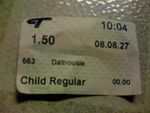
Fares
Rides taken solely within the downtown are free. This is known as the 7th Avenue Free Fare Zone and encompasses all C-Train stations along 7th Avenue. Fares for regular travel are shown in the accompanying table. In addition to the fares below, on March 16, 2009, Calgary Transit began charging a $3 parking fee in all Park and RidePark and ride
Park and ride facilities are car parks with connections to public transport that allow commuters and other people wishing to travel into city centres to leave their vehicles and transfer to a bus, rail system , or carpool for the rest of their trip...
lots, except between the hours of 6 pm and 2 am on weekdays and all day weekends and holidays. A $60 monthly parking pass is also offered. Full-time students attending Alberta College of Art and Design
Alberta College of Art and Design
-History:The Alberta College of Art & Design is a Canadian degree-granting, publicly-funded art and design college located in Calgary . It was known as the Provincial Institute of Technology and Arts, which was part of SAIT until 1985...
, SAIT Polytechnic, Mount Royal University, and the University of Calgary
University of Calgary
The University of Calgary is a public research university located in Calgary, Alberta, Canada. Founded in 1966 the U of C is composed of 14 faculties and more than 85 research institutes and centres.More than 25,000 undergraduate and 5,500 graduate students are currently...
, pay into the UPass program through a fee on their tuition that provides students full access to transit services during each school semester.
| Fare Type | Price (Canadian dollars) |
| Cash Fare | $2.75 |
| Youth Cash Fare | $1.75 |
| Book of 10 Tickets | $24.00 |
| Book of 10 Youth Tickets | $15.00 |
| Day Pass | $8.25 |
| Youth Day Pass | $5.25 |
| Monthly Pass | $90.00 |
| Youth Monthly Pass | $54.25 |
| Monthly Pass, Reduced Rate | $40.00 |
| Senior Citizen Annual Pass | $35.00 |
| Senior Citizen Annual Pass, Reduced Rate | $15.00 |
| UPass – Mount Royal University | $105.00 |
| UPass – SAIT Polytechnic | $105.00 |
| UPass – University of Calgary | $105.00 |
Route details
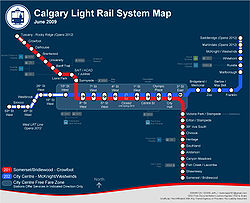
Route 201
This route comprises two lines: the south line, which was the first of the three lines to be built, and the northwest line, which is the newest of the three lines to be built. Currently there are eleven stations on the south line (of which two opened on June 28, 2004) and eight on the northwest line.Downtown Line
As part of the original Route 201 south line, nine stations were built along 7th Avenue S, which formed the 7th Avenue Free Fare Zone. The track runs at grade in a semi-exclusive right of way, shared with buses and city and emergency vehicles.Westbound stations consisted of Olympic Plaza
Olympic Plaza/City Hall (C-Train)
Olympic Plaza and City Hall are stops in downtown Calgary on the city's C-Train light rail system. Before July 2011, the Olympic Plaza stop was only used by westbound trains and the City Hall stop was used...
(known as 1st St SE until 1987), 1st St SW
1 Street Southwest/Centre Street (C-Train)
1 Street and Centre Street are stops in downtown Calgary on the city's C-Train light rail system. The 1 Street platform is used by westbound trains, and the Centre Street platform is used by eastbound trains...
, 4th St SW
3 Street Southwest/4 Street Southwest (C-Train)
The 3 Street Southwest and 4 Street Southwest platforms are stops in downtown Calgary on the city's C-Train light rail system.The 3 Street Southwest platform is used by eastbound trains, and the 4 Street Southwest platform is used by westbound trains...
, and 7th St SW
6 Street Southwest/7 Street Southwest (C-Train)
6 Street Southwest and 7 Street Southwest are stops in downtown Calgary on the city's C-Train light rail system.The 6 Street Southwest stop is used by eastbound trains, and the 7 Street Southwest stop is used by westbound trains. Platforms for the station are located on the sides of 7 Avenue South...
. Since all downtown stations have side platforms, a switch west of the 7th Street SW station allowed a westbound train to cross over to east-bound tracks at the 8th St SW station
8 Street Southwest (C-Train)
8 Street Southwest is a stop in Downtown Calgary on the city's C-Train light rail system. The station is used only by eastbound trains. The platform for the station is located on the south side of 7th Avenue SW....
. The eastbound stations were followed by 6th St SW
6 Street Southwest/7 Street Southwest (C-Train)
6 Street Southwest and 7 Street Southwest are stops in downtown Calgary on the city's C-Train light rail system.The 6 Street Southwest stop is used by eastbound trains, and the 7 Street Southwest stop is used by westbound trains. Platforms for the station are located on the sides of 7 Avenue South...
, 3rd St SW
3 Street Southwest/4 Street Southwest (C-Train)
The 3 Street Southwest and 4 Street Southwest platforms are stops in downtown Calgary on the city's C-Train light rail system.The 3 Street Southwest platform is used by eastbound trains, and the 4 Street Southwest platform is used by westbound trains...
, Centre Street
1 Street Southwest/Centre Street (C-Train)
1 Street and Centre Street are stops in downtown Calgary on the city's C-Train light rail system. The 1 Street platform is used by westbound trains, and the Centre Street platform is used by eastbound trains...
and City Hall
Olympic Plaza/City Hall (C-Train)
Olympic Plaza and City Hall are stops in downtown Calgary on the city's C-Train light rail system. Before July 2011, the Olympic Plaza stop was only used by westbound trains and the City Hall stop was used...
(known as 2nd St SE until 1987). When the northeast leg opened (Route 202), a center platform 10th St SW
10 Street Southwest (C-Train)
The 10 Street Southwest platform is the western terminus of Route 202 of the C-Train light rail system in Calgary, Alberta.Opened in 1985 with the opening of the Northeast line, this stop was the terminus for Route 201 until the Northwest Line opened in 1987. Until the West Line to 69 Street...
was added, and was the terminus for both Route 201 and Route 202 until the northwest extension of Route 201 opened in 1987, it will remain the terminus of Route 202 until 2012.
South Line
Seven stations on this line opened on May 25, 1981, as the first light railway line to serve the city. From north to south, they are Victoria Park/StampedeVictoria Park/Stampede (C-Train)
Victoria Park/Stampede is a stop on the South Line of the C-Train light rail system in Calgary, Alberta....
(originally Stampede), Erlton/Stampede
Erlton/Stampede (C-Train)
Erlton/Stampede is a stop on the South Line of the C-Train light rail system in Calgary, Alberta.The station serves industrial areas and is at the south entrance of Stampede Park, the site of the Calgary Stampede. It serves as an alternate access to the park and is often favored by riders wishing...
(originally Erlton), 39 Avenue
39 Avenue (C-Train)
39 Avenue is a stop on the South Line of the C-Train light rail system in Calgary, Alberta. The station is located east of Macleod Trail and serves the Alyth-Manchester industrial area as well as the Elboya neighbourhood.It is located near the north end of a short tunnel that passes underneath...
(originally 42 Avenue), Chinook
Chinook (C-Train)
Chinook is a stop on the South Line of the C-Train light rail system in Calgary, Alberta.The station is a three-block walk from the Chinook Centre shopping centre, Calgary's largest. A zero-fare bus provides transportation to the mall from the station...
, Heritage
Heritage (C-Train)
Heritage is a stop on the South Line of the C-Train light rail system in Calgary, Alberta.The station, with a large 557 space park-and-ride lot, is located west of Macleod Trail, about east of the Heritage Park Historical Village...
(also the site of the Haysboro LRT Storage Facility), Southland
Southland (C-Train)
Southland is a stop on the South Line of the C-Train light rail system in Calgary, Alberta. Southland station is located approximately 9 km from downtown Calgary....
, and Anderson
Anderson (C-Train)
Anderson is a station on the South Line of the C-Train light rail system in Calgary, Alberta.-History:The station was, until October 9, 2001, the southern terminus of the South Line, having served in this capacity since the LRT's original opening in 1981. It is located at the junction of Anderson...
(also the site of the Anderson LRT Yards). On October 9, 2001, two new stations were added: Canyon Meadows
Canyon Meadows (C-Train)
Canyon Meadows is a stop on the South Line of the C-Train light rail system in Calgary, Alberta.It was one of the two new stations that opened on October 9, 2001....
and Fish Creek-Lacombe
Fish Creek-Lacombe (C-Train)
Fish Creek-Lacombe is a stop on the South Line of the C-Train light rail system in Calgary, Alberta.It was one of the two new stations to open on October 9, 2001. The station was, until June 27, 2004, the southern terminus of the South Line. It is located between Macleod Trail, Millrise Boulevard...
. On June 28, 2004, two more stations opened: Shawnessy
Shawnessy (C-Train)
Shawnessy is a station on the South Line of the C-Train light rail system in Calgary, Alberta.It was one of the two new stations to open on June 28, 2004. The station is located along Shawville Boulevard and serves the communities of Midnapore and Shawnessy.The station's platforms are staggered...
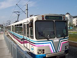
and Somerset-Bridlewood
Somerset-Bridlewood (C-Train)
Somerset-Bridlewood is the current southern terminus of the South Line of the C-Train light rail system in Calgary, Alberta.-History:...
. A further three stations—Silverado (most likely in the area of 194th Avenue SW), 212th Avenue South, and Pine Creek (in the area around 228th Avenue SW) – are planned for the future once the communities adjacent to their location are developed, likely beyond 2020.
Northwest Line
Five stations on this line opened on September 7, 1987. From the most central to the most northwesterly, they are SunnysideSunnyside (C-Train)
Sunnyside is a stop on the Northwest Line of the C-Train light rail system in Calgary, Alberta.The station serves the Sunnyside and Hillhurst neighbourhoods of Calgary, as well as the Kensington shopping district, and is a short walk from Riley Park.-History:The station, and the section of the...
, SAIT/ACAD/Jubilee
SAIT/ACAD/Jubilee (C-Train)
SAIT/ACAD/Jubilee is a stop on the Northwest Line of the C-Train light rail system in Calgary, Alberta. The station's full name is Southern Alberta Institute of Technology/Alberta College of Art and Design/Southern Alberta Jubilee Auditorium. The station serves all of the aforementioned landmarks...
(the station name in full is "Southern Alberta Institute of Technology
Southern Alberta Institute of Technology
-Academics:SAIT Polytechnic offers two full baccalaureate degrees , four applied degrees, 66 diploma and certificate programs, 32 apprenticeship trades and 1,600 continuing education and corporate training courses....
/Alberta College of Art and Design
Alberta College of Art and Design
-History:The Alberta College of Art & Design is a Canadian degree-granting, publicly-funded art and design college located in Calgary . It was known as the Provincial Institute of Technology and Arts, which was part of SAIT until 1985...
/Jubilee Auditorium
Southern Alberta Jubilee Auditorium
The Southern Alberta Jubilee Auditorium is a performing arts, culture and community facility located in Calgary, Alberta, Canada.The auditorium was built in 1955 to celebrate the 50th anniversary of Alberta...
"), Lions Park
Lions Park (C-Train)
Lions Park is a stop on the Northwest Line of the C-Train light rail system in Calgary, Alberta, Canada.It is located south of the Trans-Canada Highway, and adjacent to the Southern Alberta Jubilee Auditorium....
, Banff Trail
Banff Trail (C-Train)
Banff Trail is a stop on the Northwest Line of the C-Train light rail system in Calgary, Alberta.The station is located east of the McMahon Stadium , Burns Stadium, and the Motel Village district, and north-east of the junction of Crowchild Trail and the Trans-Canada Highway...
, and University
University (C-Train)
University is a stop on the Northwest Line of the C-Train light rail system in Calgary, Alberta.The station is located east of the University of Calgary grounds...
. On August 31, 1990, Brentwood
Brentwood (C-Train)
Brentwood is a stop on the Northwest Line of the C-Train light rail system in Calgary, Alberta, Canada. The station is located to serve the city's Brentwood neighbourhood. From 1990 to 2003, this was the terminus of the Northwest Line of the C-Train system.The stop is located in the middle of the...
station was opened as a new terminus, and on December 15, 2003, Dalhousie
Dalhousie (C-Train)
Dalhousie is a station along the Northwest Line of the C-Train light rail system in Calgary, Alberta, and it was the northern terminus of route 201 from December 15, 2003 until June 14, 2009....
Station was opened. An eighth station – Crowfoot (formerly Crowfoot-Centennial) – opened on June 15, 2009. A ninth station – Tuscany (formerly Tuscany-Rocky Ridge) – was approved in November 2007 for completion by 2014. An intermediate station near Northland Drive is possible in the future as well (between Brentwood and Dalhousie).
Route 202
This route comprises one line: the northeast line. Seven of these stations opened on April 27, 1985; from most central to most northeastern, they are: Bridgeland/MemorialBridgeland/Memorial (C-Train)
Bridgeland/Memorial is a stop on the Northeast Line of the C-Train light rail system in Calgary, Alberta. The station is located in the centre of Memorial Drive Northeast. It serves St. Patrick's Island, which is only a short walk away, as is the Calgary Zoo, although it is also accessible via the...
, Zoo
Zoo (C-Train)
Zoo is a stop on the Northeast Line of the C-Train light rail system in Calgary, Alberta. The station, which is located in the centre of Memorial Drive Northeast, serves the Calgary Zoo as well as the community of Bridgeland....
, Barlow/Max Bell
Barlow/Max Bell (C-Train)
Barlow/Max Bell is a stop on the Northeast Line of the C-Train light rail system in Calgary, Alberta.The station is located in the centre of Memorial Drive Southeast, located at the intersection with 19 Street Northeast....
, Franklin
Franklin (C-Train)
Franklin is a stop on the Northeast Line of the C-Train light rail system in Calgary, Alberta, Canada.The station is located in the centre of Memorial Drive, located at the intersection with 27 Street Southeast. Pedestrian bridges connect the station to either side of Memorial Drive...
, Marlborough
Marlborough (C-Train)
Marlborough is a stop on the Northeast Line of the C-Train light rail system in Calgary, Alberta.The station is located in the centre of 36 Street Northeast, located near its intersection with 8 Avenue Northeast/Marlborough Drive Northeast. It is located near Calgary's Marlborough neighborhood and...
, Rundle
Rundle (C-Train)
Rundle is a stop on the Northeast Line of the C-Train light rail system in Calgary, Alberta.The station is located in the median of 36 Street Northeast, between 16 Avenue Northeast and 32 Avenue Northeast, right in front of Sunridge Mall.The station serves the communities of Rundle and Pineridge,...
, and Whitehorn
Whitehorn (C-Train)
Whitehorn is a station on the Northeast Line of the C-Train light rail system in Calgary, Alberta.The station is located in the median of 36 Street Northeast, between 32 Avenue Northeast and 44 Avenue Northeast...
. An eighth station – McKnight/Westwinds
McKnight-Westwinds (C-Train)
McKnight-Westwinds is the northern terminus of the North-East Line of the C-Train light rail system in Calgary, Alberta. It opened on December 15, 2007, but opened to the public for use on December 17, 2007.....
– opened in 2007. Two more stations – expected to be named Martindale
Martindale (C-Train)
Martindale is a future station on the Northeast Line of the C-Train light rail system in Calgary, Alberta. It is expected to open in 2012....
and Saddletowne
Saddletowne (C-Train)
Saddletowne is a future Calgary Transit LRT station located in the northeast community of Saddle Ridge neighbourhood in Calgary, Alberta, Canada. It will be located the northwest corner of Saddletown Circle, a large roundabout which encompasses the 'Town Centre', a commercial activity centre with...
– were approved by city council in November 2007 for completion by 2011. Additional stations are proposed for future development, likely beyond 2023, at 96th Avenue, Country Hills Boulevard, 128th Avenue (north of Skyview Ranch) and Stoney Trail (in the Stonegate Landing development), as those areas are developed.
Future lines
Plans exist to build two additional lines from the city centre: a westbound line (which would extend Route 202), and a southeastern line. A third, northern line is to be planned beyond 2023. Note: station names listed below are subject to change (as Calgary Transit has, on several occasions in the past, renamed approved stations prior to construction).West LRT
The plans for this line, which runs west from downtown, have existed since the beginning of construction of the South Line in 1978. Construction began in 2009 and will open March 2013, instead of December 12, 2012, because of utility work delays for the Bow Trail and 17th Avenue SW corridors.The City of Calgary
Calgary
Calgary is a city in the Province of Alberta, Canada. It is located in the south of the province, in an area of foothills and prairie, approximately east of the front ranges of the Canadian Rockies...
began a review process in late 2006 to update the plans to current standards, and Calgary City Council gave final approval to the project and allocated the required $566-million project funding on November 20, 2007. Funding for the project will be sourced from the infrastructure fund that was created as a result of the Province of Alberta returning the education tax portion of property taxes to the city. Construction of this line began in 2009 and is being constructed at the same time as further extensions of the NE and NW lines of the LRT system that were approved in November 2007.
The West LRT line has six station to be named (from east to west): Sunalta (near 16th Street S.W.), Shaganappi Point, Westbrook, 45th Street West (Glendale), Sirocco, and 69th Street West (west of 69th Street S.W. near Westside Recreation Centre).
The updated alignment from the 2007 West LRT Report includes the line running on an elevated guideway beginning west of the future 11th Street S.W. station, running along the CPR right of way to Bow Trail S.W., and then to 24th Street S.W. The line will then run at grade past Shaganappi Point Station and drop into a tunnel to 33rd Street SW. The tunnel will then run under the Westbrook Mall parking lot, and the current site of the decommissioned Ernest Manning Senior High School. The line will then follow the north side of 17th Avenue S.W. past 37th Street S.W. below grade to 45th Street Station. Past 45th Street the line will run at grade, and approaching Sarcee Trail S.W. will move onto an elevated guideway that will pass over Sarcee Trail S.W. The line will then run at grade to the Sirocco Station, and then proceed to drop below grade and pass under eastbound 17th Avenue S.W. at 69th Street S.W. and return to grade on the south side of the avenue. The line will then terminate at the site of the final station located to the west of 69th Street S.W. (tentatively known as College Station due to the proximity to two private colleges that are located adjacent to the station).
Three of the new West LRT stations will be located at grade. Westbrook
Westbrook (C-Train)
The Westbrook will be the third station on the planned west line of the C-Train light rail system in Calgary, Alberta once the West line is completed in 2012. Ernest Manning High School is currently occupying the site of the station...
, 45 Street SW
45 Street Southwest (C-Train)
45 Street SW will become the fourth station of the West of the C-Train light rail system in Calgary, Alberta once the West line is completed in 2012....
, and 69th St. SW
69 Street Southwest (C-Train)
The 69 St. SW will be the western terminus and sixth station on the planned west line of the C-Train light rail system in Calgary, Alberta once the West line is completed in 2012. The trenched station will be located at the intersection of 69th Street SW and 17th Avenue SW...
stations will be located below grade, while Sunalta
Sunalta (C-Train)
Sunalta will become the second station of the West of the C-Train light rail system in Calgary, Alberta once the West line is completed in 2013....
will be an elevated station.
On October 5, 2009, the city council announced approval of a plan to put a portion of the west LRT line in a trench at 45th Street and 17th Avenue SW, a move welcomed by advocates who fought to have it put underground. The change will cost an estimated $61 million, however lower than expected construction costs are expected to absorb much of the change. The cost for the project is now over budget
Cost overrun
A cost overrun, also known as a cost increase or budget overrun, is an unexpected cost incurred in excess of a budgeted amount due to an under-estimation of the actual cost during budgeting...
by at least C$
Canadian dollar
The Canadian dollar is the currency of Canada. As of 2007, the Canadian dollar is the 7th most traded currency in the world. It is abbreviated with the dollar sign $, or C$ to distinguish it from other dollar-denominated currencies...
35 million and the overall cost could be more than C$
Canadian dollar
The Canadian dollar is the currency of Canada. As of 2007, the Canadian dollar is the 7th most traded currency in the world. It is abbreviated with the dollar sign $, or C$ to distinguish it from other dollar-denominated currencies...
1.46 billion because of soaring costs of land used.
On October 29, 2009 city council announced that the contract to construct the West LRT had been awarded to a consortium led by SNC Lavalin.
Future extension of the West LRT to Aspen Woods Station (around 17th Avenue and 85th Street SW) has been planned, and future extensions further west to 101st Street SW may be added as new communities adjacent to 17th Avenue SW are built.
Southeast Line
This line is planned to run from downtown (although on a different routing, not following the 7th Avenue corridor) to the communities of Douglasdale and McKenzie Lake and McKenzie Towne in the southeast, and onwards past Highway 22X into the so-called "Homesteads" region east of the Deerfoot Trail extension. Eighteen stations have been planned for this route, of which up to eleven are expected to be built by 2023. Three of the proposed downtown stations are expected to be built underground, and the rest of the line will follow the 52 Street SE corridor from Douglasdale and McKenzie Towne to Auburn BayAuburn Bay, Calgary
Auburn Bay is a new suburban residential neighbourhood in the south-east quadrant of Calgary, Alberta. It is located at the south-eastern edge of the city, and is bounded by Seton Boulevard to the south, Deerfoot Trail to the west, the yet-to-be-constructed 52 Street E extension to the east and...
(south of Highway 22X) and then wind its way through Health Campus (adjacent to a planned southeast hospital) and Seton
Seton, Calgary
Seton is a suburban residential/commercial/institutional community currently under construction in southeast Calgary, Alberta. It is located directly south of Auburn Bay and east of Cranston. Its boundaries are presently Deerfoot Trail to the west, Seton Blvd. to the north, and an as-yet unbuilt...
. Unlike Routes 201 and 202, which use high-floor U2 and SD-160 LRVs, the eastern route is expected to employ low-floor LRVs, such as the Siemens Avanto
Avanto (tram)
The Siemens S70 or Avanto is a low-floor light rail vehicle or tram manufactured by Siemens AG. In the United States, Siemens refers to this model only as the S70, while the Avanto name is used in Europe....
.
From north to south, the proposed stations are: Eau Claire, Central (at 6 Avenue), Macleod Trail, 4 Street SE, Ramsay/Inglewood, Crossroads, Highfield, Lynnwood, Ogden, South Hill, Quarry Park, Douglasglen (the last expected by 2023), Shepard, Prestwick, McKenzie Towne, Auburn Bay/Mahogany (at 52nd Street), Health Campus/Seton (the station likely will share the name of the hospital), with further stations to the south expected in the future.
North Line
Although it is not expected to be built until beyond 2023, this line for which a route has not yet been approved by council south of Beddington Trail or north of Stoney Trail, would serve the residential communities of Country Hills, Coventry Hills, Harvest Hills, and Panorama Hills, and could extend north to Airdrie. The line is planned to connect to a proposed multi-mode transportation hub at 96th Avenue before reaching Harvest Hills Boulevard, connecting the airport, bus service, and a proposed high-speed railHigh-speed rail in Canada
Canada is the only G8 country that does not have high-speed rail. In the press and popular discussion, there have been two routes frequently proposed as suitable for a high-speed rail corridor:* Edmonton to Calgary via Red Deer...
service to Edmonton.
Other future improvements
Siemens-Duewag U2
The Siemens-Duewag U2 is a type of light-rail vehicle . The cars were built by consortium of Siemens, Wegmann & Co. and Duewag. The U2 design was built on the Siemens U1 prototype tram built in 1965 ....
s (as of 2008 seventy nine of the original eighty-three are in service, and are nearing twenty-seven years of service, and by 2023 will be forty-two years old). Additional LRVs have been added to the system to accommodate growth, including 72 Siemens SD160 LRVs as of late 2008, with an additional 38 ordered in conjunction with the NW and NE LRT extensions, and the West LRT, which will be completed by 2011 and 2012, respectively.
Downtown station refurbishment
In June 2007 the City of Calgary released information on the schedule for the refurbishment of the remaining original downtown stations. The plan involves replacing and relocating most stations, and expanding Centre Street station which was refurbished in 2001, to board four-car trains. The new stations will retain existing names, however they may be shifted one block east or west, or to the opposite side of 7th Avenue. The first station to undergo refurbishment was the 7th Street SW station, which was relocated one block to the east and re-opened on February 27, 2009. The 6th Street SW, 4th Street SW and 3rd Street SW stations will be reconstructed in place, with 6th Street SW opening in early 2009 and the others following in 2010. This requires that the stations be closed during demolition and reconstruction, however only one station will be closed at any one time. The new stations will feature longer platforms for longer trains, better integration of the platforms into the sidewalk system, better lighting, and more attractive landscaping and street furniture.The 10th Street SW Station, which is currently the terminus for Route 202 in the downtown, will be replaced with a new station located one block to the west at 11th Street SW. This station was initially proposed to be undertaken as the first station to be completed in the refurbishment project, however it has been pushed back and will now be completed closer to 2012 and the opening of the West LRT.
Underground infrastructure
In addition to numerous tunnels to allow trains to pass under roadways, geographic features, and mainline railways, there are other notable underground portions of Calgary's C-Train system.Part of the system through downtown is planned to be transferred underground when needed to maintain reliable service. Given this, portions of the needed infrastructure have been built as adjacent and associated land was developed. As a result of this original plan, when the City of Calgary built a new Municipal Building, it built a short section of tunnel to connect the existing CPR tunnel to the future tunnel under 8th Avenue S. The turnoff to this station is visible in the tunnel on Route 201 entering downtown from the south, shortly before City Hall. However, after urban explorers discovered the tunnel and visited it during a transit strike, the city walled off the spur tunnel with cinder blocks.
As the population of metropolitan Calgary increases and growing suburbs require new lines and extensions, the higher train volumes will exceed the ability of the downtown section along 7th Avenue S to accommodate them. To provide for long-term expansion, the city is reviewing its plans to put parts of the downtown section underground. The current plans allow the expanded Route 202 (Northeast/West) to use the existing 7th Avenue S surface infrastructure. The expanded Route 201 (Northwest/South), currently sharing 7th Avenue S with Route 202, will be relocated to a new tunnel dug beneath 8th Avenue S. The future Southeast/Downtown route will probably enter downtown through a shorter tunnel under one or more streets (candidates include 2nd Street W, 5th Street W, 6th Street W, 8th Avenue S, 10th Avenue S, 11th Avenue S, and 12th Avenue S). The future North line will probably share track from the Zoo station through downtown with the existing Northeast line (Route 202), avoiding the cost of a tunnel until passenger volumes grow. Although Calgary City Council commissioned a functional study for the downtown metro component of the C-Train system in November 2007, the city is unlikely to complete this expansion before 2017 unless additional funding is received from provincial or federal governments.
List of C-Train stations
The typical C-Train station outside the downtown core allows for several methods of passenger arrival and departure. Many C-Train passengers travel to and from suburban stations on feeder bus routes that wend their way through surrounding neighbourhoods. Another popular option is a Park and RidePark and ride
Park and ride facilities are car parks with connections to public transport that allow commuters and other people wishing to travel into city centres to leave their vehicles and transfer to a bus, rail system , or carpool for the rest of their trip...
lot, in which commuters drive to a station by car and then transfer to a C-Train to complete their journey. Alternatively, some C-Train passengers disembark at drop-off zones from vehicles travelling elsewhere; because many of these commuters are conveyed by their spouses, these zones are branded as Kiss and Ride areas.
Route 201
| Station | Route | Area | Open | Location |
|---|---|---|---|---|
| Crowfoot | Route 201 | NW | 2009 | 51°07′21"N 114°12′24"W |
| Dalhousie Dalhousie (C-Train) Dalhousie is a station along the Northwest Line of the C-Train light rail system in Calgary, Alberta, and it was the northern terminus of route 201 from December 15, 2003 until June 14, 2009.... |
Route 201 | NW | 2003 | 51°06′12"N 114°09′39"W |
| Brentwood Brentwood (C-Train) Brentwood is a stop on the Northwest Line of the C-Train light rail system in Calgary, Alberta, Canada. The station is located to serve the city's Brentwood neighbourhood. From 1990 to 2003, this was the terminus of the Northwest Line of the C-Train system.The stop is located in the middle of the... |
Route 201 | NW | 1990 | 51°05′15"N 114°07′56"W |
| University University (C-Train) University is a stop on the Northwest Line of the C-Train light rail system in Calgary, Alberta.The station is located east of the University of Calgary grounds... |
Route 201 | NW | 1987 | 51°04′49"N 114°07′23"W |
| Banff Trail Banff Trail (C-Train) Banff Trail is a stop on the Northwest Line of the C-Train light rail system in Calgary, Alberta.The station is located east of the McMahon Stadium , Burns Stadium, and the Motel Village district, and north-east of the junction of Crowchild Trail and the Trans-Canada Highway... |
Route 201 | NW | 1987 | 51°04′15"N 114°06′55"W |
| Lions Park Lions Park (C-Train) Lions Park is a stop on the Northwest Line of the C-Train light rail system in Calgary, Alberta, Canada.It is located south of the Trans-Canada Highway, and adjacent to the Southern Alberta Jubilee Auditorium.... |
Route 201 | NW | 1987 | 51°03′54"N 114°06′12"W |
| SAIT/ACAD/Jubilee SAIT/ACAD/Jubilee (C-Train) SAIT/ACAD/Jubilee is a stop on the Northwest Line of the C-Train light rail system in Calgary, Alberta. The station's full name is Southern Alberta Institute of Technology/Alberta College of Art and Design/Southern Alberta Jubilee Auditorium. The station serves all of the aforementioned landmarks... |
Route 201 | NW | 1987 | 51°03′47"N 114°05′28"W |
| Sunnyside Sunnyside (C-Train) Sunnyside is a stop on the Northwest Line of the C-Train light rail system in Calgary, Alberta.The station serves the Sunnyside and Hillhurst neighbourhoods of Calgary, as well as the Kensington shopping district, and is a short walk from Riley Park.-History:The station, and the section of the... |
Route 201 | NW | 1987 | 51°03′21"N 114°05′03"W |
| 8th St. SW 8 Street Southwest (C-Train) 8 Street Southwest is a stop in Downtown Calgary on the city's C-Train light rail system. The station is used only by eastbound trains. The platform for the station is located on the south side of 7th Avenue SW.... |
Route 201, 202 | Downtown | 1981 | 51°02′49"N 114°04′52"W |
| 6th/7th St. SW 6 Street Southwest/7 Street Southwest (C-Train) 6 Street Southwest and 7 Street Southwest are stops in downtown Calgary on the city's C-Train light rail system.The 6 Street Southwest stop is used by eastbound trains, and the 7 Street Southwest stop is used by westbound trains. Platforms for the station are located on the sides of 7 Avenue South... |
Route 201, 202 | Downtown | 1981 | 51°02′48"N 114°04′30"W |
| 3rd/4th St. SW 3 Street Southwest/4 Street Southwest (C-Train) The 3 Street Southwest and 4 Street Southwest platforms are stops in downtown Calgary on the city's C-Train light rail system.The 3 Street Southwest platform is used by eastbound trains, and the 4 Street Southwest platform is used by westbound trains... |
Route 201, 202 | Downtown | 1981 | 51°02′48"N 114°04′13"W |
| 1st St. SW/Centre St. 1 Street Southwest/Centre Street (C-Train) 1 Street and Centre Street are stops in downtown Calgary on the city's C-Train light rail system. The 1 Street platform is used by westbound trains, and the Centre Street platform is used by eastbound trains... |
Route 201, 202 | Downtown | 1981 | 51°02′48"N 114°03′51"W |
| Olympic Plaza/City Hall Olympic Plaza/City Hall (C-Train) Olympic Plaza and City Hall are stops in downtown Calgary on the city's C-Train light rail system. Before July 2011, the Olympic Plaza stop was only used by westbound trains and the City Hall stop was used... |
Route 201, 202 | Downtown | 1981 | 51°02′47"N 114°03′29"W |
| Victoria Park/Stampede Victoria Park/Stampede (C-Train) Victoria Park/Stampede is a stop on the South Line of the C-Train light rail system in Calgary, Alberta.... |
Route 201 | S | 1981 | 51°02′18"N 114°03′30"W |
| Erlton/Stampede Erlton/Stampede (C-Train) Erlton/Stampede is a stop on the South Line of the C-Train light rail system in Calgary, Alberta.The station serves industrial areas and is at the south entrance of Stampede Park, the site of the Calgary Stampede. It serves as an alternate access to the park and is often favored by riders wishing... |
Route 201 | S | 1981 | 51°01′56"N 114°03′31"W |
| 39th Avenue 39 Avenue (C-Train) 39 Avenue is a stop on the South Line of the C-Train light rail system in Calgary, Alberta. The station is located east of Macleod Trail and serves the Alyth-Manchester industrial area as well as the Elboya neighbourhood.It is located near the north end of a short tunnel that passes underneath... |
Route 201 | S | 1981 | 51°01′03"N 114°03′42"W |
| Chinook Chinook (C-Train) Chinook is a stop on the South Line of the C-Train light rail system in Calgary, Alberta.The station is a three-block walk from the Chinook Centre shopping centre, Calgary's largest. A zero-fare bus provides transportation to the mall from the station... |
Route 201 | S | 1981 | 50°59′50"N 114°03′58"W |
| Heritage Heritage (C-Train) Heritage is a stop on the South Line of the C-Train light rail system in Calgary, Alberta.The station, with a large 557 space park-and-ride lot, is located west of Macleod Trail, about east of the Heritage Park Historical Village... |
Route 201 | S | 1981 | 50°58′43"N 114°04′27"W |
| Southland Southland (C-Train) Southland is a stop on the South Line of the C-Train light rail system in Calgary, Alberta. Southland station is located approximately 9 km from downtown Calgary.... |
Route 201 | S | 1981 | 50°57′51"N 114°04′36"W |
| Anderson Anderson (C-Train) Anderson is a station on the South Line of the C-Train light rail system in Calgary, Alberta.-History:The station was, until October 9, 2001, the southern terminus of the South Line, having served in this capacity since the LRT's original opening in 1981. It is located at the junction of Anderson... |
Route 201 | S | 1981 | 50°57′17"N 114°04′29"W |
| Canyon Meadows Canyon Meadows (C-Train) Canyon Meadows is a stop on the South Line of the C-Train light rail system in Calgary, Alberta.It was one of the two new stations that opened on October 9, 2001.... |
Route 201 | S | 2001 | 50°56′10"N 114°04′12"W |
| Fish Creek-Lacombe Fish Creek-Lacombe (C-Train) Fish Creek-Lacombe is a stop on the South Line of the C-Train light rail system in Calgary, Alberta.It was one of the two new stations to open on October 9, 2001. The station was, until June 27, 2004, the southern terminus of the South Line. It is located between Macleod Trail, Millrise Boulevard... |
Route 201 | S | 2001 | 50°55′23"N 114°04′22"W |
| Shawnessy Shawnessy (C-Train) Shawnessy is a station on the South Line of the C-Train light rail system in Calgary, Alberta.It was one of the two new stations to open on June 28, 2004. The station is located along Shawville Boulevard and serves the communities of Midnapore and Shawnessy.The station's platforms are staggered... |
Route 201 | S | 2004 | 50°54′38"N 114°04′14"W |
| Somerset-Bridlewood Somerset-Bridlewood (C-Train) Somerset-Bridlewood is the current southern terminus of the South Line of the C-Train light rail system in Calgary, Alberta.-History:... |
Route 201 | S | 2004 | 50°53′57"N 114°04′09"W |
Route 202
| Station | Route | Area | Open | Location |
|---|---|---|---|---|
| 10th St. SW 10 Street Southwest (C-Train) The 10 Street Southwest platform is the western terminus of Route 202 of the C-Train light rail system in Calgary, Alberta.Opened in 1985 with the opening of the Northeast line, this stop was the terminus for Route 201 until the Northwest Line opened in 1987. Until the West Line to 69 Street... |
Route 202 | Downtown | 1985 | 51°02′49"N 114°04′58"W |
| 8th St. SW 8 Street Southwest (C-Train) 8 Street Southwest is a stop in Downtown Calgary on the city's C-Train light rail system. The station is used only by eastbound trains. The platform for the station is located on the south side of 7th Avenue SW.... |
Route 201, 202 | Downtown | 1981 | 51°02′49"N 114°04′52"W |
| 6th/7th St. SW 6 Street Southwest/7 Street Southwest (C-Train) 6 Street Southwest and 7 Street Southwest are stops in downtown Calgary on the city's C-Train light rail system.The 6 Street Southwest stop is used by eastbound trains, and the 7 Street Southwest stop is used by westbound trains. Platforms for the station are located on the sides of 7 Avenue South... |
Route 201, 202 | Downtown | 1981 | 51°02′48"N 114°04′30"W |
| 3rd/4th St. SW 3 Street Southwest/4 Street Southwest (C-Train) The 3 Street Southwest and 4 Street Southwest platforms are stops in downtown Calgary on the city's C-Train light rail system.The 3 Street Southwest platform is used by eastbound trains, and the 4 Street Southwest platform is used by westbound trains... |
Route 201, 202 | Downtown | 1981 | 51°02′48"N 114°04′13"W |
| 1st St. SW/Centre St. 1 Street Southwest/Centre Street (C-Train) 1 Street and Centre Street are stops in downtown Calgary on the city's C-Train light rail system. The 1 Street platform is used by westbound trains, and the Centre Street platform is used by eastbound trains... |
Route 201, 202 | Downtown | 1981 | 51°02′48"N 114°03′51"W |
| Olympic Plaza/City Hall Olympic Plaza/City Hall (C-Train) Olympic Plaza and City Hall are stops in downtown Calgary on the city's C-Train light rail system. Before July 2011, the Olympic Plaza stop was only used by westbound trains and the City Hall stop was used... |
Route 201, 202 | Downtown | 1981 | 51°02′47"N 114°03′29"W |
| 3rd St. SE 3 Street Southeast (C-Train) 3rd Street Southeast was a stop in downtown Calgary on the city's C-Train light rail system.The 3rd Street Southeast stop was only used by westbound Route 202 trains... |
Route 202 | Downtown | 1985 | 51°02′46"N 114°03′17"W |
| Bridgeland/Memorial Bridgeland/Memorial (C-Train) Bridgeland/Memorial is a stop on the Northeast Line of the C-Train light rail system in Calgary, Alberta. The station is located in the centre of Memorial Drive Northeast. It serves St. Patrick's Island, which is only a short walk away, as is the Calgary Zoo, although it is also accessible via the... |
Route 202 | SE | 1985 | 51°02′56"N 114°02′26"W |
| Zoo Zoo (C-Train) Zoo is a stop on the Northeast Line of the C-Train light rail system in Calgary, Alberta. The station, which is located in the centre of Memorial Drive Northeast, serves the Calgary Zoo as well as the community of Bridgeland.... |
Route 202 | SE | 1985 | 51°02′51"N 114°01′30"W |
| Barlow/Max Bell Barlow/Max Bell (C-Train) Barlow/Max Bell is a stop on the Northeast Line of the C-Train light rail system in Calgary, Alberta.The station is located in the centre of Memorial Drive Southeast, located at the intersection with 19 Street Northeast.... |
Route 202 | SE | 1985 | 51°02′45"N 114°00′25"W |
| Franklin Franklin (C-Train) Franklin is a stop on the Northeast Line of the C-Train light rail system in Calgary, Alberta, Canada.The station is located in the centre of Memorial Drive, located at the intersection with 27 Street Southeast. Pedestrian bridges connect the station to either side of Memorial Drive... |
Route 202 | SE | 1985 | 51°02′50"N 113°59′38"W |
| Marlborough Marlborough (C-Train) Marlborough is a stop on the Northeast Line of the C-Train light rail system in Calgary, Alberta.The station is located in the centre of 36 Street Northeast, located near its intersection with 8 Avenue Northeast/Marlborough Drive Northeast. It is located near Calgary's Marlborough neighborhood and... |
Route 202 | NE | 1985 | 51°03′32"N 113°58′54"W |
| Rundle Rundle (C-Train) Rundle is a stop on the Northeast Line of the C-Train light rail system in Calgary, Alberta.The station is located in the median of 36 Street Northeast, between 16 Avenue Northeast and 32 Avenue Northeast, right in front of Sunridge Mall.The station serves the communities of Rundle and Pineridge,... |
Route 202 | NE | 1985 | 51°04′30"N 113°58′54"W |
| Whitehorn Whitehorn (C-Train) Whitehorn is a station on the Northeast Line of the C-Train light rail system in Calgary, Alberta.The station is located in the median of 36 Street Northeast, between 32 Avenue Northeast and 44 Avenue Northeast... |
Route 202 | NE | 1985 | 51°05′11"N 113°58′54"W |
| McKnight-Westwinds McKnight-Westwinds (C-Train) McKnight-Westwinds is the northern terminus of the North-East Line of the C-Train light rail system in Calgary, Alberta. It opened on December 15, 2007, but opened to the public for use on December 17, 2007..... |
Route 202 | NE | 2007 | 51°05′52"N 113°58′54"W |
Future stations
| Station | Route | Area | Open | Location |
|---|---|---|---|---|
| Tuscany | Route 201 | NW | 2014 | 51°08′07"N 114°14′15"W |
| Martindale Martindale (C-Train) Martindale is a future station on the Northeast Line of the C-Train light rail system in Calgary, Alberta. It is expected to open in 2012.... |
Route 202 | NE | 2012 | 51°07′11"N 113°57′39"W |
| Saddletowne Saddletowne (C-Train) Saddletowne is a future Calgary Transit LRT station located in the northeast community of Saddle Ridge neighbourhood in Calgary, Alberta, Canada. It will be located the northwest corner of Saddletown Circle, a large roundabout which encompasses the 'Town Centre', a commercial activity centre with... |
Route 202 | NE | 2012 | 51°07′30"N 113°56′54"W |
| 69th St. SW 69 Street Southwest (C-Train) The 69 St. SW will be the western terminus and sixth station on the planned west line of the C-Train light rail system in Calgary, Alberta once the West line is completed in 2012. The trenched station will be located at the intersection of 69th Street SW and 17th Avenue SW... |
Route 202 | West | 2013 | 51°02′15"N 114°11′26"W |
| Sirocco Sirocco (C-Train) Sirocco will become the fifth station of the West of the C-Train light rail system in Calgary, Alberta once the West route is completed in 2012.... |
Route 202 | West | 2013 | 51°02′13"N 114°10′17"W |
| 45th St. SW 45 Street Southwest (C-Train) 45 Street SW will become the fourth station of the West of the C-Train light rail system in Calgary, Alberta once the West line is completed in 2012.... |
Route 202 | West | 2013 | 51°02′16"N 114°09′12"W |
| Westbrook Westbrook (C-Train) The Westbrook will be the third station on the planned west line of the C-Train light rail system in Calgary, Alberta once the West line is completed in 2012. Ernest Manning High School is currently occupying the site of the station... |
Route 202 | West | 2013 | 51°02′23"N 114°08′17"W |
| Shaganappi Point 26 Street Southwest (C-Train) The Shaganappi Point Station station will be located in the median of Bow Trail just west of 26th St SW in Calgary, Alberta. The station will serve the communities of Shaganappi, West Sunalta and West Scarboro and will not have a Park and Ride lot.... |
Route 202 | West | 2013 | 51°02′29"N 114°07′24"W |
| Sunalta Sunalta (C-Train) Sunalta will become the second station of the West of the C-Train light rail system in Calgary, Alberta once the West line is completed in 2013.... |
Route 202 | West | 2013 | 51°02′41.28"N 114°05′56"W |
Reasons for success
The C-Train's high ridership rate and cost effectiveness is attributed to a number of factors. The nature of Calgary itself has encouraged C-Train use. Calgary has a dense downtown business district, with the second most corporate head offices in Canada after Toronto, most of them crowded into about one square kilometre of land. In recent decades the population has grown dramatically, outpacing the ability of roads to transport people into the city.Costs were controlled during construction and operation of the system by using relatively cheap, existing technology. A grade separated system was passed over in preference of a system without significant elevated or buried elements and the trains and stations selected were of the tried and tested, utilitarian variety (for example, vehicles are not air conditioned, storage yards are not automated and stations are in general concrete platforms with a modest shelter overhead). This allowed more track to be laid with the available funds and contrasts with the Edmonton Light Rail Transit
Edmonton Light Rail Transit
Edmonton Light Rail Transit, more commonly referred to as the LRT, is a light rail system in Edmonton, Alberta. Part of the Edmonton Transit System , the 20.5-kilometre route starts in Edmonton's northeast suburbs and ends at Century Park in Edmonton's south end.The ETS designates the LRT as Route...
which buried the portion of the system in downtown and under the University of Alberta
University of Alberta
The University of Alberta is a public research university located in Edmonton, Alberta, Canada. Founded in 1908 by Alexander Cameron Rutherford, the first premier of Alberta and Henry Marshall Tory, its first president, it is widely recognized as one of the best universities in Canada...
, increasing costs. The C-Train uses a self service model of payment, reducing fare collection costs.
In 2001, the US General Accounting Office released a study of the cost-effectiveness of American light rail systems. Although not included in the report, Calgary had a capital cost of US$24.5 million per mile (year 2000 dollars), which would be the sixth lowest (Edmonton was given as US$41.7 million per mile). Because of its high ridership (then 188,000 boardings per weekday) the capital cost per passenger was $2,400 per daily passenger, by far the lowest of the 14 systems compared (had Edmonton been included it would have been the next most cost effective at $8,900 per weekday passenger, while the closest American system was Sacramento at $9,100 per weekday passenger). Operating costs are also low, in 2005, the C-Train cost CDN$163 per operating hour to operate. With an average of 600 boardings per hour, cost per LRT passenger is CDN$0.27, compared to $1.50 for bus passengers in Calgary.
Planning for the C-Train also played an important role. Although the light rail system was not chosen until 1976, the city had reserved transit corridors for some form of high capacity transport in the 1960s, and planning for the system was done when Calgary's population was less than 500,000. The city reached an agreement with CP Rail to build most of the south line along their existing right-of-way. The lines and stations were placed to serve large residential areas and business districts and to serve existing and predicted travel patterns. Feeder bus stations were established.
The city chose not to build major freeways into the city centre, forcing commuters to use the train as their numbers increased but downtown street capacity did not. Similarly, the city limited the number of parking spaces in the downtown core, making it prohibitively expensive for many people to drive to downtown jobs, particularly as surface lots gave way to development. Downtown unreserved monthly parking is amongst the most expensive in North America, behind only Midtown and Downtown Manhattan for business districts. As a result, in 2006 over 42% of Calgary's 112,000 downtown workers used Calgary Transit to get to work.
Although not generally grade separated, the C-Train is able to operate at high speeds on much of its track by separating it from pedestrians with fences and concrete bollards. Trains are also given right of way at most road crossings outside of downtown. As a result, trains are able to operate at 80 km/h (49.7 mph) outside of downtown, and 40 km/h (24.9 mph) along the 7th Avenue corridor. 7th Avenue is a free fare zone, encouraging use for short hops through the city. The city achieves high capacity on the 7th Avenue transit corridor by staging the traffic lights, so that all the trains move forward in unison to the next station on the synchronized green lights, and load and unload passengers on the intervening red lights.
Facilities
- Anderson Garage – LRV indoor storage and training facilities
- Haysboro Garage – small indoor and outdoor LRV storage; LRV yard and Turner Storage Area
- Oliver Bowen Maintenance Centre – major LRV repair and shops; storage for 60 cars (and up to 108 cars after expansion)
External links
- Calgary Transit's official website
- LRT in Calgary (an informative third-party web site)
- transit.mtroyal.ca (Google Maps visualization of Calgary Transit data)
- Network map