

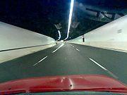
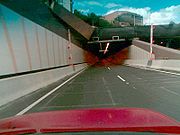
Lane Cove Tunnel
Encyclopedia

M2 Hills Motorway
The M2 Hills Motorway is a motorway in north-western Sydney, New South Wales, Australia. It forms part of Sydney Metroad 2 and the 110 km Sydney Orbital Network. West of Pennant Hills Road, the M2 is also part of the National Highway.-History:Previously, Sydney's western suburbs were poorly served...
at North Ryde with the Gore Hill Freeway
Gore Hill Freeway
The Gore Hill Freeway is a major freeway in Sydney, New South Wales, Australia. This freeway forms part of Metroad 1 andthe Sydney Orbital Network to provide access to most of the suburbs in Sydney and is also a major route to the north, south, east and west of the metropolis.It connects to the...
at Artarmon. It forms part of Sydney Metroad 2
Metroad 2
Metroad 2 is a Metroad in Sydney, New South Wales, Australia. It links Windsor to Artarmon.-Route Information:* Extremities: Lane Cove Tunnel at Artarmon to Windsor* Approximate length: 53 km...
and the 110 km Sydney Orbital Network. Connector Motorways
Connector Motorways
Connector Motorways is an Australian toll road operator. Connector owns the Lane Cove Tunnel and the Falcon Street Gateway in northern Sydney. Both projects opened to the public in March 2007....
was the owner and manager of the Lane Cove Tunnel and Falcon Street Gateway and were going to operate the tunnel concession until 2037. The "failed infrastructure project" has been a disaster for the company, which went into receivership in January 2010 after a string of losses. Transurban
Transurban
Transurban is an international toll road developer and manager with interests in Australia and North America. In Australia, Transurban has a stake in five out of Sydney’s nine motorways, and in Melbourne it is the full owner of CityLink, which connects three of the city’s major freeways...
, a company owning several other toll roads in Sydney
Sydney
Sydney is the most populous city in Australia and the state capital of New South Wales. Sydney is located on Australia's south-east coast of the Tasman Sea. As of June 2010, the greater metropolitan area had an approximate population of 4.6 million people...
purchased the tunnel in May, 2010 for $630 million and became the new operators of the tunnel. In 2008 tolls for the Lane Cove Tunnel were $2.62 for passenger vehicles and $5.24 for heavy vehicles, and are adjusted in line with the consumer price index
Consumer price index
A consumer price index measures changes in the price level of consumer goods and services purchased by households. The CPI, in the United States is defined by the Bureau of Labor Statistics as "a measure of the average change over time in the prices paid by urban consumers for a market basket of...
.
History
A joint venture between Thiess and John Holland was awarded the $1.1 billion contract by Connector Motorways to design and construct the tunnel. Previously, motorists had to drive along Epping RoadEpping Road
Epping Road , NSW Main Road 28, is an important arterial road in suburban Sydney. Epping Road is 9 kilometres long, and is a major route linking the lower North Shore and Sydney CBD to the north western suburbs and Hills District of metropolitan Sydney...
through the suburb of Lane Cove, for the few kilometres between the two freeway sections.
In the early hours of November 2, 2005 the roof area of a ventilation tunnel for the project collapsed. The roof collapse
caused the road above the area to subside, and damage a three storey building at 11-13 Longueville Road. The collapse caused a 10 metre by 10 metre crater to appear near the Pacific Highway's southbound exit ramp in Lane Cove, with forty seven people evacuated from the building. Emergency crews pumped 1000 cubic metres of concrete into the hole to try to stop the housing block from collapsing into it. An investigation by Workcover NSW found that the collapse was caused by geological conditions at the site, the large span width of the tunnel, and inadequacy of roof support. The proximity of the excavations to the surface resulted in the property damage.
The tunnel was opened by four workers, representing the 9,000 that worked on the Lane Cove Tunnel, Falcon Street Gateway and the widened Gore Hill Freeway Project on Sunday, March 25, 2007, two months ahead of schedule. The tunnel opened with a one-month toll-free period (as occurred with the Westlink M7).
Alternative routes
Before the opening of the tunnel, motorists had to drive along Epping Road through the suburb of Lane Cove, for the few kilometres between the two freeway sections. Studies by the tunnel operator shown that the Lane Cove Tunnel cuts travel times by up to 17 minutes and saves motorists over $4 a trip.With the completion of the surface road changes in March 2008, the existing Epping Road will have 24 hour bus lanes to reduce travel times for east and west bound bus services, a new bus interchange, a shared cyclist and pedestrian path and other measures to improve public transport and local traffic in in the corridor, while guiding traffic towards using the new tolled tunnel instead of the untolled surface road.
Falcon Street Gateway
The "Falcon Street Gateway" is a set of two north facing ramps on the Warringah Freeway providing access to and from Military Road. The toll costs $1.32 for passenger vehicles and $2.62 for heavy vehicles (southbound and northbound). Connector Motorways promotes that by using the new ramps, up to 19 sets of traffic lights can be avoided on the Pacific Highway. What they don't mention however is that traffic can still use the Warringah Freeway and take the North Sydney off-ramp, about 500m further on and not pay any toll for about a 1 minute extra journey. The Falcon Street Gateway is part of the larger project, including widening of the Gore Hill Freeway to improve traffic and provide greater connectivity to the lower North Shore, so the tolls collected at the Falcon Street Gateway fund also the expansion of the Gore Hill Freeway.Exits and Interchanges
| Lane Cove Tunnel |
|||
| Westbound exits | Distance to Windsor (km) |
Distance to Sydney (km) |
Eastbound exits |
| End Lane Cove Tunnel continues as Hills Motorway M2 Hills Motorway The M2 Hills Motorway is a motorway in north-western Sydney, New South Wales, Australia. It forms part of Sydney Metroad 2 and the 110 km Sydney Orbital Network. West of Pennant Hills Road, the M2 is also part of the National Highway.-History:Previously, Sydney's western suburbs were poorly served... to Epping Epping, New South Wales Epping is a suburb of Sydney, in the state of New South Wales, Australia. Epping is located 18 kilometres north-west of the Sydney central business district in the local government areas of the City of Ryde, the City of Parramatta and Hornsby Shire and is located in the Northern... / Windsor Windsor, New South Wales Windsor is a town in the state of New South Wales, Australia. Windsor is located in the local government area of the City of Hawkesbury. It sits on the Hawkesbury River, on the north-western outskirts of the Sydney metropolitan area. At the 2006 census, Windsor had a population of... |
42 | 14 | Start Lane Cove Tunnel from Hills Motorway M2 Hills Motorway The M2 Hills Motorway is a motorway in north-western Sydney, New South Wales, Australia. It forms part of Sydney Metroad 2 and the 110 km Sydney Orbital Network. West of Pennant Hills Road, the M2 is also part of the National Highway.-History:Previously, Sydney's western suburbs were poorly served... |
| Start Lane Cove Tunnel continues from Gore Hill Freeway Gore Hill Freeway The Gore Hill Freeway is a major freeway in Sydney, New South Wales, Australia. This freeway forms part of Metroad 1 andthe Sydney Orbital Network to provide access to most of the suburbs in Sydney and is also a major route to the north, south, east and west of the metropolis.It connects to the...  |
46 | 10 | Crows Nest Crows Nest, New South Wales Crows Nest is a suburb on the lower North Shore of Sydney, New South Wales, Australia. Crows Nest is located 5 kilometres north of the Sydney central business district, in the local government area of North Sydney Council.-History:... , Hornsby Hornsby, New South Wales * Highest Maximum Temperature: 42 °C* Lowest Maximum Temperature: 4.9 °C* Warmest Month: January* Coolest Month: July* Highest Precipitation: February* Lowest Precipitation: July-Notable residents:... Pacific Highway Pacific Highway (Australia) The Pacific Highway is a major transport route along part of the east coast of Australia and is part of Australia's national route 1.It is 960 km long and links Sydney, the capital of New South Wales, to Brisbane, the capital of Queensland, along the coast, via Gosford, Newcastle, Taree, Port... |
| End Lane Cove Tunnel continues as Gore Hill Freeway Gore Hill Freeway The Gore Hill Freeway is a major freeway in Sydney, New South Wales, Australia. This freeway forms part of Metroad 1 andthe Sydney Orbital Network to provide access to most of the suburbs in Sydney and is also a major route to the north, south, east and west of the metropolis.It connects to the... to Sydney Sydney Sydney is the most populous city in Australia and the state capital of New South Wales. Sydney is located on Australia's south-east coast of the Tasman Sea. As of June 2010, the greater metropolitan area had an approximate population of 4.6 million people... / Canberra Canberra Canberra is the capital city of Australia. With a population of over 345,000, it is Australia's largest inland city and the eighth-largest city overall. The city is located at the northern end of the Australian Capital Territory , south-west of Sydney, and north-east of Melbourne...  |
|||
Air quality
A report by CSIRO Deputy Chief of Air Science, Dr Peter Manins, concluded the ambient air quality modelling undertaken for Lane Cove Tunnel is 'best practice'. The air quality modelling shows that the Lane Cove Tunnel will comfortably meet the air quality requirements set by the Planning Minister's Conditions of Approval. Dr Manins also said most of the air quality modelling results are in fact likely to 'over estimate emission and pollution levels'.Ambient air quality is monitored at four monitoring stations nearby the tunnel's ventilation stacks. The monitoring results are published in real time on the operator's website.
The air quality readings published for particulate matter (PM10) are 24 hour averages as required by the Planning Minister's Conditions of Approval for the tunnel. Some commentators are concerned that averaging the readings over 24 hours offsets excedances of the 50uG goal which may occur during peak periods with lows which typically occur after midnight; effectively disguising short term excedances which may occur during peak periods.
2007 State election
The LaborAustralian Labor Party
The Australian Labor Party is an Australian political party. It has been the governing party of the Commonwealth of Australia since the 2007 federal election. Julia Gillard is the party's federal parliamentary leader and Prime Minister of Australia...
government has been accused of interfering in the tunnel project to increase its re-election chances in the March 2007 election
New South Wales legislative election, 2007
Elections for the 54th Parliament of New South Wales were held on Saturday, 24 March 2007. The entire Legislative Assembly and half of the Legislative Council was up for election. The Australian Labor Party led by Morris Iemma won a fourth four-year term against the Liberal-National coalition led...
. The tunnel's expected late-2006 opening was pushed back to "January or February", closer to the poll date. This time frame was missed and the opening was announced to be March 25, the day after the election.
In December 2006, it was announced that surface road changes would be delayed by five months, deferring them until after the state and federal elections. The delay, which will likely cut into tunnel revenues, was agreed to by the operators at a cost to taxpayers of $25 million.
The Sydney Morning Herald described the payment as a "bribe" and a "political rort". According to a Herald editorial, "The use of public funds to compensate Connector Motorways for delays to road changes around the tunnel is ... as cynical a piece of political jobbery as Sydney has seen in many a long year."
Changes to Epping Road http://www.connectormotorways.com.au/index.cfm?s=CAA6633E-3048-1075-63AF7C78202708AB&faq_cat=7D3E30D3-A50B-1000-138610ABEE82A21D
Changes made to Epping Road and associated roads included http://www.connectormotorways.com.au/index.cfm?s=CAA6633E-3048-1075-63AF7C78202708AB&faq_cat=7D3E30D3-A50B-1000-138610ABEE82A21D:(a) A bus interchange completed in March 2008 on the corner of Longueville Road and Parklands Avenue at Lane Cove.
(b) A new pedestrian overbridge across Longueville Road http://www.youtube.com/watch?v=T_mjp4W_4XU providing access to the bus interchange and a o the bus interchange and a link it to Lane Cove village.
(c) A new cycleway and pedestrian path http://www.bikenorth.org.au/webnews.php between Mowbray Road and Pacific Highway to join the completed cycleway between Mowbray and Wicks Road, North Ryde, and along the Gore Hill Freeway between Pacific Highway and Naremburn.
(d) As over 30 per cent of all travel on Epping Road is by public transport, bus-only lanes have been implemented http://www.transport.nsw.gov.au/news/Epping-Road-buses.pdf.
Some parts of Epping Road http://www.connectormotorways.com.au/index.cfm?s=CAA6633E-3048-1075-63AF7C78202708AB&faq_cat=7D3E30D3-A50B-1000-138610ABEE82A21D and Longueville Road required widening to provide the dedicated bus lanes and cycle path.
Epping Road eastbound http://www.connectormotorways.com.au/index.cfm?s=EDC17CC8-EB5A-126B-51EF14D8ED69BFAA - Between Mowbray Road west and Longueville Road http://www.connectormotorways.com.au/index.cfm?s=EDC17CC8-EB5A-126B-51EF14D8ED69BFAA, Lane Cove, has one general traffic lane and one bus lane eastbound.
Epping Road westbound - between Longueville Road and Centennial Avenue and between Sam Johnson Way and Mowbray Road West http://www.rta.nsw.gov.au/constructionmaintenance/majorconstructionprojectssydney/lanecovetunnel/maps/list2.html, has two general traffic lanes and one bus lane; between Centennial Avenue and Sam Johnson Way has one general traffic lane and one bus lane.
Right turn lanes have been reinstated for westbound traffic at Parklands Avenue and Centennial Avenue Lane Cove intersection. Street lighting has been upgraded. As the final construction activity, Epping Road between Mowbray Road and Pacific Highway has been resurfaced with new asphalt and new line marking.
These changes were considered in the 2001 Environmental Impact Statement (EIS) and are part of the Planning Minister's 2003 approval http://www.rta.nsw.gov.au/constructionmaintenance/majorconstructionprojectssydney/lanecovetunnel/approval_conditions.html. They have been supported by a more recent Parliamentary Inquiry http://www.parliament.nsw.gov.au/prod/parlment/committee.nsf/14842526706930f6ca2570de001f5c6a/162a7e8c1c07f531ca2571d300070643/$FILE/LCT%20Final%20compiled%20report%2017%20August.pdf.
The extensive community consultation http://www.parliament.nsw.gov.au/prod/parlment/committee.nsf/14842526706930f6ca2570de001f5c6a/162a7e8c1c07f531ca2571d300070643/$FILE/LCT%20Final%20compiled%20report%2017%20August.pdf was undertaken. A major component of this work is reconnecting the local community – reinstating right hand lanes, adding pedestrian crossings and making improvements to public transport infrastructure.