

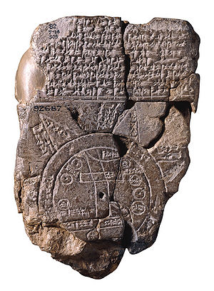
Babylonian Map of the World
Encyclopedia
Diagram
A diagram is a two-dimensional geometric symbolic representation of information according to some visualization technique. Sometimes, the technique uses a three-dimensional visualization which is then projected onto the two-dimensional surface...
matic label
Labeling (map design)
Cartographic labeling is a form of typography and strongly deals with form, style, weight and size of type on a map. Essentially, labeling denotes the correct way to label features .- Form :...
ed depiction of the known world from the perspective of Babylonia
Babylonia
Babylonia was an ancient cultural region in central-southern Mesopotamia , with Babylon as its capital. Babylonia emerged as a major power when Hammurabi Babylonia was an ancient cultural region in central-southern Mesopotamia (present-day Iraq), with Babylon as its capital. Babylonia emerged as...
. The map is incised on a clay tablet
Clay tablet
In the Ancient Near East, clay tablets were used as a writing medium, especially for writing in cuneiform, throughout the Bronze Age and well into the Iron Age....
, showing Babylon
Babylon
Babylon was an Akkadian city-state of ancient Mesopotamia, the remains of which are found in present-day Al Hillah, Babil Province, Iraq, about 85 kilometers south of Baghdad...
somewhat to the north of its center; the clay tablet is damaged, and also contains a section of cuneiform
Cuneiform
Cuneiform can refer to:*Cuneiform script, an ancient writing system originating in Mesopotamia in the 4th millennium BC*Cuneiform , three bones in the human foot*Cuneiform Records, a music record label...
text.
It is usually dated to the 6th century BC. It was discovered at Sippar
Sippar
Sippar was an ancient Near Eastern city on the east bank of the Euphrates river, located at the site of modern Tell Abu Habbah in Iraq's Babil Governorate, some 60 km north of Babylon and 30 km southeast of Baghdad....
, southern Iraq
Iraq
Iraq ; officially the Republic of Iraq is a country in Western Asia spanning most of the northwestern end of the Zagros mountain range, the eastern part of the Syrian Desert and the northern part of the Arabian Desert....
, 60 miles (97 km) north of Babylon
Babylon
Babylon was an Akkadian city-state of ancient Mesopotamia, the remains of which are found in present-day Al Hillah, Babil Province, Iraq, about 85 kilometers south of Baghdad...
on the east bank of the Euphrates River, and published in 1899.
The clay tablet resides at the British Museum
British Museum
The British Museum is a museum of human history and culture in London. Its collections, which number more than seven million objects, are amongst the largest and most comprehensive in the world and originate from all continents, illustrating and documenting the story of human culture from its...
(BM 92687).
It is conjectured that the island locations, though possibly referring to real areas, may also represent a mythological interpretation of the world.
Description of the mapped areas
The map is circular with two outer defined circles. CuneiformCuneiform
Cuneiform can refer to:*Cuneiform script, an ancient writing system originating in Mesopotamia in the 4th millennium BC*Cuneiform , three bones in the human foot*Cuneiform Records, a music record label...
script labels all locations inside the circular map, as well as a few regions outside. The two outer circles represent water in between and is labelled as "'river' of 'bitter' water", the salt sea.
Babylon
Babylon
Babylon was an Akkadian city-state of ancient Mesopotamia, the remains of which are found in present-day Al Hillah, Babil Province, Iraq, about 85 kilometers south of Baghdad...
is in the center of the map; parallel lines at the bottom seem to represent the southern marshes, and a curved line coming from the north, northeast appear to represent the Zagros Mountains
Zagros Mountains
The Zagros Mountains are the largest mountain range in Iran and Iraq. With a total length of 1,500 km , from northwestern Iran, and roughly correlating with Iran's western border, the Zagros range spans the whole length of the western and southwestern Iranian plateau and ends at the Strait of...
.
There are seven small interior circles at the perimeter areas within the circle, and they appear to represent seven cities.
Seven triangular sections on the external circle (water perimeter), represent named island
Island
An island or isle is any piece of sub-continental land that is surrounded by water. Very small islands such as emergent land features on atolls can be called islets, cays or keys. An island in a river or lake may be called an eyot , or holm...
s, but the damaged clay tablet has lost the three islands on the tablet's lower edge.
The three islands are named:
- island-"place of the rising sun"
- island-"the sun is hidden and nothing can be seen"
- island-"beyond the flight of birds"
- Note: In Behistun InscriptionBehistun InscriptionThe Behistun Inscription The Behistun Inscription The Behistun Inscription (also Bistun or Bisutun, Modern Persian: بیستون The Behistun Inscription (also Bistun or Bisutun, Modern Persian: بیستون...
Babylonian UrartuUrartuUrartu , corresponding to Ararat or Kingdom of Van was an Iron Age kingdom centered around Lake Van in the Armenian Highland....
is the same as in Persian ArmeniaArmeniaArmenia , officially the Republic of Armenia , is a landlocked mountainous country in the Caucasus region of Eurasia...
.
| align="center" width="40%"|
| align="left" width="22%"|1. "Mountain"
2. "City"
3. Urartu
Urartu
Urartu , corresponding to Ararat or Kingdom of Van was an Iron Age kingdom centered around Lake Van in the Armenian Highland....
4. Assyria
Assyria
Assyria was a Semitic Akkadian kingdom, extant as a nation state from the mid–23rd century BC to 608 BC centred on the Upper Tigris river, in northern Mesopotamia , that came to rule regional empires a number of times through history. It was named for its original capital, the ancient city of Assur...
5. Der
6. ?
7. Swamp
8. Elam
Elam
Elam was an ancient civilization located in what is now southwest Iran. Elam was centered in the far west and the southwest of modern-day Iran, stretching from the lowlands of Khuzestan and Ilam Province, as well as a small part of southern Iraq...
9. Canal
10. Bit Yakin
| align="left"|11. "City"
12. Habban
13. Babylon
Babylon
Babylon was an Akkadian city-state of ancient Mesopotamia, the remains of which are found in present-day Al Hillah, Babil Province, Iraq, about 85 kilometers south of Baghdad...
, divided by Euphrates
Euphrates
The Euphrates is the longest and one of the most historically important rivers of Western Asia. Together with the Tigris, it is one of the two defining rivers of Mesopotamia...
14 — 17. Ocean (salt water)
18 — 22. Mythological objects
|}>