
Caprock Canyons State Park and Trailway
Encyclopedia
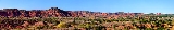
Caprock Canyons State Park and Trailway is a Texas
state park
on the Caprock Escarpment
in Briscoe County, Texas, United States
, approximately 100 miles (160.9 km) southeast of Amarillo
. The state park opened in 1982 and is 15313.6 acres (6,197.2 ha) in size, making it the third-largest state park in Texas.
opened that stretches through the park through Floyd, Briscoe, and Hall counties. The trailway was created after the Texas Parks and Wildlife Department acquired 64.25 miles (103 km) of right-of-way
from the abandoned Fort Worth and Denver Railroad
's lines between Estelline
and the South Plains
.
and has a semi-arid climate. The average January minimum temperature is 19 °F (-7.2 °C) and the average July maximum is 91 °F (32.8 °C). The park receives 20.4 inches (518.2 mm) of precipitation annually.
with mesquite
, cacti
and juniper
s with tall grass
es, plum
s, hackberries and cottonwoods in the canyons.
African aouodad sheep
(barbary sheep), mule deer
, white-tailed deer
, coyote
s, opossums, raccoon
s, bobcat
s, fox
es, porcupine
s, numerous species of snakes and lizards, and over 175 species of birds including Golden Eagle
s are found within the park. Caprock Canyons State Park and Trailway is the home of the official Texas State Bison
Herd. Lake Theo contains bass
and catfish
.
Texas
Texas is the second largest U.S. state by both area and population, and the largest state by area in the contiguous United States.The name, based on the Caddo word "Tejas" meaning "friends" or "allies", was applied by the Spanish to the Caddo themselves and to the region of their settlement in...
state park
State park
State parks are parks or other protected areas managed at the federated state level within those nations which use "state" as a political subdivision. State parks are typically established by a state to preserve a location on account of its natural beauty, historic interest, or recreational...
on the Caprock Escarpment
Caprock Escarpment
The Caprock Escarpment is a term used in Texas and Eastern New Mexico to describe the geographical transition point between the level elevated plains of the Llano Estacado and the surrounding rolling terrain. In Texas, the escarpment stretches around 320 km south-southwest from the northeast...
in Briscoe County, Texas, United States
United States
The United States of America is a federal constitutional republic comprising fifty states and a federal district...
, approximately 100 miles (160.9 km) southeast of Amarillo
Amarillo, Texas
Amarillo is the 14th-largest city, by population, in the state of Texas, the largest in the Texas Panhandle, and the seat of Potter County. A portion of the city extends into Randall County. The population was 190,695 at the 2010 census...
. The state park opened in 1982 and is 15313.6 acres (6,197.2 ha) in size, making it the third-largest state park in Texas.
Trailway
In 1993, a hiking, biking, and equestrian rail trailRail trail
A rail trail is the conversion of a disused railway easement into a multi-use path, typically for walking, cycling and sometimes horse riding. The characteristics of former tracks—flat, long, frequently running through historical areas—are appealing for various development. The term sometimes also...
opened that stretches through the park through Floyd, Briscoe, and Hall counties. The trailway was created after the Texas Parks and Wildlife Department acquired 64.25 miles (103 km) of right-of-way
Right-of-way (railroad)
A right-of-way is a strip of land that is granted, through an easement or other mechanism, for transportation purposes, such as for a trail, driveway, rail line or highway. A right-of-way is reserved for the purposes of maintenance or expansion of existing services with the right-of-way...
from the abandoned Fort Worth and Denver Railroad
Fort Worth and Denver Railway
The Fort Worth and Denver Railway , nicknamed "the Denver Road," was a class I American railroad company that operated in the northern part of Texas from 1881 to 1982, and had a profound influence on the early settlement and economic development of the region....
's lines between Estelline
Estelline, Texas
Estelline is a town in Hall County, Texas, United States. The population was 168 at the 2000 census. A July 1, 2008 U.S. Census Bureau estimate placed the population at 155.-Geography:...
and the South Plains
South Plains
South Plains is a vernacular term that refers to a region in West Texas consisting of the portion of the Llano Estacado extending south of the Texas Panhandle, centered at Lubbock. While prominent in the area of petroleum production, the South Plains is mainly an agricultural region, producing a...
.
Climate
The park is located in West TexasWest Texas
West Texas is a vernacular term applied to a region in the southwestern quadrant of the United States that primarily encompasses the arid and semi-arid lands in the western portion of the state of Texas....
and has a semi-arid climate. The average January minimum temperature is 19 °F (-7.2 °C) and the average July maximum is 91 °F (32.8 °C). The park receives 20.4 inches (518.2 mm) of precipitation annually.
Flora and fauna
The area contains badlandsBadlands
A badlands is a type of dry terrain where softer sedimentary rocks and clay-rich soils have been extensively eroded by wind and water. It can resemble malpaís, a terrain of volcanic rock. Canyons, ravines, gullies, hoodoos and other such geological forms are common in badlands. They are often...
with mesquite
Mesquite
Mesquite is a leguminous plant of the Prosopis genus found in northern Mexico through the Sonoran Desert and Chihuahuan Deserts, and up into the Southwestern United States as far north as southern Kansas, west to the Colorado Desert in California,and east to the eastern fifth of Texas, where...
, cacti
Cactus
A cactus is a member of the plant family Cactaceae. Their distinctive appearance is a result of adaptations to conserve water in dry and/or hot environments. In most species, the stem has evolved to become photosynthetic and succulent, while the leaves have evolved into spines...
and juniper
Juniper
Junipers are coniferous plants in the genus Juniperus of the cypress family Cupressaceae. Depending on taxonomic viewpoint, there are between 50-67 species of juniper, widely distributed throughout the northern hemisphere, from the Arctic, south to tropical Africa in the Old World, and to the...
s with tall grass
Grass
Grasses, or more technically graminoids, are monocotyledonous, usually herbaceous plants with narrow leaves growing from the base. They include the "true grasses", of the Poaceae family, as well as the sedges and the rushes . The true grasses include cereals, bamboo and the grasses of lawns ...
es, plum
Plum
A plum or gage is a stone fruit tree in the genus Prunus, subgenus Prunus. The subgenus is distinguished from other subgenera in the shoots having a terminal bud and solitary side buds , the flowers in groups of one to five together on short stems, and the fruit having a groove running down one...
s, hackberries and cottonwoods in the canyons.
African aouodad sheep
Barbary sheep
The Barbary Sheep is a species of caprid native to rocky mountains in North Africa. Six subspecies have been described. Although it is rare in its native North Africa, it has been introduced to North America, southern Europe and elsewhere...
(barbary sheep), mule deer
Mule Deer
The mule deer is a deer indigenous to western North America. The Mule Deer gets its name from its large mule-like ears. There are believed to be several subspecies, including the black-tailed deer...
, white-tailed deer
White-tailed Deer
The white-tailed deer , also known as the Virginia deer or simply as the whitetail, is a medium-sized deer native to the United States , Canada, Mexico, Central America, and South America as far south as Peru...
, coyote
Coyote
The coyote , also known as the American jackal or the prairie wolf, is a species of canine found throughout North and Central America, ranging from Panama in the south, north through Mexico, the United States and Canada...
s, opossums, raccoon
Raccoon
Procyon is a genus of nocturnal mammals, comprising three species commonly known as raccoons, in the family Procyonidae. The most familiar species, the common raccoon , is often known simply as "the" raccoon, as the two other raccoon species in the genus are native only to the tropics and are...
s, bobcat
Bobcat
The bobcat is a North American mammal of the cat family Felidae, appearing during the Irvingtonian stage of around 1.8 million years ago . With twelve recognized subspecies, it ranges from southern Canada to northern Mexico, including most of the continental United States...
s, fox
Fox
Fox is a common name for many species of omnivorous mammals belonging to the Canidae family. Foxes are small to medium-sized canids , characterized by possessing a long narrow snout, and a bushy tail .Members of about 37 species are referred to as foxes, of which only 12 species actually belong to...
es, porcupine
Porcupine
Porcupines are rodents with a coat of sharp spines, or quills, that defend or camouflage them from predators. They are indigenous to the Americas, southern Asia, and Africa. Porcupines are the third largest of the rodents, behind the capybara and the beaver. Most porcupines are about long, with...
s, numerous species of snakes and lizards, and over 175 species of birds including Golden Eagle
Golden Eagle
The Golden Eagle is one of the best known birds of prey in the Northern Hemisphere. Like all eagles, it belongs to the family Accipitridae. Once widespread across the Holarctic, it has disappeared from many of the more heavily populated areas...
s are found within the park. Caprock Canyons State Park and Trailway is the home of the official Texas State Bison
American Bison
The American bison , also commonly known as the American buffalo, is a North American species of bison that once roamed the grasslands of North America in massive herds...
Herd. Lake Theo contains bass
Bass (fish)
Bass is a name shared by many different species of popular gamefish. The term encompasses both freshwater and marine species. All belong to the large order Perciformes, or perch-like fishes, and in fact the word bass comes from Middle English bars, meaning "perch."-Types of basses:*The temperate...
and catfish
Catfish
Catfishes are a diverse group of ray-finned fish. Named for their prominent barbels, which resemble a cat's whiskers, catfish range in size and behavior from the heaviest and longest, the Mekong giant catfish from Southeast Asia and the second longest, the wels catfish of Eurasia, to detritivores...
.
See also
- Yellow House CanyonYellow House CanyonYellow House Canyon is a canyon that is about long, heading in Lubbock, Texas, at the junction of Blackwater Draw and Yellow House Draw, and trending generally southeastward to the edge of the Llano Estacado about east of Slaton, Texas; it forms one of three major canyons along the east side of...
- Palo Duro CanyonPalo Duro CanyonPalo Duro Canyon is a canyon system of the Caprock Escarpment located in the Texas Panhandle near the city of Amarillo, Texas, United States. As the second largest canyon in the United States, it is roughly long and has an average width of , but reaches a width of at places. Its depth is around...
- Blanco CanyonBlanco CanyonBlanco Canyon is a canyon located in the U.S. state of Texas. Eroded by the White River into the Caprock Escarpment on the east side of the Llano Estacado, the canyon runs for in a southeasterly direction, gradually widening from its beginning in southwestern Floyd County to across at its mouth...
- Mount BlancoMount BlancoMount Blanco is a small white hill — an erosional remnant — located on the eastern border of the Llano Estacado within Blanco Canyon in Crosby County, Texas...
- Caprock EscarpmentCaprock EscarpmentThe Caprock Escarpment is a term used in Texas and Eastern New Mexico to describe the geographical transition point between the level elevated plains of the Llano Estacado and the surrounding rolling terrain. In Texas, the escarpment stretches around 320 km south-southwest from the northeast...
- Mescalero EscarpmentMescalero EscarpmentThe Mescalero Escarpment, also known as the Mescalero Ridge, forms the western edge of the great Llano Estacado, a vast plateau or tableland in the southwestern United States in New Mexico and Texas...
External links
- Caprock Canyons State Park and Trailway from Texas Parks and Wildlife (TPWD)
- Facilities and Fee Information from TPWD
- Caprock Canyons Facility Map (PDFPortable Document FormatPortable Document Format is an open standard for document exchange. This file format, created by Adobe Systems in 1993, is used for representing documents in a manner independent of application software, hardware, and operating systems....
) from TPWD - Caprock Canyons Trailway Map and Guide (PDFPortable Document FormatPortable Document Format is an open standard for document exchange. This file format, created by Adobe Systems in 1993, is used for representing documents in a manner independent of application software, hardware, and operating systems....
) from TPWD