
Caprock Escarpment
Encyclopedia
The Caprock Escarpment is a term used in Texas
and Eastern New Mexico
to describe the geographical transition point between the level elevated plains
of the Llano Estacado
and the surrounding rolling terrain. In Texas, the escarpment stretches around 320 km (200 mi) south-southwest from the northeast corner of the Texas Panhandle
near the Oklahoma
border. The escarpment is especially notable in Borden
, Briscoe, Crosby, Dickens, Floyd, and Motley counties. In New Mexico, there is a prominent escarpment along the northernmost extension of the Llano Estacado
, especially to the south of San Jon
and Tucumcari
, both in Quay County, New Mexico
. Along the western edge of the Llano Estacado
, the portion of the escarpment that stretches from Caprock, New Mexico
to Maljamar, New Mexico
is called the Mescalero Escarpment
.
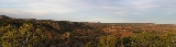
— a layer of calcium carbonate
that resists erosion very well. In some places, the escarpment rises around 305 m (1,000 ft) above the plains to the east. The escarpment's features formed by erosion from rivers and streams, creating arroyos
and highly diverse terrain, including the large Palo Duro Canyon
southeast of Amarillo, Texas
.
is located near Quitaque
and opened in 1982. A large, 105 km (65 mi) trail was developed within the park in 1992. Along the trail is Clarity Tunnel, home to a large colony of Free-tailed Bat
s.
Texas
Texas is the second largest U.S. state by both area and population, and the largest state by area in the contiguous United States.The name, based on the Caddo word "Tejas" meaning "friends" or "allies", was applied by the Spanish to the Caddo themselves and to the region of their settlement in...
and Eastern New Mexico
Eastern New Mexico
Eastern New Mexico is a region of the U.S. state of New Mexico. The region is sometimes termed the "High Plains" or even "Little Texas". The region is largely coterminous with the Llano Estacado. Eastern New Mexico is generally located at an altitude of over 4,000 feet and is mostly characterized...
to describe the geographical transition point between the level elevated plains
High Plains (United States)
The High Plains are a subregion of the Great Plains mostly in the Western United States, but also partly in the Midwest states of Nebraska, Kansas, and South Dakota, generally encompassing the western part of the Great Plains before the region reaches the Rocky Mountains...
of the Llano Estacado
Llano Estacado
Llano Estacado , commonly known as the Staked Plains, is a region in the Southwestern United States that encompasses parts of eastern New Mexico and northwestern Texas, including the South Plains and parts of the Texas Panhandle...
and the surrounding rolling terrain. In Texas, the escarpment stretches around 320 km (200 mi) south-southwest from the northeast corner of the Texas Panhandle
Texas Panhandle
The Texas Panhandle is a region of the U.S. state of Texas consisting of the northernmost 26 counties in the state. The panhandle is a rectangular area bordered by New Mexico to the west and Oklahoma to the north and east...
near the Oklahoma
Oklahoma
Oklahoma is a state located in the South Central region of the United States of America. With an estimated 3,751,351 residents as of the 2010 census and a land area of 68,667 square miles , Oklahoma is the 28th most populous and 20th-largest state...
border. The escarpment is especially notable in Borden
Borden County, Texas
Borden County is a rural county located in the U.S. state of Texas. In 2000, its population was 729. Its county seat is Gail. Gail and Borden County are named for Gail Borden, Jr., businessman, publisher, surveyor, and inventor of condensed milk...
, Briscoe, Crosby, Dickens, Floyd, and Motley counties. In New Mexico, there is a prominent escarpment along the northernmost extension of the Llano Estacado
Llano Estacado
Llano Estacado , commonly known as the Staked Plains, is a region in the Southwestern United States that encompasses parts of eastern New Mexico and northwestern Texas, including the South Plains and parts of the Texas Panhandle...
, especially to the south of San Jon
San Jon, New Mexico
San Jon is a village in Quay County, New Mexico, United States. The population was 306 at the 2000 census.- History :The village was founded in 1902 and grew after the arrival of the railroad in 1904. It was once an important local commercial center and stop on U.S. Route 66 and home to numerous...
and Tucumcari
Tucumcari, New Mexico
Tucumcari is a city in and the county seat of Quay County, New Mexico, United States. The population was 5,989 at the 2000 census. Tucumcari was founded in 1901, two years before Quay County was founded.-History:...
, both in Quay County, New Mexico
Quay County, New Mexico
-2010:Whereas according to the 2010 U.S. Census Bureau:*86.1% White*1.1% Black*1.2% Native American*1.0% Asian*0.0% Native Hawaiian or Pacific Islander*3.4% Two or more races*7.2% Other races*42.4% Hispanic or Latino -2000:...
. Along the western edge of the Llano Estacado
Llano Estacado
Llano Estacado , commonly known as the Staked Plains, is a region in the Southwestern United States that encompasses parts of eastern New Mexico and northwestern Texas, including the South Plains and parts of the Texas Panhandle...
, the portion of the escarpment that stretches from Caprock, New Mexico
Caprock, New Mexico
Caprock is an unincorporated town in Lea County, New Mexico, United States.-References:...
to Maljamar, New Mexico
Maljamar, New Mexico
Maljamar is an unincorporated town in Lea County, New Mexico, United States. The zip code is 88264. It is close to Hobbs and Carlsbad.According to legend, Maljamar's founder William Mitchell named the town after his three children Malcom, Janet and Margaret...
is called the Mescalero Escarpment
Mescalero Escarpment
The Mescalero Escarpment, also known as the Mescalero Ridge, forms the western edge of the great Llano Estacado, a vast plateau or tableland in the southwestern United States in New Mexico and Texas...
.
Description
The escarpment is made of CalicheCaliche (Mineral)
Caliche is a sedimentary rock, a hardened deposit of calcium carbonate. This calcium carbonate cements together other materials, including gravel, sand, clay, and silt. It is found in aridisol and mollisol soil orders...
— a layer of calcium carbonate
Calcium carbonate
Calcium carbonate is a chemical compound with the formula CaCO3. It is a common substance found in rocks in all parts of the world, and is the main component of shells of marine organisms, snails, coal balls, pearls, and eggshells. Calcium carbonate is the active ingredient in agricultural lime,...
that resists erosion very well. In some places, the escarpment rises around 305 m (1,000 ft) above the plains to the east. The escarpment's features formed by erosion from rivers and streams, creating arroyos
Arroyo (creek)
An arroyo , a Spanish word translated as brook, and also called a wash is usually a dry creek or stream bed—gulch that temporarily or seasonally fills and flows after sufficient rain. Wadi is a similar term in Africa. In Spain, a rambla has a similar meaning to arroyo.-Types and processes:Arroyos...
and highly diverse terrain, including the large Palo Duro Canyon
Palo Duro Canyon
Palo Duro Canyon is a canyon system of the Caprock Escarpment located in the Texas Panhandle near the city of Amarillo, Texas, United States. As the second largest canyon in the United States, it is roughly long and has an average width of , but reaches a width of at places. Its depth is around...
southeast of Amarillo, Texas
Amarillo, Texas
Amarillo is the 14th-largest city, by population, in the state of Texas, the largest in the Texas Panhandle, and the seat of Potter County. A portion of the city extends into Randall County. The population was 190,695 at the 2010 census...
.
Parks
The Caprock Canyons State Park and TrailwayCaprock Canyons State Park and Trailway
Caprock Canyons State Park and Trailway is a Texas state park on the Caprock Escarpment in Briscoe County, Texas, United States, approximately southeast of Amarillo...
is located near Quitaque
Quitaque, Texas
Quitaque is a city in Briscoe County, Texas, United States. The population was 432 at the 2000 census.The Texas high school football and college coach Gene Mayfield was born in Quitaque in 1928.-Geography:Quitaque is located at ....
and opened in 1982. A large, 105 km (65 mi) trail was developed within the park in 1992. Along the trail is Clarity Tunnel, home to a large colony of Free-tailed Bat
Free-tailed bat
Molossidae, or free-tailed bats, are a family of bats within the order Chiroptera. They are generally quite robust, and consist of many strong flying forms with relatively long and narrow wings. Another common name for some members of this group, and indeed a few species from other families, is...
s.
See also
- List of geographical regions in Texas
- Yellow House CanyonYellow House CanyonYellow House Canyon is a canyon that is about long, heading in Lubbock, Texas, at the junction of Blackwater Draw and Yellow House Draw, and trending generally southeastward to the edge of the Llano Estacado about east of Slaton, Texas; it forms one of three major canyons along the east side of...
- Palo Duro CanyonPalo Duro CanyonPalo Duro Canyon is a canyon system of the Caprock Escarpment located in the Texas Panhandle near the city of Amarillo, Texas, United States. As the second largest canyon in the United States, it is roughly long and has an average width of , but reaches a width of at places. Its depth is around...
- Caprock CanyonsCaprock Canyons State Park and TrailwayCaprock Canyons State Park and Trailway is a Texas state park on the Caprock Escarpment in Briscoe County, Texas, United States, approximately southeast of Amarillo...
- Double Mountain Fork Brazos RiverDouble Mountain Fork Brazos RiverThe Double Mountain Fork Brazos River is an ephemeral, sandy-braided stream about long, heading on the Llano Estacado of West Texas about southeast of Tahoka, Texas, flowing east-northeast across the western Rolling Plains to join the Salt Fork, forming the Brazos River about west-northwest of...
- Prairie Dog Town Fork Red RiverPrairie Dog Town Fork Red RiverPrairie Dog Town Fork Red River is a sandy-braided stream about long, formed at the confluence of Palo Duro Creek and Tierra Blanca Creek, about northeast of Canyon in Randall County, Texas, and flowing east-southeastward to the Red River about east of the 100th meridian, south-southwest of...
- Mount BlancoMount BlancoMount Blanco is a small white hill — an erosional remnant — located on the eastern border of the Llano Estacado within Blanco Canyon in Crosby County, Texas...