

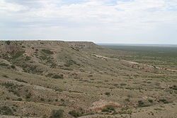
Mescalero Escarpment
Encyclopedia

Llano Estacado
Llano Estacado , commonly known as the Staked Plains, is a region in the Southwestern United States that encompasses parts of eastern New Mexico and northwestern Texas, including the South Plains and parts of the Texas Panhandle...
, a vast plateau
Plateau
In geology and earth science, a plateau , also called a high plain or tableland, is an area of highland, usually consisting of relatively flat terrain. A highly eroded plateau is called a dissected plateau...
or tableland in the southwestern United States
United States
The United States of America is a federal constitutional republic comprising fifty states and a federal district...
in New Mexico
New Mexico
New Mexico is a state located in the southwest and western regions of the United States. New Mexico is also usually considered one of the Mountain States. With a population density of 16 per square mile, New Mexico is the sixth-most sparsely inhabited U.S...
and Texas
Texas
Texas is the second largest U.S. state by both area and population, and the largest state by area in the contiguous United States.The name, based on the Caddo word "Tejas" meaning "friends" or "allies", was applied by the Spanish to the Caddo themselves and to the region of their settlement in...
. It is an extension of the Caprock Escarpment
Caprock Escarpment
The Caprock Escarpment is a term used in Texas and Eastern New Mexico to describe the geographical transition point between the level elevated plains of the Llano Estacado and the surrounding rolling terrain. In Texas, the escarpment stretches around 320 km south-southwest from the northeast...
.
Mescalero Sands
Extending north south along the western edge of the Mescalero Escarpment lies a vast sand sheet called the Mescalero Sands, named for the Mescalero ApachesMescalero
Mescalero is an Apache tribe of Southern Athabaskan Native Americans. The tribe is federally recognized as the Mescalero Apache Tribe of the Mescalero Apache Reservation in southcentral New Mexico...
who once hunted in these sandhills. In 1928, Nelson Horatio Darton
Nelson Horatio Darton
Nelson Horatio Darton was a geologist who worked for the United States Geological Survey. He was born in Brooklyn, New York, and started working in his uncle's drug business at the age of 13, also becoming a practicing chemist. His interest in geology started as a sideline, and he was hired by...
of the United States Geological Survey
United States Geological Survey
The United States Geological Survey is a scientific agency of the United States government. The scientists of the USGS study the landscape of the United States, its natural resources, and the natural hazards that threaten it. The organization has four major science disciplines, concerning biology,...
observed: “On the east side of the Pecos Valley
Pecos River
The headwaters of the Pecos River are located north of Pecos, New Mexico, United States, at an elevation of over 12,000 feet on the western slope of the Sangre de Cristo mountain range in Mora County. The river flows for through the eastern portion of that state and neighboring Texas before it...
in southern New Mexico
New Mexico
New Mexico is a state located in the southwest and western regions of the United States. New Mexico is also usually considered one of the Mountain States. With a population density of 16 per square mile, New Mexico is the sixth-most sparsely inhabited U.S...
there are very extensive sand hills
Sandhill
A sandhill is a type of ecological community or xeric wildfire-maintained ecosystem. It is not the same as a sand dune. It features very short fire return intervals, one to five years. Without fire, sandhills undergo ecological succession and become more oak dominated.Entisols are the typical...
formed of deposits known as the ‘Mescalero Sands,’ which are doubtless of Quaternary
Quaternary
The Quaternary Period is the most recent of the three periods of the Cenozoic Era in the geologic time scale of the ICS. It follows the Neogene Period, spanning 2.588 ± 0.005 million years ago to the present...
age ...” In places, these sands climb up and over the Mescalero Escarpment and spread out over portions of the Llano Estacado
Llano Estacado
Llano Estacado , commonly known as the Staked Plains, is a region in the Southwestern United States that encompasses parts of eastern New Mexico and northwestern Texas, including the South Plains and parts of the Texas Panhandle...
.
See also
- Llano EstacadoLlano EstacadoLlano Estacado , commonly known as the Staked Plains, is a region in the Southwestern United States that encompasses parts of eastern New Mexico and northwestern Texas, including the South Plains and parts of the Texas Panhandle...
- Palo Duro CanyonPalo Duro CanyonPalo Duro Canyon is a canyon system of the Caprock Escarpment located in the Texas Panhandle near the city of Amarillo, Texas, United States. As the second largest canyon in the United States, it is roughly long and has an average width of , but reaches a width of at places. Its depth is around...
- Caprock CanyonsCaprock Canyons State Park and TrailwayCaprock Canyons State Park and Trailway is a Texas state park on the Caprock Escarpment in Briscoe County, Texas, United States, approximately southeast of Amarillo...
- Mount BlancoMount BlancoMount Blanco is a small white hill — an erosional remnant — located on the eastern border of the Llano Estacado within Blanco Canyon in Crosby County, Texas...
- List of geographical regions in Texas
- Geology of TexasGeology of TexasTexas contains a great variety of geologic settings. The state's stratigraphy has been largely influenced by marine transgressive-regressive cycles during the Phanerozoic, with a lesser but still significant contribution from late Cenozoic tectonic activity, as well as the remnants of a Paleozoic...