
Cape Hatteras Light
Encyclopedia
Cape Hatteras Light is a lighthouse
located on Hatteras Island
in the Outer Banks
of North Carolina
near the community of Buxton
, and is part of the Cape Hatteras National Seashore
.
The Outer Banks are a group of islands on the North Carolina coast that separate the Atlantic Ocean
from the coastal sounds and inlets. Atlantic currents
in this area made for excellent travel for ships, except in the area of Diamond Shoals, just offshore at Cape Hatteras
. Nearby, the warm Gulf Stream
ocean current collides with the colder Labrador Current
, creating ideal conditions for powerful ocean storms and sea swells. The large number of ships that ran aground because of these shifting sandbars, including the Civil War
ironclad
warship
USS Monitor
, gave this area the nickname “Graveyard of the Atlantic
.” It also led Congress to authorize the construction of the Cape Hatteras Lighthouse which is recognized by the National Park Service
as the tallest lighthouse
in America
.
The lighthouse is one of several on the North Carolina coast that are still operational including the Currituck
, Bodie Island, Ocracoke, Cape Lookout
, and Oak Island
lighthouses.
At a height of 200 feet (61 m) it is the 23rd tallest traditional lighthouse in the world.
The Cape Hatteras lighthouse is still considered an operational aid to navigation maintained by the United States Coast Guard
and the National Park Service
. However, the need for the lighthouse has been reduced by modern day GPS and other electronic navigational devices.
The lighthouse beacon was also augmented by the 175 feet (53.3 m) tall Diamond Shoals light tower, which is 12 miles (19.3 km) off of the Hatteras coast. The light tower was put in place in 1967 and lightships
were present before then dating back to 1824, including one lightship sunk by a German
submarine
during World War I
. The light tower has recently been decommissioned by the United States Coast Guard, as maintenance on the structure proved too expensive in light of increasing reliance on GPS.
The National Park
permits climbing to the top of the lighthouse. For a number of years, this was not possible due to repairs to the lighthouse. The lighthouse is open for tours from the third Friday in April to Columbus Day. The climb is considered strenuous because it is equivalent to 12 stories. There is a handrail on only one side of the stairs, and there is two-way traffic on the stairs.
, which is located in the historic Cape Hatteras Lighthouse Double Keepers' Quarters. Exhibits include the history, maritime heritage and natural history of the Outer Banks and the lighthouse. The visitor center offers information about the Cape Hatteras National Seashore
, ranger programs and a bookstore.
The Cape Hatteras light marked very dangerous shoals which extend from the cape for a distance of 10 nautical miles (18.5 km). The original tower was built of dark sandstone and retained its natural color. The original light consisted of 18 lamps; with 14 inches (355.6 mm) reflectors, and was 112 feet (34.1 m) above sea level. It was visible in clear weather for a distance of 18 miles (29 km).
In July 1851, Lt. David D. Porter, USN, reported as follows:
The improvement in the light referred to had begun in 1845 when the reflectors were changed from 14 to 15 inches (381 mm). In 1848 the 18 lamps were changed to 15 lamps with 21 inches (533.4 mm) reflectors and the light had become visible in clear weather at a distance of 20 miles (32.2 km). In 1854 a first-order Fresnel lens with flashing white light was substituted for the old reflecting apparatus, and the tower was raised to 150 feet (45.7 m).
In 1860 the Lighthouse Board reported that Cape Hatteras Lighthouse required protection, due to the outbreak of the Civil War. In 1862 the Board reported "Cape Hatteras, lens and lantern destroyed, light reexhibited."
 At the behest of mariners and officers of the U.S. Navy, Congress appropriated $80,000 to the United States Lighthouse Board
to construct a new beacon at Cape Hatteras in 1868. The Light-House Board was a federal agency under the direction of the Treasury Department but was headed by a multi-agency committee. The Board consisted of two Army Engineers, two Navy officers, two civilian scientists, and one additional officer from both the Army and Navy to serve as secretaries. Congress established the Board in 1852 for the purpose of creating a unified, continuous system of navigational aides along the coasts. Prior to 1852, lighthouse construction generally rested with local authorities, ultimately leading to a disjointed, ineffective national system. Under the Light-House Board, Navy officers determined where new lighthouses were needed; Army Engineers selected exact locations, designed, and built them; and civilian scientists developed new technologies and techniques for displaying bright, consistent beacons.
Completed in just under two years under the direction of brevet
Brigadier General
J. H. Simpson of the U.S. Army Corps of Engineers, the new Cape Hatteras lighthouse cost $167,000. The new tower, from which the first-order light was first exhibited December 16, 1871, was the highest brick lighthouse tower in the world. It was 193 feet (58.8 m) above ground and the focal height of the light was 191 feet (58.2 m) above water. The old tower "being no longer of any use and in danger of falling during some heavy storm" was demolished in February 1872.
In the spring of 1879 the tower was struck by lightning. Cracks subsequently appeared in the masonry walls, which was remedied by placing a metal rod to connect the iron work of the tower with an iron disk sunk in the ground. In 1912 the candlepower of the light was increased from 27,000 to 80,000.
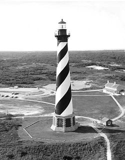 Ever since the completion of the new tower in 1870, there had begun a very gradual encroachment of the sea upon the beach. This did not become serious, however, until 1919, when the high water line had advanced to about 300 feet (91.4 m) from the base of the tower. Since that time the surf gnawed steadily toward the base of the tower until 1935, when the site was finally reached by the surf. Several attempts were made to arrest this erosion, but dikes and breakwaters had been of no avail. In 1935, therefore, the tower light was replaced by a light on a skeleton steel tower placed farther back from the sea on a sand dune, 166 feet (50.6 m) above the sea, and visible for 19 miles (30.6 km). The old tower was then abandoned to the custody of the National Park Service.
The Civilian Conservation Corps
and Works Progress Administration
erected a series of wooden revetments which checked the wash that was carrying away the beach. In 1942 the Coast Guard resumed its control over the tower, and manned it as a lookout station until 1945. The old tower was now 500 to 900 feet (274.3 m) inland from the sea and again tenable as a site for the light, which was placed in commission January 23, 1950.
The new light consists of a 36 inch (0.9144 m) aviation-type rotating beacon of 250,000 candlepower, visible 20 miles (32.2 km), and flashing white every 7.5 seconds. The skeleton steel tower was retained to guard against the time that the brick tower may again be endangered by erosion and thus require that the light again be moved.
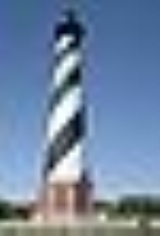
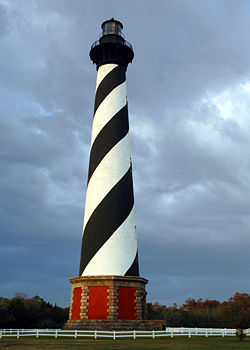
The light displays a highly visible black and white diagonal Daymark
paint job. It shares similar markings with the St. Augustine Light
. Another lighthouse, with helical markings—red and white 'candy cane
stripe
'-- is the White Shoal Light (Michigan)
, which is the only true 'barber pole' lighthouse in the United States. Its distinctive "barber pole" paint job is consistent with other North Carolina black-and-white lighthouses, "each with their own pattern to help sailors identify lighthouses during daylight hours."
The National Park Service acquired ownership of the lighthouse when it was abandoned in 1935. In 1950, when the structure was again found safe for use, new lighting equipment was installed. Now the Coast Guard owns and operates the navigational equipment, while the National Park Service maintains the tower as a historic structure. The Hatteras Island Visitor Center, formerly the Double Keepers Quarters located next to the lighthouse, elaborates on the Cape Hatteras story and man's lifestyle on the Outer Banks. Cape Hatteras Lighthouse, tallest in the United States, stands 208 feet (63.4 m) from the bottom of the foundation to the peak of the roof. To reach the light, which shines 191 feet (58.2 m) above mean high water mark, a Coast Guardsman must climb 268 steps. The construction order of 1,250,000 bricks was used in construction of the lighthouse and principal keeper's quarters.
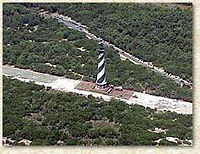
 Due to erosion
of the shore, the Cape Hatteras lighthouse was moved from its original location at the edge of the ocean to safer ground 2870 feet (874.8 m) inland. International Chimney Corp. of Buffalo, New York was awarded the contract to move the lighthouse, assisted, among other contractors, by Expert House Movers of Maryland. The move was controversial at the time with speculation that the structure would not survive the move, resulting in lawsuits that were later dismissed. Despite some opposition, work progressed and the move was completed between 1999 and 2000 in a massive operation. Rededicated in 2000, the lighthouse is fully open to the public at its new location further inland.
Lighthouse
A lighthouse is a tower, building, or other type of structure designed to emit light from a system of lamps and lenses or, in older times, from a fire, and used as an aid to navigation for maritime pilots at sea or on inland waterways....
located on Hatteras Island
Hatteras Island
Hatteras Island is a barrier island located off the North Carolina coast. Dividing the Atlantic Ocean and the Pamlico Sound, it runs parallel to the coast, forming a bend at Cape Hatteras. It is part of North Carolina's Outer Banks and includes the towns of Rodanthe, Waves, Salvo, Avon, Buxton,...
in the Outer Banks
Outer Banks
The Outer Banks is a 200-mile long string of narrow barrier islands off the coast of North Carolina, beginning in the southeastern corner of Virginia Beach on the east coast of the United States....
of North Carolina
North Carolina
North Carolina is a state located in the southeastern United States. The state borders South Carolina and Georgia to the south, Tennessee to the west and Virginia to the north. North Carolina contains 100 counties. Its capital is Raleigh, and its largest city is Charlotte...
near the community of Buxton
Buxton, North Carolina
Buxton is an unincorporated community of nearly 1,500 people on Hatteras Island near Cape Hatteras. It is located in Dare County in the U.S. state of North Carolina. North Carolina Highway 12 links the community to other Outer Banks communities such as Avon, Frisco, and Hatteras...
, and is part of the Cape Hatteras National Seashore
Cape Hatteras National Seashore
Cape Hatteras National Seashore preserves the portion of the Outer Banks of North Carolina from Bodie Island to Ocracoke Island, stretching over . Included within this section of barrier islands along N.C...
.
The Outer Banks are a group of islands on the North Carolina coast that separate the Atlantic Ocean
Atlantic Ocean
The Atlantic Ocean is the second-largest of the world's oceanic divisions. With a total area of about , it covers approximately 20% of the Earth's surface and about 26% of its water surface area...
from the coastal sounds and inlets. Atlantic currents
Ocean current
An ocean current is a continuous, directed movement of ocean water generated by the forces acting upon this mean flow, such as breaking waves, wind, Coriolis effect, cabbeling, temperature and salinity differences and tides caused by the gravitational pull of the Moon and the Sun...
in this area made for excellent travel for ships, except in the area of Diamond Shoals, just offshore at Cape Hatteras
Cape Hatteras
Cape Hatteras is a cape on the coast of North Carolina. It is the point that protrudes the farthest to the southeast along the northeast-to-southwest line of the Atlantic coast of North America...
. Nearby, the warm Gulf Stream
Gulf Stream
The Gulf Stream, together with its northern extension towards Europe, the North Atlantic Drift, is a powerful, warm, and swift Atlantic ocean current that originates at the tip of Florida, and follows the eastern coastlines of the United States and Newfoundland before crossing the Atlantic Ocean...
ocean current collides with the colder Labrador Current
Labrador Current
The Labrador Current is a cold current in the North Atlantic Ocean which flows from the Arctic Ocean south along the coast of Labrador and passes around Newfoundland, continuing south along the east coast of Nova Scotia...
, creating ideal conditions for powerful ocean storms and sea swells. The large number of ships that ran aground because of these shifting sandbars, including the Civil War
American Civil War
The American Civil War was a civil war fought in the United States of America. In response to the election of Abraham Lincoln as President of the United States, 11 southern slave states declared their secession from the United States and formed the Confederate States of America ; the other 25...
ironclad
Ironclad warship
An ironclad was a steam-propelled warship in the early part of the second half of the 19th century, protected by iron or steel armor plates. The ironclad was developed as a result of the vulnerability of wooden warships to explosive or incendiary shells. The first ironclad battleship, La Gloire,...
warship
Warship
A warship is a ship that is built and primarily intended for combat. Warships are usually built in a completely different way from merchant ships. As well as being armed, warships are designed to withstand damage and are usually faster and more maneuvrable than merchant ships...
USS Monitor
USS Monitor
USS Monitor was the first ironclad warship commissioned by the United States Navy during the American Civil War. She is most famous for her participation in the Battle of Hampton Roads on March 9, 1862, the first-ever battle fought between two ironclads...
, gave this area the nickname “Graveyard of the Atlantic
Graveyard of the Atlantic
Graveyard of the Atlantic is a nickname of two locations known for numerous shipwrecks: the treacherous waters in the Atlantic Ocean along the Outer Banks of North Carolina and the Virginia coastline south of the entrance to the Chesapeake Bay at Cape Henry; and around Sable Island, off the coast...
.” It also led Congress to authorize the construction of the Cape Hatteras Lighthouse which is recognized by the National Park Service
National Park Service
The National Park Service is the U.S. federal agency that manages all national parks, many national monuments, and other conservation and historical properties with various title designations...
as the tallest lighthouse
Lighthouse
A lighthouse is a tower, building, or other type of structure designed to emit light from a system of lamps and lenses or, in older times, from a fire, and used as an aid to navigation for maritime pilots at sea or on inland waterways....
in America
United States
The United States of America is a federal constitutional republic comprising fifty states and a federal district...
.
The lighthouse is one of several on the North Carolina coast that are still operational including the Currituck
Currituck Beach Light
The Currituck Beach Light is a lighthouse located on the Outer Banks in Corolla, North Carolina. An example of Gothic Revival architecture, the Currituck Beach Light was added to the National Register of Historic Places on October 15, 1973.-History:...
, Bodie Island, Ocracoke, Cape Lookout
Cape Lookout Lighthouse
The Cape Lookout Lighthouse is a 163-foot high lighthouse located on the Southern Outer Banks of North Carolina. It flashes every 15 seconds and is visible at least 12 miles out to sea and up to 19 miles. The Cape Lookout Light is one of the very few lighthouses that operate during the day. It...
, and Oak Island
Oak Island lighthouse
The Oak Island Lighthouse is currently part of the United States Coast Guard station on Oak Island in North Carolina.-History:Being completed in 1958, the Oak Island Lighthouse is one of the newest lighthouses in the United States. It is made from concrete and stands 169 feet tall...
lighthouses.
At a height of 200 feet (61 m) it is the 23rd tallest traditional lighthouse in the world.
Overview
The light at the top is automated and is visible every 7.5 seconds. In good visibility conditions, the beacon can often be seen for 20 miles (32.2 km) out at sea, although its official range is 24 miles (38.6 km) under optimal conditions. Over 1 million bricks were used in the construction of the structure, which was built between 1868 to 1870 at a cost (then) of $167,500.The Cape Hatteras lighthouse is still considered an operational aid to navigation maintained by the United States Coast Guard
United States Coast Guard
The United States Coast Guard is a branch of the United States Armed Forces and one of the seven U.S. uniformed services. The Coast Guard is a maritime, military, multi-mission service unique among the military branches for having a maritime law enforcement mission and a federal regulatory agency...
and the National Park Service
National Park Service
The National Park Service is the U.S. federal agency that manages all national parks, many national monuments, and other conservation and historical properties with various title designations...
. However, the need for the lighthouse has been reduced by modern day GPS and other electronic navigational devices.
The lighthouse beacon was also augmented by the 175 feet (53.3 m) tall Diamond Shoals light tower, which is 12 miles (19.3 km) off of the Hatteras coast. The light tower was put in place in 1967 and lightships
Lightvessel
A lightvessel, or lightship, is a ship which acts as a lighthouse. They are used in waters that are too deep or otherwise unsuitable for lighthouse construction...
were present before then dating back to 1824, including one lightship sunk by a German
Germany
Germany , officially the Federal Republic of Germany , is a federal parliamentary republic in Europe. The country consists of 16 states while the capital and largest city is Berlin. Germany covers an area of 357,021 km2 and has a largely temperate seasonal climate...
submarine
Submarine
A submarine is a watercraft capable of independent operation below the surface of the water. It differs from a submersible, which has more limited underwater capability...
during World War I
World War I
World War I , which was predominantly called the World War or the Great War from its occurrence until 1939, and the First World War or World War I thereafter, was a major war centred in Europe that began on 28 July 1914 and lasted until 11 November 1918...
. The light tower has recently been decommissioned by the United States Coast Guard, as maintenance on the structure proved too expensive in light of increasing reliance on GPS.
The National Park
National park
A national park is a reserve of natural, semi-natural, or developed land that a sovereign state declares or owns. Although individual nations designate their own national parks differently A national park is a reserve of natural, semi-natural, or developed land that a sovereign state declares or...
permits climbing to the top of the lighthouse. For a number of years, this was not possible due to repairs to the lighthouse. The lighthouse is open for tours from the third Friday in April to Columbus Day. The climb is considered strenuous because it is equivalent to 12 stories. There is a handrail on only one side of the stairs, and there is two-way traffic on the stairs.
Hatteras Island Visitor Center and Museum of the Sea
Adjacent to the Cape Hatteras Light is the Hatteras Island Visitor Center and Museum of the Sea, operated by the National Park ServiceNational Park Service
The National Park Service is the U.S. federal agency that manages all national parks, many national monuments, and other conservation and historical properties with various title designations...
, which is located in the historic Cape Hatteras Lighthouse Double Keepers' Quarters. Exhibits include the history, maritime heritage and natural history of the Outer Banks and the lighthouse. The visitor center offers information about the Cape Hatteras National Seashore
Cape Hatteras National Seashore
Cape Hatteras National Seashore preserves the portion of the Outer Banks of North Carolina from Bodie Island to Ocracoke Island, stretching over . Included within this section of barrier islands along N.C...
, ranger programs and a bookstore.
Original lighthouse
On July 10, 1797, Congress appropriated $44,000 "for erecting a lighthouse on the head land of Cape Hatteras and a lighted beacon on Shell Castle Island, in the harbor of Ocracoke in the State of North Carolina." The Cape Hatteras Lighthouse cost $14,302 to build and the Shell Castle Island Lighthouse was built from part of the surplus. Both were completed in 1803.The Cape Hatteras light marked very dangerous shoals which extend from the cape for a distance of 10 nautical miles (18.5 km). The original tower was built of dark sandstone and retained its natural color. The original light consisted of 18 lamps; with 14 inches (355.6 mm) reflectors, and was 112 feet (34.1 m) above sea level. It was visible in clear weather for a distance of 18 miles (29 km).
In July 1851, Lt. David D. Porter, USN, reported as follows:
The improvement in the light referred to had begun in 1845 when the reflectors were changed from 14 to 15 inches (381 mm). In 1848 the 18 lamps were changed to 15 lamps with 21 inches (533.4 mm) reflectors and the light had become visible in clear weather at a distance of 20 miles (32.2 km). In 1854 a first-order Fresnel lens with flashing white light was substituted for the old reflecting apparatus, and the tower was raised to 150 feet (45.7 m).
In 1860 the Lighthouse Board reported that Cape Hatteras Lighthouse required protection, due to the outbreak of the Civil War. In 1862 the Board reported "Cape Hatteras, lens and lantern destroyed, light reexhibited."
Second lighthouse
United States Lighthouse Board
The United States Lighthouse Board was the agency of the US Federal Government that was responsible for the upkeep and maintenance of all lighthouses in the United States...
to construct a new beacon at Cape Hatteras in 1868. The Light-House Board was a federal agency under the direction of the Treasury Department but was headed by a multi-agency committee. The Board consisted of two Army Engineers, two Navy officers, two civilian scientists, and one additional officer from both the Army and Navy to serve as secretaries. Congress established the Board in 1852 for the purpose of creating a unified, continuous system of navigational aides along the coasts. Prior to 1852, lighthouse construction generally rested with local authorities, ultimately leading to a disjointed, ineffective national system. Under the Light-House Board, Navy officers determined where new lighthouses were needed; Army Engineers selected exact locations, designed, and built them; and civilian scientists developed new technologies and techniques for displaying bright, consistent beacons.
Completed in just under two years under the direction of brevet
Brevet (military)
In many of the world's military establishments, brevet referred to a warrant authorizing a commissioned officer to hold a higher rank temporarily, but usually without receiving the pay of that higher rank except when actually serving in that role. An officer so promoted may be referred to as being...
Brigadier General
Brigadier general (United States)
A brigadier general in the United States Army, Air Force, and Marine Corps, is a one-star general officer, with the pay grade of O-7. Brigadier general ranks above a colonel and below major general. Brigadier general is equivalent to the rank of rear admiral in the other uniformed...
J. H. Simpson of the U.S. Army Corps of Engineers, the new Cape Hatteras lighthouse cost $167,000. The new tower, from which the first-order light was first exhibited December 16, 1871, was the highest brick lighthouse tower in the world. It was 193 feet (58.8 m) above ground and the focal height of the light was 191 feet (58.2 m) above water. The old tower "being no longer of any use and in danger of falling during some heavy storm" was demolished in February 1872.
In the spring of 1879 the tower was struck by lightning. Cracks subsequently appeared in the masonry walls, which was remedied by placing a metal rod to connect the iron work of the tower with an iron disk sunk in the ground. In 1912 the candlepower of the light was increased from 27,000 to 80,000.
The Civilian Conservation Corps
Civilian Conservation Corps
The Civilian Conservation Corps was a public work relief program that operated from 1933 to 1942 in the United States for unemployed, unmarried men from relief families, ages 18–25. A part of the New Deal of President Franklin D...
and Works Progress Administration
Works Progress Administration
The Works Progress Administration was the largest and most ambitious New Deal agency, employing millions of unskilled workers to carry out public works projects, including the construction of public buildings and roads, and operated large arts, drama, media, and literacy projects...
erected a series of wooden revetments which checked the wash that was carrying away the beach. In 1942 the Coast Guard resumed its control over the tower, and manned it as a lookout station until 1945. The old tower was now 500 to 900 feet (274.3 m) inland from the sea and again tenable as a site for the light, which was placed in commission January 23, 1950.
The new light consists of a 36 inch (0.9144 m) aviation-type rotating beacon of 250,000 candlepower, visible 20 miles (32.2 km), and flashing white every 7.5 seconds. The skeleton steel tower was retained to guard against the time that the brick tower may again be endangered by erosion and thus require that the light again be moved.
The light displays a highly visible black and white diagonal Daymark
Daymark
A daymark or a day marker is a structure such as a tower constructed on land as an aid to navigation by sailors. While similar in concept to a lighthouse, a daymark does not have a light and so is usually only visible during daylight hours...
paint job. It shares similar markings with the St. Augustine Light
St. Augustine Light
The St. Augustine Light is an active lighthouse on the north end of Anastasia Island, within the current city limits of St. Augustine, Florida. The tower, built in 1874, is owned by the St. Augustine Lighthouse & Museum, Inc. , a not-for-profit maritime museum and private aid-to-navigation...
. Another lighthouse, with helical markings—red and white 'candy cane
Candy cane
A candy cane is a hard cane-shaped candy stick. It is traditionally white with red stripes and flavored with peppermint or cinnamon; however, it is also made in a variety of other flavors and may be decorated with stripes of different colors and thicknesses...
stripe
Stripe
Stripe or Stripes may refer to:* Stripes * Stripes * S.T.R.I.P.E., a fictional superhero* Striper, a fish* Stripes Convenience Stores* Data striping, a data storage technique...
'-- is the White Shoal Light (Michigan)
White Shoal Light (Michigan)
The White Shoal Light is a lighthouse located 20 miles west of the Mackinac Bridge in Lake Michigan. It is an active aid to navigation.-Overview:...
, which is the only true 'barber pole' lighthouse in the United States. Its distinctive "barber pole" paint job is consistent with other North Carolina black-and-white lighthouses, "each with their own pattern to help sailors identify lighthouses during daylight hours."
The National Park Service acquired ownership of the lighthouse when it was abandoned in 1935. In 1950, when the structure was again found safe for use, new lighting equipment was installed. Now the Coast Guard owns and operates the navigational equipment, while the National Park Service maintains the tower as a historic structure. The Hatteras Island Visitor Center, formerly the Double Keepers Quarters located next to the lighthouse, elaborates on the Cape Hatteras story and man's lifestyle on the Outer Banks. Cape Hatteras Lighthouse, tallest in the United States, stands 208 feet (63.4 m) from the bottom of the foundation to the peak of the roof. To reach the light, which shines 191 feet (58.2 m) above mean high water mark, a Coast Guardsman must climb 268 steps. The construction order of 1,250,000 bricks was used in construction of the lighthouse and principal keeper's quarters.
Relocation
Erosion
Erosion is when materials are removed from the surface and changed into something else. It only works by hydraulic actions and transport of solids in the natural environment, and leads to the deposition of these materials elsewhere...
of the shore, the Cape Hatteras lighthouse was moved from its original location at the edge of the ocean to safer ground 2870 feet (874.8 m) inland. International Chimney Corp. of Buffalo, New York was awarded the contract to move the lighthouse, assisted, among other contractors, by Expert House Movers of Maryland. The move was controversial at the time with speculation that the structure would not survive the move, resulting in lawsuits that were later dismissed. Despite some opposition, work progressed and the move was completed between 1999 and 2000 in a massive operation. Rededicated in 2000, the lighthouse is fully open to the public at its new location further inland.
Specifications
- Construction material: Approximately 1,250,000 brickBrickA brick is a block of ceramic material used in masonry construction, usually laid using various kinds of mortar. It has been regarded as one of the longest lasting and strongest building materials used throughout history.-History:...
s - Height above sea level: 210 feet (64 m)
- Height of the structure: about 208 feet (63 m) (from the bottom of the foundation footer to the top of the spire on the roof)
- Daymark: black and white spiral stripes
- Number of steps: 268 steps to reach the light
- Brightness: 800 kilocandelasCandelaThe candela is the SI base unit of luminous intensity; that is, power emitted by a light source in a particular direction, weighted by the luminosity function . A common candle emits light with a luminous intensity of roughly one candela...
from each of two 1000-watt lamps - Flash pattern: Every 7.5 seconds a short flash is visible
- Visibility: From 20 nautical miles (37 km) in clear conditions. In exceptional conditions, it has been seen from 51 miles (94 km) out.