
Borders of Israel
Encyclopedia
Israel's borders are the border
s of the State of Israel
. The borders have changed from time to time with developments in Israel's military and diplomatic situation. It borders Lebanon
in the north, Syria
in the northeast, Jordan
and the West Bank
in the east, the Gaza Strip
and Egypt
on the southwest
The border with Egypt
was demarcated in 1906 between Britain and the Ottoman Empire. The borders with Lebanon, Syria and Jordan are based on those drawn up by the United Kingdom and France in anticipation of the defeat of the Ottoman Empire
in the First World War and the carve up of the Ottoman Empire between them. They are referred to as the 1923 borders, being those of Mandate Palestine
, which were settled in 1923.
Israel's borders with Egypt and Jordan have now been formally recognised as part of the peace treaties with those countries, and with Lebanon as part of the 1949 Armistice Agreement. The borders with Syria and the Palestinian territories
are still in dispute. Israel's borders with the West Bank and Gaza Strip are currently the Green Line
, except in East Jerusalem
, and the ceasefire line with Syria runs along the UN-monitored boundary between the Golan Heights and Syrian sovereign territory.
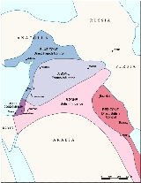
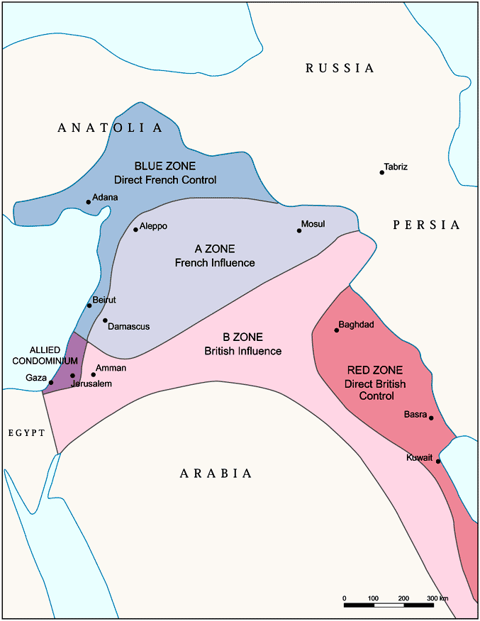 The Sykes-Picot Agreement
of 1916 secretly divided the Ottoman Empire lands of Middle East between British and French spheres of influence
. They agreed that "Palestine" was to be designated as an "international enclave".
This agreement was revised by Britain and France in 1919. It was agreed that Palestine and the Vilayet of Mosul in modern-day Iraq
would be part of the British sphere in exchange for British support of French influence in Syria and Lebanon. According to historian Ilan Pappe,
contained the principles for the boundary between the Mandates
of Palestine and Mesopotamia, attributed to Great Britain, and the Mandate of Syria
and the Lebanon
, attributed to France.
The boundary between the forthcoming British and French mandates was defined in broad terms. That agreement placed the bulk of the Golan Heights in the French sphere. The treaty also established a joint commission to settle the border and mark it on the ground. The commission submitted its final report on 3 February 1922, and it was approved with some caveats by the British and French governments on 7 March 1923, several months before Britain and France assumed their Mandatory responsibilities on 29 September 1923. In accordance with the same process, a nearby parcel of land that included the ancient site of Dan was transferred from Syria to Palestine early in 1924. In this way the Golan Heights became part of the French Mandate of Syria
. When the French Mandate of Syria ended in 1944, the Golan Heights remained part of the newly independent state of Syria.
, visited Jerusalem. After a discussion with Emir Abdullah it was agreed that the Jewish National Home objective for the proposed Palestinian Mandate territory would not apply to the Mandate territory east of the Jordan River. In accordance with that agreement, the Churchill White Paper
of June 3, 1922 stated explicitly that "the terms of the [Balfour] Declaration referred to do not contemplate that Palestine as a whole should be converted into a Jewish National Home, but that such a Home should be founded in Palestine'."
In June 1922, the League of Nations
approved the Palestine Mandate, to come into effect automatically when a dispute between France and Italy over the Syria Mandate was settled. The Mandate also stated that Britain could ‘postpone or withhold’ application of the provisions dealing with the 'Jewish National Home' in the territory east of the Jordan River, then called Transjordan
. In September 1922, the British government presented a memorandum
to the League of Nations stating that Transjordan would be excluded from all the provisions dealing with Jewish settlement, and this memorandum was approved on 23 September. The French/Italian dispute was resolved on September 29, 1923 and both Mandates came into force on that date.
Britain administered the part west of the Jordan as Palestine, and the part east of the Jordan as Transjordan, with the border being the Jordan River. Palestine comprised 23% of the Mandate territory and Transjordan comprised 77%. Technically they were one mandate but most official documents referred to them as two separate mandates. Transjordan remained under British control until 1946, when it gained independence.
 The United Nations in June 2000 was called upon to decide the Lebanese
border in order to determine whether Israel had fully withdrawn from Lebanon in compliance with Security Council Resolution 425. This line came to be called the Blue Line
. At the same time, the United Nations did not have to consider the legality of the boundary between Lebanon and the Israeli-controlled Golan Heights, as that was not required for the purpose of Resolution 425. Accordingly, the Armistice Demarcation Line between Lebanon and the Israeli-controlled Golan Heights is expressly not to be called the Blue Line.
The Blue Line, which the UN had to determine was the line of deployment of the IDF
prior to March 14, 1978, when Israel invaded Lebanon. In effect that line was recognised by both Lebanon and by Israel as the international border, and not just as the Armistice Demarcation Line of 1949 (what is commonly called the Green Line
) following the 1948 Arab-Israeli War
.
, occupying the area south of the Litani River
, excepting Tyre (see map). In response to the invasion, the UN Security Council passed Council Resolution 425 and Resolution 426 calling for the withdrawal of Israeli forces from Lebanon. Israeli forces withdrew later in 1978, but turned over their positions inside Lebanon to their ally, the South Lebanon Army
(SLA).
On April 17, 2000, Israel announced that it will withdraw its forces from Lebanon. The Lebanese government refused to take part in marking the border. The UN thus conducted its own survey based on the line for the purpose of UN Security Council Resolution 425 (1978), which called for "strict respect for the territorial integrity, sovereignty and political independence of Lebanon within its internationally recognized boundaries".
From May 24 to June 7, 2000, the UN Special Envoy heard views in Israel
, Lebanon
and Syria
. The United Nations cartographer and his team, assisted by UNIFIL, worked on the ground to identify a line to be adopted for the practical purposes of confirming the Israeli withdrawal. While it was agreed that this would not be a formal border demarcation, the aim was to identify a line on the ground closely conforming to the internationally recognized boundaries of Lebanon, based on the best available cartographic and other documentary evidence.
On May 25, 2000, Israel notified the Secretary-General that it had redeployed its forces in compliance with Council Resolution 425, that is to the Internationally recognized Lebanese border.
On June 7, the completed map showing the withdrawal line was formally transmitted by the Force Commander of UNIFIL to his Lebanese and Israeli counterparts. Notwithstanding their reservations about the line, the Governments of Israel and Lebanon confirmed that identifying this line was solely the responsibility of the United Nations and that they would respect the line as identified.
On June 8, UNIFIL teams commenced the work of verifying the Israeli withdrawal behind the line.
identified by the United Nations in 2000 as the border of Lebanon
, from the Mediterranean Sea
to the Hasbani River
, closely approximates the Green Line
set under the 1949 Armistice Agreement between Lebanon, and Israel. The area east of the Hasbani River, is considered part of Syria
http://www.law.fsu.edu/library/collection/LimitsinSeas/numericalibs-template.html and included in the Golan Heights.
The armistice agreement between Lebanon and Israel was signed on March 23, 1949. The main points were:
In 1923, 38 boundary markers were placed along the 49 mile boundary and a detailed text description was published.http://www.law.fsu.edu/library/collection/LimitsinSeas/numericalibs-template.html The 2000 Blue Line differs in about a half dozen short stretches from the 1949 line, though never by more than 475 meters.
Between 1950 and 1967, Israeli and Lebanese surveyors managed to complete 25 non-contiguous kilometers and mark (but not sign) another quarter of the international border.
On June 16, the Secretary-General reported to the Security Council that Israel had withdrawn its forces from Lebanon in accordance with Council Resolution 425 and met the requirements defined in his report of May 22, 2000.http://www.un.org/News/Press/docs/2000/20000618.sc6878.doc.html
The withdrawal line has been termed the Blue Line
in all official UN communications since.
. The British handed over the southern Golan Heights to the French in return for the northern Jordan Valley
. The border was re-drawn so that both sides of the Jordan River and the whole of the Sea of Galilee
, including a 10-metre wide strip along the northeastern shore, were made a part of Palestine. The 1947 UN Partition Plan
put this territory area inside the Jewish state.
During the Six-Day War
, Israel captured the territory, and subsequently repelled a Syrian attempt to recapture it during the Yom Kippur War
. Israel annexed the Golan Heights in 1981 with the Golan Heights Law
. Israel began building settlements
throughout the Golan Heights, and offered the Druze and Circassian residents citizenship, which most turned down. Both of these moves were disaproved of by the UN who declared the laws null and void and said that they did not affect any international law. The UN stated that Israel's move to annex the area broke international law including the Charter of the United Nations. The UN also asked Israel not to build any settlements in the area. Today, Israel regards the Golan Heights as its sovereign territory, and a strategic necessity. The Purple Line marks the boundary between Israel and Syria. Israel's unilateral annexation was not internationally recognized, and United Nations Security Council Resolution 242
refers to the area as Israeli-occupied
.
During the 1990s, there were constant negotiations between Israel and Syria regarding a mediation of conflicts and an Israeli withdrawal from the Golan Heights but a peace treaty did not come to fruition. The main stumbling block seems to involve 25 square kilometers of territory in the Jordan Valley that lays west of the 1923 Palestinian Mandate border, but which had been seized by Syria in the 1948 Arab-Israeli War
and retained by it under the 1949 Armistice Agreement with Israel. Arab countries support Syria's position in the formula which calls on Israel "to return to the 1967 borders". (See 2002 Arab Peace Initiative
)
resulted in part from the failure of French Mandate
administrations, and subsequently from the failure of the Lebanon
and Syria
to properly demarcate the border between them.
Documents from the 1920s and 1930s indicate that some local inhabitants regarded themselves as part of Lebanon, for example paying taxes to the Lebanese government. But French officials at times expressed confusion as to the actual location of the border. One French official in 1939 expressed the belief that the uncertainty was sure to cause trouble in the future.
The region continued to be represented in the 1930s and 1940s as Syrian territory, under the French Mandate. Detailed maps showing the border were produced by the French in 1933, and again in 1945. They clearly showed the region to be in Syria.
After the French Mandate ended in 1946, the land was administered by Syria, and represented as such in all maps of the time.
The maps of the 1949 Armistice Agreements
between Syria and Israel also designated the area as Syrian.
Border disputes arose at times, however. Shebaa Farms was not unique; several other border villages had similar discrepancies of borders versus land ownership. Syria and Lebanon formed a joint Syrian-Lebanese border committee in the late 1950s to determine a proper border between the two nations. In 1964, concluding its work, the committee suggested to the two governments that the area be deemed the property of Lebanon, and recommended that the international border be reestablished consistent with its suggestion. However, neither Syria nor Lebanon adopted the committee's suggestion, and neither country took any action along the suggested lines. Thus, maps of the area continued to reflect the Farms as being in Syria. Even maps of both the Syrian and Lebanese armies continued to demarcate the region within Syrian territory (see map).
A number of local residents regarded themselves as Lebanese, however. The Lebanese government showed little interest in their views. The Syrian government administered the region, and on the eve of the 1967 war, the region was under effective Syrian control.
In 1967, most Shebaa Farms landowners and (Lebanese) farmers lived outside the Syrian-controlled region, across the Lebanon-Syrian border, in the Lebanese village of Shebaa. During the Six Day War in 1967, Israel
captured the Golan Heights from Syria, including the Shebaa Farms area. As a consequence, the Lebanese landowners were no longer able to farm it.
was signed on October 26, 1994. The treaty resolved territorial and border issues that were ongoing since the 1948 war. The treaty specified and fully recognized the international border between Israel and Jordan. Upon its signing, the Jordan and Yarmouk River
s, the Dead Sea
, the Emek Ha'arva/Wadi Araba
and the Gulf of Aqaba
were officially designated as the borders between Israel and Jordan, and the border between Jordan and the territory occupied by Israel in 1967. For the latter, the agreement requires that the demarcation use a different presentation, and that it carry the following disclaimer:
(See: Israel-Jordan Peace Treaty, Annex I, Israel-Jordan International Boundary Delimitation and Demarcation.)
In 1988, Jordan ceded their claim to the West Bank
to the Palestinian Authority. The border between Israel and the West Bank is subject to ongoing negotiations in the Israel-Palestinian peace process.
and Egypt
was ratified on February 24, 1949. The armistice line between these countries followed the international border except along the Gaza Strip
, which remained under Egyptian occupation.
The Israel-Egypt Peace Treaty
, signed on March 26, 1979 created an officially recognized international border along the 1906 line, with Egypt renouncing all claims to the Gaza Strip
. A dispute arose over the marking of the border line at its southernmost point, in Taba. Taba was on the Egyptian side of the armistice line of 1949, but Israel claimed that Taba had been on the Ottoman side of a border agreed between the Ottomans and British Egypt in 1906, and that there had previously been an error in marking the line. The issue was submitted to an international commission composed of one Israeli, one Egyptian, and three outsiders. In 1988, the commission ruled in Egypt's favor, and Israel withdrew from Taba later that year.
now lay entirely within the boundaries of former British Mandate Palestine. By the Israel-Egypt Peace Treaty
of 1979, Egypt renounced all claims to the Gaza Strip
; as did Jordan in the Israel-Jordan Treaty of Peace
of 1994 to the West Bank
. Syria still claims a tiny area in the Jordan Valley.
In 1947 the United Nations had proposed a Partition Plan for the territory, which proposed the establishment of a Jewish State and an Arab State, as well as the internationalization of the Jerusalem area. The Jewish community of Mandate Palestine accepted the plan, despite its misgivings. The Arab community as well as the Arab League countries all rejected the plan, and threatened to take military measures against any partition of the territory. On 14 May 1948, on the day before the expiration of the Mandate for Palestine, the Jewish community declared the establishment of the State of Israel in the area designated by the United Nations Partition Plan for the Jewish State. On the next day, the Arab armies invaded the former Mandate territory from all sides, starting the 1948 Arab–Israeli War. When the tide of battle turned against the Arab forces, they agreed to a ceasefire in the 1949 Armistice Agreements
. Israel's expanded territorial holdings, with some minor adjustments, were made into boundaries, commonly referred to as the Green Line
. The Green Line was expressly declared in the Armistice Agreements as a temporary demarcation line
, rather than a permanent border, and the Armistice Agreements relegated the issue of permanent borders to future negotiations. The area to the west of the Jordan River came to be called the West Bank, and was annexed by Jordan in 1950; and the Gaza Strip was controlled by Egypt. Then, when Israel conquered the territories during the Six-Day War
, it did not annex them, instead placing them under military occupation
.
The Green Line is today Israel's official boundary with the Palestinian territories, with the exception of East Jerusalem
, which Israel occupied in 1967 and formally annexing in 1980 with the Jerusalem Law
, extending its eastern city limits. Israel subsequently built Jewish neighborhoods in eastern Jerusalem. The Israeli government offered the Palestinian residents citizenship, most of whom refused, and are today permanent residents
under Israeli law. The annexation of East Jerusalem was largely unrecognized by the international community; and most foreign embassies and consulates are in Tel Aviv
.
The boundaries of a future Palestinian State, vis-a-vis Israel, are subject to ongoing negotiations in the Israel-Palestinian peace process. Israel's West Bank Wall
, which encompasses almost all Israeli settlement
s, including all three major cities, and only a minor Palestinian population, was declared by Prime Minister Ehud Olmert
as running roughly along the future borders of Israel. Israeli Foreign Minister Avigdor Lieberman proposed that the Arab-Israeli border region known as the Triangle
be removed from Israeli sovereignty and transferred to the Palestinian Authority, in exchange for the border settlement blocs. The Palestinian Authority claims all of these territories (including East Jerusalem) for a future Palestinian State, and its position is supported by the Arab League in the 2002 Arab Peace Initiative
which calls for the return by Israel to "the 1967 borders". While Israel has expressed desire to annex the border settlement blocs and keep East Jerusalem, its border with Gaza has largely been solidified, especially following Israel's withdrawal
in 2005. Israel has not made claims to any portion Gazan territory, and offered the entire area to Palestinians as part of the 2000 Camp David Summit.
Border
Borders define geographic boundaries of political entities or legal jurisdictions, such as governments, sovereign states, federated states and other subnational entities. Some borders—such as a state's internal administrative borders, or inter-state borders within the Schengen Area—are open and...
s of the State of Israel
Israel
The State of Israel is a parliamentary republic located in the Middle East, along the eastern shore of the Mediterranean Sea...
. The borders have changed from time to time with developments in Israel's military and diplomatic situation. It borders Lebanon
Lebanon
Lebanon , officially the Republic of LebanonRepublic of Lebanon is the most common term used by Lebanese government agencies. The term Lebanese Republic, a literal translation of the official Arabic and French names that is not used in today's world. Arabic is the most common language spoken among...
in the north, Syria
Syria
Syria , officially the Syrian Arab Republic , is a country in Western Asia, bordering Lebanon and the Mediterranean Sea to the West, Turkey to the north, Iraq to the east, Jordan to the south, and Israel to the southwest....
in the northeast, Jordan
Jordan
Jordan , officially the Hashemite Kingdom of Jordan , Al-Mamlaka al-Urduniyya al-Hashemiyya) is a kingdom on the East Bank of the River Jordan. The country borders Saudi Arabia to the east and south-east, Iraq to the north-east, Syria to the north and the West Bank and Israel to the west, sharing...
and the West Bank
West Bank
The West Bank ) of the Jordan River is the landlocked geographical eastern part of the Palestinian territories located in Western Asia. To the west, north, and south, the West Bank shares borders with the state of Israel. To the east, across the Jordan River, lies the Hashemite Kingdom of Jordan...
in the east, the Gaza Strip
Gaza Strip
thumb|Gaza city skylineThe Gaza Strip lies on the Eastern coast of the Mediterranean Sea. The Strip borders Egypt on the southwest and Israel on the south, east and north. It is about long, and between 6 and 12 kilometres wide, with a total area of...
and Egypt
Egypt
Egypt , officially the Arab Republic of Egypt, Arabic: , is a country mainly in North Africa, with the Sinai Peninsula forming a land bridge in Southwest Asia. Egypt is thus a transcontinental country, and a major power in Africa, the Mediterranean Basin, the Middle East and the Muslim world...
on the southwest
The border with Egypt
Egypt
Egypt , officially the Arab Republic of Egypt, Arabic: , is a country mainly in North Africa, with the Sinai Peninsula forming a land bridge in Southwest Asia. Egypt is thus a transcontinental country, and a major power in Africa, the Mediterranean Basin, the Middle East and the Muslim world...
was demarcated in 1906 between Britain and the Ottoman Empire. The borders with Lebanon, Syria and Jordan are based on those drawn up by the United Kingdom and France in anticipation of the defeat of the Ottoman Empire
Ottoman Empire
The Ottoman EmpireIt was usually referred to as the "Ottoman Empire", the "Turkish Empire", the "Ottoman Caliphate" or more commonly "Turkey" by its contemporaries...
in the First World War and the carve up of the Ottoman Empire between them. They are referred to as the 1923 borders, being those of Mandate Palestine
Mandate Palestine
Mandate Palestine existed while the British Mandate for Palestine, which formally began in September 1923 and terminated in May 1948, was in effect...
, which were settled in 1923.
Israel's borders with Egypt and Jordan have now been formally recognised as part of the peace treaties with those countries, and with Lebanon as part of the 1949 Armistice Agreement. The borders with Syria and the Palestinian territories
Palestinian territories
The Palestinian territories comprise the West Bank and the Gaza Strip. Since the Palestinian Declaration of Independence in 1988, the region is today recognized by three-quarters of the world's countries as the State of Palestine or simply Palestine, although this status is not recognized by the...
are still in dispute. Israel's borders with the West Bank and Gaza Strip are currently the Green Line
Green Line (Israel)
Green Line refers to the demarcation lines set out in the 1949 Armistice Agreements between Israel and its neighbours after the 1948 Arab-Israeli War...
, except in East Jerusalem
East Jerusalem
East Jerusalem or Eastern Jerusalem refer to the parts of Jerusalem captured and annexed by Jordan in the 1948 Arab-Israeli War and then captured and annexed by Israel in the 1967 Six-Day War...
, and the ceasefire line with Syria runs along the UN-monitored boundary between the Golan Heights and Syrian sovereign territory.
The Sykes-Picot Line
Sykes-Picot Agreement
The Sykes–Picot Agreement of 1916 was a secret agreement between the governments of the United Kingdom and France, with the assent of Imperial Russia, defining their respective spheres of influence and control in Western Asia after the expected downfall of the Ottoman Empire during World War I...
of 1916 secretly divided the Ottoman Empire lands of Middle East between British and French spheres of influence
Sphere of influence
In the field of international relations, a sphere of influence is a spatial region or conceptual division over which a state or organization has significant cultural, economic, military or political influence....
. They agreed that "Palestine" was to be designated as an "international enclave".
This agreement was revised by Britain and France in 1919. It was agreed that Palestine and the Vilayet of Mosul in modern-day Iraq
Iraq
Iraq ; officially the Republic of Iraq is a country in Western Asia spanning most of the northwestern end of the Zagros mountain range, the eastern part of the Syrian Desert and the northern part of the Arabian Desert....
would be part of the British sphere in exchange for British support of French influence in Syria and Lebanon. According to historian Ilan Pappe,
"The borders of mandatory Palestine, first drawn up in the Sykes-Picot Agreement, were given their definitive shape during lengthy and tedious negotiations by British and French officials between 1919 and 1922...In October 1919 the British envisaged the area that is today southern Lebanon and most of southern Syria as being part of British mandatory Palestine...In the East, matters were more complicated...[Transjordan] was part of the Ottoman province of Damascus which in the Sykes-Picot agreement had been allocated to the French."At the San Remo Conference (19–26 April 1920) the Allied Supreme Council granted the mandates for Palestine and Mesopotamia to Britain without precisely defining the boundaries of the mandated territories. Although the land east of the Jordan had been part of the Syrian administrative unit under the Ottomans, it was excluded from the French Mandate at the San Remo conference, "on the grounds that it was part of Palestine."
Franco-British Boundary Agreement (1920)
The Franco-British Boundary Agreement (1920)Franco-British Boundary Agreement (1920)
The Franco-British Boundary Agreement of 1920, properly called the Franco-British Convention on Certain Points Connected with the Mandates for Syria and the Lebanon, Palestine and Mesopotamia, was an agreement signed between the British and French governments in Paris, on 23 December 1920...
contained the principles for the boundary between the Mandates
League of Nations mandate
A League of Nations mandate was a legal status for certain territories transferred from the control of one country to another following World War I, or the legal instruments that contained the internationally agreed-upon terms for administering the territory on behalf of the League...
of Palestine and Mesopotamia, attributed to Great Britain, and the Mandate of Syria
French Mandate of Syria
Officially the French Mandate for Syria and the Lebanon was a League of Nations mandate founded after the First World War and the partitioning of the Ottoman Empire...
and the Lebanon
French Mandate of Lebanon
The state of Greater Lebanon, the predecessor of modern Lebanon, was created in 1920 as part of the French scheme of dividing the French Mandate of Syria into six states....
, attributed to France.
The boundary between the forthcoming British and French mandates was defined in broad terms. That agreement placed the bulk of the Golan Heights in the French sphere. The treaty also established a joint commission to settle the border and mark it on the ground. The commission submitted its final report on 3 February 1922, and it was approved with some caveats by the British and French governments on 7 March 1923, several months before Britain and France assumed their Mandatory responsibilities on 29 September 1923. In accordance with the same process, a nearby parcel of land that included the ancient site of Dan was transferred from Syria to Palestine early in 1924. In this way the Golan Heights became part of the French Mandate of Syria
French Mandate of Syria
Officially the French Mandate for Syria and the Lebanon was a League of Nations mandate founded after the First World War and the partitioning of the Ottoman Empire...
. When the French Mandate of Syria ended in 1944, the Golan Heights remained part of the newly independent state of Syria.
Transjordan
In March 1921, Colonial Secretary, Winston ChurchillWinston Churchill
Sir Winston Leonard Spencer-Churchill, was a predominantly Conservative British politician and statesman known for his leadership of the United Kingdom during the Second World War. He is widely regarded as one of the greatest wartime leaders of the century and served as Prime Minister twice...
, visited Jerusalem. After a discussion with Emir Abdullah it was agreed that the Jewish National Home objective for the proposed Palestinian Mandate territory would not apply to the Mandate territory east of the Jordan River. In accordance with that agreement, the Churchill White Paper
Churchill White Paper, 1922
The Churchill White Paper of 3 June 1922 clarified how Britain viewed the Balfour Declaration, 1917...
of June 3, 1922 stated explicitly that "the terms of the [Balfour] Declaration referred to do not contemplate that Palestine as a whole should be converted into a Jewish National Home, but that such a Home should be founded in Palestine'."
In June 1922, the League of Nations
League of Nations
The League of Nations was an intergovernmental organization founded as a result of the Paris Peace Conference that ended the First World War. It was the first permanent international organization whose principal mission was to maintain world peace...
approved the Palestine Mandate, to come into effect automatically when a dispute between France and Italy over the Syria Mandate was settled. The Mandate also stated that Britain could ‘postpone or withhold’ application of the provisions dealing with the 'Jewish National Home' in the territory east of the Jordan River, then called Transjordan
Transjordan
The Emirate of Transjordan was a former Ottoman territory in the Southern Levant that was part of the British Mandate of Palestine...
. In September 1922, the British government presented a memorandum
Transjordan memorandum
The Transjordan memorandum was a British memorandum passed by the Council of the League of Nations on September 16, 1922. The memorandum described how the British government planned to implement the article of the Mandate for Palestine which allowed exclusion of Transjordan from the provisions...
to the League of Nations stating that Transjordan would be excluded from all the provisions dealing with Jewish settlement, and this memorandum was approved on 23 September. The French/Italian dispute was resolved on September 29, 1923 and both Mandates came into force on that date.
Britain administered the part west of the Jordan as Palestine, and the part east of the Jordan as Transjordan, with the border being the Jordan River. Palestine comprised 23% of the Mandate territory and Transjordan comprised 77%. Technically they were one mandate but most official documents referred to them as two separate mandates. Transjordan remained under British control until 1946, when it gained independence.
Border with Lebanon
Lebanon
Lebanon , officially the Republic of LebanonRepublic of Lebanon is the most common term used by Lebanese government agencies. The term Lebanese Republic, a literal translation of the official Arabic and French names that is not used in today's world. Arabic is the most common language spoken among...
border in order to determine whether Israel had fully withdrawn from Lebanon in compliance with Security Council Resolution 425. This line came to be called the Blue Line
Blue Line (Lebanon)
The Blue Line is a border demarcation between Lebanon and Israel published by the United Nations on 7 June 2000 for the purposes of determining whether Israel had fully withdrawn from Lebanon...
. At the same time, the United Nations did not have to consider the legality of the boundary between Lebanon and the Israeli-controlled Golan Heights, as that was not required for the purpose of Resolution 425. Accordingly, the Armistice Demarcation Line between Lebanon and the Israeli-controlled Golan Heights is expressly not to be called the Blue Line.
The Blue Line, which the UN had to determine was the line of deployment of the IDF
Israel Defense Forces
The Israel Defense Forces , commonly known in Israel by the Hebrew acronym Tzahal , are the military forces of the State of Israel. They consist of the ground forces, air force and navy. It is the sole military wing of the Israeli security forces, and has no civilian jurisdiction within Israel...
prior to March 14, 1978, when Israel invaded Lebanon. In effect that line was recognised by both Lebanon and by Israel as the international border, and not just as the Armistice Demarcation Line of 1949 (what is commonly called the Green Line
Green Line (Israel)
Green Line refers to the demarcation lines set out in the 1949 Armistice Agreements between Israel and its neighbours after the 1948 Arab-Israeli War...
) following the 1948 Arab-Israeli War
1948 Arab-Israeli War
The 1948 Arab–Israeli War, known to Israelis as the War of Independence or War of Liberation The war commenced after the termination of the British Mandate for Palestine and the creation of an independent Israel at midnight on 14 May 1948 when, following a period of civil war, Arab armies invaded...
.
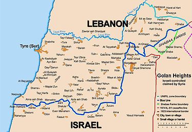
Background
On March 14, 1978, Israel launched Operation LitaniOperation Litani
The 1978 South Lebanon conflict was an invasion in Lebanon up to the Litani River carried out by the Israel Defense Forces in 1978. It was a military success for the Israeli Defense Forces, as PLO forces were pushed north of the river...
, occupying the area south of the Litani River
Litani River
The Litani River is an important water resource in southern Lebanon. The river rises in the fertile Beqaa Valley valley, west of Baalbek, and empties into the Mediterranean Sea north of Tyre. Exceeding 140 km in length, the Litani River is the longest river in Lebanon and provides an average...
, excepting Tyre (see map). In response to the invasion, the UN Security Council passed Council Resolution 425 and Resolution 426 calling for the withdrawal of Israeli forces from Lebanon. Israeli forces withdrew later in 1978, but turned over their positions inside Lebanon to their ally, the South Lebanon Army
South Lebanon Army
The South Lebanon Army , also "South Lebanese Army," was a Lebanese militia during the Lebanese Civil War. After 1979, the militia operated in southern Lebanon under the authority of Saad Haddad's Government of Free Lebanon...
(SLA).
On April 17, 2000, Israel announced that it will withdraw its forces from Lebanon. The Lebanese government refused to take part in marking the border. The UN thus conducted its own survey based on the line for the purpose of UN Security Council Resolution 425 (1978), which called for "strict respect for the territorial integrity, sovereignty and political independence of Lebanon within its internationally recognized boundaries".
From May 24 to June 7, 2000, the UN Special Envoy heard views in Israel
Israel
The State of Israel is a parliamentary republic located in the Middle East, along the eastern shore of the Mediterranean Sea...
, Lebanon
Lebanon
Lebanon , officially the Republic of LebanonRepublic of Lebanon is the most common term used by Lebanese government agencies. The term Lebanese Republic, a literal translation of the official Arabic and French names that is not used in today's world. Arabic is the most common language spoken among...
and Syria
Syria
Syria , officially the Syrian Arab Republic , is a country in Western Asia, bordering Lebanon and the Mediterranean Sea to the West, Turkey to the north, Iraq to the east, Jordan to the south, and Israel to the southwest....
. The United Nations cartographer and his team, assisted by UNIFIL, worked on the ground to identify a line to be adopted for the practical purposes of confirming the Israeli withdrawal. While it was agreed that this would not be a formal border demarcation, the aim was to identify a line on the ground closely conforming to the internationally recognized boundaries of Lebanon, based on the best available cartographic and other documentary evidence.
On May 25, 2000, Israel notified the Secretary-General that it had redeployed its forces in compliance with Council Resolution 425, that is to the Internationally recognized Lebanese border.
On June 7, the completed map showing the withdrawal line was formally transmitted by the Force Commander of UNIFIL to his Lebanese and Israeli counterparts. Notwithstanding their reservations about the line, the Governments of Israel and Lebanon confirmed that identifying this line was solely the responsibility of the United Nations and that they would respect the line as identified.
On June 8, UNIFIL teams commenced the work of verifying the Israeli withdrawal behind the line.
The Blue Line
The Blue LineBlue Line (Lebanon)
The Blue Line is a border demarcation between Lebanon and Israel published by the United Nations on 7 June 2000 for the purposes of determining whether Israel had fully withdrawn from Lebanon...
identified by the United Nations in 2000 as the border of Lebanon
Lebanon
Lebanon , officially the Republic of LebanonRepublic of Lebanon is the most common term used by Lebanese government agencies. The term Lebanese Republic, a literal translation of the official Arabic and French names that is not used in today's world. Arabic is the most common language spoken among...
, from the Mediterranean Sea
Mediterranean Sea
The Mediterranean Sea is a sea connected to the Atlantic Ocean surrounded by the Mediterranean region and almost completely enclosed by land: on the north by Anatolia and Europe, on the south by North Africa, and on the east by the Levant...
to the Hasbani River
Hasbani River
The Hasbani River , also known as Snir Stream within Israel, is a tributary of the Jordan river.The Hasbani River derives most of its discharge from two springs in Lebanon, the Wazzani and the Haqzbieh, the latter being a group of springs on the uppermost Hasbani...
, closely approximates the Green Line
Green Line (Israel)
Green Line refers to the demarcation lines set out in the 1949 Armistice Agreements between Israel and its neighbours after the 1948 Arab-Israeli War...
set under the 1949 Armistice Agreement between Lebanon, and Israel. The area east of the Hasbani River, is considered part of Syria
Syria
Syria , officially the Syrian Arab Republic , is a country in Western Asia, bordering Lebanon and the Mediterranean Sea to the West, Turkey to the north, Iraq to the east, Jordan to the south, and Israel to the southwest....
http://www.law.fsu.edu/library/collection/LimitsinSeas/numericalibs-template.html and included in the Golan Heights.
The armistice agreement between Lebanon and Israel was signed on March 23, 1949. The main points were:
- The terms of the agreement were dictated exclusively by military considerations
- The armistice line (i.e. "Green LineGreen Line (Israel)Green Line refers to the demarcation lines set out in the 1949 Armistice Agreements between Israel and its neighbours after the 1948 Arab-Israeli War...
") was the international border, which corresponds to the 1923 Mandate border between the LebanonLebanonLebanon , officially the Republic of LebanonRepublic of Lebanon is the most common term used by Lebanese government agencies. The term Lebanese Republic, a literal translation of the official Arabic and French names that is not used in today's world. Arabic is the most common language spoken among...
and PalestinePalestinePalestine is a conventional name, among others, used to describe the geographic region between the Mediterranean Sea and the Jordan River, and various adjoining lands....
(see: Treaty of SèvresTreaty of SèvresThe Treaty of Sèvres was the peace treaty between the Ottoman Empire and Allies at the end of World War I. The Treaty of Versailles was signed with Germany before this treaty to annul the German concessions including the economic rights and enterprises. Also, France, Great Britain and Italy...
). - Unlike the other Green Line agreements, it contains no clause disclaiming this line as an international border, and was thereafter treated as it had been previously, as the de jureDe jureDe jure is an expression that means "concerning law", as contrasted with de facto, which means "concerning fact".De jure = 'Legally', De facto = 'In fact'....
international border of Lebanon. - Israel withdrew its forces from 13 villages in Lebanese territory, which were occupied during the war.
In 1923, 38 boundary markers were placed along the 49 mile boundary and a detailed text description was published.http://www.law.fsu.edu/library/collection/LimitsinSeas/numericalibs-template.html The 2000 Blue Line differs in about a half dozen short stretches from the 1949 line, though never by more than 475 meters.
Between 1950 and 1967, Israeli and Lebanese surveyors managed to complete 25 non-contiguous kilometers and mark (but not sign) another quarter of the international border.
On June 16, the Secretary-General reported to the Security Council that Israel had withdrawn its forces from Lebanon in accordance with Council Resolution 425 and met the requirements defined in his report of May 22, 2000.http://www.un.org/News/Press/docs/2000/20000618.sc6878.doc.html
The withdrawal line has been termed the Blue Line
Blue Line (Lebanon)
The Blue Line is a border demarcation between Lebanon and Israel published by the United Nations on 7 June 2000 for the purposes of determining whether Israel had fully withdrawn from Lebanon...
in all official UN communications since.
Border with Syria
In 1923, an agreement between the United Kingdom and France established the border between the British Mandate of Palestine and the French Mandate of SyriaFrench Mandate of Syria
Officially the French Mandate for Syria and the Lebanon was a League of Nations mandate founded after the First World War and the partitioning of the Ottoman Empire...
. The British handed over the southern Golan Heights to the French in return for the northern Jordan Valley
Jordan Valley (Middle East)
The Jordan Valley forms part of the larger Jordan Rift Valley. It is 120 kilometers long and 15 kilometers wide, where it runs from Lake Tiberias in the north to northern Dead Sea in the south. It runs for an additional 155 kilometer south of the Dead Sea to Aqaba, an area also known as Wadi...
. The border was re-drawn so that both sides of the Jordan River and the whole of the Sea of Galilee
Sea of Galilee
The Sea of Galilee, also Kinneret, Lake of Gennesaret, or Lake Tiberias , is the largest freshwater lake in Israel, and it is approximately in circumference, about long, and wide. The lake has a total area of , and a maximum depth of approximately 43 m...
, including a 10-metre wide strip along the northeastern shore, were made a part of Palestine. The 1947 UN Partition Plan
1947 UN Partition Plan
The United Nations Partition Plan for Palestine was created by the United Nations Special Committee on Palestine in 1947 to replace the British Mandate for Palestine with "Independent Arab and Jewish States" and a "Special International Regime for the City of Jerusalem" administered by the United...
put this territory area inside the Jewish state.
During the Six-Day War
Six-Day War
The Six-Day War , also known as the June War, 1967 Arab-Israeli War, or Third Arab-Israeli War, was fought between June 5 and 10, 1967, by Israel and the neighboring states of Egypt , Jordan, and Syria...
, Israel captured the territory, and subsequently repelled a Syrian attempt to recapture it during the Yom Kippur War
Yom Kippur War
The Yom Kippur War, Ramadan War or October War , also known as the 1973 Arab-Israeli War and the Fourth Arab-Israeli War, was fought from October 6 to 25, 1973, between Israel and a coalition of Arab states led by Egypt and Syria...
. Israel annexed the Golan Heights in 1981 with the Golan Heights Law
Golan Heights Law
The Golan Heights Law is the Israeli law which applies Israel's government and laws to the Golan Heights. It was ratified by the Knesset on December 14, 1981. The law was condemned internationally and determined null and void by United Nations Security Council Resolution 497.The law was passed...
. Israel began building settlements
Israeli settlement
An Israeli settlement is a Jewish civilian community built on land that was captured by Israel from Jordan, Egypt, and Syria during the 1967 Six-Day War and is considered occupied territory by the international community. Such settlements currently exist in the West Bank...
throughout the Golan Heights, and offered the Druze and Circassian residents citizenship, which most turned down. Both of these moves were disaproved of by the UN who declared the laws null and void and said that they did not affect any international law. The UN stated that Israel's move to annex the area broke international law including the Charter of the United Nations. The UN also asked Israel not to build any settlements in the area. Today, Israel regards the Golan Heights as its sovereign territory, and a strategic necessity. The Purple Line marks the boundary between Israel and Syria. Israel's unilateral annexation was not internationally recognized, and United Nations Security Council Resolution 242
United Nations Security Council Resolution 242
United Nations Security Council Resolution 242 was adopted unanimously by the UN Security Council on November 22, 1967, in the aftermath of the Six Day War. It was adopted under Chapter VIof the United Nations Charter...
refers to the area as Israeli-occupied
Israeli-occupied territories
The Israeli-occupied territories are the territories which have been designated as occupied territory by the United Nations and other international organizations, governments and others to refer to the territory seized by Israel during the Six-Day War of 1967 from Egypt, Jordan, and Syria...
.
During the 1990s, there were constant negotiations between Israel and Syria regarding a mediation of conflicts and an Israeli withdrawal from the Golan Heights but a peace treaty did not come to fruition. The main stumbling block seems to involve 25 square kilometers of territory in the Jordan Valley that lays west of the 1923 Palestinian Mandate border, but which had been seized by Syria in the 1948 Arab-Israeli War
1948 Arab-Israeli War
The 1948 Arab–Israeli War, known to Israelis as the War of Independence or War of Liberation The war commenced after the termination of the British Mandate for Palestine and the creation of an independent Israel at midnight on 14 May 1948 when, following a period of civil war, Arab armies invaded...
and retained by it under the 1949 Armistice Agreement with Israel. Arab countries support Syria's position in the formula which calls on Israel "to return to the 1967 borders". (See 2002 Arab Peace Initiative
Arab Peace Initiative
The Beirut Summit was a meeting of the Arab League in Beirut, Lebanon in March 2002 to discuss the Israeli-Palestinian conflict. The meeting became especially noteworthy for the adoption, by the Arab states attending, of a proposal offering a comprehensive peace between the Arab countries and...
)
Conflict over the Shebaa Farms
Both Lebanon and Syria were within the French Mandate Territory between 1920 and the end of the French Mandate in 1946. The dispute over the sovereignty over the Shebaa FarmsShebaa farms
The Shebaa Farms are a small uninhabited territory claimed by Lebanon, but occupied by Israel which claims they are in Syria's Golan Heights. Syrian policy is to vaguely accept the Lebanese claim, while refusing any binding demarcation until Israeli forces withdraw from the area.The United Nations...
resulted in part from the failure of French Mandate
League of Nations mandate
A League of Nations mandate was a legal status for certain territories transferred from the control of one country to another following World War I, or the legal instruments that contained the internationally agreed-upon terms for administering the territory on behalf of the League...
administrations, and subsequently from the failure of the Lebanon
Lebanon
Lebanon , officially the Republic of LebanonRepublic of Lebanon is the most common term used by Lebanese government agencies. The term Lebanese Republic, a literal translation of the official Arabic and French names that is not used in today's world. Arabic is the most common language spoken among...
and Syria
Syria
Syria , officially the Syrian Arab Republic , is a country in Western Asia, bordering Lebanon and the Mediterranean Sea to the West, Turkey to the north, Iraq to the east, Jordan to the south, and Israel to the southwest....
to properly demarcate the border between them.
Documents from the 1920s and 1930s indicate that some local inhabitants regarded themselves as part of Lebanon, for example paying taxes to the Lebanese government. But French officials at times expressed confusion as to the actual location of the border. One French official in 1939 expressed the belief that the uncertainty was sure to cause trouble in the future.
The region continued to be represented in the 1930s and 1940s as Syrian territory, under the French Mandate. Detailed maps showing the border were produced by the French in 1933, and again in 1945. They clearly showed the region to be in Syria.
After the French Mandate ended in 1946, the land was administered by Syria, and represented as such in all maps of the time.
The maps of the 1949 Armistice Agreements
1949 Armistice Agreements
The 1949 Armistice Agreements are a set of agreements signed during 1949 between Israel and neighboring Egypt, Lebanon, Jordan, and Syria. The agreements ended the official hostilities of the 1948 Arab-Israeli War, and established armistice lines between Israeli forces and the forces in...
between Syria and Israel also designated the area as Syrian.
Border disputes arose at times, however. Shebaa Farms was not unique; several other border villages had similar discrepancies of borders versus land ownership. Syria and Lebanon formed a joint Syrian-Lebanese border committee in the late 1950s to determine a proper border between the two nations. In 1964, concluding its work, the committee suggested to the two governments that the area be deemed the property of Lebanon, and recommended that the international border be reestablished consistent with its suggestion. However, neither Syria nor Lebanon adopted the committee's suggestion, and neither country took any action along the suggested lines. Thus, maps of the area continued to reflect the Farms as being in Syria. Even maps of both the Syrian and Lebanese armies continued to demarcate the region within Syrian territory (see map).
A number of local residents regarded themselves as Lebanese, however. The Lebanese government showed little interest in their views. The Syrian government administered the region, and on the eve of the 1967 war, the region was under effective Syrian control.
In 1967, most Shebaa Farms landowners and (Lebanese) farmers lived outside the Syrian-controlled region, across the Lebanon-Syrian border, in the Lebanese village of Shebaa. During the Six Day War in 1967, Israel
Israel
The State of Israel is a parliamentary republic located in the Middle East, along the eastern shore of the Mediterranean Sea...
captured the Golan Heights from Syria, including the Shebaa Farms area. As a consequence, the Lebanese landowners were no longer able to farm it.
Border with Jordan
The Israel-Jordan Treaty of PeaceIsrael-Jordan Treaty of Peace
The Israel–Jordan Treaty of Peace was signed in 1994. The treaty normalized relations between the two countries and resolved territorial disputes. The conflict had cost roughly US$18.3 billion...
was signed on October 26, 1994. The treaty resolved territorial and border issues that were ongoing since the 1948 war. The treaty specified and fully recognized the international border between Israel and Jordan. Upon its signing, the Jordan and Yarmouk River
Yarmouk River
The Yarmouk River is the largest tributary of the Jordan River. It drains much of the Hauran Plateau. It is one of three main tributaries which enter the Jordan between the Sea of Galilee and the Dead Sea. To the south, are the Jabbok/Zarqa and the Arnon/Wadi Mujib) rivers...
s, the Dead Sea
Dead Sea
The Dead Sea , also called the Salt Sea, is a salt lake bordering Jordan to the east and Israel and the West Bank to the west. Its surface and shores are below sea level, the lowest elevation on the Earth's surface. The Dead Sea is deep, the deepest hypersaline lake in the world...
, the Emek Ha'arva/Wadi Araba
Arabah
The Arabah , also known as Aravah, is a section of the Great Rift Valley running in a north-south orientation between the southern end of the Sea of Galilee down to the Dead Sea and continuing further south where it ends at the Gulf of Aqaba. It includes most of the border between Israel to the...
and the Gulf of Aqaba
Gulf of Aqaba
The Gulf of Aqaba is a large gulf located at the northern tip of the Red Sea. In pre twentieth-century and modern sources it is often named the Gulf of Eilat, as Eilat is its predominant Israeli city ....
were officially designated as the borders between Israel and Jordan, and the border between Jordan and the territory occupied by Israel in 1967. For the latter, the agreement requires that the demarcation use a different presentation, and that it carry the following disclaimer:
"This line is the administrative boundary between Jordan and the territory which came under Israeli military government control in 1967. Any treatment of this line shall be without prejudice to the status of the territory."
(See: Israel-Jordan Peace Treaty, Annex I, Israel-Jordan International Boundary Delimitation and Demarcation.)
In 1988, Jordan ceded their claim to the West Bank
West Bank
The West Bank ) of the Jordan River is the landlocked geographical eastern part of the Palestinian territories located in Western Asia. To the west, north, and south, the West Bank shares borders with the state of Israel. To the east, across the Jordan River, lies the Hashemite Kingdom of Jordan...
to the Palestinian Authority. The border between Israel and the West Bank is subject to ongoing negotiations in the Israel-Palestinian peace process.
Border with Egypt
The 1949 Armistice Agreement between IsraelIsrael
The State of Israel is a parliamentary republic located in the Middle East, along the eastern shore of the Mediterranean Sea...
and Egypt
Egypt
Egypt , officially the Arab Republic of Egypt, Arabic: , is a country mainly in North Africa, with the Sinai Peninsula forming a land bridge in Southwest Asia. Egypt is thus a transcontinental country, and a major power in Africa, the Mediterranean Basin, the Middle East and the Muslim world...
was ratified on February 24, 1949. The armistice line between these countries followed the international border except along the Gaza Strip
Gaza Strip
thumb|Gaza city skylineThe Gaza Strip lies on the Eastern coast of the Mediterranean Sea. The Strip borders Egypt on the southwest and Israel on the south, east and north. It is about long, and between 6 and 12 kilometres wide, with a total area of...
, which remained under Egyptian occupation.
The Israel-Egypt Peace Treaty
Israel-Egypt Peace Treaty
The 1979 Egypt–Israel Peace Treaty was signed in Washington, D.C. on the 26th of March 1979, following the 1978 Camp David Accords, which were signed by Egyptian President Anwar El Sadat and Israeli Prime Minister Menachem Begin, and were witnessed by United States President Jimmy Carter.The peace...
, signed on March 26, 1979 created an officially recognized international border along the 1906 line, with Egypt renouncing all claims to the Gaza Strip
Gaza Strip
thumb|Gaza city skylineThe Gaza Strip lies on the Eastern coast of the Mediterranean Sea. The Strip borders Egypt on the southwest and Israel on the south, east and north. It is about long, and between 6 and 12 kilometres wide, with a total area of...
. A dispute arose over the marking of the border line at its southernmost point, in Taba. Taba was on the Egyptian side of the armistice line of 1949, but Israel claimed that Taba had been on the Ottoman side of a border agreed between the Ottomans and British Egypt in 1906, and that there had previously been an error in marking the line. The issue was submitted to an international commission composed of one Israeli, one Egyptian, and three outsiders. In 1988, the commission ruled in Egypt's favor, and Israel withdrew from Taba later that year.
Borders with Palestinian territories
Israel and the Palestinian territoriesPalestinian territories
The Palestinian territories comprise the West Bank and the Gaza Strip. Since the Palestinian Declaration of Independence in 1988, the region is today recognized by three-quarters of the world's countries as the State of Palestine or simply Palestine, although this status is not recognized by the...
now lay entirely within the boundaries of former British Mandate Palestine. By the Israel-Egypt Peace Treaty
Israel-Egypt Peace Treaty
The 1979 Egypt–Israel Peace Treaty was signed in Washington, D.C. on the 26th of March 1979, following the 1978 Camp David Accords, which were signed by Egyptian President Anwar El Sadat and Israeli Prime Minister Menachem Begin, and were witnessed by United States President Jimmy Carter.The peace...
of 1979, Egypt renounced all claims to the Gaza Strip
Gaza Strip
thumb|Gaza city skylineThe Gaza Strip lies on the Eastern coast of the Mediterranean Sea. The Strip borders Egypt on the southwest and Israel on the south, east and north. It is about long, and between 6 and 12 kilometres wide, with a total area of...
; as did Jordan in the Israel-Jordan Treaty of Peace
Israel-Jordan Treaty of Peace
The Israel–Jordan Treaty of Peace was signed in 1994. The treaty normalized relations between the two countries and resolved territorial disputes. The conflict had cost roughly US$18.3 billion...
of 1994 to the West Bank
West Bank
The West Bank ) of the Jordan River is the landlocked geographical eastern part of the Palestinian territories located in Western Asia. To the west, north, and south, the West Bank shares borders with the state of Israel. To the east, across the Jordan River, lies the Hashemite Kingdom of Jordan...
. Syria still claims a tiny area in the Jordan Valley.
In 1947 the United Nations had proposed a Partition Plan for the territory, which proposed the establishment of a Jewish State and an Arab State, as well as the internationalization of the Jerusalem area. The Jewish community of Mandate Palestine accepted the plan, despite its misgivings. The Arab community as well as the Arab League countries all rejected the plan, and threatened to take military measures against any partition of the territory. On 14 May 1948, on the day before the expiration of the Mandate for Palestine, the Jewish community declared the establishment of the State of Israel in the area designated by the United Nations Partition Plan for the Jewish State. On the next day, the Arab armies invaded the former Mandate territory from all sides, starting the 1948 Arab–Israeli War. When the tide of battle turned against the Arab forces, they agreed to a ceasefire in the 1949 Armistice Agreements
1949 Armistice Agreements
The 1949 Armistice Agreements are a set of agreements signed during 1949 between Israel and neighboring Egypt, Lebanon, Jordan, and Syria. The agreements ended the official hostilities of the 1948 Arab-Israeli War, and established armistice lines between Israeli forces and the forces in...
. Israel's expanded territorial holdings, with some minor adjustments, were made into boundaries, commonly referred to as the Green Line
Green Line (Israel)
Green Line refers to the demarcation lines set out in the 1949 Armistice Agreements between Israel and its neighbours after the 1948 Arab-Israeli War...
. The Green Line was expressly declared in the Armistice Agreements as a temporary demarcation line
Demarcation line
A demarcation line means simply a boundary around a specific area, but is commonly used to denote a temporary geopolitical border, often agreed upon as part of an armistice or ceasefire.See the following examples:...
, rather than a permanent border, and the Armistice Agreements relegated the issue of permanent borders to future negotiations. The area to the west of the Jordan River came to be called the West Bank, and was annexed by Jordan in 1950; and the Gaza Strip was controlled by Egypt. Then, when Israel conquered the territories during the Six-Day War
Six-Day War
The Six-Day War , also known as the June War, 1967 Arab-Israeli War, or Third Arab-Israeli War, was fought between June 5 and 10, 1967, by Israel and the neighboring states of Egypt , Jordan, and Syria...
, it did not annex them, instead placing them under military occupation
Military occupation
Military occupation occurs when the control and authority over a territory passes to a hostile army. The territory then becomes occupied territory.-Military occupation and the laws of war:...
.
The Green Line is today Israel's official boundary with the Palestinian territories, with the exception of East Jerusalem
East Jerusalem
East Jerusalem or Eastern Jerusalem refer to the parts of Jerusalem captured and annexed by Jordan in the 1948 Arab-Israeli War and then captured and annexed by Israel in the 1967 Six-Day War...
, which Israel occupied in 1967 and formally annexing in 1980 with the Jerusalem Law
Jerusalem Law
The Jerusalem Law is a common name of Basic Law: Jerusalem, Capital of Israel passed by the Knesset on July 30, 1980 .It began as a private member's bill proposed by Geula Cohen, whose original text stated that "the integrity and unity of greater Jerusalem in its boundaries after the Six-Day War...
, extending its eastern city limits. Israel subsequently built Jewish neighborhoods in eastern Jerusalem. The Israeli government offered the Palestinian residents citizenship, most of whom refused, and are today permanent residents
Permanent residency
Permanent residency refers to a person's visa status: the person is allowed to reside indefinitely within a country of which he or she is not a citizen. A person with such status is known as a permanent resident....
under Israeli law. The annexation of East Jerusalem was largely unrecognized by the international community; and most foreign embassies and consulates are in Tel Aviv
Tel Aviv
Tel Aviv , officially Tel Aviv-Yafo , is the second most populous city in Israel, with a population of 404,400 on a land area of . The city is located on the Israeli Mediterranean coastline in west-central Israel. It is the largest and most populous city in the metropolitan area of Gush Dan, with...
.
The boundaries of a future Palestinian State, vis-a-vis Israel, are subject to ongoing negotiations in the Israel-Palestinian peace process. Israel's West Bank Wall
Israeli West Bank barrier
The Israeli West Bank barrier is a separation barrier being constructed by the State of Israel along and within the West Bank. Upon completion, the barrier’s total length will be approximately...
, which encompasses almost all Israeli settlement
Israeli settlement
An Israeli settlement is a Jewish civilian community built on land that was captured by Israel from Jordan, Egypt, and Syria during the 1967 Six-Day War and is considered occupied territory by the international community. Such settlements currently exist in the West Bank...
s, including all three major cities, and only a minor Palestinian population, was declared by Prime Minister Ehud Olmert
Ehud Olmert
Ehud Olmert is an Israeli politician and lawyer. He served as Prime Minister of Israel from 2006 to 2009, as a Cabinet Minister from 1988 to 1992 and from 2003 to 2006, and as Mayor of Jerusalem from 1993 to 2003....
as running roughly along the future borders of Israel. Israeli Foreign Minister Avigdor Lieberman proposed that the Arab-Israeli border region known as the Triangle
Triangle (Israel)
The Triangle , formerly referred to as the Little Triangle, is a concentration of Israeli Arab towns and villages adjacent to the Green Line, located in the eastern Sharon plain among the Samarian foothills; this area is located within the easternmost boundaries of both the Center District and...
be removed from Israeli sovereignty and transferred to the Palestinian Authority, in exchange for the border settlement blocs. The Palestinian Authority claims all of these territories (including East Jerusalem) for a future Palestinian State, and its position is supported by the Arab League in the 2002 Arab Peace Initiative
Arab Peace Initiative
The Beirut Summit was a meeting of the Arab League in Beirut, Lebanon in March 2002 to discuss the Israeli-Palestinian conflict. The meeting became especially noteworthy for the adoption, by the Arab states attending, of a proposal offering a comprehensive peace between the Arab countries and...
which calls for the return by Israel to "the 1967 borders". While Israel has expressed desire to annex the border settlement blocs and keep East Jerusalem, its border with Gaza has largely been solidified, especially following Israel's withdrawal
Israel's unilateral disengagement plan
Israel's unilateral disengagement plan , also known as the "Disengagement plan", "Gaza expulsion plan", and "Hitnatkut", was a proposal by Israeli Prime Minister Ariel Sharon, adopted by the government on June 6, 2004 and enacted in August 2005, to evict all Israelis from the Gaza Strip and from...
in 2005. Israel has not made claims to any portion Gazan territory, and offered the entire area to Palestinians as part of the 2000 Camp David Summit.