
Black Ridge Canyons Wilderness
Encyclopedia
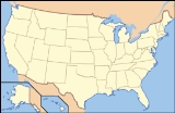
The Black Ridge Canyons Wilderness (BRCW) is located in western Colorado
and eastern Utah
, USA
, within the arid Colorado Plateau
region approximately 15 miles (24 km) west of Grand Junction, Colorado
. The wilderness lies on the northwest flank of the Uncompahgre Plateau
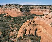
. It is characterized by the high, east-west trending Black Ridge dissected by seven major canyon
systems, draining into the Colorado River
in Ruby Canyon
. Elevations range from 4700 feet (1,432.6 m) above sea level
along the river to 6800 feet (2,072.6 m). Canyons vary in length from several miles to twelve miles in length and may contain interesting side canyons. Geological features in these canyons include spires, windows, giant alcoves and desert varnish
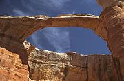
. Canyons may reach a depth of almost 1000 feet (304.8 m), forming spectacular redrock cliffs. Spring runoff and summer thunderstorms create glistening waterfalls and plunge pools. Rattlesnake Canyon
contains the second largest concentration of natural arch
es in the country. Mee Canyon
is even more remote, and contains Arch Tower.
Vegetation in the meandering canyon bottoms includes grasses, pinyon
, juniper
, cottonwood, willow
and box elder
. The upland mesa
s contain dense stands of pinyon and juniper with some sagebrush
parks. Cryptobiotic soil
s are well developed in the upland areas. Wildlife viewing may include deer
, mountain lion, desert bighorn sheep
, along with golden and bald eagle
s. The wilderness area is 75439 acres (305.29 km²) of which 70319 acres (284.57 km²) are in Colorado
and 5120 acres (20.72 km²) are in Utah
. It was designated by the U.S. Congress in 2000 and is administered by the Bureau of Land Management
. The Black Ridge Canyons Wilderness forms the core of the 123430 acres (500 km²) McInnis Canyons National Conservation Area
.
. Visitors have easy access the front country area year round while the high country and Colorado River access remain accessible only to the most dedicated visitors.
via State Highway 340
. This area, known as the "wilderness-urban interface," is a popular destination for local residents and their dogs looking for daily exercise. The Bureau of Land Management maintains three trailheads in this area - Devils Canyon, Fruita Paleontological Area and Pollock Bench.
. Visitors to this area are treated to a true wilderness experience in a rough, remote land that provides outstanding opportunities for solitude. The Rattlesnake Canyon
area is home to the world's second-largest concentration of natural arch
es (after Arches National Park
).
Mee Canyon contains a 300 feet (91 m) deep alcove
that is accessible only by way of a difficult hiking trail which requires and scrambling
over many exposed ledges. Knowles and Jones Canyons offer visitors a true wilderness experience, with outstanding opportunities for solitude and a primitive and unconfined type of recreation.
 The Colorado River bisects the McInnis Canyons National Conservation Area
and forms the northern boundary of the Black Ridge Canyons Wilderness as it winds its way through Horsethief and Ruby
canyons. The river itself is not a part of the wilderness, however floaters are able to hike up many of the main canyons of the area including Rattlesnake Canyon, Moore Canyon, Mee Canyon, and Knowles Canyon. The most popular put in to float this section of the river is the Loma boat launch in Loma, Colorado
. Most river users take out in Westwater, Utah, although some continue on through the Class III and IV rapids of Westwater Canyon (permit required).
Colorado
Colorado is a U.S. state that encompasses much of the Rocky Mountains as well as the northeastern portion of the Colorado Plateau and the western edge of the Great Plains...
and eastern Utah
Utah
Utah is a state in the Western United States. It was the 45th state to join the Union, on January 4, 1896. Approximately 80% of Utah's 2,763,885 people live along the Wasatch Front, centering on Salt Lake City. This leaves vast expanses of the state nearly uninhabited, making the population the...
, USA
United States
The United States of America is a federal constitutional republic comprising fifty states and a federal district...
, within the arid Colorado Plateau
Colorado Plateau
The Colorado Plateau, also called the Colorado Plateau Province, is a physiographic region of the Intermontane Plateaus, roughly centered on the Four Corners region of the southwestern United States. The province covers an area of 337,000 km2 within western Colorado, northwestern New Mexico,...
region approximately 15 miles (24 km) west of Grand Junction, Colorado
Grand Junction, Colorado
The City of Grand Junction is the largest city in western Colorado. It is a city with a council–manager government form that is the county seat and the most populous city of Mesa County, Colorado, United States. Grand Junction is situated west-southwest of the Colorado State Capitol in Denver. As...
. The wilderness lies on the northwest flank of the Uncompahgre Plateau
Uncompahgre Plateau
The Uncompahgre Plateau in western Colorado is a distinctive large uplift part of the Colorado Plateau. Uncompahgre is a Ute Indian word that describes the water: "Dirty Water" or "Rocks that make Water Red"....
. It is characterized by the high, east-west trending Black Ridge dissected by seven major canyon
Canyon
A canyon or gorge is a deep ravine between cliffs often carved from the landscape by a river. Rivers have a natural tendency to reach a baseline elevation, which is the same elevation as the body of water it will eventually drain into. This forms a canyon. Most canyons were formed by a process of...
systems, draining into the Colorado River
Colorado River
The Colorado River , is a river in the Southwestern United States and northwestern Mexico, approximately long, draining a part of the arid regions on the western slope of the Rocky Mountains. The watershed of the Colorado River covers in parts of seven U.S. states and two Mexican states...
in Ruby Canyon
Ruby Canyon
Ruby Canyon is a roughly 25 mile long canyon on the Colorado River located on the Colorado-Utah border in the western United States, and is a popular destination for rafting...
. Elevations range from 4700 feet (1,432.6 m) above sea level
Sea level
Mean sea level is a measure of the average height of the ocean's surface ; used as a standard in reckoning land elevation...
along the river to 6800 feet (2,072.6 m). Canyons vary in length from several miles to twelve miles in length and may contain interesting side canyons. Geological features in these canyons include spires, windows, giant alcoves and desert varnish
Desert varnish
Desert varnish, or rock varnish is a orange-yellow to black coating found on exposed rock surfaces in arid environments. Desert varnish is usually around one micron thick and present nanometre-scale layering...
. Canyons may reach a depth of almost 1000 feet (304.8 m), forming spectacular redrock cliffs. Spring runoff and summer thunderstorms create glistening waterfalls and plunge pools. Rattlesnake Canyon
Rattlesnake Canyon (Colorado)
Rattlesnake Canyon is a scenic area within the Black Ridge Canyons Wilderness which in turn forms the core of the Bureau of Land Management administered McInnis Canyons National Conservation Area in west central Colorado. The canyon contains 9 natural arches, the second highest concentration of...
contains the second largest concentration of natural arch
Natural arch
A natural arch or natural bridge is a natural geological formation where a rock arch forms, with an opening underneath. Most natural arches form as a narrow ridge, walled by cliffs, become narrower from erosion, with a softer rock stratum under the cliff-forming stratum gradually eroding out until...
es in the country. Mee Canyon
Mee Canyon
Mee Canyon is a remote scenic area within the Black Ridge Canyons Wilderness which in turn forms the core of the Bureau of Land Management administered McInnis Canyons National Conservation Area in west central Colorado...
is even more remote, and contains Arch Tower.
Vegetation in the meandering canyon bottoms includes grasses, pinyon
Pinyon pine
The pinyon pine group grows in the southwestern United States and in Mexico. The trees yield edible pinyon nuts, which were a staple of the Native Americans, and are still widely eaten...
, juniper
Juniper
Junipers are coniferous plants in the genus Juniperus of the cypress family Cupressaceae. Depending on taxonomic viewpoint, there are between 50-67 species of juniper, widely distributed throughout the northern hemisphere, from the Arctic, south to tropical Africa in the Old World, and to the...
, cottonwood, willow
Willow
Willows, sallows, and osiers form the genus Salix, around 400 species of deciduous trees and shrubs, found primarily on moist soils in cold and temperate regions of the Northern Hemisphere...
and box elder
Box Elder
Box Elder may refer to:*The Box elder, Acer negundo, a species of maple*The Box elder bug, an insect which feeds on maple trees*Box Elders, a punk band from Omaha, Nebraska*Places named "Box Elder" include:*Box Elder, Montana, United States of America...
. The upland mesa
Mesa
A mesa or table mountain is an elevated area of land with a flat top and sides that are usually steep cliffs. It takes its name from its characteristic table-top shape....
s contain dense stands of pinyon and juniper with some sagebrush
Sagebrush
Sagebrush is a common name of a number of shrubby plant species in the genus Artemisia native to western North America;Or, the sagebrush steppe ecoregion, having one or more kinds of sagebrush, bunchgrasses and others;...
parks. Cryptobiotic soil
Cryptobiotic soil
A Cryptobiotic soil is a biological soil crust composed of living cyanobacteria, green algae, brown algae, fungi, lichens, and/or mosses. Commonly found in arid regions around the world, cryptobiotic soils go by many names, including cryptogamic, microbiotic, or microphytic soils or crusts...
s are well developed in the upland areas. Wildlife viewing may include deer
Deer
Deer are the ruminant mammals forming the family Cervidae. Species in the Cervidae family include white-tailed deer, elk, moose, red deer, reindeer, fallow deer, roe deer and chital. Male deer of all species and female reindeer grow and shed new antlers each year...
, mountain lion, desert bighorn sheep
Desert Bighorn Sheep
The Desert Bighorn Sheep is a subspecies of Bighorn Sheep that occurs in the desert Southwest regions of the United States and in the northern regions of Mexico. The trinomial of this species commemorates the American naturalist Edward William Nelson...
, along with golden and bald eagle
Eagle
Eagles are members of the bird family Accipitridae, and belong to several genera which are not necessarily closely related to each other. Most of the more than 60 species occur in Eurasia and Africa. Outside this area, just two species can be found in the United States and Canada, nine more in...
s. The wilderness area is 75439 acres (305.29 km²) of which 70319 acres (284.57 km²) are in Colorado
Colorado
Colorado is a U.S. state that encompasses much of the Rocky Mountains as well as the northeastern portion of the Colorado Plateau and the western edge of the Great Plains...
and 5120 acres (20.72 km²) are in Utah
Utah
Utah is a state in the Western United States. It was the 45th state to join the Union, on January 4, 1896. Approximately 80% of Utah's 2,763,885 people live along the Wasatch Front, centering on Salt Lake City. This leaves vast expanses of the state nearly uninhabited, making the population the...
. It was designated by the U.S. Congress in 2000 and is administered by the Bureau of Land Management
Bureau of Land Management
The Bureau of Land Management is an agency within the United States Department of the Interior which administers America's public lands, totaling approximately , or one-eighth of the landmass of the country. The BLM also manages of subsurface mineral estate underlying federal, state and private...
. The Black Ridge Canyons Wilderness forms the core of the 123430 acres (500 km²) McInnis Canyons National Conservation Area
McInnis Canyons National Conservation Area
The McInnis Canyons National Conservation Area is a National Conservation Area located in Mesa County, west of Grand Junction, Colorado. The MCNCA has rugged sandstone canyons, natural arches, spires, and alcoves carved into the Colorado Plateau, through which runs a stretch of the Colorado...
.
Access
There are three main access points for the Black Ridge Canyons Wilderness: the front country (Fruita urban-interface), the high country (Black Ridge via Glade Park) and via the Colorado RiverColorado River
The Colorado River , is a river in the Southwestern United States and northwestern Mexico, approximately long, draining a part of the arid regions on the western slope of the Rocky Mountains. The watershed of the Colorado River covers in parts of seven U.S. states and two Mexican states...
. Visitors have easy access the front country area year round while the high country and Colorado River access remain accessible only to the most dedicated visitors.
Front Country
The front country area of the BRCW is located a few minutes from the town of Fruita, ColoradoFruita, Colorado
The City of Fruita is a Home Rule Municipality located in the western part of Mesa County, Colorado, in the United States. It is part of the Grand Junction Metropolitan Statistical Area and within the Grand Valley...
via State Highway 340
Colorado State Highway 340
State Highway 340 is a long state highway in the U.S. state of Colorado. The highway's eastern end is at the junction of US 50 and I-70 Business in Grand Junction and its western end is at U.S. Highway 6 in Fruita. This highway is mainly used by the residents of Grand Junction's suburb Redlands.-...
. This area, known as the "wilderness-urban interface," is a popular destination for local residents and their dogs looking for daily exercise. The Bureau of Land Management maintains three trailheads in this area - Devils Canyon, Fruita Paleontological Area and Pollock Bench.
High Country
The high country of the BRCW is accessible from the community of Glade Park, ColoradoGlade Park, Colorado
Glade Park is an unincorporated town and a U.S. Post Office located in Mesa County, Colorado, United States. The Glade Park Post Office has the ZIP Code 81523.-Geography:...
. Visitors to this area are treated to a true wilderness experience in a rough, remote land that provides outstanding opportunities for solitude. The Rattlesnake Canyon
Rattlesnake Canyon (Colorado)
Rattlesnake Canyon is a scenic area within the Black Ridge Canyons Wilderness which in turn forms the core of the Bureau of Land Management administered McInnis Canyons National Conservation Area in west central Colorado. The canyon contains 9 natural arches, the second highest concentration of...
area is home to the world's second-largest concentration of natural arch
Natural arch
A natural arch or natural bridge is a natural geological formation where a rock arch forms, with an opening underneath. Most natural arches form as a narrow ridge, walled by cliffs, become narrower from erosion, with a softer rock stratum under the cliff-forming stratum gradually eroding out until...
es (after Arches National Park
Arches National Park
Arches National Park is a U.S. National Park in eastern Utah. It is known for preserving over 2000 natural sandstone arches, including the world-famous Delicate Arch, in addition to a variety of unique geological resources and formations....
).
Mee Canyon contains a 300 feet (91 m) deep alcove
Alcove
Alcove , a vault) is an architectural term for a recess in a room, usually screened off by pillars, balustrades or drapery.In geography and geology, the term Alcove is used for a wind-eroded depression in the side of a cliff of a homogenous rock type, famous from sandstones of the Colorado Plateau...
that is accessible only by way of a difficult hiking trail which requires and scrambling
Scrambling
Scrambling is a method of ascending rocky faces and ridges. It is an ambiguous term that lies somewhere between hillwalking and rock climbing. It is often distinguished from hillwalking by defining a scramble as a route where hands must be used in the ascent...
over many exposed ledges. Knowles and Jones Canyons offer visitors a true wilderness experience, with outstanding opportunities for solitude and a primitive and unconfined type of recreation.
Colorado River
McInnis Canyons National Conservation Area
The McInnis Canyons National Conservation Area is a National Conservation Area located in Mesa County, west of Grand Junction, Colorado. The MCNCA has rugged sandstone canyons, natural arches, spires, and alcoves carved into the Colorado Plateau, through which runs a stretch of the Colorado...
and forms the northern boundary of the Black Ridge Canyons Wilderness as it winds its way through Horsethief and Ruby
Ruby Canyon
Ruby Canyon is a roughly 25 mile long canyon on the Colorado River located on the Colorado-Utah border in the western United States, and is a popular destination for rafting...
canyons. The river itself is not a part of the wilderness, however floaters are able to hike up many of the main canyons of the area including Rattlesnake Canyon, Moore Canyon, Mee Canyon, and Knowles Canyon. The most popular put in to float this section of the river is the Loma boat launch in Loma, Colorado
Loma, Colorado
Loma is an unincorporated town and a U.S. Post Office located northwest of Grand Junction in Mesa County, Colorado, United States. The Loma Post Office has the ZIP Code 81524.Loma is home to Loma Elementary School, whose mascot is the lion...
. Most river users take out in Westwater, Utah, although some continue on through the Class III and IV rapids of Westwater Canyon (permit required).
See also
- Wilderness ActWilderness ActThe Wilderness Act of 1964 was written by Howard Zahniser of The Wilderness Society. It created the legal definition of wilderness in the United States, and protected some 9 million acres of federal land. The result of a long effort to protect federal wilderness, the Wilderness Act was signed...
- Rattlesnake CanyonRattlesnake Canyon (Colorado)Rattlesnake Canyon is a scenic area within the Black Ridge Canyons Wilderness which in turn forms the core of the Bureau of Land Management administered McInnis Canyons National Conservation Area in west central Colorado. The canyon contains 9 natural arches, the second highest concentration of...
- Ruby CanyonRuby CanyonRuby Canyon is a roughly 25 mile long canyon on the Colorado River located on the Colorado-Utah border in the western United States, and is a popular destination for rafting...
- WildernessWildernessWilderness or wildland is a natural environment on Earth that has not been significantly modified by human activity. It may also be defined as: "The most intact, undisturbed wild natural areas left on our planet—those last truly wild places that humans do not control and have not developed with...
- National Wilderness Preservation SystemNational Wilderness Preservation SystemThe National Wilderness Preservation System of the United States protects federally managed land areas designated for preservation in their natural condition. It was established by the Wilderness Act upon the signature of President Lyndon B. Johnson on September 3, 1964...
- List of U.S. Wilderness Areas
- Mee CanyonMee CanyonMee Canyon is a remote scenic area within the Black Ridge Canyons Wilderness which in turn forms the core of the Bureau of Land Management administered McInnis Canyons National Conservation Area in west central Colorado...
- Arch Tower