

Rattlesnake Canyon (Colorado)
Encyclopedia
Black Ridge Canyons Wilderness
The Black Ridge Canyons Wilderness is located in western Colorado and eastern Utah, USA, within the arid Colorado Plateau region approximately west of Grand Junction, Colorado. The wilderness lies on the northwest flank of the Uncompahgre Plateau...
which in turn forms the core of the Bureau of Land Management
Bureau of Land Management
The Bureau of Land Management is an agency within the United States Department of the Interior which administers America's public lands, totaling approximately , or one-eighth of the landmass of the country. The BLM also manages of subsurface mineral estate underlying federal, state and private...
administered McInnis Canyons National Conservation Area
McInnis Canyons National Conservation Area
The McInnis Canyons National Conservation Area is a National Conservation Area located in Mesa County, west of Grand Junction, Colorado. The MCNCA has rugged sandstone canyons, natural arches, spires, and alcoves carved into the Colorado Plateau, through which runs a stretch of the Colorado...
in west central Colorado
Colorado
Colorado is a U.S. state that encompasses much of the Rocky Mountains as well as the northeastern portion of the Colorado Plateau and the western edge of the Great Plains...
. The canyon
Canyon
A canyon or gorge is a deep ravine between cliffs often carved from the landscape by a river. Rivers have a natural tendency to reach a baseline elevation, which is the same elevation as the body of water it will eventually drain into. This forms a canyon. Most canyons were formed by a process of...
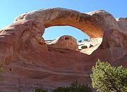
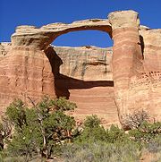
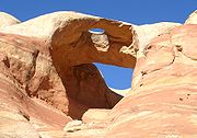
contains 9 natural arch
Natural arch
A natural arch or natural bridge is a natural geological formation where a rock arch forms, with an opening underneath. Most natural arches form as a narrow ridge, walled by cliffs, become narrower from erosion, with a softer rock stratum under the cliff-forming stratum gradually eroding out until...
es, the second highest concentration of such arches in the United States
United States
The United States of America is a federal constitutional republic comprising fifty states and a federal district...
, after the much better known Arches National Park
Arches National Park
Arches National Park is a U.S. National Park in eastern Utah. It is known for preserving over 2000 natural sandstone arches, including the world-famous Delicate Arch, in addition to a variety of unique geological resources and formations....
. Limited access and primitive facilities
limit visitation and help preserve the wilderness in its natural state.
Access to the canyon is either by a strenuous 7 mile hike from the Pollack Bench trailhead or by the Black Ridge
access roads. The latter are reached via the adjacent Colorado National Monument
Colorado National Monument
- Trails :The Monument contains many hiking trails, with lengths and difficulties to suit all tastes. Summer storms can cause flash floods as well as dangerous trail conditions. Rattlesnakes are found on the Monument, and rough terrain exists everywhere, but most trails are well-maintained...
. These dirt road
Dirt road
Dirt road is a common term for an unpaved road made from the native material of the land surface through which it passes, known to highway engineers as subgrade material. Dirt roads are suitable for vehicles; a narrower path for pedestrians, animals, and possibly small vehicles would be called a...
s are open seasonally and should only be attempted in a high ground clearance four wheel drive
Four Wheel Drive
The Four Wheel Drive Auto Company, more often known as Four Wheel Drive or just FWD, was founded in 1909 in Clintonville, Wisconsin, as the Badger Four-Wheel Drive Auto Company by Otto Zachow and William Besserdich.-History:...
vehicle under dry conditions due to steep, rocky grades http://www.co.blm.gov/mcnca/rattlesnakecyn.htm. According to BLM rangers, at least four vehicles were stranded on these roads during the 2006 season after unexpected rains made the roads impassable.2
The arches loop trail starts with steep descent through the first arch and continues past 6 more arches before ascending to join the Pollack Bench trail. An easy trail leads along the cliff top but affords only a limited view of the arches.
Notable features
- Cedar Tree Arch (also known as Rainbow Arch) has a span of 76 feet and an opening height of 43 feet.
- East Rim Arch (also known as Akiti Arch or Centennial Arch) has a span of 40 feet and an opening height of 120 feet.
- Bridge Arch (also known as Hole-in-the-Bridge Arch) has a span of 40 feet and an opening height of 30 feet.
External links
- Hiking Rattlesnake Canyon, BLMBLMBLM may stand for: Saint Barthélemy using ISO 3166-1 alpha-3 country code*Bergbahn Lauterbrunnen-Mürren, a railway in Switzerland, part funicular, part adhesion*Bilayer lipid membrane*Black Mage, a job in Final Fantasy XI...
guidesheet