

Broken Bay
Encyclopedia
Broken Bay is a large inlet of the Pacific Ocean
located about 50 km north of Sydney
on the coast of New South Wales
, Australia
, and is the first major bay north of Sydney
's Port Jackson.
The entrance to Broken Bay lies between the northern Box Head
and Barrenjoey Head
to the south. Barrenjoey Lighthouse was constructed in 1881 to guide ships away from the prominent headland. The bay comprises three arms, being the prominent estuary of the Hawkesbury River
in the west, Pittwater
to the south, and Brisbane Water
to the north. These three arms are flooded rivers
(rias) formed at a time when the sea level
was much lower than it is at the present day.
The Hawkesbury River flows from the confluence of the Grose
and Nepean River
s at the base of the Blue Mountains.
Pittwater
extends south from Broken Bay and is the northernmost extent of the greater Sydney area. Pittwater's calm waters make it a popular sailing area. West Head, west of Barrenjoey Head, marks the divide between Pittwater and the Hawkesbury.
Brisbane Water
is the northern arm of Broken Bay and has the towns of Gosford
and Woy Woy
on its shores.
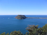
Lion Island, named for its profile's resemblance to a Sphinx
from some viewpoints, is located at the entrance of Broken Bay. Lion Island Nature Reserve covers the entire island, and is home to a colony of fairy penguins
.
Ray Parkin
in his book H. M. Bark Endeavour claims that the modern 'Broken Bay' was passed unremarked at night, and that Cook was in fact referring to the area around Narrabeen Lagoon
.
Matthew Flinders placed Cook's 'Broken Bay' at 33° 42' South, near to the mouth of Narrabeen Lagoon.
Whatever the case, Governor Phillip
was the first to examine the present day Broken Bay in a longboat from the Sirius
on 2 March 1788.
midget submarine
involved in the attack on Sydney Harbour
in 1942 and disappeared soon afterward, was buried under sand on the seabed, just east of Lion Island. Lay claimed to have confirmed that copper wiring found at the site was consistent with that used in similar Japanese vessels. A few weeks later, New South Wales
Planning Minister Frank Sartor
announced that sonar scans conducted by the New South Wales Heritage Office at the location specified had found no trace of the lost submarine.
M-24 was eventually found approximate 13 kilometres south of Broken Bay, 5 kilometres off Bungan Head, proving the hypothesis that M-24 chose to not draw attention to its mother submarines to the south of Sydney Harbour and instead moved north towards Broken Bay.
Pacific Ocean
The Pacific Ocean is the largest of the Earth's oceanic divisions. It extends from the Arctic in the north to the Southern Ocean in the south, bounded by Asia and Australia in the west, and the Americas in the east.At 165.2 million square kilometres in area, this largest division of the World...
located about 50 km north of Sydney
Sydney
Sydney is the most populous city in Australia and the state capital of New South Wales. Sydney is located on Australia's south-east coast of the Tasman Sea. As of June 2010, the greater metropolitan area had an approximate population of 4.6 million people...
on the coast of New South Wales
New South Wales
New South Wales is a state of :Australia, located in the east of the country. It is bordered by Queensland, Victoria and South Australia to the north, south and west respectively. To the east, the state is bordered by the Tasman Sea, which forms part of the Pacific Ocean. New South Wales...
, Australia
Australia
Australia , officially the Commonwealth of Australia, is a country in the Southern Hemisphere comprising the mainland of the Australian continent, the island of Tasmania, and numerous smaller islands in the Indian and Pacific Oceans. It is the world's sixth-largest country by total area...
, and is the first major bay north of Sydney
Sydney
Sydney is the most populous city in Australia and the state capital of New South Wales. Sydney is located on Australia's south-east coast of the Tasman Sea. As of June 2010, the greater metropolitan area had an approximate population of 4.6 million people...
's Port Jackson.
Geography
The entrance to Broken Bay lies between the northern Box Head
Box Head, New South Wales
Box Head is a coastal suburb of the Central Coast region of New South Wales, Australia, located within the City of Gosford local government area....
and Barrenjoey Head
Barrenjoey, New South Wales
Barrenjoey is a locality in the suburb of Palm Beach, at the farthest northern tip of Pittwater. The headland is mostly made up of Hawkesbury sandstone which overlays Narrabeen shale. Around 10,000 years ago the headland was cutoff from the mainland due to the rising sea level; subsequent buildup...
to the south. Barrenjoey Lighthouse was constructed in 1881 to guide ships away from the prominent headland. The bay comprises three arms, being the prominent estuary of the Hawkesbury River
Hawkesbury River
The Hawkesbury River, also known as Deerubbun, is one of the major rivers of the coastal region of New South Wales, Australia. The Hawkesbury River and its tributaries virtually encircle the metropolitan region of Sydney.-Geography:-Course:...
in the west, Pittwater
Pittwater
Pittwater is a body of water extending south from Broken Bay, New South Wales, Australia parallel to the coast.The waterway was surveyed by crew members of HMS Sirius in 1788, and named Pitt Water after British Prime Minister William Pitt the Younger...
to the south, and Brisbane Water
Brisbane Water
Brisbane Water is the northern arm of Broken Bay on the east coast of New South Wales Australia. Brisbane Water is named after Sir Thomas Brisbane, Governor of New South Wales between 1820 and 1825...
to the north. These three arms are flooded rivers
Ria
A ria is a coastal inlet formed by the partial submergence of an unglaciated river valley. It is a drowned river valley that remains open to the sea. Typically, rias have a dendritic, treelike outline although they can be straight and without significant branches. This pattern is inherited from the...
(rias) formed at a time when the sea level
Sea level
Mean sea level is a measure of the average height of the ocean's surface ; used as a standard in reckoning land elevation...
was much lower than it is at the present day.
The Hawkesbury River flows from the confluence of the Grose
Grose River
The Grose Valley is a rugged valley in the Blue Mountains, New South Wales, Australia. It has been formed by the Grose River, the headwaters of which are in the Mount Victoria area...
and Nepean River
Nepean River
The Nepean River is a river in the coastal region of New South Wales, Australia.The headwaters of the Nepean River rise near Robertson, about 100 kilometres south of Sydney and about 15 kilometres from the coast. The river flows north in an unpopulated water catchment area into Nepean Dam, which...
s at the base of the Blue Mountains.
Pittwater
Pittwater
Pittwater is a body of water extending south from Broken Bay, New South Wales, Australia parallel to the coast.The waterway was surveyed by crew members of HMS Sirius in 1788, and named Pitt Water after British Prime Minister William Pitt the Younger...
extends south from Broken Bay and is the northernmost extent of the greater Sydney area. Pittwater's calm waters make it a popular sailing area. West Head, west of Barrenjoey Head, marks the divide between Pittwater and the Hawkesbury.
Brisbane Water
Brisbane Water
Brisbane Water is the northern arm of Broken Bay on the east coast of New South Wales Australia. Brisbane Water is named after Sir Thomas Brisbane, Governor of New South Wales between 1820 and 1825...
is the northern arm of Broken Bay and has the towns of Gosford
Gosford, New South Wales
Gosford is a city located on the Central Coast of New South Wales, Australia, approximately 76 km north of the Sydney central business district...
and Woy Woy
Woy Woy, New South Wales
Woy Woy is a coastal town and a southern suburb of the Central Coast region of New South Wales, Australia, located on the southern reaches of Brisbane Water north of Sydney...
on its shores.
Lion Island, named for its profile's resemblance to a Sphinx
Sphinx
A sphinx is a mythical creature with a lion's body and a human head or a cat head.The sphinx, in Greek tradition, has the haunches of a lion, the wings of a great bird, and the face of a woman. She is mythicised as treacherous and merciless...
from some viewpoints, is located at the entrance of Broken Bay. Lion Island Nature Reserve covers the entire island, and is home to a colony of fairy penguins
Little Penguin
The Little Penguin is the smallest species of penguin. The penguin, which usually grows to an average of in height and in length , is found on the coastlines of southern Australia and New Zealand, with possible records from Chile.Apart from Little Penguins, they have several common names...
.
European Discovery
James Cook recorded "broken land" seen north of Port Jackson just before sunset on 7 May 1770, and named it Broken Bay. However, there has been some controversy over whether what is now known as 'Broken Bay' was what was sighted by Cook.- Matthew FlindersMatthew FlindersCaptain Matthew Flinders RN was one of the most successful navigators and cartographers of his age. In a career that spanned just over twenty years, he sailed with Captain William Bligh, circumnavigated Australia and encouraged the use of that name for the continent, which had previously been...
, The colonists have called this place Broken Bay, but it is not what was so named by Captain Cook.
Ray Parkin
Ray Parkin
Ray Parkin was an Australian writer, amateur artist, and self-taught historian, noted for his memoirs of World War II and a major work on Captain Cook's Endeavour voyage.-Early life:...
in his book H. M. Bark Endeavour claims that the modern 'Broken Bay' was passed unremarked at night, and that Cook was in fact referring to the area around Narrabeen Lagoon
Narrabeen, New South Wales
Narrabeen is a beachside suburb in northern Sydney, in the state of New South Wales, Australia. Narrabeen is located 23 kilometres north-east of the Sydney central business district, in the local government area of Warringah Council and is part of the Northern Beaches region.-History:There are a...
.
Matthew Flinders placed Cook's 'Broken Bay' at 33° 42' South, near to the mouth of Narrabeen Lagoon.
Whatever the case, Governor Phillip
Arthur Phillip
Admiral Arthur Phillip RN was a British admiral and colonial administrator. Phillip was appointed Governor of New South Wales, the first European colony on the Australian continent, and was the founder of the settlement which is now the city of Sydney.-Early life and naval career:Arthur Phillip...
was the first to examine the present day Broken Bay in a longboat from the Sirius
HMS Sirius (1786)
HMS Sirius was the flagship of the First Fleet, which set out from Portsmouth, England, in 1787 to establish the first European colony in New South Wales, Australia. Sirius was wrecked off the coast of Norfolk Island in the Pacific Ocean in 1790....
on 2 March 1788.
Role in attack on Sydney Harbour
On 28 November 2005, documentary film-maker Damien Lay claimed that the wreckage of M-24, a JapaneseEmpire of Japan
The Empire of Japan is the name of the state of Japan that existed from the Meiji Restoration on 3 January 1868 to the enactment of the post-World War II Constitution of...
midget submarine
Midget submarine
A midget submarine is any submarine under 150 tons, typically operated by a crew of one or two but sometimes up to 6 or 8, with little or no on-board living accommodation...
involved in the attack on Sydney Harbour
Attack on Sydney Harbour
In late May and early June 1942, during World War II, submarines belonging to the Imperial Japanese Navy made a series of attacks on the cities of Sydney and Newcastle in New South Wales, Australia...
in 1942 and disappeared soon afterward, was buried under sand on the seabed, just east of Lion Island. Lay claimed to have confirmed that copper wiring found at the site was consistent with that used in similar Japanese vessels. A few weeks later, New South Wales
New South Wales
New South Wales is a state of :Australia, located in the east of the country. It is bordered by Queensland, Victoria and South Australia to the north, south and west respectively. To the east, the state is bordered by the Tasman Sea, which forms part of the Pacific Ocean. New South Wales...
Planning Minister Frank Sartor
Frank Sartor
Francesco Ernest 'Frank' Sartor JP a former Australian politician, was New South Wales Minister for Climate Change and the Environment and Minister Assisting the Minister for Health between 2009 and 2011. He was a Member of the New South Wales Legislative Assembly representing Rockdale for the...
announced that sonar scans conducted by the New South Wales Heritage Office at the location specified had found no trace of the lost submarine.
M-24 was eventually found approximate 13 kilometres south of Broken Bay, 5 kilometres off Bungan Head, proving the hypothesis that M-24 chose to not draw attention to its mother submarines to the south of Sydney Harbour and instead moved north towards Broken Bay.