
Beeston, Nottinghamshire
Encyclopedia
Beeston is a town in Nottinghamshire
, England
. It is 5.5 kilometres (3.4 mi) southwest of Nottingham
city centre. Although typically regarded as a suburb
of the City of Nottingham, and officially designated as part of the Nottingham Urban Area, for local government purposes it is in the borough
of Broxtowe
, lying outside the City's unitary authority area.
To the immediate northeast is the University of Nottingham
's main campus, University Park. The pharmaceutical and retail chemist group Boots
has its headquarters on a large campus just 1 km east of the centre of Beeston, falling on the border of Broxtowe and the City of Nottingham. To the south is the River Trent
, Attenborough
and its extensive wetlands.
to the west, and Wollaton
and Lenton Abbey
to the north; Beeston is to a degree separated from Bramcote
to the northwest by the Beeston Fields Golf Course. The Broxtowe-City of Nottingham border runs immediately to the east of the town and this essentially forms the town's eastern edge. There are two main areas of the town; north of the railway line (the Midland Main Line
) lies the main part, including the main shopping district, whilst south of the line lies the mixed housing and industrial area of Beeston Rylands.
to the south, and this has meant that property here was less desirable, and led to more modestly sized houses being constructed, originally mostly for rental. The last serious flood was in 1947 and reached far beyond the railway line, most of Queens Road was flooded as was Nether Street. The construction of strengthened flood protection has reduced the flooding threat to Beeston Rylands to a one every fifty year possibility. A £51 million series of flood defence improvements, designed to reduce incidents to once every hundred years, along a 27 km stretch of the Trent, began construction in 2009.
. Although most of the University is within the City of Nottingham boundaries, around half of the student self-catering flats of Broadgate Park
, owned by private company UPP, fall within the Broxtowe side of the border and therefore Beeston. Nearer to the town centre is the self-catering Albion House, which is also owned by UPP and is associated with their main Broadgate Park site. The town also has a large population of postgraduate students, who tend to prefer its quieter atmosphere to that of the Nottingham areas of Dunkirk
and Lenton
where many undergraduates live. Through the main University Park campus runs Beeston Lane.
for local government/electoral purposes within Broxtowe: Beeston North, Beeston Central, Beeston Rylands, and Beeston West. The Rylands ward is considerably larger by area than the other three wards of Beeston, as it includes unpopulated floodplain
of the River Trent and industrial areas, including the part of the Boots Estate that falls within Broxtowe; the Rylands ward also extends north of the railway line in the west, up to Queen's Road and includes the former site of Nottingham Rugby Club. To the west of Rylands is the Attenborough
ward; to the west of Beeston West is the Chilwell East ward. Beeston's town centre largely falls across the wards of West and Central. The North ward includes some residential estates north of the A52 Derby Road, including a very small part of the Wollaton urban area that falls within Broxtowe; to the west of this ward is Bramcote Hills
and the Bramcote ward.
The ward boundaries of Broxtowe were reviewed in 2000 and resulted in two notable changes to Beeston's western boundary. In the northwest of the town Beeston Cemetery and the residential streets immediately surrounding it (south of Derby Road), such as Coniston Road and Windermere Road, as well as the Nuseryman pub and the eastern part of Beeston Fields Golf Course, were transferred to the Bramcote ward. Beeston however gained some territory from Chilwell, including residential streets, such as Park Road, Grove Avenue and Cumberland Avenue, as well as Castle College and the small industrial area between Holly Lane and Wilmot Lane. The original boundary between the old Beeston and Chilwell parish
es can still be identified by the change in road name from Chilwell Road (on the Beeston side) to High Road (on the Chilwell side) where the Hop Pole pub is. The original Beeston-Bramcote boundary is also still marked on the A52 Derby Road.
the Liberal Democrats
won all seats in the North and West wards, whilst Labour
won all seats in the Central and Rylands wards. The next elections to Broxtowe Borough Council will be held in 2011
. For elections to Nottinghamshire County Council the town is covered by two electoral divisions: Beeston North (consisting of the North and West wards) and Beeston South & Attenborough (consisting of the Central, Rylands and Attenborough wards). Each division returns one county councillor and the most recent county council elections were held in 2009
— the Liberal Democrats won Beeston North and the Conservatives
won Beeston South & Attenborough.
For elections to Parliament
the town is part of the Broxtowe constituency
. From 1974 to 1983 a Beeston constituency
existed. The present Member of Parliament
is Anna Soubry
of the Conservative party, who won the seat from the Labour party at the 2010 general election.
and has no town council, however it was a civil parish until 1935. The area of the parish was reduced slightly in 1933, with some parcels of land in the east transferred to the City of Nottingham; boundary posts were erected on the new Beeston-Nottingham boundary and many of these are still in place today, with "1933" marked on them. The present four wards which constitute Beeston today cover the same post-1933 area of the old parish, with the two recent alterations made to the western boundary, as described in the "Wards" section above.
From 1935 until 1974 (when the borough of Broxtowe was formed) Beeston was paired with the town of Stapleford
(2 km to the west) in the Beeston and Stapleford
urban district
. Previously a Beeston Urban District
existed, covering the Beeston parish. The town was the administrative centre of Beeston and Stapleford Urban District Council and is the administrative centre for Broxtowe Borough Council, which have their head offices on Foster Avenue at Beeston Town Hall and the other council buildings situated there.
 In the late nineteenth century, a genteel convention was contrived that the town's name derived from bee
. This would have also been consistent with the notion of Beeston as a "hive of industry". The bee was adopted as the emblem
of the town council. Beehives appear carved in the brick of the town hall exterior, and in 1959 three bees were included in the coat of arms
adopted by Beeston and Stapleford
Urban District Council. However, as this derivation was known to be dubious, the College of Arms
subtly included some long grasses entwined with meadow crocuses in the arms as an alternative visual pun
on the more likely origins of the name. With the formation of Broxtowe District (later Borough) Council in 1974, the bees were carried on to its coat of arms, representing Beeston. The tradition of the bee as symbol continues - the litter bins and other street furniture in the High Road are decorated in black and gold, with a symbol of a bee on each.
There is also a sculpture on the High Road of a man sitting next to a bee hive. Again, this is another reference to the "Bee". The sculpture is popularly known as the "Bee-man", "the man of Beeston", "The Beekeeper" or "Bee King".
s of land assessed, which was taken from them, and given to William Peverel, the lord of Nottingham Castle, who had in his demesne
, or chief manor estate, 2 plough teams, there being 17 bond tenants, called villeins, who where unable to leave the estate without the lord's consent, and yet each cultivating, say, 15 acres (60,702.9 m²) of arable land, and 1 ordinary tenant, called a sochman, who together had 9 plough teams. There were 24 acres (97,124.6 m²) of meadow, and the annual value of the estate was 30/–.
 Beeston grew from its village status with its development as a silk weaving centre in the early nineteenth century. The first silk mill was burned down (along with Nottingham Castle
) in the Reform Bill
riots of 1831. With the decline of the silk industry, many of the former mills moved to light industrial uses in the early twentieth century. Equipment produced by the Beeston Boiler Company is still to be found all around the former British Empire
.

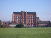
In 1901 the National Telephone Co., Ltd. established a factory there for making telephone material. This was taken over by the British L.M. Ericsson
Manufacturing Co., Ltd., in 1903. Shortly before the transfer, most of the old factory was destroyed by fire, and in the rebuilding it was extended. A new power station was built. In 1906 and 1907 a large new building was erected, chiefly devoted to cabinet work. The old factory building covered an area of 63000 sq ft (5,852.9 m²)., and the cabinet factory 70000 sq ft (6,503.2 m²)., whilst the power station had an area of 7000 sq ft (650.3 m²)., making a total covered space of 140000 sq ft (13,006.4 m²). Although most of the factory buildings were low rise, a Paternoster
lift still survives in E block at the site.
Under the Plessey
name these large premises continued to be a major source of local employment through the 1980s. Plessey became GPT
with GEC
's involvement. With the various restructurings of the GEC
group and its rebranding as Marconi
, a large part of the site was sold to Siemens
along with the private telephone networks side of the business. GPT sublet a substantial part of the site as a "technology park" when they moved most manufacturing overseas. History has now come full circle as the remainder of the site, used for the public telephone networks side of the businesses, is now occupied by the Swedish Ericsson company, following their take-over of Marconi in early 2006.
The whole site was acquired by HSBC
in 2006 for a mixed-use "employment-led" redevelopment, although it is not clear which tenant companies will remain.
The Boots campus includes some Grade I & II listed modernist buildings, designed by engineer Owen Williams, though they are very difficult to see from any public highway.
Between 1880 and the turn of the century, Thomas Humber
and his partners were making bicycles and eventually motor-cycles and cars at a large factory at the junction of what is now Queens Road and Humber Road. At its height it employed 2000 although this came to an abrupt end in 1907 when the company moved all operations to Coventry.
Motor manufacture returned to Beeston for a short period in 1987 when The Middlebridge Company set up a small factory on Lilac Grove and produced 77 Scimitar
cars. The company went into liquidation in 1990.
 Beeston Maltings was in operation until the late 20th century. The buildings are on Dovecote Lane opposite the Victoria Hotel, but as of 2007 are scheduled for demolition to make way for housing.
Other wide-reaching local companies include metalworking lathe
manufacturer Myford
and the internet firm Webfusion (later Hosteurope and then part of PIPEX Communications
).
Road was turnpiked
in 1758–1759, and dis-turnpiked in 1870. A branch of the Nottingham and Ashby
Turnpike Road, usually called the Sawley branch, went through Beeston. In 1831 an advertisement of the four-horse coach from Nottingham to Birmingham
states that the coach called at Beeston daily at 8.30 am, and in the opposite direction at 3.30 pm.
In the present, the modern-day Nottingham–Derby road — the A52
— passes through the very northern part of the town; Junction 25 of the M1 motorway
approximately 6.4 kilometres (4 mi) away (via the A52). The A6005 road runs through the town, to the southeast of the town centre, as do the B6006 and B6464 routes which pass through the heart of Beeston. The town centre has a number of municipal car parks, owned by Broxtowe Borough Council, as well as the supermarket car parks. The road that runs between the town centre of Beeston and University Park is called Broadgate (and is part of the B6464).
from Trent Bridge
to Langley Mill
, via Nottingham and Lenton
had been authorised in 1790 and was completed by 1802. This meant that valuable goods traffic from the Erewash valley could bypass the River Erewash
and River Trent
. In response, the Beeston Canal was promoted by the Trent Navigation Company
under an Act passed in 1794. This was a branch canal from Beeston Cut to Lenton chain where it met the Nottingham Canal. This involved the necessity for the weir at Beeston Rylands to maintain the water level to supply the canal through to Trent Bridge
. Originally there was a second lock at Beeston Cut to allow small vessels to enter the Trent below the weir, but this was abandoned c. 1940.
 The Midland Counties Railway
from Nottingham to Derby
through Beeston was opened on 30 May 1839. This later became part of the London, Midland and Scottish Railway
company and then London Midland Region (British Railways).
Today Beeston has good rail transport links with Beeston station
, on the Midland Main Line
, served by East Midlands Trains
and Arriva Cross Country. Direct trains to and from London St Pancras
call at Beeston, on an hourly frequency each way, with journey times to/from the capital being typically just under 2 hours. The distance (by rail) to St Pancras is 123 miles (197.9 km).
There are also regular, direct services to Nottingham, Derby
, Lincoln
, Bedford
, Burton upon Trent
, Leicester
, Loughborough
, Tamworth
(for WCML), Newark
(Castle), Luton
, East Midlands Parkway
(for the Airport), Birmingham
(New Street) and Matlock. Direct trains to Gloucester
and Cardiff
exist (Monday-Saturday) in the morning and from those cities in the evening. There is also a direct train to Bournemouth
at 06:43 Monday-Saturday.
, Loughborough
and other local towns, operated primarily by Trent Barton
and Nottingham City Transport
. Beeston has a bus station
located just off Station Road in the town centre.
Nottingham City Transport
Trent Barton
Premiere Travel
YourBus
) line through the town as part of an extension to the Nottingham Express Transit
system were approved by the Government in 2009. The line would run from Nottingham city centre to Beeston and then Chilwell. From a stop at University Boulevard, the line would head along Fletcher Road and Lower Road to a stop at Middle Street, then continue along Middle Street to a "Beeston Town Centre" stop near the existing bus station. After the Town Centre stop the line would continue roughly westwards on Chilwell Road to stops at Chilwell Road and then Castle College. After the college the line would continue through Chilwell and onto the terminus stop, a park and ride
site called "Toton Lane", situated between Toton and Stapleford.
A motivation is the traffic jams on local roads during rush hour periods. There has been some opposition to the scheme by local traders and those along the proposed route, who have stated that they fear that during the construction work, business would likely be adversely affected and that the scheme is being imposed without concern for locals. However, a survey in 2004 by Nottingham Express Transit showed strong local support for the scheme.
A circular route called 'The Big Track' is used by Cyclists and Pedestrians, it follows towpaths along most of the Nottingham Urban sections of River Trent and the entirety of Beeston Canal
Numerous other cycle routes through Beeston have also been signposted by the council.
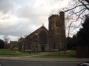
 Beeston has a number of historic buildings, including its manor house and parish church of St. John the Baptist
. The church dates from the 11th century but was largely rebuilt in 1843 by Sir George Gilbert Scott
. Both are included in the West End conservation area
which includes a considerable number of buildings, many historical or of character, along the streets of Dovecote Lane, Grange Avenue, West End, and Church Street. Also included in the area is the historic Village Cross.
Information on Beeston Parish Church on the Southwell Diocesan History Project website
An act was passed for enclosing lands in the parish of Beeston, and in 1809 the Commissioners stated that the lands amounted to 822 acres (3.3 km²), to be made tithe free, and the ancient enclosed lands and homesteads liable to tithe was £687 2s 29d. They then proceeded to fix the width of the roads. The Nottingham and Derby turnpike road was fixed at 50 feet (15.2 m). Wollaton road, then called Cowgate, was 30 feet (9.1 m). The Inclosure not only altered the appearance of part of the parish from a moor growing poor grass, to cultivated fields with hedges, and thereby increasing the food supply, but it relieved farmers from the annoyance of having to hand over the tenth of their product in kind.
Some lands on or near Bramcote Moor, but in Beeston parish, were enclosed in 1847, by provisional order of the Inclosure Commissioners.
Before the introduction of gas generally in the parish there was a limited supply from the Mill to separate houses. The Church was first lit with gas in 1857. The Public Lighting Act was adopted at a Vestry Meeting on 13 November 1862. The opposition to lamps in the streets was strong, and the effigy of an active promoter of it was carried on an ass round the village and hung on a lamp-post, and but for police interference would have been burned. In 1861 gas was supplied from Nottingham by the Nottingham Gas Light and Coke Company, and for street lamps in 1872. Beeston was connected to the mains water supply in 1876.
 The crenellated listed building of the Anglo-Scotian Mills remains on Wollaton Road to the north of the town centre. It is a solitary reminder of the former dominance of silk and lace mills on the local skyline. The buildings have been converted into a series of apartments that are currently for sale by their developer.
A cottage on the north side of Anglo-Scotian Mills was reputed to have the tallest domestic chimney in England. Its length was necessary to reach over the roof of the Mill. Although the cottage has been demolished for several years, the chimney can still be seen attached to the wall of the Mill.
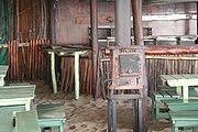
A rare survival is the G H Hurt & Son Shawl Factory, which is occasionally open to the public. Shawls are produced on knitting machines and hand finished in much the same way as they have been for centuries. The factory contains examples of knitting frames from the 17th century.
Lost industrial buildings include the rebuilt silk mill and the looming bulk of the Neville Works mill on the boundary with Chilwell (later occupied by the Myford lathe factory).
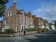
by the Beeston Land Society, a group of citizens, who divided the land out into 28 plots of between three-quarters and 1 acres (4,046.9 m²) and set out the wide straight streets. The majority of the houses are of Edwardian and late Victorian origin. The Land Society set conditions for the developers including no public houses, and strict building lines which ensured that properties were set back a consistent distance from the road. The St. John's Grove Estate is now a conservation area.
, was originally promoted by the Labourer's Friend Society
in the 1840s as plots for cottages with allotments for the labouring poor. This scheme failed and the area now consists mostly of Victorian and Edwardian houses laid out along the parallel Park Road and Grove Avenue and the two short cross streets Cedar Road and North Drive. The area retains a leafy character and the roads remain unkerbed, and has been a conservation area since 2008.
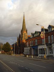
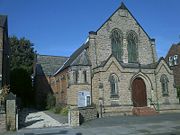 A particularly fine Methodist Church was constructed by the architect W.J. Morley of Bradford on Chilwell Road in 1902. Its landmark spire is now visible from afar since the demolition of several large mill buildings in the 1990s. The front of the building is floodlit at night, contributing to local light pollution
.
Rylands was originally a small settlement around Beeston Lock, comprising some tens of houses and two pubs, although the name now refers to all of the area south of the railway line. The Jolly Angler was originally on the river side of the canal, but has since moved. Beeston began to spread south of the railway line in the late 19th century when a few Victorian villas were built near the level crossing by the station. Over the first few decades of the 20th century, several estates were built to house the workers at Ericssons and Boots, both of which had large factory sites also south of the railway line, and these estates joined Beeston and Rylands. Further post-WWII development filled in the gaps, initially with an estate of council houses and flats, and latterly with private houses and bungalows. The last significant development was in 1970 of Meadow Farm, now the four roads of timber-framed semi-detached houses between Beech Avenue and the canal. Since then Beeston Rylands has had only a small amount of infill development.
moved from the centre of Nottingham to their current location on Derby Road in Beeston during the 1950s.
 Beeston's main shopping area is situated along the High Road, much of which has been pedestrianised. There are some chain stores in Beeston, but the town is best-known for its selection of high-quality independent stores including specialist east Asian and Mediterranean food shops.
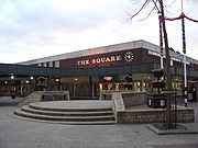
There are also large numbers of takeaways and several restaurants, offering a wide selection of food including Chinese, Thai, and Indian cuisine. Many cafés are to be found around the main shopping centre, "The Square"—the centre of Beeston—is a 1960s shopping development, most of which is pedestrianised. A £1.4-million environmental improvement scheme covered pavements and lighting for the non-pedestrianised eastern end of the High Street. Further east Broadgate saw improvements, with a new space at the top entrance to Broadgate Recreation Ground. The works were completed in late 2006.
The shopping centre is cut in two by Wollaton Road which has a very high volume of traffic. The lighting installed at the time of a 1980s refurbishment of the square contributes to local light pollution
. A large area south east of the shopping centre has made room for a Tesco
superstore, which opened 1 November 2010, rivalling the Sainsbury's store located in the town centre and the recently built Lidl
store on Wollaton Road to the north of the town centre. Beeston Fire Station on an adjacent plot has been closed and relocated to a new site on Hassocks Lane.
 Beeston is known for the variety of its traditional public house
s and has one of the highest concentrations of pubs-per-person in the United Kingdom with 23 pubs (as of 2011) within as per the Beeston Crawl.
The Victoria Hotel, a Victorian
railway hotel and pub adjacent to the railway station, has received several local awards, including "Nottinghamshire Dining Pub of the Year" – Good Pub Guide 2002, and runner-up for The Times
– "Pub of the Year", 2000.
The Victoria Hotel and the Malt Shovel, on Union Street, both appear in the 2010 and 2011 editions of the CAMRA
Good Beer Guide
. The Crown, a listed building on Church Street, in the West End conservation area, was awarded the Nottingham, then the Nottinghamshire and then the East Midlands
CAMRA "Pub of the Year" 2010 awards and now appears in the 2011 edition of the Guide. There is a Wetherspoon's chain pub called The Last Post, situated in the building of the old Royal Mail sorting office and still adjacent to the town's main post office.
In the southeast of the town, on Factory Lane, a small brewery
— called Reality — began producing real ale in 2010, with a 2.5 barrel plant.
s — the main one is on Chilwell Road (on a site that was once also the town's delivery office), another exists in the town centre on High Road (towards Broadgate), and a third on Central Avenue in the northern part of the town. A fourth post office did exist in the Rylands part of town, but was closed in January 2008 as part of a wider review.
The Royal Mail
's main sorting office
for the Nottingham area (the NG postcode area) is sited on the eastern edge of the town at Padge Road, with the City of Nottingham boundary running around the building. It was built in 1995 and includes the new delivery office for handling the local distribution of Beeston's mail.
who play at Highfields Sports Club on University Boulevard.
Until 2006, Beeston was home to Nottingham Rugby Club
, which sold the land next to the railway line (now the Birkin Fields housing development) and moved to share the Meadow Lane
pitch at the Notts County ground. Nottingham Casuals Rugby Club still play on the rugby pitches at Weirfields near the canal.
Two golf course
s exist adjacent to the town: Beeston Fields and Chilwell Manor. A short distance to the north is Bramcote Hill
Golf Club and to the northeast the golf course at Wollaton Park.
Beeston is also home to several well established football clubs, including Beeston Town FC who play their home games at Highfields and compete in Division One of the Long Eaton Sunday League.
plant at Beeston Rylands Weir. The plant was commissioned on 4 January 2000 and later sold on to United Utilities
in 2001. The plant has a design life of twenty years. At the maximum consented flow rate, 60 m3/s of water passes through the pair of turbines. Upstream of the weir and during the salmon migratory period, the plant utilises a bio-acoustic fish-fence—a bubble curtain
in which the bubbles contain a sound that the fish do not like. This fish fence steers migrating fish away from the fast-flowing turbine intakes and into the fish ladder
, by which the fish can safely negotiate the weir. The power generated supplies enough electricity (1.5 MW–1.66 MW) for two thousand homes, a total of 5.26 GWh annually.
Nottinghamshire
Nottinghamshire is a county in the East Midlands of England, bordering South Yorkshire to the north-west, Lincolnshire to the east, Leicestershire to the south, and Derbyshire to the west...
, England
England
England is a country that is part of the United Kingdom. It shares land borders with Scotland to the north and Wales to the west; the Irish Sea is to the north west, the Celtic Sea to the south west, with the North Sea to the east and the English Channel to the south separating it from continental...
. It is 5.5 kilometres (3.4 mi) southwest of Nottingham
Nottingham
Nottingham is a city and unitary authority in the East Midlands of England. It is located in the ceremonial county of Nottinghamshire and represents one of eight members of the English Core Cities Group...
city centre. Although typically regarded as a suburb
Suburb
The word suburb mostly refers to a residential area, either existing as part of a city or as a separate residential community within commuting distance of a city . Some suburbs have a degree of administrative autonomy, and most have lower population density than inner city neighborhoods...
of the City of Nottingham, and officially designated as part of the Nottingham Urban Area, for local government purposes it is in the borough
Borough status in the United Kingdom
Borough status in the United Kingdom is granted by royal charter to local government districts in England, Wales and Northern Ireland. The status is purely honorary, and does not give any additional powers to the council or inhabitants of the district...
of Broxtowe
Broxtowe
Broxtowe is a local government district with borough status in Nottinghamshire, England, west of the City of Nottingham. It is part of the Greater Nottingham metropolitan area...
, lying outside the City's unitary authority area.
To the immediate northeast is the University of Nottingham
University of Nottingham
The University of Nottingham is a public research university based in Nottingham, United Kingdom, with further campuses in Ningbo, China and Kuala Lumpur, Malaysia...
's main campus, University Park. The pharmaceutical and retail chemist group Boots
Boots UK
Boots UK Limited , is a leading pharmacy chain in the United Kingdom, with outlets in most high streets throughout the country...
has its headquarters on a large campus just 1 km east of the centre of Beeston, falling on the border of Broxtowe and the City of Nottingham. To the south is the River Trent
River Trent
The River Trent is one of the major rivers of England. Its source is in Staffordshire on the southern edge of Biddulph Moor. It flows through the Midlands until it joins the River Ouse at Trent Falls to form the Humber Estuary, which empties into the North Sea below Hull and Immingham.The Trent...
, Attenborough
Attenborough, Nottinghamshire
Attenborough is a village and a suburb in the Broxtowe borough of Nottinghamshire. It forms part of Greater Nottingham, and is to the southwest of Nottingham, between Long Eaton and Beeston...
and its extensive wetlands.
Geography
Suburban development of the mid-twentieth century means that the built up area of Beeston is now continuous with the former villages of ChilwellChilwell
Chilwell is a residential suburb of Greater Nottingham, in the Borough of Broxtowe of Nottinghamshire, west of Nottingham city. Until 1974 it was part of Beeston and Stapleford Urban District, having been in Stapleford Rural District until 1935.-History:...
to the west, and Wollaton
Wollaton
Wollaton is an area in the western part of Nottingham, England. It is home to Wollaton Hall with its museum, deer park, lake, walks and golf course...
and Lenton Abbey
Lenton Abbey
Lenton Abbey is a location in Nottingham, in the Wollaton East and Lenton Abbey ward of Nottingham City Council.Lenton Abbey adjoins Wollaton, Beeston and the University of Nottingham.There is a Church of England church St. Barnabas' Church, Lenton Abbey....
to the north; Beeston is to a degree separated from Bramcote
Bramcote
Bramcote is a settlement in the Broxtowe district of Nottinghamshire, about five miles west of Nottingham. It was a separate village but is now a suburb of Greater Nottingham. Originally one of the main roads between the cities of Nottingham and Derby passed through the village centre...
to the northwest by the Beeston Fields Golf Course. The Broxtowe-City of Nottingham border runs immediately to the east of the town and this essentially forms the town's eastern edge. There are two main areas of the town; north of the railway line (the Midland Main Line
Midland Main Line
The Midland Main Line is a major railway route in the United Kingdom, part of the British railway system.The present-day line links London St...
) lies the main part, including the main shopping district, whilst south of the line lies the mixed housing and industrial area of Beeston Rylands.
Rylands
Rylands was historically more at risk of flooding from the River TrentRiver Trent
The River Trent is one of the major rivers of England. Its source is in Staffordshire on the southern edge of Biddulph Moor. It flows through the Midlands until it joins the River Ouse at Trent Falls to form the Humber Estuary, which empties into the North Sea below Hull and Immingham.The Trent...
to the south, and this has meant that property here was less desirable, and led to more modestly sized houses being constructed, originally mostly for rental. The last serious flood was in 1947 and reached far beyond the railway line, most of Queens Road was flooded as was Nether Street. The construction of strengthened flood protection has reduced the flooding threat to Beeston Rylands to a one every fifty year possibility. A £51 million series of flood defence improvements, designed to reduce incidents to once every hundred years, along a 27 km stretch of the Trent, began construction in 2009.
University of Nottingham
The eastern edge of Beeston abuts to the main campus of the University of NottinghamUniversity of Nottingham
The University of Nottingham is a public research university based in Nottingham, United Kingdom, with further campuses in Ningbo, China and Kuala Lumpur, Malaysia...
. Although most of the University is within the City of Nottingham boundaries, around half of the student self-catering flats of Broadgate Park
Broadgate Park
Broadgate Park is a self-catered hall of residence at the University of Nottingham for undergraduate and postgraduate students. Housing about 2400 students and containing 2,223 rooms it is one the largest student villages in Europe. It is located outside of the West Entrance of the University Park...
, owned by private company UPP, fall within the Broxtowe side of the border and therefore Beeston. Nearer to the town centre is the self-catering Albion House, which is also owned by UPP and is associated with their main Broadgate Park site. The town also has a large population of postgraduate students, who tend to prefer its quieter atmosphere to that of the Nottingham areas of Dunkirk
Dunkirk, Nottingham
Dunkirk is a residential area of Nottingham, England which is located to the south east of the University of Nottingham and the Queen's Medical Centre...
and Lenton
Lenton, Nottingham
Lenton is an area of the City of Nottingham in the county of Nottinghamshire, England. Politically, it falls within the Nottingham South constituency. Most of the area lies within the electoral ward of "Dunkirk and Lenton", however the "Lenton Triangle" area, considered by most residents to be part...
where many undergraduates live. Through the main University Park campus runs Beeston Lane.
Wards
The town is subdivided into four wardsWards of the United Kingdom
A ward in the United Kingdom is an electoral district at sub-national level represented by one or more councillors. It is the primary unit of British administrative and electoral geography .-England:...
for local government/electoral purposes within Broxtowe: Beeston North, Beeston Central, Beeston Rylands, and Beeston West. The Rylands ward is considerably larger by area than the other three wards of Beeston, as it includes unpopulated floodplain
Floodplain
A floodplain, or flood plain, is a flat or nearly flat land adjacent a stream or river that stretches from the banks of its channel to the base of the enclosing valley walls and experiences flooding during periods of high discharge...
of the River Trent and industrial areas, including the part of the Boots Estate that falls within Broxtowe; the Rylands ward also extends north of the railway line in the west, up to Queen's Road and includes the former site of Nottingham Rugby Club. To the west of Rylands is the Attenborough
Attenborough, Nottinghamshire
Attenborough is a village and a suburb in the Broxtowe borough of Nottinghamshire. It forms part of Greater Nottingham, and is to the southwest of Nottingham, between Long Eaton and Beeston...
ward; to the west of Beeston West is the Chilwell East ward. Beeston's town centre largely falls across the wards of West and Central. The North ward includes some residential estates north of the A52 Derby Road, including a very small part of the Wollaton urban area that falls within Broxtowe; to the west of this ward is Bramcote Hills
Bramcote Hills
Bramcote Hills forms the northern area of the village and Nottingham suburb of Bramcote, Nottinghamshire, built in the 1950s. It is separated from the main part of the village by the A52 Derby Road ....
and the Bramcote ward.
The ward boundaries of Broxtowe were reviewed in 2000 and resulted in two notable changes to Beeston's western boundary. In the northwest of the town Beeston Cemetery and the residential streets immediately surrounding it (south of Derby Road), such as Coniston Road and Windermere Road, as well as the Nuseryman pub and the eastern part of Beeston Fields Golf Course, were transferred to the Bramcote ward. Beeston however gained some territory from Chilwell, including residential streets, such as Park Road, Grove Avenue and Cumberland Avenue, as well as Castle College and the small industrial area between Holly Lane and Wilmot Lane. The original boundary between the old Beeston and Chilwell parish
Parish
A parish is a territorial unit historically under the pastoral care and clerical jurisdiction of one parish priest, who might be assisted in his pastoral duties by a curate or curates - also priests but not the parish priest - from a more or less central parish church with its associated organization...
es can still be identified by the change in road name from Chilwell Road (on the Beeston side) to High Road (on the Chilwell side) where the Hop Pole pub is. The original Beeston-Bramcote boundary is also still marked on the A52 Derby Road.
Elections
The four wards of Beeston each return two councillors to Broxtowe Borough Council. In the 2007 local electionsUnited Kingdom local elections, 2007
The 2007 UK local government elections were held on 3 May 2007. These elections took place in most of England and all of Scotland. There were no local government elections in Wales though the Welsh Assembly had a general election on the same day. There were no local government elections in Northern...
the Liberal Democrats
Liberal Democrats
The Liberal Democrats are a social liberal political party in the United Kingdom which supports constitutional and electoral reform, progressive taxation, wealth taxation, human rights laws, cultural liberalism, banking reform and civil liberties .The party was formed in 1988 by a merger of the...
won all seats in the North and West wards, whilst Labour
Labour Party (UK)
The Labour Party is a centre-left democratic socialist party in the United Kingdom. It surpassed the Liberal Party in general elections during the early 1920s, forming minority governments under Ramsay MacDonald in 1924 and 1929-1931. The party was in a wartime coalition from 1940 to 1945, after...
won all seats in the Central and Rylands wards. The next elections to Broxtowe Borough Council will be held in 2011
United Kingdom local elections, 2011
The 2011 United Kingdom local elections were held on Thursday 5 May 2011. In England, direct elections were held in all 36 Metropolitan boroughs, 194 Second-tier district authorities, 49 unitary authorities and various mayoral posts, meaning local elections took place in all parts of England with...
. For elections to Nottinghamshire County Council the town is covered by two electoral divisions: Beeston North (consisting of the North and West wards) and Beeston South & Attenborough (consisting of the Central, Rylands and Attenborough wards). Each division returns one county councillor and the most recent county council elections were held in 2009
Nottinghamshire Council election, 2009
Elections to Nottinghamshire County Council took place on 4 June 2009, having been delayed from 7 May, in order to coincide with elections to the European Parliament....
— the Liberal Democrats won Beeston North and the Conservatives
Conservative Party (UK)
The Conservative Party, formally the Conservative and Unionist Party, is a centre-right political party in the United Kingdom that adheres to the philosophies of conservatism and British unionism. It is the largest political party in the UK, and is currently the largest single party in the House...
won Beeston South & Attenborough.
For elections to Parliament
Parliament of the United Kingdom
The Parliament of the United Kingdom of Great Britain and Northern Ireland is the supreme legislative body in the United Kingdom, British Crown dependencies and British overseas territories, located in London...
the town is part of the Broxtowe constituency
Broxtowe (UK Parliament constituency)
Broxtowe is a county constituency represented in the House of Commons of the Parliament of the United Kingdom. It elects one Member of Parliament by the first past the post system of election...
. From 1974 to 1983 a Beeston constituency
Beeston (UK Parliament constituency)
Beeston was a parliamentary constituency in Nottinghamshire which returned one Member of Parliament to the House of Commons of the Parliament of the United Kingdom....
existed. The present Member of Parliament
Member of Parliament
A Member of Parliament is a representative of the voters to a :parliament. In many countries with bicameral parliaments, the term applies specifically to members of the lower house, as upper houses often have a different title, such as senate, and thus also have different titles for its members,...
is Anna Soubry
Anna Soubry
Anna Mary Soubry is a British Conservative Party politician who has been the Member of Parliament for Broxtowe since the 2010 general election. She is a single mother of two children....
of the Conservative party, who won the seat from the Labour party at the 2010 general election.
History of local government
Beeston is an unparished areaUnparished area
In England, an unparished area is an area that is not covered by a civil parish. Most urbanised districts of England are either entirely or partly unparished. Many towns and some cities in otherwise rural districts are also unparished areas and therefore no longer have a town council or city...
and has no town council, however it was a civil parish until 1935. The area of the parish was reduced slightly in 1933, with some parcels of land in the east transferred to the City of Nottingham; boundary posts were erected on the new Beeston-Nottingham boundary and many of these are still in place today, with "1933" marked on them. The present four wards which constitute Beeston today cover the same post-1933 area of the old parish, with the two recent alterations made to the western boundary, as described in the "Wards" section above.
From 1935 until 1974 (when the borough of Broxtowe was formed) Beeston was paired with the town of Stapleford
Stapleford, Nottinghamshire
-External links:***...
(2 km to the west) in the Beeston and Stapleford
Beeston and Stapleford
Beeston and Stapleford was an urban district in Nottinghamshire, England, from 1935 to 1974.It was created by a County Review Order. Beeston had previously been part of Beeston Urban District itself, to which was added the entirety of the Stapleford Rural District, consisting of the parishes of...
urban district
Urban district
In the England, Wales and Ireland, an urban district was a type of local government district that covered an urbanised area. Urban districts had an elected Urban District Council , which shared local government responsibilities with a county council....
. Previously a Beeston Urban District
Beeston Urban District
Beeston was an urban district in Nottinghamshire, England, from 1894 to 1935.The urban district was created by the Local Government Act 1894 on the borders of the Beeston Civil Parish and the Beeston Urban Sanitary District...
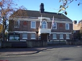
existed, covering the Beeston parish. The town was the administrative centre of Beeston and Stapleford Urban District Council and is the administrative centre for Broxtowe Borough Council, which have their head offices on Foster Avenue at Beeston Town Hall and the other council buildings situated there.
Geographic locale
Origins of the name Beeston
The earliest recorded name given to the area was Bestune. This is now generally thought to be derived from "bes" = rye grass and "tune" a farmstead settlement. The description of local pasture is still preserved in the name of Beeston Rylands. However there are alternative derivations from "Bedestun" = the farm of Bede.Bee
Bees are flying insects closely related to wasps and ants, and are known for their role in pollination and for producing honey and beeswax. Bees are a monophyletic lineage within the superfamily Apoidea, presently classified by the unranked taxon name Anthophila...
. This would have also been consistent with the notion of Beeston as a "hive of industry". The bee was adopted as the emblem
Emblem
An emblem is a pictorial image, abstract or representational, that epitomizes a concept — e.g., a moral truth, or an allegory — or that represents a person, such as a king or saint.-Distinction: emblem and symbol:...
of the town council. Beehives appear carved in the brick of the town hall exterior, and in 1959 three bees were included in the coat of arms
Coat of arms
A coat of arms is a unique heraldic design on a shield or escutcheon or on a surcoat or tabard used to cover and protect armour and to identify the wearer. Thus the term is often stated as "coat-armour", because it was anciently displayed on the front of a coat of cloth...
adopted by Beeston and Stapleford
Beeston and Stapleford
Beeston and Stapleford was an urban district in Nottinghamshire, England, from 1935 to 1974.It was created by a County Review Order. Beeston had previously been part of Beeston Urban District itself, to which was added the entirety of the Stapleford Rural District, consisting of the parishes of...
Urban District Council. However, as this derivation was known to be dubious, the College of Arms
College of Arms
The College of Arms, or Heralds’ College, is an office regulating heraldry and granting new armorial bearings for England, Wales and Northern Ireland...
subtly included some long grasses entwined with meadow crocuses in the arms as an alternative visual pun
Canting arms
Canting arms are heraldic bearings that represent the bearer's name in a visual pun or rebus. The term cant came into the English language from Anglo-Norman cant, meaning song or singing, from Latin cantāre, and English cognates include canticle, chant, accent, incantation and recant.Canting arms –...
on the more likely origins of the name. With the formation of Broxtowe District (later Borough) Council in 1974, the bees were carried on to its coat of arms, representing Beeston. The tradition of the bee as symbol continues - the litter bins and other street furniture in the High Road are decorated in black and gold, with a symbol of a bee on each.
There is also a sculpture on the High Road of a man sitting next to a bee hive. Again, this is another reference to the "Bee". The sculpture is popularly known as the "Bee-man", "the man of Beeston", "The Beekeeper" or "Bee King".
Domesday
In Bestune, at the Conquest, Alfag, Alwine, and UIchel, the Saxons had three manors consisting of three carucateCarucate
The carucate or ploughland was a unit of assessment for tax used in most Danelaw counties of England, and is found for example in Domesday Book. The carucate was based on the area a plough team of eight oxen could till in a single annual season...
s of land assessed, which was taken from them, and given to William Peverel, the lord of Nottingham Castle, who had in his demesne
Demesne
In the feudal system the demesne was all the land, not necessarily all contiguous to the manor house, which was retained by a lord of the manor for his own use and support, under his own management, as distinguished from land sub-enfeoffed by him to others as sub-tenants...
, or chief manor estate, 2 plough teams, there being 17 bond tenants, called villeins, who where unable to leave the estate without the lord's consent, and yet each cultivating, say, 15 acres (60,702.9 m²) of arable land, and 1 ordinary tenant, called a sochman, who together had 9 plough teams. There were 24 acres (97,124.6 m²) of meadow, and the annual value of the estate was 30/–.
More recent history
Nottingham Castle
Nottingham Castle is a castle in Nottingham, England. It is located in a commanding position on a natural promontory known as "'Castle Rock'", with cliffs high to the south and west. In the Middle Ages it was a major royal fortress and occasional royal residence...
) in the Reform Bill
Reform Act 1832
The Representation of the People Act 1832 was an Act of Parliament that introduced wide-ranging changes to the electoral system of England and Wales...
riots of 1831. With the decline of the silk industry, many of the former mills moved to light industrial uses in the early twentieth century. Equipment produced by the Beeston Boiler Company is still to be found all around the former British Empire
British Empire
The British Empire comprised the dominions, colonies, protectorates, mandates and other territories ruled or administered by the United Kingdom. It originated with the overseas colonies and trading posts established by England in the late 16th and early 17th centuries. At its height, it was the...
.
In 1901 the National Telephone Co., Ltd. established a factory there for making telephone material. This was taken over by the British L.M. Ericsson
Ericsson
Ericsson , one of Sweden's largest companies, is a provider of telecommunication and data communication systems, and related services, covering a range of technologies, including especially mobile networks...
Manufacturing Co., Ltd., in 1903. Shortly before the transfer, most of the old factory was destroyed by fire, and in the rebuilding it was extended. A new power station was built. In 1906 and 1907 a large new building was erected, chiefly devoted to cabinet work. The old factory building covered an area of 63000 sq ft (5,852.9 m²)., and the cabinet factory 70000 sq ft (6,503.2 m²)., whilst the power station had an area of 7000 sq ft (650.3 m²)., making a total covered space of 140000 sq ft (13,006.4 m²). Although most of the factory buildings were low rise, a Paternoster
Paternoster
A paternoster or paternoster lift is a passenger elevator which consists of a chain of open compartments that move slowly in a loop up and down inside a building without stopping. Passengers can step on or off at any floor they like...
lift still survives in E block at the site.
Under the Plessey
Plessey
The Plessey Company plc was a British-based international electronics, defence and telecommunications company. It originated in 1917, growing and diversifying into electronics. It expanded after the second world war by acquisition of companies and formed overseas companies...
name these large premises continued to be a major source of local employment through the 1980s. Plessey became GPT
GPT
-Biology:* Alanine transaminase or Glutamate Pyruvate Transaminase, an enzyme useful in a blood test* Xanthine-guanine phosphoribosyl-transferase, an enzyme in purine metabolism-Technology:...
with GEC
GEC
The three-letter acronym GEC may mean* Government Engineering College, Delhi, India* Government Engineering College, Gandhinagar, Gandhinagar, India* Goa Engineering College, Goa, India* Government Engineering College, Barton Hill, Trivandrum...
's involvement. With the various restructurings of the GEC
GEC
The three-letter acronym GEC may mean* Government Engineering College, Delhi, India* Government Engineering College, Gandhinagar, Gandhinagar, India* Goa Engineering College, Goa, India* Government Engineering College, Barton Hill, Trivandrum...
group and its rebranding as Marconi
Marconi Electronic Systems
Marconi Electronic Systems , or GEC-Marconi as it was until 1998, was the defence arm of The General Electric Company . It was demerged from GEC and acquired by British Aerospace on November 30, 1999 to form BAE Systems...
, a large part of the site was sold to Siemens
Siemens
Siemens may refer toSiemens, a German family name carried by generations of telecommunications industrialists, including:* Werner von Siemens , inventor, founder of Siemens AG...
along with the private telephone networks side of the business. GPT sublet a substantial part of the site as a "technology park" when they moved most manufacturing overseas. History has now come full circle as the remainder of the site, used for the public telephone networks side of the businesses, is now occupied by the Swedish Ericsson company, following their take-over of Marconi in early 2006.
The whole site was acquired by HSBC
HSBC
HSBC Holdings plc is a global banking and financial services company headquartered in Canary Wharf, London, United Kingdom. it is the world's second-largest banking and financial services group and second-largest public company according to a composite measure by Forbes magazine...
in 2006 for a mixed-use "employment-led" redevelopment, although it is not clear which tenant companies will remain.
The Boots campus includes some Grade I & II listed modernist buildings, designed by engineer Owen Williams, though they are very difficult to see from any public highway.
Between 1880 and the turn of the century, Thomas Humber
Thomas Humber
Thomas Humber was a British cycle manufacturer who founded the Humber bicycle company in 1869 in Beeston, Nottinghamshire. By 1896 the company, under new management, ventured into Humber motor cars and became the first maker of series production cars in England.-Personal life:Thomas Humber was...
and his partners were making bicycles and eventually motor-cycles and cars at a large factory at the junction of what is now Queens Road and Humber Road. At its height it employed 2000 although this came to an abrupt end in 1907 when the company moved all operations to Coventry.
Motor manufacture returned to Beeston for a short period in 1987 when The Middlebridge Company set up a small factory on Lilac Grove and produced 77 Scimitar
Reliant Scimitar
Reliant's first Scimitar was a coupé based upon the styling of a Daimler SP250 prototype and the chassis of a Reliant Sabre. It was first displayed in 1964. It was powered by a 2.6 L Ford straight six from the Ford Zephyr / Ford Zodiac...
cars. The company went into liquidation in 1990.
Other wide-reaching local companies include metalworking lathe
Lathe (metal)
A metal lathe or metalworking lathe is a large class of lathes designed for precisely machining relatively hard materials. They were originally designed to machine metals; however, with the advent of plastics and other materials, and with their inherent versatility, they are used in a wide range of...
manufacturer Myford
Myford
Myford Limited was a British machine tool manufacturer based in Beeston, Nottinghamshire in the United Kingdom and notable for its production of metalworking lathes....
and the internet firm Webfusion (later Hosteurope and then part of PIPEX Communications
PIPEX Communications
Daisy Group plc is a British company that sells Internet and telecommunications services, including hosting, broadband Internet connections, and VOIP.- History :...
).
Roads
The Nottingham and DerbyDerby
Derby , is a city and unitary authority in the East Midlands region of England. It lies upon the banks of the River Derwent and is located in the south of the ceremonial county of Derbyshire. In the 2001 census, the population of the city was 233,700, whilst that of the Derby Urban Area was 229,407...
Road was turnpiked
Turnpike trust
Turnpike trusts in the United Kingdom were bodies set up by individual Acts of Parliament, with powers to collect road tolls for maintaining the principal highways in Britain from the 17th but especially during the 18th and 19th centuries...
in 1758–1759, and dis-turnpiked in 1870. A branch of the Nottingham and Ashby
Ashby-de-la-Zouch
Ashby-de-la-Zouch, — Zouch being pronounced "Zoosh" — often shortened to Ashby, is a small market town and civil parish in North West Leicestershire, England, within the National Forest. It is twinned with Pithiviers in north-central France....
Turnpike Road, usually called the Sawley branch, went through Beeston. In 1831 an advertisement of the four-horse coach from Nottingham to Birmingham
Birmingham
Birmingham is a city and metropolitan borough in the West Midlands of England. It is the most populous British city outside the capital London, with a population of 1,036,900 , and lies at the heart of the West Midlands conurbation, the second most populous urban area in the United Kingdom with a...
states that the coach called at Beeston daily at 8.30 am, and in the opposite direction at 3.30 pm.
In the present, the modern-day Nottingham–Derby road — the A52
A52 road
The A52 is a major road in the East Midlands, England. It runs east from the junction with the A53 at Newcastle-under-Lyme near Stoke-on-Trent via Ashbourne, Derby, Stapleford, Nottingham, West Bridgford, Bingham, Grantham, Boston and Skegness before terminating on the east Lincolnshire coast at...
— passes through the very northern part of the town; Junction 25 of the M1 motorway
M1 motorway
The M1 is a north–south motorway in England primarily connecting London to Leeds, where it joins the A1 near Aberford. While the M1 is considered to be the first inter-urban motorway to be completed in the United Kingdom, the first road to be built to motorway standard in the country was the...
approximately 6.4 kilometres (4 mi) away (via the A52). The A6005 road runs through the town, to the southeast of the town centre, as do the B6006 and B6464 routes which pass through the heart of Beeston. The town centre has a number of municipal car parks, owned by Broxtowe Borough Council, as well as the supermarket car parks. The road that runs between the town centre of Beeston and University Park is called Broadgate (and is part of the B6464).
Canal
The Nottingham CanalNottingham Canal
The Nottingham Canal was a long canal between Langley Mill in Derbyshire and Nottingham, England. It opened in 1796, and most of it was closed in 1937. The southern section is now part of the River Trent Navigation, and the northern section is a nature reserve.-Origins:The idea for the canal first...
from Trent Bridge
Trent Bridge (bridge)
Trent Bridge is an iron and stone road bridge across the River Trent in Nottingham, England. It is the principal river crossing for entrance to the city from the south, although the upstream Clifton Bridge is both larger and busier.-Medieval bridge:...
to Langley Mill
Langley Mill
Langley Mill is a small town in the Amber Valley district of Derbyshire, England. It is on the border of Nottinghamshire, and runs into the towns of Aldercar and Heanor . Across the River Erewash is the Nottinghamshire town of Eastwood. It is part of the Aldercar and Langley Mill parish....
, via Nottingham and Lenton
Lenton, Nottingham
Lenton is an area of the City of Nottingham in the county of Nottinghamshire, England. Politically, it falls within the Nottingham South constituency. Most of the area lies within the electoral ward of "Dunkirk and Lenton", however the "Lenton Triangle" area, considered by most residents to be part...
had been authorised in 1790 and was completed by 1802. This meant that valuable goods traffic from the Erewash valley could bypass the River Erewash
River Erewash
The River Erewash is a river in England that flows roughly southwards through Derbyshire, close to its eastern border with Nottinghamshire.-Etymology:...
and River Trent
River Trent
The River Trent is one of the major rivers of England. Its source is in Staffordshire on the southern edge of Biddulph Moor. It flows through the Midlands until it joins the River Ouse at Trent Falls to form the Humber Estuary, which empties into the North Sea below Hull and Immingham.The Trent...
. In response, the Beeston Canal was promoted by the Trent Navigation Company
Trent Navigation Company
The Trent Navigation Company existed from 1783 to 1940. It was responsible for control of navigation on the River Trent in England.-History:...
under an Act passed in 1794. This was a branch canal from Beeston Cut to Lenton chain where it met the Nottingham Canal. This involved the necessity for the weir at Beeston Rylands to maintain the water level to supply the canal through to Trent Bridge
Trent Bridge
Trent Bridge is a Test, One-day international and County cricket ground located in West Bridgford, Nottinghamshire, England and is also the headquarters of Nottinghamshire County Cricket Club. As well as International cricket and Nottinghamshire's home games, the ground has hosted the Finals Day of...
. Originally there was a second lock at Beeston Cut to allow small vessels to enter the Trent below the weir, but this was abandoned c. 1940.
Railway
Midland Counties Railway
The Midland Counties Railway was a railway company in the United Kingdom which existed between 1832 and 1844, connecting Nottingham, Leicester and Derby with Rugby and thence, via the London and Birmingham Railway, to London. The MCR system connected with the North Midland Railway and the...
from Nottingham to Derby
Derby
Derby , is a city and unitary authority in the East Midlands region of England. It lies upon the banks of the River Derwent and is located in the south of the ceremonial county of Derbyshire. In the 2001 census, the population of the city was 233,700, whilst that of the Derby Urban Area was 229,407...
through Beeston was opened on 30 May 1839. This later became part of the London, Midland and Scottish Railway
London, Midland and Scottish Railway
The London Midland and Scottish Railway was a British railway company. It was formed on 1 January 1923 under the Railways Act of 1921, which required the grouping of over 120 separate railway companies into just four...
company and then London Midland Region (British Railways).
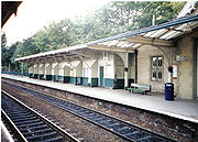
Today Beeston has good rail transport links with Beeston station
Beeston railway station
Beeston railway station is a railway station on the Midland Main Line which serves the town of Beeston in Nottinghamshire, England. It lies south west of Nottingham railway station...
, on the Midland Main Line
Midland Main Line
The Midland Main Line is a major railway route in the United Kingdom, part of the British railway system.The present-day line links London St...
, served by East Midlands Trains
East Midlands Trains
East Midlands Trains is a British passenger train operating company. Based in Derby, it provides train services in the East Midlands, chiefly in the counties of Lincolnshire, South Yorkshire, Nottinghamshire, Leicestershire, Derbyshire and Northamptonshire, and between the East Midlands and London...
and Arriva Cross Country. Direct trains to and from London St Pancras
St Pancras railway station
St Pancras railway station, also known as London St Pancras and since 2007 as St Pancras International, is a central London railway terminus celebrated for its Victorian architecture. The Grade I listed building stands on Euston Road in St Pancras, London Borough of Camden, between the...
call at Beeston, on an hourly frequency each way, with journey times to/from the capital being typically just under 2 hours. The distance (by rail) to St Pancras is 123 miles (197.9 km).
There are also regular, direct services to Nottingham, Derby
Derby Midland railway station
Derby railway station , also known as Derby Midland Station, is a main line railway station serving the city of Derby in England. Owned by Network Rail and managed by East Midlands Trains, the station is also used by CrossCountry services and one Northern Rail service...
, Lincoln
Lincoln, Lincolnshire
Lincoln is a cathedral city and county town of Lincolnshire, England.The non-metropolitan district of Lincoln has a population of 85,595; the 2001 census gave the entire area of Lincoln a population of 120,779....
, Bedford
Bedford
Bedford is the county town of Bedfordshire, in the East of England. It is a large town and the administrative centre for the wider Borough of Bedford. According to the former Bedfordshire County Council's estimates, the town had a population of 79,190 in mid 2005, with 19,720 in the adjacent town...
, Burton upon Trent
Burton upon Trent
Burton upon Trent, also known as Burton-on-Trent or simply Burton, is a town straddling the River Trent in the east of Staffordshire, England. Its associated adjective is "Burtonian"....
, Leicester
Leicester
Leicester is a city and unitary authority in the East Midlands of England, and the county town of Leicestershire. The city lies on the River Soar and at the edge of the National Forest...
, Loughborough
Loughborough railway station
Loughborough railway station serves the town of Loughborough in Leicestershire, England. Situated on the Midland Main Line, 20 km north of Leicester, the station lies to the north-east of the town centre....
, Tamworth
Tamworth railway station
Tamworth railway station is located where the Cross Country Route passes over the West Coast Main Line, in the United Kingdom, although there is no rail link between the two lines...
(for WCML), Newark
Newark-on-Trent
Newark-on-Trent is a market town in Nottinghamshire in the East Midlands region of England. It stands on the River Trent, the A1 , and the East Coast Main Line railway. The origins of the town are possibly Roman as it lies on an important Roman road, the Fosse Way...
(Castle), Luton
Luton
Luton is a large town and unitary authority of Bedfordshire, England, 30 miles north of London. Luton and its near neighbours, Dunstable and Houghton Regis, form the Luton/Dunstable Urban Area with a population of about 250,000....
, East Midlands Parkway
East Midlands Parkway railway station
East Midlands Parkway is a railway station located north of Ratcliffe-on-Soar on the Midland Main Line in the East Midlands of England. It provides park and ride facilities for rail passengers on the routes from Leicester to Derby and Nottingham...
(for the Airport), Birmingham
Birmingham
Birmingham is a city and metropolitan borough in the West Midlands of England. It is the most populous British city outside the capital London, with a population of 1,036,900 , and lies at the heart of the West Midlands conurbation, the second most populous urban area in the United Kingdom with a...
(New Street) and Matlock. Direct trains to Gloucester
Gloucester
Gloucester is a city, district and county town of Gloucestershire in the South West region of England. Gloucester lies close to the Welsh border, and on the River Severn, approximately north-east of Bristol, and south-southwest of Birmingham....
and Cardiff
Cardiff
Cardiff is the capital, largest city and most populous county of Wales and the 10th largest city in the United Kingdom. The city is Wales' chief commercial centre, the base for most national cultural and sporting institutions, the Welsh national media, and the seat of the National Assembly for...
exist (Monday-Saturday) in the morning and from those cities in the evening. There is also a direct train to Bournemouth
Bournemouth railway station
Bournemouth railway station, originally known as Bournemouth East and then Bournemouth Central , is the main railway station serving the town of Bournemouth in Dorset, England. It is located on the South Western Main Line from London Waterloo to Weymouth...
at 06:43 Monday-Saturday.
Bus
Frequent bus services operate to Nottingham, East Midlands Airport, DerbyDerby
Derby , is a city and unitary authority in the East Midlands region of England. It lies upon the banks of the River Derwent and is located in the south of the ceremonial county of Derbyshire. In the 2001 census, the population of the city was 233,700, whilst that of the Derby Urban Area was 229,407...
, Loughborough
Loughborough
Loughborough is a town within the Charnwood borough of Leicestershire, England. It is the seat of Charnwood Borough Council and is home to Loughborough University...
and other local towns, operated primarily by Trent Barton
Trent Barton
Trent Barton is one of the very small number of significant independent bus operators in the United Kingdom. It was formed as the result of merging Derbyshire's Trent Buses with Nottinghamshire's Barton Transport....
and Nottingham City Transport
Nottingham City Transport
Nottingham City Transport is the major bus operator of the English city of Nottingham, running a comprehensive network of services in the Greater Nottingham area, with some services continuing to Southwell, Loughborough, and East Midlands Airport. There are over 80 routes across the City, giving...
. Beeston has a bus station
Beeston bus station
Beeston bus station serves the town of Beeston, Nottinghamshire, England.The bus station is situated in the town centre just off Station Road and consists of six stands in total...
located just off Station Road in the town centre.
Nottingham City Transport
Nottingham City Transport
Nottingham City Transport is the major bus operator of the English city of Nottingham, running a comprehensive network of services in the Greater Nottingham area, with some services continuing to Southwell, Loughborough, and East Midlands Airport. There are over 80 routes across the City, giving...
- 13: Nottingham - Castle Boulevard - University Campus - Beeston - Brook Road.
- 14: Nottingham - Castle Boulevard - University Boulevard - Beeston - Chilwell.
- 36: Nottingham - QMC - Beeston - Chilwell.
- N36: Nottingham - QMC - University Campus - Beeston - Chilwell.
- L10: Nottingham - Wollaton - Beeston.
- L11: Arnold - Bulwell - Bilborough - Beeston.
Trent Barton
Trent Barton
Trent Barton is one of the very small number of significant independent bus operators in the United Kingdom. It was formed as the result of merging Derbyshire's Trent Buses with Nottinghamshire's Barton Transport....
- Indigo: Nottingham - QMC - University Boulevard - Beeston - Chilwell - Long Eaton / Derby / Sawley / Loughborough.
- 18: Nottingham - QMC - University Boulevard - Boots - Beeston - Stapleford.
- 20 (Sundays only): Nottingham - QMC - University Boulevard - Boots - Beeston - Ilkeston - Heanor.
Premiere Travel
Premiere Travel
Premiere Travel is a family-owned bus and coach operator largely serving the Nottinghamshire area. The company was formed in 2002 with a pair of Leyland Nationals and has developed into a significant size providing mainly local bus services....
- RED5: Nottingham - QMC - Beeston - Chilwell - Long Eaton.
- 17: Nottingham - QMC - Stapleford - Toton - Beeston.
- 63: Beeston - QMC - Clifton - East Leake - Keyworth.
YourBus
Yourbus
Dunn Motor Traction Ltd., trading as Yourbus, is a bus company based in Heanor, Derbyshire. It was formed by Scott Dunn in June 2009...
- Y36: Nottingham - QMC - Beeston - Chilwell.
- 228: Beeston - QMC - Bulwell - Hucknall.
Light rail
Proposals to build a light rail (tramTram
A tram is a passenger rail vehicle which runs on tracks along public urban streets and also sometimes on separate rights of way. It may also run between cities and/or towns , and/or partially grade separated even in the cities...
) line through the town as part of an extension to the Nottingham Express Transit
Nottingham Express Transit
Nottingham Express Transit is a light-rail tramway in the Nottingham area in England. The first line opened to the public on 9 March 2004, having cost £200 million to construct. The scheme took sixteen years from conception to implementation...
system were approved by the Government in 2009. The line would run from Nottingham city centre to Beeston and then Chilwell. From a stop at University Boulevard, the line would head along Fletcher Road and Lower Road to a stop at Middle Street, then continue along Middle Street to a "Beeston Town Centre" stop near the existing bus station. After the Town Centre stop the line would continue roughly westwards on Chilwell Road to stops at Chilwell Road and then Castle College. After the college the line would continue through Chilwell and onto the terminus stop, a park and ride
Park and ride
Park and ride facilities are car parks with connections to public transport that allow commuters and other people wishing to travel into city centres to leave their vehicles and transfer to a bus, rail system , or carpool for the rest of their trip...
site called "Toton Lane", situated between Toton and Stapleford.
A motivation is the traffic jams on local roads during rush hour periods. There has been some opposition to the scheme by local traders and those along the proposed route, who have stated that they fear that during the construction work, business would likely be adversely affected and that the scheme is being imposed without concern for locals. However, a survey in 2004 by Nottingham Express Transit showed strong local support for the scheme.
Cycle Routes
The National Cycle Network Route 6 (London - Keswick) passes through Beeston, the route passes through Long Lane Attenborough, then along the pavement of A6005 Queens Road, Lilac Grove, past Nottingham University and into the City Centre along the Canal.A circular route called 'The Big Track' is used by Cyclists and Pedestrians, it follows towpaths along most of the Nottingham Urban sections of River Trent and the entirety of Beeston Canal
Numerous other cycle routes through Beeston have also been signposted by the council.
Built environment
St. John the Baptist Church, Beeston
St. John the Baptist Church is an Anglican church in Beeston, Nottinghamshire, England.The church is Grade II listed by the Department for Culture, Media & Sport as it is a building of special architectural or historic interest.-History:...
. The church dates from the 11th century but was largely rebuilt in 1843 by Sir George Gilbert Scott
George Gilbert Scott
Sir George Gilbert Scott was an English architect of the Victorian Age, chiefly associated with the design, building and renovation of churches, cathedrals and workhouses...
. Both are included in the West End conservation area
Conservation Area (United Kingdom)
In the United Kingdom, the term Conservation Area nearly always applies to an area considered worthy of preservation or enhancement because of its special architectural or historic interest, "the character or appearance of which it is desirable to preserve or enhance," as required by the Planning ...
which includes a considerable number of buildings, many historical or of character, along the streets of Dovecote Lane, Grange Avenue, West End, and Church Street. Also included in the area is the historic Village Cross.
Information on Beeston Parish Church on the Southwell Diocesan History Project website
An act was passed for enclosing lands in the parish of Beeston, and in 1809 the Commissioners stated that the lands amounted to 822 acres (3.3 km²), to be made tithe free, and the ancient enclosed lands and homesteads liable to tithe was £687 2s 29d. They then proceeded to fix the width of the roads. The Nottingham and Derby turnpike road was fixed at 50 feet (15.2 m). Wollaton road, then called Cowgate, was 30 feet (9.1 m). The Inclosure not only altered the appearance of part of the parish from a moor growing poor grass, to cultivated fields with hedges, and thereby increasing the food supply, but it relieved farmers from the annoyance of having to hand over the tenth of their product in kind.
Some lands on or near Bramcote Moor, but in Beeston parish, were enclosed in 1847, by provisional order of the Inclosure Commissioners.
Before the introduction of gas generally in the parish there was a limited supply from the Mill to separate houses. The Church was first lit with gas in 1857. The Public Lighting Act was adopted at a Vestry Meeting on 13 November 1862. The opposition to lamps in the streets was strong, and the effigy of an active promoter of it was carried on an ass round the village and hung on a lamp-post, and but for police interference would have been burned. In 1861 gas was supplied from Nottingham by the Nottingham Gas Light and Coke Company, and for street lamps in 1872. Beeston was connected to the mains water supply in 1876.
A cottage on the north side of Anglo-Scotian Mills was reputed to have the tallest domestic chimney in England. Its length was necessary to reach over the roof of the Mill. Although the cottage has been demolished for several years, the chimney can still be seen attached to the wall of the Mill.
A rare survival is the G H Hurt & Son Shawl Factory, which is occasionally open to the public. Shawls are produced on knitting machines and hand finished in much the same way as they have been for centuries. The factory contains examples of knitting frames from the 17th century.
Lost industrial buildings include the rebuilt silk mill and the looming bulk of the Neville Works mill on the boundary with Chilwell (later occupied by the Myford lathe factory).
The Land Societies
See a Google Map of the EstatesSt. John's Grove Estate
Following the enclosure of the land surrounding Beeston in 1809 the area of St. John's Grove was allotted to the vicar of the parish church. In 1878 the land was acquired from the Ecclesiastical CommissionersEcclesiastical Commissioners
Ecclesiastical Commissioners were, in England and Wales, a body corporate, whose full title is Ecclesiastical and Church Estates Commissioners for England. The commissioners were authorized to determine the distribution of revenues of the Church of England, and they made extensive changes in how...
by the Beeston Land Society, a group of citizens, who divided the land out into 28 plots of between three-quarters and 1 acres (4,046.9 m²) and set out the wide straight streets. The majority of the houses are of Edwardian and late Victorian origin. The Land Society set conditions for the developers including no public houses, and strict building lines which ensured that properties were set back a consistent distance from the road. The St. John's Grove Estate is now a conservation area.
Imperial Park Estate
Shortly after 1878, the Imperial Park Land Society and it sister organisation Beeston Building Society were founded. Together, they aimed to assist the development and financing of superior housing, centred on what is now Imperial Road, north of Newton Street, adjacent to the St John's Grove development and bounded on the north by North Street. The early model was saving by a group of subscribers and the allocation of funds as they accumulated by the drawing of lots, in turn for each of them to build a house.Bellevue Park Estate
This initial success was repeated when, in 1881, a syndicate acquired land from George Fellows, of the banking family that had its home at Belle Vue, now Beeston Fields Golf Club. The Belle Vue Land Society was formed to develop this land using similar methods to Imperial Park. The development lay to the north and formed a continuation to Imperial Park. Denison Street formed its northern extreme and Montague Street defined its eastern limit.Cottage Grove
Cottage Grove, which historically was just outside Beeston parish and part of ChilwellChilwell
Chilwell is a residential suburb of Greater Nottingham, in the Borough of Broxtowe of Nottinghamshire, west of Nottingham city. Until 1974 it was part of Beeston and Stapleford Urban District, having been in Stapleford Rural District until 1935.-History:...
, was originally promoted by the Labourer's Friend Society
Labourer's Friend Society
The Labourer's Friend Society was a society founded by Benjamin Wills in the United Kingdom in 1830 for the improvement of working class conditions...
in the 1840s as plots for cottages with allotments for the labouring poor. This scheme failed and the area now consists mostly of Victorian and Edwardian houses laid out along the parallel Park Road and Grove Avenue and the two short cross streets Cedar Road and North Drive. The area retains a leafy character and the roads remain unkerbed, and has been a conservation area since 2008.
The Estates today
Some areas originally developed by the Land Societies have been spoiled where original plots have been subdivided and more modern properties built in styles not in keeping with some of the original buildings. Many of the properties in the Imperial Park and Bellvue Estates have lost their original elegance with the lowering of chimney stacks, inappropriate replacement of windows and doors with modern PVCu, the loss of hedged fronts to brick walls or fencing, and paving over front gardens for parking.Other development
Light pollution
Light pollution, also known as photopollution or luminous pollution, is excessive or obtrusive artificial light.The International Dark-Sky Association defines light pollution as:...
.
Rylands was originally a small settlement around Beeston Lock, comprising some tens of houses and two pubs, although the name now refers to all of the area south of the railway line. The Jolly Angler was originally on the river side of the canal, but has since moved. Beeston began to spread south of the railway line in the late 19th century when a few Victorian villas were built near the level crossing by the station. Over the first few decades of the 20th century, several estates were built to house the workers at Ericssons and Boots, both of which had large factory sites also south of the railway line, and these estates joined Beeston and Rylands. Further post-WWII development filled in the gaps, initially with an estate of council houses and flats, and latterly with private houses and bungalows. The last significant development was in 1970 of Meadow Farm, now the four roads of timber-framed semi-detached houses between Beech Avenue and the canal. Since then Beeston Rylands has had only a small amount of infill development.
Almshouses
The United Charities of Abel CollinAbel Collin
Abel Collin was a benefactor in Nottingham. He established Abel Collin's Charity.-Family:He was the son of Laurence Collin.His sister, Fortune Collin, married Thomas Smith, founder of Smith's Bank in Nottingham.-History of the Charity:...
moved from the centre of Nottingham to their current location on Derby Road in Beeston during the 1950s.
Commerce
There are also large numbers of takeaways and several restaurants, offering a wide selection of food including Chinese, Thai, and Indian cuisine. Many cafés are to be found around the main shopping centre, "The Square"—the centre of Beeston—is a 1960s shopping development, most of which is pedestrianised. A £1.4-million environmental improvement scheme covered pavements and lighting for the non-pedestrianised eastern end of the High Street. Further east Broadgate saw improvements, with a new space at the top entrance to Broadgate Recreation Ground. The works were completed in late 2006.
The shopping centre is cut in two by Wollaton Road which has a very high volume of traffic. The lighting installed at the time of a 1980s refurbishment of the square contributes to local light pollution
Light pollution
Light pollution, also known as photopollution or luminous pollution, is excessive or obtrusive artificial light.The International Dark-Sky Association defines light pollution as:...
. A large area south east of the shopping centre has made room for a Tesco
Tesco
Tesco plc is a global grocery and general merchandise retailer headquartered in Cheshunt, United Kingdom. It is the third-largest retailer in the world measured by revenues and the second-largest measured by profits...
superstore, which opened 1 November 2010, rivalling the Sainsbury's store located in the town centre and the recently built Lidl
Lidl
Lidl is a discount supermarket chain based in Germany that operates over 7,200 stores across Europe. The company's full name is Lidl Stiftung & Co. KG...
store on Wollaton Road to the north of the town centre. Beeston Fire Station on an adjacent plot has been closed and relocated to a new site on Hassocks Lane.
Pubs
Public house
A public house, informally known as a pub, is a drinking establishment fundamental to the culture of Britain, Ireland, Australia and New Zealand. There are approximately 53,500 public houses in the United Kingdom. This number has been declining every year, so that nearly half of the smaller...
s and has one of the highest concentrations of pubs-per-person in the United Kingdom with 23 pubs (as of 2011) within as per the Beeston Crawl.
The Victoria Hotel, a Victorian
Victorian era
The Victorian era of British history was the period of Queen Victoria's reign from 20 June 1837 until her death on 22 January 1901. It was a long period of peace, prosperity, refined sensibilities and national self-confidence...
railway hotel and pub adjacent to the railway station, has received several local awards, including "Nottinghamshire Dining Pub of the Year" – Good Pub Guide 2002, and runner-up for The Times
The Times
The Times is a British daily national newspaper, first published in London in 1785 under the title The Daily Universal Register . The Times and its sister paper The Sunday Times are published by Times Newspapers Limited, a subsidiary since 1981 of News International...
– "Pub of the Year", 2000.
The Victoria Hotel and the Malt Shovel, on Union Street, both appear in the 2010 and 2011 editions of the CAMRA
Campaign for Real Ale
The Campaign for Real Ale is an independent voluntary consumer organisation based in St Albans, England, whose main aims are promoting real ale, real cider and the traditional British pub...
Good Beer Guide
Good Beer Guide
The Good Beer Guide is a book published annually by the Campaign for Real Ale listing what they consider to be the best cask ale outlets in the United Kingdom.-Details:...
. The Crown, a listed building on Church Street, in the West End conservation area, was awarded the Nottingham, then the Nottinghamshire and then the East Midlands
East Midlands
The East Midlands is one of the regions of England, consisting of most of the eastern half of the traditional region of the Midlands. It encompasses the combined area of Nottinghamshire, Derbyshire, Leicestershire, Rutland, Northamptonshire and most of Lincolnshire...
CAMRA "Pub of the Year" 2010 awards and now appears in the 2011 edition of the Guide. There is a Wetherspoon's chain pub called The Last Post, situated in the building of the old Royal Mail sorting office and still adjacent to the town's main post office.
In the southeast of the town, on Factory Lane, a small brewery
Brewery
A brewery is a dedicated building for the making of beer, though beer can be made at home, and has been for much of beer's history. A company which makes beer is called either a brewery or a brewing company....
— called Reality — began producing real ale in 2010, with a 2.5 barrel plant.
Royal Mail
Beeston has three post officePost office
A post office is a facility forming part of a postal system for the posting, receipt, sorting, handling, transmission or delivery of mail.Post offices offer mail-related services such as post office boxes, postage and packaging supplies...
s — the main one is on Chilwell Road (on a site that was once also the town's delivery office), another exists in the town centre on High Road (towards Broadgate), and a third on Central Avenue in the northern part of the town. A fourth post office did exist in the Rylands part of town, but was closed in January 2008 as part of a wider review.
The Royal Mail
Royal Mail
Royal Mail is the government-owned postal service in the United Kingdom. Royal Mail Holdings plc owns Royal Mail Group Limited, which in turn operates the brands Royal Mail and Parcelforce Worldwide...
's main sorting office
Sorting office
Sorting office or Processing and Distribution Center is any location where postal operators bring mail after collection for sorting into batches for delivery to the addressee, which may be a direct delivery or sent onwards to another regional or local sorting office, or to another postal...
for the Nottingham area (the NG postcode area) is sited on the eastern edge of the town at Padge Road, with the City of Nottingham boundary running around the building. It was built in 1995 and includes the new delivery office for handling the local distribution of Beeston's mail.
Sport
Beeston is home to England Hockey Premier League team Beeston Hockey ClubBeeston Hockey Club
Beeston Hockey Club was founded in 1907. Beeston play their home games at the superb facilities at Highfields Sports Club in Nottingham, England. Beeston play in the English Hockey League premier division recently finishing 2nd in the 2009/10 season, losing to East Grinstead Hockey Club in the...
who play at Highfields Sports Club on University Boulevard.
Until 2006, Beeston was home to Nottingham Rugby Club
Nottingham R.F.C.
Nottingham Rugby Football Club are a rugby union club based in Nottingham, England. The club's first team currently play in the Championship, the second tier of English Rugby....
, which sold the land next to the railway line (now the Birkin Fields housing development) and moved to share the Meadow Lane
Meadow Lane
Not to be confused with The Meadow, home of Southern Football League Premier Division football team Chesham UnitedThe Meadow Lane Stadium is a football stadium in Nottingham, England...
pitch at the Notts County ground. Nottingham Casuals Rugby Club still play on the rugby pitches at Weirfields near the canal.
Two golf course
Golf course
A golf course comprises a series of holes, each consisting of a teeing ground, fairway, rough and other hazards, and a green with a flagstick and cup, all designed for the game of golf. A standard round of golf consists of playing 18 holes, thus most golf courses have this number of holes...
s exist adjacent to the town: Beeston Fields and Chilwell Manor. A short distance to the north is Bramcote Hill
Bramcote Hills
Bramcote Hills forms the northern area of the village and Nottingham suburb of Bramcote, Nottinghamshire, built in the 1950s. It is separated from the main part of the village by the A52 Derby Road ....
Golf Club and to the northeast the golf course at Wollaton Park.
Beeston is also home to several well established football clubs, including Beeston Town FC who play their home games at Highfields and compete in Division One of the Long Eaton Sunday League.
Hydro electric plant
During 1999, Hyder Industrial Ltd. built the UK’s largest "run-of river" hydro-electricHydroelectricity
Hydroelectricity is the term referring to electricity generated by hydropower; the production of electrical power through the use of the gravitational force of falling or flowing water. It is the most widely used form of renewable energy...
plant at Beeston Rylands Weir. The plant was commissioned on 4 January 2000 and later sold on to United Utilities
United Utilities
United Utilities Group PLC is the UK's largest listed water business. The Group owns and manages the regulated water and waste water network in the north west England, through it subsidiary United Utilities Water PLC , which is responsible for the vast majority of the group's assets and...
in 2001. The plant has a design life of twenty years. At the maximum consented flow rate, 60 m3/s of water passes through the pair of turbines. Upstream of the weir and during the salmon migratory period, the plant utilises a bio-acoustic fish-fence—a bubble curtain
Bubble curtain
A bubble curtain is a system that produces bubbles in a deliberate arrangement in water. The technique is based on bubbles of air being let out under the water surface, commonly on the bottom...
in which the bubbles contain a sound that the fish do not like. This fish fence steers migrating fish away from the fast-flowing turbine intakes and into the fish ladder
Fish ladder
A fish ladder, also known as a fishway, fish pass or fish steps, is a structure on or around artificial barriers to facilitate diadromous fishes' natural migration. Most fishways enable fish to pass around the barriers by swimming and leaping up a series of relatively low steps into the waters on...
, by which the fish can safely negotiate the weir. The power generated supplies enough electricity (1.5 MW–1.66 MW) for two thousand homes, a total of 5.26 GWh annually.
Notable people from Beeston
- William "Bendigo" ThompsonWilliam Thompson (boxer)William Abednego Thompson was an English bare-knuckle boxer.-Early life:Born in Sneinton, Nottingham in 1811, Thompson was one of a set of triplets named Abednego, Shadrach and Meshak, after the young men in the Book of Daniel who emerged from the fiery furnace of Babylon...
, a 19th century bare-knuckle boxer. - Sir Paul Smith, the fashion designer who attended Beeston Fields Secondary Modern School for Boys whilst growing up.
- Sir Neil CossonsNeil CossonsSir Neil Cossons OBE FSA FMA is Pro-Provost and Chairman of the Council of the Royal College of Art, of which he has been a Governor since 1989. From 1986 to 2000 he was the Director of the Science Museum, London, UK, the National Museum of Science & Industry...
(Chairman of English HeritageEnglish HeritageEnglish Heritage . is an executive non-departmental public body of the British Government sponsored by the Department for Culture, Media and Sport...
) grew up in Beeston, attending Church Street School, where his father was the headmaster. One of his first jobs was working as a railway porter at Beeston railway stationBeeston railway stationBeeston railway station is a railway station on the Midland Main Line which serves the town of Beeston in Nottinghamshire, England. It lies south west of Nottingham railway station...
. - Edwin StarrEdwin StarrEdwin Starr was an American soul music singer. Starr is most famous for his Norman Whitfield produced singles of the 1970s, most notably the number one hit "War".-Biography:...
, the Soul singer lived in Beeston and died there in 2003. - Richard BeckinsaleRichard BeckinsaleRichard Arthur Beckinsale was an English actor, best known for his roles as Lennie Godber in the popular BBC sitcom Porridge and Alan Moore in the British sitcom Rising Damp....
, the actor was brought up in the town. - Dr Robert FelkinRobert FelkinRobert William Felkin was a medical missionary and explorer, a ceremonial magician and member of the Hermetic Order of the Golden Dawn, a prolific author on Uganda and Central Africa, and early anthropologist, with an interest in ethno-medicine and tropical diseases.He was founder in 1903 of the...
, medical missionary and explorer, ceremonial magician and member of the Hermetic Order of the Golden Dawn. - Little BarrieLittle BarrieLittle Barrie is a power trio that originated in Nottingham, Nottinghamshire, England, since relocated to London. Their sound could be described as stripped down R&B/Soul/Funk/Blues/Garage rock jamband. The band consists of Barrie Cadogan , Lewis Wharton and Virgil Howe . Before Howe, Billy...
, a music group that have since relocated to London. - Barry FosterBarry Foster (actor)Barry Foster was a British actor who appeared in numerous film roles and is known for his leading role as a Dutch detective in the ITV drama series, Van der Valk, which spanned five series over 20 years from 1972....
, the actor famous for playing Dutch detective Van Der Valk - Anne BriggsAnne BriggsAnne Briggs is an English folk singer. Although she traveled widely in the 1960s and early 1970s, appearing at folk clubs and venues in England and Ireland, she never aspired to commercial success or to achieve widespread public acknowledgment of her music...
, folk singer