
Broxtowe
Encyclopedia
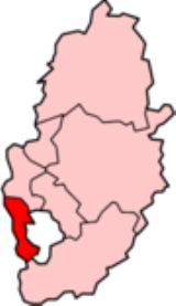
Broxtowe is a local government district
with borough
status in Nottinghamshire
, England
, west of the City of Nottingham
. It is part of the Greater Nottingham
metropolitan area. Broxtowe's neighbour to the west is the borough of Erewash
, which is in Derbyshire
.
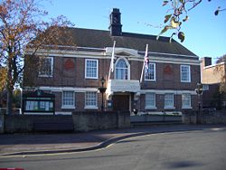
— where the council is based — Attenborough
, Awsworth
, Bramcote
, Brinsley
, Chilwell
, Cossall
, Eastwood
, Giltbrook
, Greasley
, Kimberley
, Moorgreen, Newthorpe
, Nuthall
, Stapleford
, Strelley, Swingate
, Toton
, Trowell
, and Watnall
. Additionally a small part of Wollaton
falls within Broxtowe.
The Broxtowe Estate is not within the borough, but is instead within the boundaries of the City of Nottingham.
of the borough covers the town of Beeston and the neighbouring places of Chilwell, Toton, Attenborough and Bramcote — this is the area of the former Beeston and Stapleford
Urban District, minus Stapleford which was parished in 1987.
 The district formed on April 1, 1974 by a merger of the Beeston and Stapleford urban district
, the Eastwood
urban district and part of Basford Rural District
. The borough's name was derived from the old Broxtowe
wapentake of Nottinghamshire, which covered a larger area.
The district was granted borough status
in 1977.
, with the Conservatives
gaining control. The party held power until 1995 when it lost control to the Labour
party. Since 2003 no party has been in overall control. Since the 2009 elections the Liberal Democrats
lead the council with Labour support, but the Conservatives have the largest representation on the council. The next whole-council elections
will be in May 2011.
. Each ward returns one to three councillors to the Borough Council, depending on the ward's electorate/population. Below is a summary list of the 21 wards and the number of councillors they each elect in brackets.
† These wards form the unparished area
of the borough.
has also been a Parliamentary
constituency. The constituency boundaries do not exactly match the borough boundaries, with some wards of Broxtowe borough (Brinsley, Eastwood North and Greasley (Beauvale), and Eastwood South) being in the Ashfield
constituency. The elections in the constituency have returned the following MPs
:
A Broxtowe constituency also existed form 1918 to 1970. The area of the former constituency was very different, including Hucknall
and Kirkby in Ashfield, but excluding Beeston
.
in Eastwood
.
A small local attraction is the Hemlock Stone
in Stapleford.
s, namely Alexandrina Plantation (Bramcote), Bramcote Park Woodland (Bramcote), Brinsley Headstocks (Brinsley), Hall Om Wong (Kimberley), King George's Park (Bramcote), Nottingham Canal
, Sandy Lane Public Open Space (Bramcote), Smithurst Meadows (Giltbrook), Stapleford Hill Woodland (Stapleford) and Toton Fields (Toton).
Non-metropolitan district
Non-metropolitan districts, or colloquially shire districts, are a type of local government district in England. As created, they are sub-divisions of non-metropolitan counties in a so-called "two-tier" arrangement...
with borough
Borough status in the United Kingdom
Borough status in the United Kingdom is granted by royal charter to local government districts in England, Wales and Northern Ireland. The status is purely honorary, and does not give any additional powers to the council or inhabitants of the district...
status in Nottinghamshire
Nottinghamshire
Nottinghamshire is a county in the East Midlands of England, bordering South Yorkshire to the north-west, Lincolnshire to the east, Leicestershire to the south, and Derbyshire to the west...
, England
England
England is a country that is part of the United Kingdom. It shares land borders with Scotland to the north and Wales to the west; the Irish Sea is to the north west, the Celtic Sea to the south west, with the North Sea to the east and the English Channel to the south separating it from continental...
, west of the City of Nottingham
Nottingham
Nottingham is a city and unitary authority in the East Midlands of England. It is located in the ceremonial county of Nottinghamshire and represents one of eight members of the English Core Cities Group...
. It is part of the Greater Nottingham
Greater Nottingham
The Nottingham Urban Area is an area of land defined by the Office for National Statistics, consisting of the city of Nottingham and the adjoining urban areas of Nottinghamshire and Derbyshire, in the East Midlands of England...
metropolitan area. Broxtowe's neighbour to the west is the borough of Erewash
Erewash
Erewash is a local government district and borough in eastern Derbyshire, England, to the east of Derby and the west of Nottingham. It contains the towns of Ilkeston, Long Eaton and Sandiacre and fourteen civil parishes....
, which is in Derbyshire
Derbyshire
Derbyshire is a county in the East Midlands of England. A substantial portion of the Peak District National Park lies within Derbyshire. The northern part of Derbyshire overlaps with the Pennines, a famous chain of hills and mountains. The county contains within its boundary of approx...
.
Settlements
Settlements include BeestonBeeston, Nottinghamshire
Beeston is a town in Nottinghamshire, England. It is southwest of Nottingham city centre. Although typically regarded as a suburb of the City of Nottingham, and officially designated as part of the Nottingham Urban Area, for local government purposes it is in the borough of Broxtowe, lying outside...
— where the council is based — Attenborough
Attenborough, Nottinghamshire
Attenborough is a village and a suburb in the Broxtowe borough of Nottinghamshire. It forms part of Greater Nottingham, and is to the southwest of Nottingham, between Long Eaton and Beeston...
, Awsworth
Awsworth
Awsworth is a village and civil parish in the Broxtowe district of Nottinghamshire, England. It had a population of 2,266 in 2001. The village is near the edge of the Greater Nottingham area, between Kimberley and Ilkeston, Derbyshire....
, Bramcote
Bramcote
Bramcote is a settlement in the Broxtowe district of Nottinghamshire, about five miles west of Nottingham. It was a separate village but is now a suburb of Greater Nottingham. Originally one of the main roads between the cities of Nottingham and Derby passed through the village centre...
, Brinsley
Brinsley
Brinsley is a village in Nottinghamshire, England. The church of St James was built in 1837-38 from Mansfield stone, the chancel being added in 1877....
, Chilwell
Chilwell
Chilwell is a residential suburb of Greater Nottingham, in the Borough of Broxtowe of Nottinghamshire, west of Nottingham city. Until 1974 it was part of Beeston and Stapleford Urban District, having been in Stapleford Rural District until 1935.-History:...
, Cossall
Cossall
Cossall is a hamlet in Nottinghamshire, England. It is located 1 mile east of Ilkeston. According to the 2001 census it had a population of 612. To the north of the hamlet is a large hill or slag heap, produced from tons of waste extracted from the local coal mines....
, Eastwood
Eastwood, Nottinghamshire
Eastwood is a former coal mining town in the Broxtowe district of Nottinghamshire, England. With a population of over 18,000, it is northwest of Nottingham, and northeast of Derby, on the border between Nottinghamshire and Derbyshire. Mentioned in Domesday Book, it expanded rapidly during the...
, Giltbrook
Giltbrook
Giltbrook is a village situated approximately 10 kilometres West-northwest of Nottingham and within close reach of junction 26 of the M1 motorway. It is part of Greasley ward, which had a population of 6,076 in 2001....
, Greasley
Greasley
Greasley is a parish north west of Nottingham in Nottinghamshire, England. Although it is thought there was once a village called Greasley, there is no settlement of that name today. The built up areas in the parish are Giltbrook, Moorgreen , Newthorpe, Watnall and parts of Eastwood, Kimberley and...
, Kimberley
Kimberley, Nottinghamshire
Kimberley is a town in Nottinghamshire, England, lying 6 miles northwest of Nottingham along the A610. The town grew as a centre for coal mining, brewing and hosiery manufacturing...
, Moorgreen, Newthorpe
Newthorpe, Nottinghamshire
Newthorpe is a village in the English county of Nottinghamshire.It forms part of the borough of Broxtowe being east of, and contiguous with, the town of Eastwood....
, Nuthall
Nuthall
Nuthall is a village located in Nottinghamshire, England, neighbouring Kimberley, Watnall, Cinderhill and Basford.It is part of the Borough of Broxtowe....
, Stapleford
Stapleford, Nottinghamshire
-External links:***...
, Strelley, Swingate
Swingate, Nottinghamshire
Swingate is a small English village positioned in the centre of Kimberley and Babbington. It is a parish within Broxtowe Borough Council....
, Toton
Toton
Toton is a small suburb of Nottingham. It forms part of the Greater Nottingham urban area, and is in the Borough of Broxtowe. The inhabited area is contained within the electoral ward of Toton and Chilwell Meadows...
, Trowell
Trowell
Trowell is a village and civil parish in Nottinghamshire, England. It lies a few miles west of Nottingham, in the borough of Broxtowe on the border with Derbyshire. According to the 2001 census it had a population of 2,568....
, and Watnall
Watnall
Watnall is an area of settlement in Nottinghamshire, England. It is part of Greasley civil parish, and is located one mile north of Kimberley. The village is barely separated from Nuthall. Generally both areas are considered to be more affluent and middle-class than the neighbouring town of...
. Additionally a small part of Wollaton
Wollaton
Wollaton is an area in the western part of Nottingham, England. It is home to Wollaton Hall with its museum, deer park, lake, walks and golf course...
falls within Broxtowe.
The Broxtowe Estate is not within the borough, but is instead within the boundaries of the City of Nottingham.
Civil parishes
Broxtowe has ten civil parishes of which three (Eastwood, Kimberley and Stapleford) have town councils. The unparished areaUnparished area
In England, an unparished area is an area that is not covered by a civil parish. Most urbanised districts of England are either entirely or partly unparished. Many towns and some cities in otherwise rural districts are also unparished areas and therefore no longer have a town council or city...
of the borough covers the town of Beeston and the neighbouring places of Chilwell, Toton, Attenborough and Bramcote — this is the area of the former Beeston and Stapleford
Beeston and Stapleford
Beeston and Stapleford was an urban district in Nottinghamshire, England, from 1935 to 1974.It was created by a County Review Order. Beeston had previously been part of Beeston Urban District itself, to which was added the entirety of the Stapleford Rural District, consisting of the parishes of...
Urban District, minus Stapleford which was parished in 1987.
Formation
Urban district
In the England, Wales and Ireland, an urban district was a type of local government district that covered an urbanised area. Urban districts had an elected Urban District Council , which shared local government responsibilities with a county council....
, the Eastwood
Eastwood, Nottinghamshire
Eastwood is a former coal mining town in the Broxtowe district of Nottinghamshire, England. With a population of over 18,000, it is northwest of Nottingham, and northeast of Derby, on the border between Nottinghamshire and Derbyshire. Mentioned in Domesday Book, it expanded rapidly during the...
urban district and part of Basford Rural District
Basford Rural District
Basford was an rural district close to Nottingham, England, from 1894 to 1974. The district consisted of two detached parts, to the north and south of Nottingham...
. The borough's name was derived from the old Broxtowe
Broxtowe (wapentake)
Broxtowe was a wapentake of the ancient county of Nottinghamshire, England.It was in the west of the county covering the parishes of Annesley, Arnold, Attenborough, Basford, Beeston, Bestwood Park, Bilborough, Bramcote, Brewhouse Yard, Bulwell, Chilwell, Cossall, Eastwood, Felley, Fulwood,...
wapentake of Nottinghamshire, which covered a larger area.
The district was granted borough status
Borough status in the United Kingdom
Borough status in the United Kingdom is granted by royal charter to local government districts in England, Wales and Northern Ireland. The status is purely honorary, and does not give any additional powers to the council or inhabitants of the district...
in 1977.
Politics
The first elections to the council took place in 1973United Kingdom local elections, 1973
The first elections to the new local authorities established by the Local Government Act 1972 in England and Wales and the new Northern Ireland district councils created by the Local Government Act 1972 took place in 1973...
, with the Conservatives
Conservative Party (UK)
The Conservative Party, formally the Conservative and Unionist Party, is a centre-right political party in the United Kingdom that adheres to the philosophies of conservatism and British unionism. It is the largest political party in the UK, and is currently the largest single party in the House...
gaining control. The party held power until 1995 when it lost control to the Labour
Labour Party (UK)
The Labour Party is a centre-left democratic socialist party in the United Kingdom. It surpassed the Liberal Party in general elections during the early 1920s, forming minority governments under Ramsay MacDonald in 1924 and 1929-1931. The party was in a wartime coalition from 1940 to 1945, after...
party. Since 2003 no party has been in overall control. Since the 2009 elections the Liberal Democrats
Liberal Democrats
The Liberal Democrats are a social liberal political party in the United Kingdom which supports constitutional and electoral reform, progressive taxation, wealth taxation, human rights laws, cultural liberalism, banking reform and civil liberties .The party was formed in 1988 by a merger of the...
lead the council with Labour support, but the Conservatives have the largest representation on the council. The next whole-council elections
Broxtowe Council election, 2011
Elections to Broxtowe Borough Council were held on 5 May 2011 to elect all 44 members to the Council.The Conservative party held overall control of the council from its foundation in 1973 until 1995 when the Labour party took control. The 2003 election saw Labour lose overall control of the council...
will be in May 2011.
Wards
Since boundary changes in 2003, 44 councillors are elected from 21 wardsWards of the United Kingdom
A ward in the United Kingdom is an electoral district at sub-national level represented by one or more councillors. It is the primary unit of British administrative and electoral geography .-England:...
. Each ward returns one to three councillors to the Borough Council, depending on the ward's electorate/population. Below is a summary list of the 21 wards and the number of councillors they each elect in brackets.
- AttenboroughAttenborough, NottinghamshireAttenborough is a village and a suburb in the Broxtowe borough of Nottinghamshire. It forms part of Greater Nottingham, and is to the southwest of Nottingham, between Long Eaton and Beeston...
(1) † - AwsworthAwsworthAwsworth is a village and civil parish in the Broxtowe district of Nottinghamshire, England. It had a population of 2,266 in 2001. The village is near the edge of the Greater Nottingham area, between Kimberley and Ilkeston, Derbyshire....
(1) - BeestonBeeston, NottinghamshireBeeston is a town in Nottinghamshire, England. It is southwest of Nottingham city centre. Although typically regarded as a suburb of the City of Nottingham, and officially designated as part of the Nottingham Urban Area, for local government purposes it is in the borough of Broxtowe, lying outside...
Central (2) † - Beeston North (2) † - includes a very small part of WollatonWollatonWollaton is an area in the western part of Nottingham, England. It is home to Wollaton Hall with its museum, deer park, lake, walks and golf course...
- Beeston Rylands (2) †
- Beeston West (2) †
- BramcoteBramcoteBramcote is a settlement in the Broxtowe district of Nottinghamshire, about five miles west of Nottingham. It was a separate village but is now a suburb of Greater Nottingham. Originally one of the main roads between the cities of Nottingham and Derby passed through the village centre...
(3) † - includes a small part of WollatonWollatonWollaton is an area in the western part of Nottingham, England. It is home to Wollaton Hall with its museum, deer park, lake, walks and golf course... - BrinsleyBrinsleyBrinsley is a village in Nottinghamshire, England. The church of St James was built in 1837-38 from Mansfield stone, the chancel being added in 1877....
(1) - ChilwellChilwellChilwell is a residential suburb of Greater Nottingham, in the Borough of Broxtowe of Nottinghamshire, west of Nottingham city. Until 1974 it was part of Beeston and Stapleford Urban District, having been in Stapleford Rural District until 1935.-History:...
East (2) † - Chilwell West (3) †
- CossallCossallCossall is a hamlet in Nottinghamshire, England. It is located 1 mile east of Ilkeston. According to the 2001 census it had a population of 612. To the north of the hamlet is a large hill or slag heap, produced from tons of waste extracted from the local coal mines....
& KimberleyKimberley, NottinghamshireKimberley is a town in Nottinghamshire, England, lying 6 miles northwest of Nottingham along the A610. The town grew as a centre for coal mining, brewing and hosiery manufacturing...
(3) - EastwoodEastwood, NottinghamshireEastwood is a former coal mining town in the Broxtowe district of Nottinghamshire, England. With a population of over 18,000, it is northwest of Nottingham, and northeast of Derby, on the border between Nottinghamshire and Derbyshire. Mentioned in Domesday Book, it expanded rapidly during the...
North & GreasleyGreasleyGreasley is a parish north west of Nottingham in Nottinghamshire, England. Although it is thought there was once a village called Greasley, there is no settlement of that name today. The built up areas in the parish are Giltbrook, Moorgreen , Newthorpe, Watnall and parts of Eastwood, Kimberley and...
(BeauvaleBeauvaleBeauvale, or Beauvale Newthorpe, is a village in Nottinghamshire, England. It is located 1 mile to the east of Eastwood. It is in Greasley parish. Beauvale Priory is the remains of a Carthusian house, or Charterhouse, founded in 1343 by Nicholas de Cantilupe. The extant remains include part of the...
) (2) - Eastwood South (3)
- Greasley (GiltbrookGiltbrookGiltbrook is a village situated approximately 10 kilometres West-northwest of Nottingham and within close reach of junction 26 of the M1 motorway. It is part of Greasley ward, which had a population of 6,076 in 2001....
& NewthorpeNewthorpe, NottinghamshireNewthorpe is a village in the English county of Nottinghamshire.It forms part of the borough of Broxtowe being east of, and contiguous with, the town of Eastwood....
) (3) - NuthallNuthallNuthall is a village located in Nottinghamshire, England, neighbouring Kimberley, Watnall, Cinderhill and Basford.It is part of the Borough of Broxtowe....
East & Strelley (2) - Nuthall West & Greasley (WatnallWatnallWatnall is an area of settlement in Nottinghamshire, England. It is part of Greasley civil parish, and is located one mile north of Kimberley. The village is barely separated from Nuthall. Generally both areas are considered to be more affluent and middle-class than the neighbouring town of...
) (2) - StaplefordStapleford, Nottinghamshire-External links:***...
North (2) - Stapleford South East (2)
- Stapleford South West (2)
- TotonTotonToton is a small suburb of Nottingham. It forms part of the Greater Nottingham urban area, and is in the Borough of Broxtowe. The inhabited area is contained within the electoral ward of Toton and Chilwell Meadows...
& Chilwell Meadows (3) † - TrowellTrowellTrowell is a village and civil parish in Nottinghamshire, England. It lies a few miles west of Nottingham, in the borough of Broxtowe on the border with Derbyshire. According to the 2001 census it had a population of 2,568....
(1)
† These wards form the unparished area
Unparished area
In England, an unparished area is an area that is not covered by a civil parish. Most urbanised districts of England are either entirely or partly unparished. Many towns and some cities in otherwise rural districts are also unparished areas and therefore no longer have a town council or city...
of the borough.
Parliamentary Constituency
Since 1983 BroxtoweBroxtowe (UK Parliament constituency)
Broxtowe is a county constituency represented in the House of Commons of the Parliament of the United Kingdom. It elects one Member of Parliament by the first past the post system of election...
has also been a Parliamentary
Parliament of the United Kingdom
The Parliament of the United Kingdom of Great Britain and Northern Ireland is the supreme legislative body in the United Kingdom, British Crown dependencies and British overseas territories, located in London...
constituency. The constituency boundaries do not exactly match the borough boundaries, with some wards of Broxtowe borough (Brinsley, Eastwood North and Greasley (Beauvale), and Eastwood South) being in the Ashfield
Ashfield (UK Parliament constituency)
Ashfield is a county constituency represented in the House of Commons of the Parliament of the United Kingdom. It elects one Member of Parliament by the first-past-the-post voting system....
constituency. The elections in the constituency have returned the following MPs
Member of Parliament
A Member of Parliament is a representative of the voters to a :parliament. In many countries with bicameral parliaments, the term applies specifically to members of the lower house, as upper houses often have a different title, such as senate, and thus also have different titles for its members,...
:
- 1992 Sir Jim LesterJim LesterSir James Theodore Lester, , known as Jim Lester, is a former British Conservative Party politician.Born in Nottingham, Lester was Member of Parliament for Beeston between February 1974 and 1983, then for Broxtowe until the 1997 election, when he lost his seat to Labour...
(Conservative) - 1997 Nick PalmerNick PalmerNicholas Douglas Palmer is a British Labour Party politician. He was the Member of Parliament for Broxtowe in Nottinghamshire from 1997 until he lost the seat at the 2010 general election to Conservative Anna Soubry, by 390 votes.Described by Andrew Roth as "quietly effective", he was...
(Labour) - 2001 Nick PalmerNick PalmerNicholas Douglas Palmer is a British Labour Party politician. He was the Member of Parliament for Broxtowe in Nottinghamshire from 1997 until he lost the seat at the 2010 general election to Conservative Anna Soubry, by 390 votes.Described by Andrew Roth as "quietly effective", he was...
(Labour) - 2005 Nick PalmerNick PalmerNicholas Douglas Palmer is a British Labour Party politician. He was the Member of Parliament for Broxtowe in Nottinghamshire from 1997 until he lost the seat at the 2010 general election to Conservative Anna Soubry, by 390 votes.Described by Andrew Roth as "quietly effective", he was...
(Labour) - 2010 Anna SoubryAnna SoubryAnna Mary Soubry is a British Conservative Party politician who has been the Member of Parliament for Broxtowe since the 2010 general election. She is a single mother of two children....
(Conservative)
A Broxtowe constituency also existed form 1918 to 1970. The area of the former constituency was very different, including Hucknall
Hucknall
Hucknall, formerly known as Hucknall Torkard, is a town in Greater Nottingham, Nottinghamshire, England, in the district of Ashfield. The town was historically a centre for framework knitting and then for mining but is now a focus for other industries as well providing housing for workers in...
and Kirkby in Ashfield, but excluding Beeston
Beeston, Nottinghamshire
Beeston is a town in Nottinghamshire, England. It is southwest of Nottingham city centre. Although typically regarded as a suburb of the City of Nottingham, and officially designated as part of the Nottingham Urban Area, for local government purposes it is in the borough of Broxtowe, lying outside...
.
Local attractions
Broxtowe's main attraction that receives visitors from all over the world is D.H. Lawrence HeritageD.H. Lawrence Heritage
D.H. Lawrence Heritage is a heritage attraction about the English writer, playwright and poet D. H. Lawrence. It consists of two sites which are in walking distance to each other: the D.H. Lawrence Birthplace Museum and Durban House Heritage Centre ....
in Eastwood
Eastwood
-Places:in Australia*Eastwood, New South Wales**Eastwood railway station*Eastwood, South Australiain Canada*Eastwood, Ontario*Eastwood, Edmonton, Alberta, a neighborhoodin the Philippines*Eastwood Cityin the UK*Eastwood, Essex, England...
.
A small local attraction is the Hemlock Stone
Hemlock Stone
The Hemlock Stone or Himlack Stone is a large rock situated in the town of Stapleford, Nottinghamshire, England.- History :The Hemlock Stone is believed to have been deposited on Stapleford Hill, opposite Bramcote Hills, in the early Triassic Period, over 200 million years ago...
in Stapleford.
Local Nature Reserves
Broxtowe has ten designated Local Nature ReserveLocal Nature Reserve
Local nature reserve or LNR is a designation for nature reserves in the United Kingdom. The designation has its origin in the recommendations of the Wild Life Conservation Special Committee which established the framework for nature conservation in the United Kingdom and suggested a national suite...
s, namely Alexandrina Plantation (Bramcote), Bramcote Park Woodland (Bramcote), Brinsley Headstocks (Brinsley), Hall Om Wong (Kimberley), King George's Park (Bramcote), Nottingham Canal
Nottingham Canal
The Nottingham Canal was a long canal between Langley Mill in Derbyshire and Nottingham, England. It opened in 1796, and most of it was closed in 1937. The southern section is now part of the River Trent Navigation, and the northern section is a nature reserve.-Origins:The idea for the canal first...
, Sandy Lane Public Open Space (Bramcote), Smithurst Meadows (Giltbrook), Stapleford Hill Woodland (Stapleford) and Toton Fields (Toton).