
Nottingham Canal
Encyclopedia
The Nottingham Canal was a 23.6 kilometres (14.7 mi) long canal between Langley Mill
in Derbyshire
and Nottingham
, England
. It opened in 1796, and most of it was closed in 1937. The southern section is now part of the River Trent Navigation, and the northern section is a nature reserve.
 The idea for the canal
first rose in 1790. The opening of the Cromford Canal
would favour coal
transport from Pinxton
over pits nearer Nottingham. Moreover transport to Nottingham itself was by the circuitous route down the Erewash Canal
and along the River Trent
. It was also felt that the canal proprietors would exploit their position.
In 1791 the charter group called in surveyor William Jessop
, who had experience with the successful Cromford Canal
. Jessop himself was ill at the time and employed James Green of Wollaton to carry out the actual survey, with Jessop preparing the report and assisting its passage through Parliament. The canal would begin at the Cromford Canal, just north of its junction with the Erewash, and proceed to the Trent at Nottingham with a branch to the river at Lenton
In 1792 the canal was promoted through Parliament, opposed vigorously by the Erewash owners who were fearful of possible loss of their water. Jessop proposed a reservoir at Butterley
which would provide a sufficient supply (not mentioning that it would alleviate his own problems at Cromford).
Benjamin Outram
was appointed engineer, with Green as superintendent and engineering began. Problems arose with the intended path of the canal (it flowed directly over the canal's chief financial sponsor's estate) and with Jessop, who became ill and was forced to give up his post as chief engineer.
During the winter of 1794-5, severe frosts were followed by floods which caused a great deal of damage. Despite the problems, the canal opened in 1796, having cost twice the initial estimate of £43,500 (£ as of ),(including the reservoirs).
 At first, the canal was praised by the citizenry, who saw shipments of building materials, coal, and agricultural tools come in to the area. However, the canal owners' tolls soon became excessive, and led to mass discontent. When the first railways arrived in the 1840s, a number of shippers quickly abandoned the canals. Throughout the 19th century the canal was in continuous decline as a transport route, and it was finally abandoned altogether in 1936. The following year the Great Northern Railway Company which owned it shut down the main stretch of the canal, with a portion of the Nottingham Canal (between Trent
and Lenton
) being transferred to the Trent Navigation Company
, to officially become part of the River Trent Navigation
.
Although abandoned, the canal still caused some problems. There were complaints that in times of heavy rainfall, the canal caused surrounding areas in the city to flood, and so Nottingham City Council bought the section running through the city. From 1955, a programme of filling in the canal began, and most of the route has subsequently been built over. The final section from Derby Road to Lenton Chain was, however, re-used as a new course for the River Leen
, and so is still in water.
has owned and maintained the upstream sections from Wollaton to Langley Mill as a nature reserve and walking trail. Much of the route is in water, although water supply is a problem. The Robinettes Arm acts as a feeder, taking water from Oldmoor Wood, but beyond this, a 3.2 kilometres (2 mi) section has been destroyed by open cast mining at Awsworth, cutting off the original water supplies from Giltbrook and Moorgreen reservoir. Because of the rich habitat that the route provides, it was declared a Local Nature Reserve in 1993. The downstream section through Nottingham and connecting to the River Trent
remains in use as part of the Beeston and Nottingham Canal.
The towpath of the canal through Nottingham city centre is also the route of Nottingham's Big Track, a 16 kilometres (9.9 mi) circular car free cycle and footpath, which follows the canal from the railway station in Nottingham to the Beeston locks, and then returns via the Trent riverside path.
Langley Mill
Langley Mill is a small town in the Amber Valley district of Derbyshire, England. It is on the border of Nottinghamshire, and runs into the towns of Aldercar and Heanor . Across the River Erewash is the Nottinghamshire town of Eastwood. It is part of the Aldercar and Langley Mill parish....
in Derbyshire
Derbyshire
Derbyshire is a county in the East Midlands of England. A substantial portion of the Peak District National Park lies within Derbyshire. The northern part of Derbyshire overlaps with the Pennines, a famous chain of hills and mountains. The county contains within its boundary of approx...
and Nottingham
Nottingham
Nottingham is a city and unitary authority in the East Midlands of England. It is located in the ceremonial county of Nottinghamshire and represents one of eight members of the English Core Cities Group...
, England
England
England is a country that is part of the United Kingdom. It shares land borders with Scotland to the north and Wales to the west; the Irish Sea is to the north west, the Celtic Sea to the south west, with the North Sea to the east and the English Channel to the south separating it from continental...
. It opened in 1796, and most of it was closed in 1937. The southern section is now part of the River Trent Navigation, and the northern section is a nature reserve.
Origins
Canal
Canals are man-made channels for water. There are two types of canal:#Waterways: navigable transportation canals used for carrying ships and boats shipping goods and conveying people, further subdivided into two kinds:...
first rose in 1790. The opening of the Cromford Canal
Cromford Canal
The Cromford Canal ran 14.5 miles from Cromford to the Erewash Canal in Derbyshire, England with a branch to Pinxton. Built by William Jessop with the assistance of Benjamin Outram, its alignment included four tunnels and 14 locks....
would favour coal
Coal
Coal is a combustible black or brownish-black sedimentary rock usually occurring in rock strata in layers or veins called coal beds or coal seams. The harder forms, such as anthracite coal, can be regarded as metamorphic rock because of later exposure to elevated temperature and pressure...
transport from Pinxton
Pinxton
Pinxton is a village on the eastern boundary of Derbyshire in the Bolsover district, England.In Anglo-Saxon times it was a small agricultural community, thought to have been recorded in the Domesday Book as "Esnotrewic." It is also thought that it was known as "Snodeswic," given by Wulfric Spott to...
over pits nearer Nottingham. Moreover transport to Nottingham itself was by the circuitous route down the Erewash Canal
Erewash Canal
The Erewash Canal is a broad canal in Derbyshire, England. It runs just under and has 14 locks. The first lock at Langley Bridge is actually part of the Cromford Canal.-Origins:...
and along the River Trent
River Trent
The River Trent is one of the major rivers of England. Its source is in Staffordshire on the southern edge of Biddulph Moor. It flows through the Midlands until it joins the River Ouse at Trent Falls to form the Humber Estuary, which empties into the North Sea below Hull and Immingham.The Trent...
. It was also felt that the canal proprietors would exploit their position.
In 1791 the charter group called in surveyor William Jessop
William Jessop
William Jessop was an English civil engineer, best known for his work on canals, harbours and early railways in the late 18th and early 19th centuries.-Early life:...
, who had experience with the successful Cromford Canal
Cromford Canal
The Cromford Canal ran 14.5 miles from Cromford to the Erewash Canal in Derbyshire, England with a branch to Pinxton. Built by William Jessop with the assistance of Benjamin Outram, its alignment included four tunnels and 14 locks....
. Jessop himself was ill at the time and employed James Green of Wollaton to carry out the actual survey, with Jessop preparing the report and assisting its passage through Parliament. The canal would begin at the Cromford Canal, just north of its junction with the Erewash, and proceed to the Trent at Nottingham with a branch to the river at Lenton
In 1792 the canal was promoted through Parliament, opposed vigorously by the Erewash owners who were fearful of possible loss of their water. Jessop proposed a reservoir at Butterley
Butterley
Butterley is a village in the English county of Derbyshire near to Ripley. It is the site of the Midland Railway - Butterley, as well as the old Butterley Brickworks.- Notable residents :...
which would provide a sufficient supply (not mentioning that it would alleviate his own problems at Cromford).
Benjamin Outram
Benjamin Outram
Benjamin Outram was an English civil engineer, surveyor and industrialist. He was a pioneer in the building of canals and tramways.-Personal life:...
was appointed engineer, with Green as superintendent and engineering began. Problems arose with the intended path of the canal (it flowed directly over the canal's chief financial sponsor's estate) and with Jessop, who became ill and was forced to give up his post as chief engineer.
During the winter of 1794-5, severe frosts were followed by floods which caused a great deal of damage. Despite the problems, the canal opened in 1796, having cost twice the initial estimate of £43,500 (£ as of ),(including the reservoirs).
In operation
Trent
-Places:* Trento in northern Italy, site of the Council of Trent* Trent, Dorset, England, United Kingdom* Trent, Germany, a municipality on the island of Rügen* Trent, California, USA* Trent, Kentucky, USA* Trent, South Dakota, USA* Trent, Texas, USA...
and Lenton
Lenton, Nottingham
Lenton is an area of the City of Nottingham in the county of Nottinghamshire, England. Politically, it falls within the Nottingham South constituency. Most of the area lies within the electoral ward of "Dunkirk and Lenton", however the "Lenton Triangle" area, considered by most residents to be part...
) being transferred to the Trent Navigation Company
Trent Navigation Company
The Trent Navigation Company existed from 1783 to 1940. It was responsible for control of navigation on the River Trent in England.-History:...
, to officially become part of the River Trent Navigation
River Trent
The River Trent is one of the major rivers of England. Its source is in Staffordshire on the southern edge of Biddulph Moor. It flows through the Midlands until it joins the River Ouse at Trent Falls to form the Humber Estuary, which empties into the North Sea below Hull and Immingham.The Trent...
.
Although abandoned, the canal still caused some problems. There were complaints that in times of heavy rainfall, the canal caused surrounding areas in the city to flood, and so Nottingham City Council bought the section running through the city. From 1955, a programme of filling in the canal began, and most of the route has subsequently been built over. The final section from Derby Road to Lenton Chain was, however, re-used as a new course for the River Leen
River Leen
The River Leen rises in the Robin Hood Hills just outside Kirkby-in-Ashfield. It then flows through the grounds of Newstead Abbey, skirts Hucknall, goes through Papplewick and on through Bestwood Country Park, and following the route of the Leen Valley into suburban and urban Nottingham, passing...
, and so is still in water.
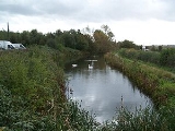
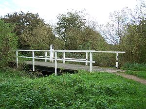
The canal today
Since 1977, the Broxtowe Borough CouncilBroxtowe
Broxtowe is a local government district with borough status in Nottinghamshire, England, west of the City of Nottingham. It is part of the Greater Nottingham metropolitan area...
has owned and maintained the upstream sections from Wollaton to Langley Mill as a nature reserve and walking trail. Much of the route is in water, although water supply is a problem. The Robinettes Arm acts as a feeder, taking water from Oldmoor Wood, but beyond this, a 3.2 kilometres (2 mi) section has been destroyed by open cast mining at Awsworth, cutting off the original water supplies from Giltbrook and Moorgreen reservoir. Because of the rich habitat that the route provides, it was declared a Local Nature Reserve in 1993. The downstream section through Nottingham and connecting to the River Trent
River Trent
The River Trent is one of the major rivers of England. Its source is in Staffordshire on the southern edge of Biddulph Moor. It flows through the Midlands until it joins the River Ouse at Trent Falls to form the Humber Estuary, which empties into the North Sea below Hull and Immingham.The Trent...
remains in use as part of the Beeston and Nottingham Canal.
The towpath of the canal through Nottingham city centre is also the route of Nottingham's Big Track, a 16 kilometres (9.9 mi) circular car free cycle and footpath, which follows the canal from the railway station in Nottingham to the Beeston locks, and then returns via the Trent riverside path.
Further reading
- Henshaw, A., (2000) "The Great Northern Railway in the East Midlands" RCTS
- Chell, B., (2006) "Nottingham Canal, A History and Guide" Tempus Publishing
- Zaleski, S., (2001) "The Nottingham Canal, Past and Present" The Local History Press