

Anel Viário José Magalhães Teixeira
Encyclopedia


Highway
A highway is any public road. In American English, the term is common and almost always designates major roads. In British English, the term designates any road open to the public. Any interconnected set of highways can be variously referred to as a "highway system", a "highway network", or a...
s surrounding the city of Campinas
Campinas
Campinas is a city and municipality located in the coastal interior of the state of São Paulo, Brazil. is the administrative center of the meso-region of the same name, with 3,783,597 inhabitants as of the 2010 Census, consisting of 49 cities....
, in the state of São Paulo
São Paulo (state)
São Paulo is a state in Brazil. It is the major industrial and economic powerhouse of the Brazilian economy. Named after Saint Paul, São Paulo has the largest population, industrial complex, and economic production in the country. It is the richest state in Brazil...
, Brazil
Brazil
Brazil , officially the Federative Republic of Brazil , is the largest country in South America. It is the world's fifth largest country, both by geographical area and by population with over 192 million people...
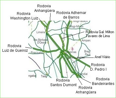
. The Campinas Beltway is the Northern vertex of the Macrometropolitan Highway System of Greater São Paulo and one of the few complete metropolitan beltways in the country. It is an extensive structure, which directly interconnects 6 large double-lane highways to all quadrants of the state. Furthermore, it is superdimensioned, i.e., it has enough capacity to accommodate huge traffic loads without getting congested, even in peak hours.
The beltway itself is formed by a short (13 km) connection between the highways Rodovia Anhangüera
Rodovia Anhangüera
Rodovia Anhangüera is a highway in the state of São Paulo, Brazil. It is one of the country's busiest transportation corridors...
and Rodovia Dom Pedro I
Rodovia Dom Pedro I
Rodovia Dom Pedro I is a highway in the state of São Paulo, Brazil.One of the best built and most scenic highways in the country, it interconnects the Anhangüera and the Presidente Dutra highways, serving the major cities of Campinas, Atibaia, Jacareí and São José dos Campos...
, and those highways. They encircle the urban core of Campinas, with a total length of 42 km.
The highways directly connected to the Campinas hub are:
- SP-340: Rodovia Adhemar de BarrosRodovia Adhemar de BarrosRodovia Adhemar de Barros is a highway in the state of São Paulo, Brazil. It is 170 km long.The highway runs in an almost perfect South-North direction, departing from the city of Campinas, then passing by Jaguariúna, Holambra, Santo Antônio da Posse, Mogi Guaçu, Mogi Mirim, Estiva Gerbi,...
to Mogi GuaçuMogi GuaçuMogi Guaçu is a municipality in the state of São Paulo in Brazil. The population as of 2008 was 141,559 people and these covered an area of 885.00 km². The city is at an average elevation of 591 m. Mogi Guaçu is a place name that probably originates from the Tupi language. It means "large...
, Mogi Mirim, AguaíAguaíAguaí is a Brazilian city located in the eastern part of the state of São Paulo.*Founder: Major João Joaquim Braga*Founded: November 30, 1948*Date of Anniversary: August 6-Limits:North...
, Casa BrancaCasa BrancaCasa Branca is a city in the state of São Paulo in Brazil. It was founded in 1841. In the last century, Casa Branca was denominated "Terra das Boçorocas"....
and MococaMococaMococa is a municipality in the state of São Paulo in Brazil. The population in 2004 is 69,629 and the area is 856.39 km². The elevation is 645 m.-External links:*...
. - SP-330: Rodovia AnhangüeraRodovia AnhangüeraRodovia Anhangüera is a highway in the state of São Paulo, Brazil. It is one of the country's busiest transportation corridors...
, from São Paulo City, JundiaiJundiaíJundiaí is a city and municipality in the state of São Paulo, Brazil. The population in 2009 was 349,929, and the area is 433.958 km². The elevation is 761 m. Distance is 60 km north of the city of São Paulo.- History and Geography :...
, LouveiraLouveiraLouveira is a municipality/county in the state of São Paulo in Brazil. The population in 2004 was 27,925 and the area is 55.418 km². The elevation is 690 m....
, VinhedoVinhedoVinhedo is a municipality in the state of São Paulo in Brazil. The population in 2004 was 54,194 and its area is 81.956 km². The elevation is 725 m. It was founded in 1949....
and ValinhosValinhosValinhos is a city and municipality in the state of São Paulo, Brazil. It is the birthplace of Adoniran Barbosa. Valinhos is famous for its purple fig, the theme of its annual Fig Fest. It is geographically close to Campinas. The city's estimated population in 2009 was107,481. Its area is...
to SumaréSumaréSumaré is a city in the State of São Paulo, Brazil. The population in 2004 was 225,308 and the area is 153.44 km². The elevation is 583 m. Sumaré was founded in 1868, after being upgraded to a city. Its old name was Rebouças. Major José Antonio Bacchim/2005/2008.- History :In the mid of 18th...
, AmericanaAmericanaAmericana refers to artifacts, or a collection of artifacts, related to the history, geography, folklore and cultural heritage of the United States. Many kinds of material fall within the definition of Americana: paintings, prints and drawings; license plates or entire vehicles, household objects,...
, LimeiraLimeiraLimeira is a city in the eastern part of the Brazilian state of São Paulo. The population in 2004 is 270,733 and the area is 582.48 km². The elevation is 588 m. It is 154 km far from São Paulo, the state capital, and 1011 km far from Brasilia, Brazil's capital...
, ArarasArarasAraras is a city and county in the State of São Paulo, Brazil. The population in 2010 is 118,898.-Sports:União São João Esporte Clube, founded in 1981, is the most successful football club of the city....
, LemeLemeLeme is a municipality in the state of São Paulo in Brazil. The area is 403.1 km². According to the 2000 census, it has 80,757 residents, 40,830 of whom are men and 39,927 women. 65,885 residents are 10 years old or older, and of these, 59,991, or 91.1%, are literate. The estimated population...
, PirassunungaPirassunungaPirassununga is a municipality in the state of São Paulo in Brazil. The population in 2010 was 70.081 and the area is 728.78 km². The elevation is 627 m. This place name comes from the Tupi language....
, Porto FerreiraPorto FerreiraPorto Ferreira is a municipality in the state of São Paulo in Brazil. The population in 2004 was 52,026 and the area is 244.88 km².It is situated to the edge of the river Mogi-Guaçu, at an altitude of 549 meters. Its population in 2006 was 54 000 inhabitants...
, CravinhosCravinhosCravinhos is a municipality in the state of São Paulo in Brazil. The population in 2004 is 31,412 and the area is 312.26 km². The elevation is 788 m....
, Ribeirão PretoRibeirão PretoRibeirão Preto is a municipality and city in the Northeastern region of the state of São Paulo in Brazil. It is nicknamed Brazilian California, because of a combination of an economy based on agrobusiness plus high technology, wealth and sunny weather all year long. With 605,114 inhabitants,...
, OrlândiaOrlândiaOrlândia is a municipality in the state of São Paulo in Brazil. The population in 2004 is 38,408 and the area is 297.29 km². The elevation is 695 m....
, São Joaquim da BarraSão Joaquim da BarraSão Joaquim da Barra is a municipality in the state of São Paulo in Brazil. The population in 2004 was 44,472 and the area is 413.49 km². The elevation is 625 m....
and ItuveravaItuveravaItuverava is a city in central Brazil, located north of the Sao Paulo state. Ituverava is about north of Sao Paulo, at an elevation of 605 meters above sea level. In 2008 the population was about 45,530 people.-Geography:...
. - SP-348: Rodovia dos BandeirantesRodovia dos BandeirantesRodovia Bandeirantes is a highway in the state of São Paulo, Brazil.Once the traffic capacity of Anhangüera Highway was exceeded in the 1960s, the state government decided to built another highway, with a much higher capacity and modern design, directly connecting São Paulo City to Jundiaí,...
, from São Paulo City to Campinas and there to HortolandiaHortolândiaHortolândia is a municipality in the state of São Paulo in Brazil. The population in 2008 is 201 049 and the area is 62,2 km². The elevation is 587 m....
, Santa Bárbara d'OesteSanta Bárbara d'OesteSanta Bárbara d'Oeste is a municipality in the state of São Paulo in Brazil. , it has a population of 189,573. The elevation is 570 meters....
and CordeirópolisCordeirópolisCordeirópolis is a small town in São Paulo state, Brazil. The town has 20,445 inhabitants, as of 2008....
, connecting to Rodovia Washington LuísRodovia Washington LuísRodovia Washington Luís is a highway in the state of São Paulo, Brazil.It runs in the North-Northwest direction, departing as a branch from the Anhangüera Highway near the city of Limeira...
. - SP-065: Rodovia Dom Pedro IRodovia Dom Pedro IRodovia Dom Pedro I is a highway in the state of São Paulo, Brazil.One of the best built and most scenic highways in the country, it interconnects the Anhangüera and the Presidente Dutra highways, serving the major cities of Campinas, Atibaia, Jacareí and São José dos Campos...
to ValinhosValinhosValinhos is a city and municipality in the state of São Paulo, Brazil. It is the birthplace of Adoniran Barbosa. Valinhos is famous for its purple fig, the theme of its annual Fig Fest. It is geographically close to Campinas. The city's estimated population in 2009 was107,481. Its area is...
, ItatibaItatibaItatiba is a county in the state of São Paulo in Brazil and distant approximately 70 km from the State Capital . The population in 2004 was 91,228 and the city has an area of 323.38 km². The average elevation is 750 m. The place's name comes from the Tupi Guarani language, and means "Many Rocks"...
, AtibaiaAtibaiaAtibaia is a Brazilian city located in the state of São Paulo, Brazil. The name is derived from an indigenous language called Tupi, and means "healthy water river". Its name has changed over time, from the primitive Tupi word Tybaia, to Thibaia, Atubaia, Thibaya, and finally the city's modern...
, Nazaré PaulistaNazaré PaulistaNazaré Paulista is a municipality in the state of São Paulo in Brazil. The population in 2004 is 15,815 and the area is 327.39 km². The elevation is 845 m. Nazaré Paulista borders the Atlantic Forest and is a major source of water for the city of São Paulo. Nazaré Pauilista is a relatively...
and JacareíJacareíJacareí is a city of approximately 211,308 inhabitants in the state of São Paulo, Brazil. The name comes from a native brazilan language . It's a word that means something like "the rivers where alligators are found"....
, connecting to Rodovia Presidente DutraRodovia Presidente DutraThe Rodovia Presidente Dutra, , colloquially known as Via Dutra is a federal highway which runs through the eastern part of the state of São Paulo and southwestern region of the state Rio de Janeiro...
. - SP-075: Rodovia Santos DumontRodovia Santos DumontRodovia Santos Dumont is a highway in the state of São Paulo, Brazil.It runs in a North-South direction and interconnects the cities of Campinas, Indaiatuba, Salto, Itu and Sorocaba, crossing with two other major highways, Rodovia Castelo Branco, nearby Sorocaba, and the Rodovia dos Bandeirantes...
to IndaiatubaIndaiatubaIndaiatuba is a municipality in the state of São Paulo in Brazil. The population in 2006 is 181,124 and has an area is 311.34 km². The elevation is 624 m. The city's name comes from the Tupi language. One of the most important city of the area....
, SaltoSaltoSalto may refer to:*Salto, a Latin word for "to leap/jump", and in gymnastics refers to a somersault* Glasflügel H-101 "Salto" -Organisations:...
, ItuItuItu is an old and historic municipality in the state of São Paulo in Brazil. The population in 2009 was 157,384 and the area is 641.68 km². The elevation is 583 m. This place name comes from the Tupi language, meaning big waterfall. Itu is linked with the highway numbered the SP-75 and are flowed...
and SorocabaSorocabaSorocaba is a city in the state of São Paulo, Brazil. Sorocaba is the fourth largest city in the state of São Paulo. Outside the Greater São Paulo region, it ranks behind only Campinas, Sao Jose dos Campos and Ribeirão Preto...
, connecting to Rodovia Castelo BrancoRodovia Castelo BrancoRodovia Presidente Castelo Branco is a tollway in the state of São Paulo, Brazil. It was first opened on November 10, 1968, by, then, the Governor of the state of São Paulo, Abreu Sodré...
and Rodovia Raposo TavaresRodovia Raposo TavaresRodovia Raposo Tavares is the longest highway in the state of São Paulo, Brazil, with 664 km.The highway starts in the city of São Paulo and continues westward, serving the main cities of Cotia, Vargem Grande Paulista, São Roque, Sorocaba, Itapetininga, Angatuba, Ourinhos, Assis, Presidente...
. - SP-332: Rodovia General Milton Tavares de SouzaRodovia General Milton Tavares de SouzaRodovia Professor Zeferino Vaz is a highway in the state of São Paulo, Brazil....
to PaulíniaPaulíniaPaulínia is a municipality in the state of São Paulo in Brazil. As of 2009, its population was 84.577 inhabitants in an area of 145.27 km². The elevation is 590 m...
. - SP-101: Rodovia Francisco Aguirre Proença to HortolândiaHortolândiaHortolândia is a municipality in the state of São Paulo in Brazil. The population in 2008 is 201 049 and the area is 62,2 km². The elevation is 587 m....
and Monte MorMonte MorMonte Mor is a municipality in the state of São Paulo in Brazil. The population in 2004 is 43,384 and the area is 241.49 km². The elevation is 560 m....
and thence to CapivariCapivariCapivari is a municipality in the state of São Paulo in Brazil. The population in 2003 was estimated 45,187 and the area is 324.47 km².-People:...
and RafardRafardRafard is a city in the state of São Paulo in Brazil. The population in 2004 was estimated 8,243 and the area is 132,82 km². The elevation is 515 m.-People:...
Less than 60 km from the hub, other important highways can be reached via high speed double-lane accesses from Campinas:
- SP-306: Rodovia Luiz de QueirozRodovia Luiz de QueirozRodovia Luiz de Queiroz is a highway in the state of São Paulo, Brazil.It interconnects the cities of Americana, by the Anhanguera Highway and Piracicaba, serving also the city of Santa Bárbara d'Oeste, at which level crosses with the Rodovia dos Bandeirantes...
, to PiracicabaPiracicabaPiracicaba is a city located in the Brazilian state of São Paulo. The population in 2009 was 368,843 in an area of 1,369.511 km², at an elevation of 547 m above sea level.-Name:...
. - SP-310: Rodovia Washington LuísRodovia Washington LuísRodovia Washington Luís is a highway in the state of São Paulo, Brazil.It runs in the North-Northwest direction, departing as a branch from the Anhangüera Highway near the city of Limeira...
, to Rio ClaroRio Claro, São PauloRio Claro is a city in the state of São Paulo in Brazil. The population in 2005 was 195,131 and the area is 521 km². The elevation is 613 m. It was incorporated as the village of São João Batista do Ribeirão Claro in 1827, and this incorporation is celebrated every year on June 24 as a municipal...
, São CarlosSão CarlosSão Carlos is a city of 221,950 inhabitants in the state of São Paulo, Brazil. It is located at , at about 231 km from the city of São Paulo.-History:...
, AraraquaraAraraquaraNot to be confused with Araracuara, a town, region, genus of trees in ColombiaAraraquara is a city in the state of São Paulo in Brazil. It is also known as "the abode of the sun," because of its impressive sunset and because of its hazy temperature, especially in summer.More than 200,000 people...
, CatanduvaCatanduvaCatanduva is a municipality in the state of São Paulo, Brazil. Is the 2nd largest city in the North/Northwest portion of the state, 385 km from the city of São Paulo...
, São José do Rio PretoSão José do Rio PretoSão José do Rio Preto is a city and municipality in the state of São Paulo, Brazil. Is located at the north/northwest portion of the state, 450 km from the city of São Paulo and 700 km from Brasília....
and MirassolMirassolMirassol is a city and municipality in the state of São Paulo, Brazil. The city is located on the north/northwest portion of the state, 463 km from the city of São Paulo and 15 km from São José do Rio Preto...
, connecting to the Rodovia TransbrasilianaRodovia TransbrasilianaRodovia Transbrasiliana is a federal highway in Brazil .It crosses Brazil in the North-South direction, starting in Marabá, state of Pará and ending in Aceguá, in the state of Rio Grande do Sul...
. - BR-381: Rodovia Fernão DiasRodovia Fernão DiasThe Rodovia Fernão Dias is a federal highway which runs in the Brazilian states of São Paulo and southern region of Minas Gerais...
, to the state of Minas GeraisMinas GeraisMinas Gerais is one of the 26 states of Brazil, of which it is the second most populous, the third richest, and the fourth largest in area. Minas Gerais is the Brazilian state with the largest number of Presidents of Brazil, the current one, Dilma Rousseff, being one of them. The capital is the...
and Belo HorizonteBelo HorizonteBelo Horizonte is the capital of and largest city in the state of Minas Gerais, located in the southeastern region of Brazil. It is the third largest metropolitan area in the country...
.
Through São Paulo City, the Campinas Beltway connects to the Southern vertex of the Macrometropolitan Ring of Sâo Paulo, to highways Rodovia dos Imigrantes
Rodovia dos Imigrantes
Rodovia dos Imigrantes is a highway in the state of São Paulo, Brazil.The highway connects the city of São Paulo to the Atlantic coast and with the seaside cities of São Vicente and Praia Grande. It follows the route of Rodovia Anchieta and is also one of Brazil's busiest highways, particularly on...
, Rodovia Anchieta
Rodovia Anchieta
Rodovia Anchieta is a highway connection between São Paulo and the Atlantic coast, the cities of Cubatão and Santos, in Brazil...
and Rodovia Régis Bittencourt
Rodovia Régis Bittencourt
Rodovia Régis Bittencourt is a section of the BR-116 that connects the cities of São Paulo and Curitiba, Brazil. It is considered one of the most dangerous highways of Brazil, due to the high number of accidents. Sometimes it is even nicknamed "Rodovia da Morte" . It also leads the number of...
.
The greatest part of the Campinas Beltway runs inside the urban zone (i.e., there are several highly populated sections of the cities of Campinas and Valinhos on the outside of the ring), thus its traffic is quite high. The highways which are part of it are now for all practical purposes used like urban avenues, with dozens of points of entrance, bridgeworks, viaduct
Viaduct
A viaduct is a bridge composed of several small spans. The term viaduct is derived from the Latin via for road and ducere to lead something. However, the Ancient Romans did not use that term per se; it is a modern derivation from an analogy with aqueduct. Like the Roman aqueducts, many early...
s, vicinal roads and streets, etc. The segments which comprise the ring are not tolled
Toll road
A toll road is a privately or publicly built road for which a driver pays a toll for use. Structures for which tolls are charged include toll bridges and toll tunnels. Non-toll roads are financed using other sources of revenue, most typically fuel tax or general tax funds...
, due to a prohibition by the municipality of Campinas.
The region surrounding the beltway has one of the highest rates of urban growth and development in the city. Many high-technology companies have established their factories and offices alongside the Ring's highways, such as Lucent and Samsung
Samsung
The Samsung Group is a South Korean multinational conglomerate corporation headquartered in Samsung Town, Seoul, South Korea...
. The majority of the city's shopping mall
Shopping mall
A shopping mall, shopping centre, shopping arcade, shopping precinct or simply mall is one or more buildings forming a complex of shops representing merchandisers, with interconnecting walkways enabling visitors to easily walk from unit to unit, along with a parking area — a modern, indoor version...
s are also located along the Ring, such as the Dom Pedro, Campinas Outlet, Galleria
Shopping Galleria de Campinas
The Shopping Galleria de Campinas is a shopping mall located in Campinas, state of São Paulo, Brazil. It was the first open sky mall in Brazil. The Shopping is located by the Rodovia Dom Pedro I in the outskirts of the city....
and Iguatemi malls. In addition, the Ring's Northern and Eastern sections have witnessed a large and fast growth of luxury horizontal condominia, such as Alphaville
Alphaville, São Paulo
Alphaville is the commercial name of a real estate and gated communities development in Brazil and Portugal, constituted by a number of business and residential condominia. The name evokes the "first among cities" concept...
and Gramado.
The structure is so named in honour of deceased, twice mayor
Mayor
In many countries, a Mayor is the highest ranking officer in the municipal government of a town or a large urban city....
of Campinas, Dr. José Roberto Magalhães Teixeira
José Roberto Magalhães Teixeira
José Roberto Magalhães Teixeira was a Brazilian politician, twice mayor of the municipality of Campinas, in the state of São Paulo.Born in Andradas, state of Minas Gerais, on 18 June 1937, he moved to Campinas in 1957, in order to study dentistry at the Pontifical Catholic University...
.
See also
- Highway system of São PauloHighway system of São PauloThe highway system of São Paulo is the largest statewide road transportation system in Brazil, with 34,650 km. It consists of a hugely interconnected network of municipal , state and federal roads...
- Highways serving Campinas (In Portuguese)