

Anacostia Historic District
Encyclopedia
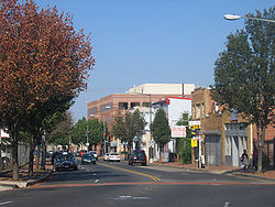
The Anacostia Historic District is a historic district
in the city of Washington, D.C.
, comprising approximately 20 squares and about 550 buildings built between 1854 and 1930. The Anacostia Historic District was added to the National Register of Historic Places
in 1978. "The architectural character of the Anacostia area is unique in Washington. Nowhere else in the District of Columbia does there exist such a collection of late-ninetheenth and early-twentieth century small-scale frame and brick working-class housing."
The historic district is roughly bounded by:
Buildings within the Anacostia Historic District are generally two-story brick and wood frame structures. The houses are primarily wood frame construction, mostly in the Italianate
, Cottage
, and Washington Row House architectural styles (although there are some homes in the Queen Anne
style). Cottage style buildings tend to have been built earlier, with Italianate structures more popular after 1870. Queen Anne-style homes tend to be clustered in Griswold's subdivision. Many of the homes feature large lawn
s and wrap-around porch
es.
 The Nacotchtank
Native Americans
were the first settlers to inhabit the area now known as Anacostia, living and fishing along the Anacostia River
. Captain John Smith was the first Europe
an to visit the region in 1612 C.E.
, naming the river the "Nacotchtank". Henry Fleet (an English
explorer kidnapped for five years by the Nacotchtank beginning in 1621) and Leonard Calvert
(later Governor
of the Province of Maryland
) gave the area its more etymologically correct name, "Anacostine," from which the modern name of Anacostia is derived. The name means "trading village," and the Nacochtank villages which dotted the south side of the Anacostia River were busy trading sites for Native Americans in the region. War and disease decimated the Nacochtank, and during the last 25 years of the 17th century the tribe ceased to exist as a functional unit and its few remaining members merged with other local Piscataway
tribes.
European settlement first occurred in the area in 1662 at Blue Plains (now the site of the city's sewage treatment
plant just to the west of the modern neighborhood of Bellevue
), and at St. Elizabeth (now the site of St. Elizabeths Hospital
psychiatric hospital
) and Giesborough (now called Barry Farm
) in 1663. In 1663, Lord Baltimore
granted ownership of the majority of the area on the south bank of the Anacostia River to George Thompson. Slightly inland, Lord Baltimore granted another large tract (known as Chichester) to John Meeks in 1664. "Anacostia Fort" was built on the heights at the present-day neighborhood of Skyland
some time in the 18th century.
The area became part of the District of Columbia in 1791. Congress passed the Residence Act of 1790 to establish a federally-owned district in which would be built the new national capital, and George Washington
picked the current site in 1791 (a choice ratified by Congress later that year). In 1795, real estate speculator James Greenleaf purchased most of what is now the Anacostia Historic District from federal government. Although Greenleaf was bankrupted in the Panic of 1796–1797, a few homes dotted the shores of the eastern bank of Anacostia River in what is now the historic district. William Marbury
, a wealthy Georgetown
merchant who later was a party in the landmark Marbury v. Madison
Supreme Court
case, purchased much of the land that is now the Anacostia Historic District some time in the late 18th century or early 19th century.
The first permanent modern settlement of size in the Anacostia Historic District came in 1820. The growth of the Washington Navy Yard
created the need to provide housing for the many new employees working at the facility, but little land was available for new construction in the area and housing prices were high. Consequently, in 1818, the privately owned "Upper Navy Yard Bridge
" was built over the Anacostia River at 11th Street SE. A toll bridge
, this bridge was designed to permit easy access to Anacostia so that housing could be constructed on the eastern shore of the Anacostia River. Prior to the construction of this bridge and others upstream, there were no mudflat
s along the banks of the Anacostia. The bridges shifted currents and slowed the flow of the river, and within a decade extensive flats had built up along the shore. In 1820, the town of Good Hope, D.C., was founded around a tavern located near the current intersection of Good Hope Road SE and Alabama Avenue SE (forming the current neighborhood of Good Hope
). Businesses began to construct buildings along Upper Marlborough Road (called Good Hope Road SE today) toward the village of Good Hope, forming the Anacostia Business District. In the late 1820s or early 1830s, Marbury sold his land to Enoch Tucker, who rented out part of the land to tenant farmer
s and built his home near the intersection of Upper Marlborough Road and Piscataway Road (now Martin Luther King, Jr. Avenue SE). A post office
was established in the area and named Good Hope Station. In 1849, the post office's name was changed to Anacostia.
) stood there. Half the lots sold within two months of the first sale. Restrictive covenant
s prohibited the sale or lease of property to anyone of African descent
, Mulatto
es, or Irish
. The main street in the 17-block subdivision (bordered by Martin Luther King, Jr. Avenue SE, Good Hope Road SE, 16th Street SE, and W Street SE) was 14th Street SE, which had a central market and a 40-foot (12.2 metre) wide boulevard running down the center of it.
The first house erected in the new subdivision was a two-story brick building on Harrison Street (on the southwest corner of Harrison and Monroe Streets), and next to it on Monroe Street (on the site of the former Enoch Tucker farmhouse) rose a brick structure which held George F. Pyle's grocery store. In 1855, Van Hook himself built "Cedar Hill
", a lavish mansion on Jefferson Street near the Fox Mansion. Dr. Arthur Christie, a wealthy Englishman, purchased 50 acres (20.25 hectares) of land on the north side of Harrison Street and named his estate Fairlawn. Lewin Talburtt built a spectacular 21-room mansion, "Mont View," on what is now Mount View Place SE; his son, George Washington Talburtt, lived there for many years (although it is an apocrypha
l story that John Howard Payne
composed the song Home! Sweet Home!
there). The first church in the area, the Episcopalian
"Ryan's Chapel," opened in 1862.
 Van Hook had hoped to attract Navy Yard workers to buy and build in the Uniontown development. But although most of the lots had sold by 1860, the Panic of 1857
and the Civil War
hindered building and few houses were constructed. The Civil War itself brought many changes to the area encompassed by the Anacostia Historic District. After the First Battle of Bull Run
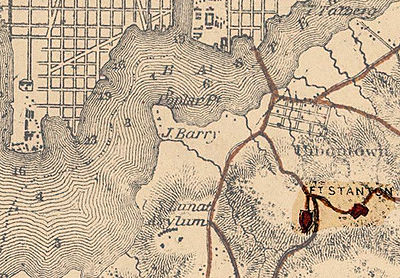
, Northern military leaders realized Washington, D.C., was relatively undefended and quickly began building a ring of forts around the city. The first of these forts was Fort Stanton
, which began construction in September 1861, was completed on October 22, and fully armed and staffed by December 25. Fort Stanton was built on "Garfield Heights" (now Fort Stanton Park), and a military road (now Morris Road SE, Erie Street SE, Fort Place SE, Bruce Place SE, and Ainger Place SE) constructed from Monroe Street to provide better access to the river and Navy Yard Bridge (11th Street Bridges) and to link Fort Stanton with its subsidiary batteries, Fort Ricketts and Fort Snyder, and nearby Fort Wagner (now the site of Stanton Elementary School). The area was officially named Uniontown in 1865, but there was so much confusion between the village and Uniontown, Pennsylvania
that the name of the area reverted back to Anacostia on April 22, 1866. Fort Stanton closed in April 1866, and the land it occupied was turned back over to private ownership. The structures of the fort itself remained, falling into decay.
The Union Land Association went bankrupt in the Panic of 1873
, and Van Hook was forced to sell Cedar Hill. The mansion was purchased by Frederick Douglass
in 1877, who defied the whites-only covenant governing the subdivision in buying the property. The 1880 census
shows that about 15 percent of Uniontown's residents were African American
.
The area also saw a number of civic improvements. Horse-drawn streetcar
service reached the area in 1875, 13 years after the rest of the city had achieved service, and electric streetcars arrived in 1895. St. Teresa's Catholic Church was built at 1244 V Street SE in 1879, and Emanuel Episcopal Church (now Delaware Avenue Baptist Church) at 1301 V Street SE was erected in 1891 to replace an 1869 church whose foundation had cracked. The 11th Precinct of the Metropolitan Police Department
was established in 1901 to patrol the area, the Ketcham School
(now Ketcham Elementary School) was built in 1907, and water and sewage service installed between 1904 and 1920. Nonetheless, water and sewage service in the area remained spotty, and some homes drew water from public standpipes as late as the 1960s. Congress integrated the Anacostia area into the city of Washington in 1908, at which time the streets in the area were given their current names. In 1920, local African-American Roman Catholics constructed Our Lady of Perpetual Help church on land formerly owned by physician J.C. Norwood. The Fort Stanton site was purchased by National Capital Park Commission
(NCPC) for $56,000 in 1926.
Development Southeast Washington was not pursued much after 1900. In 1867, Major General
Oliver Otis Howard, commissioner in charge of the Bureau of Refugees, Freedmen and Abandoned Lands
, purchased John Barry's farm immediately southwest of Uniontown/Anacostia, subdivided the property, and sold small lots at rock-bottom prices to freed slaves (establishing the neighborhood of Barry Farm
. Businessman Arthur Randle purchased the John Jay Knox farm south of St. Elizabeths Aslyum and established the new subdivision of Congress Heights in 1890. He purchased undeveloped land south of Pennsylvania Avenue SE and created another new subdivisions, Randle Highlands Uniontown/Anacostia, Barry Farm, Congress Heights, and Randle Highlands remained isolated from one another, and most of the land between them was undeveloped, until World War II
. The oppressive need for housing during the war, brought by a massive influx of federal workers to the capital, led to extensive development of the region and the linking of the area encompassed by the Anacostia Historic District with other parts of Southeast D.C. Only 16 percent of the homes in Southeast Washington below Pennsylvania Avenue SE were built prior to 1940, but 38 percent were built after 1950.
Suburbanization
dramatically changed the area in the 1960s and 1970s. The Anacostia neighborhood, which had been 82.4 percent white in 1950, was only 67.7 percent white in 1960 and 86 percent black by 1970. The influx of large numbers of low-income African Americans, coupled with the economic dislocations caused by the 1968 Martin Luther King, Jr. assassination riots
, led many businesses to leave the Anacostia business district. During the crack epidemic in Washington in the 1980s, the Anacostia neighborhood became synonymous with crime and violence, and had one of the highest crime rates in the District of Columbia (albeit not in all crimes)—leading to further deterioration in the condition of the buildings in the area.
's Green Line
was originally designed to pass over the 11th Street Bridges
to the intersection of Good Hope Road SE and Martin Luther King, Jr. Avenue SE. The site of the Anacostia Station
at this intersection led to concerns that the Metro station would destroy the character of historic Anacostia, and after pressure from the federal government Metro moved the site of the station to Howard Road SE.
The Anacostia Historic District was added to the National Register of Historic Places in 1978. After the 1990 census required the District government to redistrict
the borders of its electoral districts (wards), a proposal was made to split the Anacostia Historic District between Ward 7 and Ward 8. This proposal was defeated.
Efforts have been made to improve the physical and economic conditions in the Historic District. The area's designation as a historic district has been used to prevent the McDonald's
corporation from moving into the area, the relocation of a homeless shelter
to the area, and the construction of moderate-income rowhouses. In 1992, the city began replacing concrete sidewalks in the Anacostia Historic District with red brick to restore the sidewalks to their original condition. In 2002, the city adopted the Historic Housing Tax Credit Act of 2002, which allowed homeowners in the historic district to claim a tax credit of 50 percent of the cost of renovating their home (up to a limit of $25,000 over five years). Five years later, the D.C. Historic Preservation Office provided $300,000 in $35,000 individual grants to Anacostia residents to help them restore, renovate, and rehabilitate their homes. In 2008, the city increased the budget for the grant program to $900,000.
Historic district (United States)
In the United States, a historic district is a group of buildings, properties, or sites that have been designated by one of several entities on different levels as historically or architecturally significant. Buildings, structures, objects and sites within a historic district are normally divided...
in the city of Washington, D.C.
Washington, D.C.
Washington, D.C., formally the District of Columbia and commonly referred to as Washington, "the District", or simply D.C., is the capital of the United States. On July 16, 1790, the United States Congress approved the creation of a permanent national capital as permitted by the U.S. Constitution....
, comprising approximately 20 squares and about 550 buildings built between 1854 and 1930. The Anacostia Historic District was added to the National Register of Historic Places
National Register of Historic Places
The National Register of Historic Places is the United States government's official list of districts, sites, buildings, structures, and objects deemed worthy of preservation...
in 1978. "The architectural character of the Anacostia area is unique in Washington. Nowhere else in the District of Columbia does there exist such a collection of late-ninetheenth and early-twentieth century small-scale frame and brick working-class housing."
The historic district is roughly bounded by:
- Martin Luther King, Jr. AvenueMartin Luther King, Jr. AvenueMartin Luther King, Jr. Avenue is a major street in the District of Columbia traversing through both the Southwest and Southeast quadrants.-Route:...
SE between Good Hope Road SE and Morris Road SE; - Good Hope Road SE from Martin Luther King, Jr. Avenue SE to Fendall Street SE;
- Fendall Street SE from Good Hope Road SE to V Street SE;
- V Street SE between Fendall Street SE and 15th Street SE;
- 15th Street SE from V Street SE, along the eastern and southern sides of the Frederick Douglass National Historic SiteFrederick Douglass National Historic SiteThe Frederick Douglass National Historic Site, administered by the National Park Service, is located at 1411 W St., SE in Anacostia, a neighborhood east of the Anacostia River in Southeast Washington, D.C.. Established in 1988 as a National Historic Site, the site preserves the home and estate of...
to High Street SE; - High Street SE from 14th Street SE to Maple View Place SE; and
- Maple View Place SE between High Street SE and Martin Luther King, Jr. Avenue SE.
Buildings within the Anacostia Historic District are generally two-story brick and wood frame structures. The houses are primarily wood frame construction, mostly in the Italianate
Italianate architecture
The Italianate style of architecture was a distinct 19th-century phase in the history of Classical architecture. In the Italianate style, the models and architectural vocabulary of 16th-century Italian Renaissance architecture, which had served as inspiration for both Palladianism and...
, Cottage
Carpenter Gothic
Carpenter Gothic, also sometimes called Carpenter's Gothic, and Rural Gothic, is a North American architectural style-designation for an application of Gothic Revival architectural detailing and picturesque massing applied to wooden structures built by house-carpenters...
, and Washington Row House architectural styles (although there are some homes in the Queen Anne
Queen Anne Style architecture
The Queen Anne Style in Britain means either the English Baroque architectural style roughly of the reign of Queen Anne , or a revived form that was popular in the last quarter of the 19th century and the early decades of the 20th century...
style). Cottage style buildings tend to have been built earlier, with Italianate structures more popular after 1870. Queen Anne-style homes tend to be clustered in Griswold's subdivision. Many of the homes feature large lawn
Lawn
A lawn is an area of aesthetic and recreational land planted with grasses or other durable plants, which usually are maintained at a low and consistent height. Low ornamental meadows in natural landscaping styles are a contemporary option of a lawn...
s and wrap-around porch
Porch
A porch is external to the walls of the main building proper, but may be enclosed by screen, latticework, broad windows, or other light frame walls extending from the main structure.There are various styles of porches, all of which depend on the architectural tradition of its location...
es.
History of the district
Nacotchtank
The Nacotchtank were a native Algonquian people who lived in the area of what is now Washington, D.C. during the 17th century. Their principal village was situated within the modern borders of the District of Columbia, on the eastern bank of a small river that still bears an anglicised variant of...
Native Americans
Native Americans in the United States
Native Americans in the United States are the indigenous peoples in North America within the boundaries of the present-day continental United States, parts of Alaska, and the island state of Hawaii. They are composed of numerous, distinct tribes, states, and ethnic groups, many of which survive as...
were the first settlers to inhabit the area now known as Anacostia, living and fishing along the Anacostia River
Anacostia River
The Anacostia River is a river in the Mid Atlantic region of the United States. It flows from Prince George's County in Maryland into Washington, D.C., where it joins with the Washington Channel to empty into the Potomac River at Buzzard Point. It is approximately long...
. Captain John Smith was the first Europe
Europe
Europe is, by convention, one of the world's seven continents. Comprising the westernmost peninsula of Eurasia, Europe is generally 'divided' from Asia to its east by the watershed divides of the Ural and Caucasus Mountains, the Ural River, the Caspian and Black Seas, and the waterways connecting...
an to visit the region in 1612 C.E.
Common Era
Common Era ,abbreviated as CE, is an alternative designation for the calendar era originally introduced by Dionysius Exiguus in the 6th century, traditionally identified with Anno Domini .Dates before the year 1 CE are indicated by the usage of BCE, short for Before the Common Era Common Era...
, naming the river the "Nacotchtank". Henry Fleet (an English
United Kingdom
The United Kingdom of Great Britain and Northern IrelandIn the United Kingdom and Dependencies, other languages have been officially recognised as legitimate autochthonous languages under the European Charter for Regional or Minority Languages...
explorer kidnapped for five years by the Nacotchtank beginning in 1621) and Leonard Calvert
Leonard Calvert
Leonard Calvert was the 1st Proprietary Governor of Maryland. He was the second son of George Calvert, 1st Baron Baltimore, the first proprietary of the Province of Maryland...
(later Governor
Governor of Maryland
The Governor of Maryland heads the executive branch of the government of Maryland, and he is the commander-in-chief of the state's National Guard units. The Governor is the highest-ranking official in the state, and he has a broad range of appointive powers in both the State and local governments,...
of the Province of Maryland
Province of Maryland
The Province of Maryland was an English and later British colony in North America that existed from 1632 until 1776, when it joined the other twelve of the Thirteen Colonies in rebellion against Great Britain and became the U.S...
) gave the area its more etymologically correct name, "Anacostine," from which the modern name of Anacostia is derived. The name means "trading village," and the Nacochtank villages which dotted the south side of the Anacostia River were busy trading sites for Native Americans in the region. War and disease decimated the Nacochtank, and during the last 25 years of the 17th century the tribe ceased to exist as a functional unit and its few remaining members merged with other local Piscataway
Piscataway (tribe)
The Piscataway are a subtribe of the Conoy Native American tribe of Maryland. At one time, they were one of the most populous and powerful Native polities of the Chesapeake Bay region. They spoke Algonquian Piscataway, a dialect of Nanticoke...
tribes.
European settlement first occurred in the area in 1662 at Blue Plains (now the site of the city's sewage treatment
Sewage treatment
Sewage treatment, or domestic wastewater treatment, is the process of removing contaminants from wastewater and household sewage, both runoff and domestic. It includes physical, chemical, and biological processes to remove physical, chemical and biological contaminants...
plant just to the west of the modern neighborhood of Bellevue
Bellevue, Washington, D.C.
Bellevue is a residential neighborhood located in Southwest Washington, D.C, east of Bolling Air Force Base. It is bounded by Martin Luther King, Jr. Avenue SW to the west and northwest, Joliet Street SW to the south, and First Street and South Capitol Street on the east. There are many garden...
), and at St. Elizabeth (now the site of St. Elizabeths Hospital
St. Elizabeths Hospital
St. Elizabeths Hospital is a psychiatric hospital operated by the District of Columbia Department of Mental Health. It was the first large-scale, federally-run psychiatric hospital in the United States. Housing several thousand patients at its peak, St. Elizabeths had a fully functioning...
psychiatric hospital
Psychiatric hospital
Psychiatric hospitals, also known as mental hospitals, are hospitals specializing in the treatment of serious mental disorders. Psychiatric hospitals vary widely in their size and grading. Some hospitals may specialise only in short-term or outpatient therapy for low-risk patients...
) and Giesborough (now called Barry Farm
Barry Farm, Washington, D.C.
Barry Farm is a small neighborhood in Southeast Washington, D.C., adjacent to St. Elizabeths Hospital. Possibly the oldest African American neighborhood in Washington, it is today almost entirely occupied by public housing projects and has a reputation for violent crime, poverty, and neglect...
) in 1663. In 1663, Lord Baltimore
Cecilius Calvert, 2nd Baron Baltimore
Cecilius Calvert, 2nd Baron Baltimore, 1st Proprietor and 1st Proprietary Governor of Maryland, 9th Proprietary Governor of Newfoundland , was an English peer who was the first proprietor of the Province of Maryland. He received the proprietorship after the death of his father, George Calvert, the...
granted ownership of the majority of the area on the south bank of the Anacostia River to George Thompson. Slightly inland, Lord Baltimore granted another large tract (known as Chichester) to John Meeks in 1664. "Anacostia Fort" was built on the heights at the present-day neighborhood of Skyland
Skyland, Washington, D.C.
Skyland is a neighborhood in Southeast Washington, D.C. It is bounded by Good Hope Road to the northeast, Alabama Avenue to the southeast, and Fort Stanton Park to the south and west...
some time in the 18th century.
The area became part of the District of Columbia in 1791. Congress passed the Residence Act of 1790 to establish a federally-owned district in which would be built the new national capital, and George Washington
George Washington
George Washington was the dominant military and political leader of the new United States of America from 1775 to 1799. He led the American victory over Great Britain in the American Revolutionary War as commander-in-chief of the Continental Army from 1775 to 1783, and presided over the writing of...
picked the current site in 1791 (a choice ratified by Congress later that year). In 1795, real estate speculator James Greenleaf purchased most of what is now the Anacostia Historic District from federal government. Although Greenleaf was bankrupted in the Panic of 1796–1797, a few homes dotted the shores of the eastern bank of Anacostia River in what is now the historic district. William Marbury
William Marbury
William Marbury was one of the famous "Midnight Judges". Due to President John Adams's work in the night before he was to leave office, Marbury was to be appointed a Justice of the Peace in the District of Columbia. He was appointed there to give the Federalists a stronghold in the judicial...
, a wealthy Georgetown
Georgetown, Washington, D.C.
Georgetown is a neighborhood located in northwest Washington, D.C., situated along the Potomac River. Founded in 1751, the port of Georgetown predated the establishment of the federal district and the City of Washington by 40 years...
merchant who later was a party in the landmark Marbury v. Madison
Marbury v. Madison
Marbury v. Madison, is a landmark case in United States law and in the history of law worldwide. It formed the basis for the exercise of judicial review in the United States under Article III of the Constitution. It was also the first time in Western history a court invalidated a law by declaring...
Supreme Court
Supreme Court of the United States
The Supreme Court of the United States is the highest court in the United States. It has ultimate appellate jurisdiction over all state and federal courts, and original jurisdiction over a small range of cases...
case, purchased much of the land that is now the Anacostia Historic District some time in the late 18th century or early 19th century.
The first permanent modern settlement of size in the Anacostia Historic District came in 1820. The growth of the Washington Navy Yard
Washington Navy Yard
The Washington Navy Yard is the former shipyard and ordnance plant of the United States Navy in Southeast Washington, D.C. It is the oldest shore establishment of the U.S. Navy...
created the need to provide housing for the many new employees working at the facility, but little land was available for new construction in the area and housing prices were high. Consequently, in 1818, the privately owned "Upper Navy Yard Bridge
11th Street Bridges
The 11th Street Bridges are a pair of one-way bridges across the Anacostia River in Washington, D.C., U.S.A. The southbound structure is officially named the Officer Kevin J. Welsh Memorial Bridge, while the northbound structure is officially named the 11th Street Bridge. The bridges convey...
" was built over the Anacostia River at 11th Street SE. A toll bridge
Toll bridge
A toll bridge is a bridge over which traffic may pass upon payment of a toll, or fee.- History :The practice of collecting tolls on bridges probably harks back to the days of ferry crossings where people paid a fee to be ferried across stretches of water. As boats became impractical to carry large...
, this bridge was designed to permit easy access to Anacostia so that housing could be constructed on the eastern shore of the Anacostia River. Prior to the construction of this bridge and others upstream, there were no mudflat
Mudflat
Mudflats or mud flats, also known as tidal flats, are coastal wetlands that form when mud is deposited by tides or rivers. They are found in sheltered areas such as bays, bayous, lagoons, and estuaries. Mudflats may be viewed geologically as exposed layers of bay mud, resulting from deposition of...
s along the banks of the Anacostia. The bridges shifted currents and slowed the flow of the river, and within a decade extensive flats had built up along the shore. In 1820, the town of Good Hope, D.C., was founded around a tavern located near the current intersection of Good Hope Road SE and Alabama Avenue SE (forming the current neighborhood of Good Hope
Good Hope, Washington, D.C.
Good Hope is a residential neighborhood in southeast Washington, D.C, near Anacostia. The neighborhood is generally middle class and is dominated by single-family detached and semi-detached homes. The year-round Fort Dupont Ice Arena skating rink and the Smithsonian Institution's Anacostia Museum...
). Businesses began to construct buildings along Upper Marlborough Road (called Good Hope Road SE today) toward the village of Good Hope, forming the Anacostia Business District. In the late 1820s or early 1830s, Marbury sold his land to Enoch Tucker, who rented out part of the land to tenant farmer
Tenant farmer
A tenant farmer is one who resides on and farms land owned by a landlord. Tenant farming is an agricultural production system in which landowners contribute their land and often a measure of operating capital and management; while tenant farmers contribute their labor along with at times varying...
s and built his home near the intersection of Upper Marlborough Road and Piscataway Road (now Martin Luther King, Jr. Avenue SE). A post office
Post office
A post office is a facility forming part of a postal system for the posting, receipt, sorting, handling, transmission or delivery of mail.Post offices offer mail-related services such as post office boxes, postage and packaging supplies...
was established in the area and named Good Hope Station. In 1849, the post office's name was changed to Anacostia.
Uniontown
Developers John Dobler, John Fox, and John W. Van Hook purchased the 240-acre (97.2 hectare) area known as Anacostia from Enoch Tucker on June 5, 1854, for $19,000 and immediately subdivided the property into lots for houses. Fox had built a mansion on Jefferson Street (now W Street SE) some years before, and Fox and Van Hook were business partners in the Union Land Association. Naming the area Uniontown, the development became Washington's first "suburban" community. Van Hook (the lead developer) renamed streets in the area after former presidents: Upper Marlborough Road was now called "Harrison Street," and Piscataway Road now known as "Monroe Street". The area between Monroe Street and the Anacostia River was known as the Duvall subdivision, and Duvall's Tavern (a well-known barBar (establishment)
A bar is a business establishment that serves alcoholic drinks — beer, wine, liquor, and cocktails — for consumption on the premises.Bars provide stools or chairs that are placed at tables or counters for their patrons. Some bars have entertainment on a stage, such as a live band, comedians, go-go...
) stood there. Half the lots sold within two months of the first sale. Restrictive covenant
Restrictive covenant
A restrictive covenant is a type of real covenant, a legal obligation imposed in a deed by the seller upon the buyer of real estate to do or not to do something. Such restrictions frequently "run with the land" and are enforceable on subsequent buyers of the property...
s prohibited the sale or lease of property to anyone of African descent
African people
African people refers to natives, inhabitants, or citizen of Africa and to people of African descent.-Etymology:Many etymological hypotheses that have been postulated for the ancient name "Africa":...
, Mulatto
Mulatto
Mulatto denotes a person with one white parent and one black parent, or more broadly, a person of mixed black and white ancestry. Contemporary usage of the term varies greatly, and the broader sense of the term makes its application rather subjective, as not all people of mixed white and black...
es, or Irish
Irish people
The Irish people are an ethnic group who originate in Ireland, an island in northwestern Europe. Ireland has been populated for around 9,000 years , with the Irish people's earliest ancestors recorded having legends of being descended from groups such as the Nemedians, Fomorians, Fir Bolg, Tuatha...
. The main street in the 17-block subdivision (bordered by Martin Luther King, Jr. Avenue SE, Good Hope Road SE, 16th Street SE, and W Street SE) was 14th Street SE, which had a central market and a 40-foot (12.2 metre) wide boulevard running down the center of it.
The first house erected in the new subdivision was a two-story brick building on Harrison Street (on the southwest corner of Harrison and Monroe Streets), and next to it on Monroe Street (on the site of the former Enoch Tucker farmhouse) rose a brick structure which held George F. Pyle's grocery store. In 1855, Van Hook himself built "Cedar Hill
Frederick Douglass National Historic Site
The Frederick Douglass National Historic Site, administered by the National Park Service, is located at 1411 W St., SE in Anacostia, a neighborhood east of the Anacostia River in Southeast Washington, D.C.. Established in 1988 as a National Historic Site, the site preserves the home and estate of...
", a lavish mansion on Jefferson Street near the Fox Mansion. Dr. Arthur Christie, a wealthy Englishman, purchased 50 acres (20.25 hectares) of land on the north side of Harrison Street and named his estate Fairlawn. Lewin Talburtt built a spectacular 21-room mansion, "Mont View," on what is now Mount View Place SE; his son, George Washington Talburtt, lived there for many years (although it is an apocrypha
Apocrypha
The term apocrypha is used with various meanings, including "hidden", "esoteric", "spurious", "of questionable authenticity", ancient Chinese "revealed texts and objects" and "Christian texts that are not canonical"....
l story that John Howard Payne
John Howard Payne
John Howard Payne was an American actor, poet, playwright, and author who had most of his theatrical career and success in London. He is today most remembered as the creator of "Home! Sweet Home!", a song he wrote in 1822 that became widely popular in the United States, Great Britain, and the...
composed the song Home! Sweet Home!
Home! Sweet Home!
"Home! Sweet Home!" is a song that has remained well-known for over 150 years. Adapted from American actor and dramatist John Howard Payne's 1823 opera Clari, Maid of Milan, the song's melody was composed by Englishman Sir Henry Bishop with lyrics by Payne...
there). The first church in the area, the Episcopalian
Episcopal Church (United States)
The Episcopal Church is a mainline Anglican Christian church found mainly in the United States , but also in Honduras, Taiwan, Colombia, Ecuador, Haiti, the Dominican Republic, Venezuela, the British Virgin Islands and parts of Europe...
"Ryan's Chapel," opened in 1862.
Panic of 1857
The Panic of 1857 was a financial panic in the United States caused by the declining international economy and over-expansion of the domestic economy. Indeed, because of the interconnectedness of the world economy by the time of the 1850s, the financial crisis which began in the autumn of 1857 was...
and the Civil War
American Civil War
The American Civil War was a civil war fought in the United States of America. In response to the election of Abraham Lincoln as President of the United States, 11 southern slave states declared their secession from the United States and formed the Confederate States of America ; the other 25...
hindered building and few houses were constructed. The Civil War itself brought many changes to the area encompassed by the Anacostia Historic District. After the First Battle of Bull Run
First Battle of Bull Run
First Battle of Bull Run, also known as First Manassas , was fought on July 21, 1861, in Prince William County, Virginia, near the City of Manassas...
, Northern military leaders realized Washington, D.C., was relatively undefended and quickly began building a ring of forts around the city. The first of these forts was Fort Stanton
Fort Stanton (Washington, D.C.)
Fort Stanton was a Civil War-era fortification constructed in the hills above Anacostia in the District of Columbia and was intended to prevent Confederate artillery from threatening the Washington Navy Yard. It also guarded the approach to the bridge that connected Anacostia with Washington...
, which began construction in September 1861, was completed on October 22, and fully armed and staffed by December 25. Fort Stanton was built on "Garfield Heights" (now Fort Stanton Park), and a military road (now Morris Road SE, Erie Street SE, Fort Place SE, Bruce Place SE, and Ainger Place SE) constructed from Monroe Street to provide better access to the river and Navy Yard Bridge (11th Street Bridges) and to link Fort Stanton with its subsidiary batteries, Fort Ricketts and Fort Snyder, and nearby Fort Wagner (now the site of Stanton Elementary School). The area was officially named Uniontown in 1865, but there was so much confusion between the village and Uniontown, Pennsylvania
Uniontown, Pennsylvania
Uniontown is a city in Fayette County, Pennsylvania, southeast of Pittsburgh and part of the Pittsburgh Metro Area. Population in 1900, 7,344; in 1910, 13,344; in 1920, 15,692; and in 1940, 21,819. The population was 10,372 at the 2010 census...
that the name of the area reverted back to Anacostia on April 22, 1866. Fort Stanton closed in April 1866, and the land it occupied was turned back over to private ownership. The structures of the fort itself remained, falling into decay.
The Union Land Association went bankrupt in the Panic of 1873
Panic of 1873
The Panic of 1873 triggered a severe international economic depression in both Europe and the United States that lasted until 1879, and even longer in some countries. The depression was known as the Great Depression until the 1930s, but is now known as the Long Depression...
, and Van Hook was forced to sell Cedar Hill. The mansion was purchased by Frederick Douglass
Frederick Douglass
Frederick Douglass was an American social reformer, orator, writer and statesman. After escaping from slavery, he became a leader of the abolitionist movement, gaining note for his dazzling oratory and incisive antislavery writing...
in 1877, who defied the whites-only covenant governing the subdivision in buying the property. The 1880 census
Census
A census is the procedure of systematically acquiring and recording information about the members of a given population. It is a regularly occurring and official count of a particular population. The term is used mostly in connection with national population and housing censuses; other common...
shows that about 15 percent of Uniontown's residents were African American
African American
African Americans are citizens or residents of the United States who have at least partial ancestry from any of the native populations of Sub-Saharan Africa and are the direct descendants of enslaved Africans within the boundaries of the present United States...
.
Later development
Several new subdivisions were built in the late 19th century which expanded the Anacostia Historic District. Among these were Griswold's (1881), Green's (1881, carved from the former George Barber farm), Griswold's II (1886), Avalon (1887), Avalon Terrace (1889), Anacostia Addition (1890, created from the Otterback farm), Bryan Place (1892, part of the former Talburtt estate), and Griswold's III (1894). These subdivisions retained the architectural styles of the original Uniontown development, and are considered extensions of it.The area also saw a number of civic improvements. Horse-drawn streetcar
Tram
A tram is a passenger rail vehicle which runs on tracks along public urban streets and also sometimes on separate rights of way. It may also run between cities and/or towns , and/or partially grade separated even in the cities...
service reached the area in 1875, 13 years after the rest of the city had achieved service, and electric streetcars arrived in 1895. St. Teresa's Catholic Church was built at 1244 V Street SE in 1879, and Emanuel Episcopal Church (now Delaware Avenue Baptist Church) at 1301 V Street SE was erected in 1891 to replace an 1869 church whose foundation had cracked. The 11th Precinct of the Metropolitan Police Department
Metropolitan Police Department of the District of Columbia
The Metropolitan Police Department, also known as the DC Police, DCPD, MPD, and MPDC is the municipal police force in Washington, D.C...
was established in 1901 to patrol the area, the Ketcham School
District of Columbia Public Schools
District of Columbia Public Schools is the traditional public school system of Washington, D.C. in the United States.- Composition and enrollment :...
(now Ketcham Elementary School) was built in 1907, and water and sewage service installed between 1904 and 1920. Nonetheless, water and sewage service in the area remained spotty, and some homes drew water from public standpipes as late as the 1960s. Congress integrated the Anacostia area into the city of Washington in 1908, at which time the streets in the area were given their current names. In 1920, local African-American Roman Catholics constructed Our Lady of Perpetual Help church on land formerly owned by physician J.C. Norwood. The Fort Stanton site was purchased by National Capital Park Commission
National Capital Planning Commission
The National Capital Planning Commission is a U.S. government agency that provides planning guidance for Washington, D.C. and the surrounding National Capital Region...
(NCPC) for $56,000 in 1926.
Development Southeast Washington was not pursued much after 1900. In 1867, Major General
Major general (United States)
In the United States Army, United States Marine Corps, and United States Air Force, major general is a two-star general-officer rank, with the pay grade of O-8. Major general ranks above brigadier general and below lieutenant general...
Oliver Otis Howard, commissioner in charge of the Bureau of Refugees, Freedmen and Abandoned Lands
Bureau of Refugees, Freedmen and Abandoned Lands
The Freedmen's Bureau, was a U.S. federal government agency that aided distressed freedmen in 1865–1869, during the Reconstruction era of the United States....
, purchased John Barry's farm immediately southwest of Uniontown/Anacostia, subdivided the property, and sold small lots at rock-bottom prices to freed slaves (establishing the neighborhood of Barry Farm
Barry Farm, Washington, D.C.
Barry Farm is a small neighborhood in Southeast Washington, D.C., adjacent to St. Elizabeths Hospital. Possibly the oldest African American neighborhood in Washington, it is today almost entirely occupied by public housing projects and has a reputation for violent crime, poverty, and neglect...
. Businessman Arthur Randle purchased the John Jay Knox farm south of St. Elizabeths Aslyum and established the new subdivision of Congress Heights in 1890. He purchased undeveloped land south of Pennsylvania Avenue SE and created another new subdivisions, Randle Highlands Uniontown/Anacostia, Barry Farm, Congress Heights, and Randle Highlands remained isolated from one another, and most of the land between them was undeveloped, until World War II
World War II
World War II, or the Second World War , was a global conflict lasting from 1939 to 1945, involving most of the world's nations—including all of the great powers—eventually forming two opposing military alliances: the Allies and the Axis...
. The oppressive need for housing during the war, brought by a massive influx of federal workers to the capital, led to extensive development of the region and the linking of the area encompassed by the Anacostia Historic District with other parts of Southeast D.C. Only 16 percent of the homes in Southeast Washington below Pennsylvania Avenue SE were built prior to 1940, but 38 percent were built after 1950.
Suburbanization
Suburbanization
Suburbanization a term used to describe the growth of areas on the fringes of major cities. It is one of the many causes of the increase in urban sprawl. Many residents of metropolitan regions work within the central urban area, choosing instead to live in satellite communities called suburbs...
dramatically changed the area in the 1960s and 1970s. The Anacostia neighborhood, which had been 82.4 percent white in 1950, was only 67.7 percent white in 1960 and 86 percent black by 1970. The influx of large numbers of low-income African Americans, coupled with the economic dislocations caused by the 1968 Martin Luther King, Jr. assassination riots
1968 Washington, D.C. riots
Five days of race riots erupted in Washington, D.C. following the April 4, 1968 assassination of Civil Rights Movement-leader Martin Luther King, Jr. Civil unrest affected at least 110 U.S...
, led many businesses to leave the Anacostia business district. During the crack epidemic in Washington in the 1980s, the Anacostia neighborhood became synonymous with crime and violence, and had one of the highest crime rates in the District of Columbia (albeit not in all crimes)—leading to further deterioration in the condition of the buildings in the area.
Recent actions regarding the district
The southern part of the Washington MetroWashington Metro
The Washington Metro, commonly called Metro, and unofficially Metrorail, is the rapid transit system in Washington, D.C., United States, and its surrounding suburbs. It is administered by the Washington Metropolitan Area Transit Authority , which also operates Metrobus service under the Metro name...
's Green Line
Green Line (Washington Metro)
The Green Line is one of five heavy rail subway lines that constitute the Washington Metro rapid transit system in the Washington, D.C., metropolitan area. The Green Line consists of 21 stations, with termini at Branch Avenue and at Greenbelt. The Green Line runs through Prince George's County,...
was originally designed to pass over the 11th Street Bridges
11th Street Bridges
The 11th Street Bridges are a pair of one-way bridges across the Anacostia River in Washington, D.C., U.S.A. The southbound structure is officially named the Officer Kevin J. Welsh Memorial Bridge, while the northbound structure is officially named the 11th Street Bridge. The bridges convey...
to the intersection of Good Hope Road SE and Martin Luther King, Jr. Avenue SE. The site of the Anacostia Station
Anacostia (Washington Metro)
Anacostia is a Washington Metro station in Washington, D.C. on the Green Line. The station is located in the Anacostia neighborhood of Southeast Washington, with entrances at Shannon Place and Howard Road near Martin Luther King, Jr. Avenue SE . The station serves as a hub for Metrobus routes in...
at this intersection led to concerns that the Metro station would destroy the character of historic Anacostia, and after pressure from the federal government Metro moved the site of the station to Howard Road SE.
The Anacostia Historic District was added to the National Register of Historic Places in 1978. After the 1990 census required the District government to redistrict
Redistricting
Redistricting is the process of drawing United States electoral district boundaries, often in response to population changes determined by the results of the decennial census. In 36 states, the state legislature has primary responsibility for creating a redistricting plan, in many cases subject to...
the borders of its electoral districts (wards), a proposal was made to split the Anacostia Historic District between Ward 7 and Ward 8. This proposal was defeated.
Efforts have been made to improve the physical and economic conditions in the Historic District. The area's designation as a historic district has been used to prevent the McDonald's
McDonald's
McDonald's Corporation is the world's largest chain of hamburger fast food restaurants, serving around 64 million customers daily in 119 countries. Headquartered in the United States, the company began in 1940 as a barbecue restaurant operated by the eponymous Richard and Maurice McDonald; in 1948...
corporation from moving into the area, the relocation of a homeless shelter
Homeless shelter
Homeless shelters are temporary residences for homeless people which seek to protect vulnerable populations from the often devastating effects of homelessness while simultaneously reducing the environmental impact on the community...
to the area, and the construction of moderate-income rowhouses. In 1992, the city began replacing concrete sidewalks in the Anacostia Historic District with red brick to restore the sidewalks to their original condition. In 2002, the city adopted the Historic Housing Tax Credit Act of 2002, which allowed homeowners in the historic district to claim a tax credit of 50 percent of the cost of renovating their home (up to a limit of $25,000 over five years). Five years later, the D.C. Historic Preservation Office provided $300,000 in $35,000 individual grants to Anacostia residents to help them restore, renovate, and rehabilitate their homes. In 2008, the city increased the budget for the grant program to $900,000.
External links
- "Anacostia Historic District" at the Washington, D.C., National Register of Historic Places Travel Itinerary (Web site maintained by the National Park Service)
- Anacostia Historic District brochure (published by the Office of Planning, Government of the District of Columbia)
- "Anacostia Historic District." Most Endangered Places for 2005. DC Preservation League