
.gif)
Green Line (Washington Metro)
Encyclopedia
Rapid transit
A rapid transit, underground, subway, elevated railway, metro or metropolitan railway system is an electric passenger railway in an urban area with a high capacity and frequency, and grade separation from other traffic. Rapid transit systems are typically located either in underground tunnels or on...
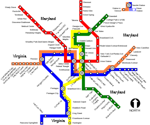
lines that constitute the Washington Metro
Washington Metro
The Washington Metro, commonly called Metro, and unofficially Metrorail, is the rapid transit system in Washington, D.C., United States, and its surrounding suburbs. It is administered by the Washington Metropolitan Area Transit Authority , which also operates Metrobus service under the Metro name...
rapid transit system in the Washington, D.C.
Washington, D.C.
Washington, D.C., formally the District of Columbia and commonly referred to as Washington, "the District", or simply D.C., is the capital of the United States. On July 16, 1790, the United States Congress approved the creation of a permanent national capital as permitted by the U.S. Constitution....
, metropolitan area. The Green Line consists of 21 stations
Metro station
A metro station or subway station is a railway station for a rapid transit system, often known by names such as "metro", "underground" and "subway". It is often underground or elevated. At crossings of metro lines, they are multi-level....
, with termini at Branch Avenue and at Greenbelt. The Green Line runs through Prince George's County
Prince George's County, Maryland
Prince George's County is a county located in the U.S. state of Maryland, immediately north, east, and south of Washington, DC. As of 2010, it has a population of 863,420 and is the wealthiest African-American majority county in the nation....
, Maryland
Maryland
Maryland is a U.S. state located in the Mid Atlantic region of the United States, bordering Virginia, West Virginia, and the District of Columbia to its south and west; Pennsylvania to its north; and Delaware to its east...
, and the District of Columbia. It was the last line in the original Metrorail plan to be constructed, and is one of three north–south lines through the city of Washington. It shares four stations with the Yellow Line
Yellow Line (Washington Metro)
The Yellow Line of the Washington Metro consists of 17 rapid transit stations from Huntington to Fort Totten. The line terminates at the Mount Vernon Square station during peak hours.Peak hours are 5 a.m. to 9:30 a.m. and 3 p.m. to 7 p.m. Service is extended to the Green Line stations during...
during rush hour service (nine stations during off-peak hours), one station with the Blue
Blue Line (Washington Metro)
The Blue Line of the Washington Metro in the United States consists of 27 rapid transit stations from Franconia–Springfield to Largo Town Center. It has stations in Fairfax County, Alexandria and Arlington, Virginia, the District of Columbia, and Prince George's County, Maryland...
and Orange
Orange Line (Washington Metro)
The Orange Line of the Washington Metro consists of 26 rapid transit stations from Vienna to New Carrollton. It has stations in Fairfax County and Arlington, Virginia, the District of Columbia, and Prince George's County, Maryland. Half of the line's stations are shared with the Blue Line, and over...
lines, and two stations with the Red Line
Red Line (Washington Metro)
The Red Line of the Washington Metro is a rail rapid transit service operating between 27 stations in Montgomery County, Maryland and the District of Columbia, United States. It is a primary line through downtown Washington, and the oldest and busiest line in the system...
.
The Green Line requires 19 trains (10 eight-car trains and nine six-car trains, consisting of 134 rail cars) to run at peak capacity.
History of the Green Line
Planning for Metro began with the Mass Transportation Survey in 1955 which attempted to forecast both freeway and mass transit systems sufficient to meet the needs of the region projected for 1980. In 1959, the study's final report included two rapid transit lines which anticipated subways in downtown Washington. Because the plan called for extensive freeway construction within the District of Columbia, alarmed residents lobbied for legislation which both created a new transportation agency and blocked freeway construction. The new agency, the National Capital Transportation Administration, issued a 1962 Transportation in the National Capital Region report, which did not include the route that became the Green Line. A central route under 7th Street in downtown was only added in 1967 primarily to serve the "inner city."In March 1968, the Washington Metropolitan Area Transit Authority
Washington Metropolitan Area Transit Authority
The Washington Metropolitan Area Transit Authority is a tri-jurisdictional government agency that operates transit service in the Washington, D.C. metropolitan area, including the Metrorail, Metrobus and MetroAccess...
(WMATA) board approved its 98 miles (157.7 km) Adopted Regional System (ARS) which included the Green Line from Branch Avenue to Greenbelt. It also foresaw possible future extensions to Laurel, Maryland
Laurel, Maryland
Laurel is a city in northern Prince George's County, Anne Arundel County, and Howard County, Maryland, United States, located midway between Washington, D.C. and Baltimore. Incorporated in 1870, the city maintains a historic district including its Main Street...
and Brandywine, Maryland
Brandywine, Maryland
Brandywine is an unincorporated area and census-designated place in Prince George's County, Maryland, United States, although the postal delivery area includes part of Charles County as well near Malcolm....
.
Early decision-making regarding the Green Line
Plans for rapid transit prior to the creation of WMATA in February 1967 focused on the needs of commuters while neglecting some of the District's less affluent neighborhoods. However, by late 1966, some plans started to include a line along 7th Street in the District of Columbia. The new line was included in WMATA's master plan for its proposed then-101-mile system in 1968. At that time, a Green Line was planned to pass through some of the area's poorest and most transit-dependent neighborhoods and provide them with subway service. Riots following the death of Martin Luther King in 1968 destroyed much of the commercial district around 14th and U Streets and planners hoped that adding a subway stop in that area would stimulate redevelopment. The original 1969 plan called for a line under 13th Street NW with just two stations. However, in 1970, the District of Columbia Council agreed to pay an additional $3 million to add a third station and reroute the Green Line under U Street, and then 14th Street NW. Instead of opening in 1976, the first Green Line stations opened in 1991. The southern part of the Green Line was originally to pass over the 11th Street Bridges11th Street Bridges
The 11th Street Bridges are a pair of one-way bridges across the Anacostia River in Washington, D.C., U.S.A. The southbound structure is officially named the Officer Kevin J. Welsh Memorial Bridge, while the northbound structure is officially named the 11th Street Bridge. The bridges convey...
to the intersection of Good Hope Road SE and Martin Luther King, Jr. Avenue SE, follow Martin Luther King, Jr. Avenue SE to Suitland Parkway
Suitland Parkway
The Suitland Parkway is a parkway in Washington, D.C., and Prince George's County, Maryland, maintained by the U.S. National Park Service. Conceived in 1937, it was built during World War II to provide a road connection between military facilities in the Washington, D.C., metropolitan area, and...
, down Suitland Parkway to Branch Avenue SE, and down Branch Avenue to a terminus at the intersection of Branch Avenue and the Capital Beltway
Interstate 495 (Capital Beltway)
Interstate 495 is a Interstate Highway that surrounds the United States' capital of Washington, D.C., and its inner suburbs in adjacent Maryland and Virginia. I-495 is widely known as the Capital Beltway or simply the Beltway, especially when the context of Washington, D.C., is clear...
. Public hearings on whether to build a Green Line and the route it should take were completed in 1973, and portions of the Green Line was originally scheduled to open in 1976.
The tunnel from the Gallery Place station to the Waterfront station—including the junction with the future Yellow Line
Yellow Line (Washington Metro)
The Yellow Line of the Washington Metro consists of 17 rapid transit stations from Huntington to Fort Totten. The line terminates at the Mount Vernon Square station during peak hours.Peak hours are 5 a.m. to 9:30 a.m. and 3 p.m. to 7 p.m. Service is extended to the Green Line stations during...
—was built at the same time as the other Metro tunnels in downtown Washington in the early 1970s. While a cut-and-fill tunnel for the Green Line was built under 7th Street and U Street, both street traffic and pedestrian access on those streets were difficult. The result was the loss of the traditional retail businesses along the route. The downtown segment of the line was originally projected to open in September 1977. Obtaining approval of the District of Columbia and Prince Georges' County of the exact alignment of the Green Line north of U Street delayed construction. Originally, the ARS called for the line to be placed in the median strip of the planned North Central Freeway, but after that road was cancelled, the route of the replacement subway tunnel became controversial, resulting in years of expensive delays.
Controversy dogged the route of the rest of the Green Line, however. The site of the Anacostia Station, set for the intersection of Martin Luther King Jr. Avenue SE and Good Hope Road SE, led to concerns that the station would destroy historic Old Anacostia, and after pressure from the federal government Metro moved the site of the station to Howard Road SE. By the end of 1977, Metro had pushed the opening of the Green Line to June 1983. Increasing construction costs and financing problems (caused primarily by the inability of local governments to contribute their share of Metro's funding) led WMATA to consider whether to shift the Green Line to a more southerly route along Wheeler Road SE to terminate near Rosecroft Raceway
Rosecroft Raceway
Rosecroft Raceway is a harness horse racing track located in Oxon Hill, Maryland, in the United States.-History:William E. Miller, a noted harness racer and horse breeder in the mid-20th century founded Rosecroft Raceway in 1947. It was the only known raceway to be owned by horse owners, horse...
. Another alternative would have built two Green Lines: One would follow Wheeler Road SE with a terminus at Southern Avenue
Southern Avenue (Washington, D.C.)
Southern Avenue is one of three boundary streets between Washington, D.C., and the state of Maryland. Following a southeast-to-northeast line, Southern Avenue begins at the intersection of South Capitol Street, Southeast and Indian Head Highway on the Maryland side. It runs for approximately seven...
; the other would follow Suitland Parkway to Martin Luther King, Jr. Avenue SE, then proceed northerly along Martin Luther King, Jr. Avenue SE to Good Hope Road SE and terminate at Good Hope Road SE and Minnesota Avenue SE (then called "Anacostia Station").
In October 1977, WMATA's Board of Directors refused to declare construction of the Green Line a "high priority" (favoring extension of the Red Line
Red Line (Washington Metro)
The Red Line of the Washington Metro is a rail rapid transit service operating between 27 stations in Montgomery County, Maryland and the District of Columbia, United States. It is a primary line through downtown Washington, and the oldest and busiest line in the system...
to Glenmont) but did instruct Metro staff to work on plans to fund the line and determine its route. Although the United States Department of Transportation
United States Department of Transportation
The United States Department of Transportation is a federal Cabinet department of the United States government concerned with transportation. It was established by an act of Congress on October 15, 1966, and began operation on April 1, 1967...
approved the Glenmont extension, federal officials were unhappy that Metro had yet to construct the Green Line into Anacostia.
In January 1978, a WMATA regional task force approved a Green Line route in Anacostia that followed Martin Luther King, Jr. Avenue and then Wheeler Road down to the Beltway (with a new station added near St. Elizabeths Hospital
St. Elizabeths Hospital
St. Elizabeths Hospital is a psychiatric hospital operated by the District of Columbia Department of Mental Health. It was the first large-scale, federally-run psychiatric hospital in the United States. Housing several thousand patients at its peak, St. Elizabeths had a fully functioning...
). Nonetheless, the Prince George's County government demanded in May 1978 that WMATA chose the Suitland-Parkway-to-Rosecroft route instead, and WMATA agreed to the change. In August 1978, WMATA's Board of Directors recommended to the federal government and its partner state and local governments that the entire 100 miles (160.9 km)-long (160.9 kilometres) Metrorail system be fully built—a proposal that included immediate construction of the Archives, Waterfront, Navy Yard – Ballpark, and Anacostia stations. WMATA announced in November 1978 that it had secured funding to build the Green Line from Gallery Place to Waterfront and that construction was nearly complete on this portion of the line, but that funding did not exist to push the line from Waterfront to Anacostia. Nonetheless, Metro reiterated that it intended to complete the extension to Anacostia Station by late 1983.
Two additional realignments occurred at the north end of the Green Line, but with less acrimony. North of Fort Totten, the line was to have surfaced in the median of the planned North Central Freeway, I-95
Interstate 95 in Maryland
Interstate 95 in Maryland is a major highway that runs diagonally from northeast to southwest, from Maryland's border with Delaware, to the Woodrow Wilson Bridge, briefly entering the District of Columbia before reaching Virginia...
, and proceeded to a point just west of Prince George's Plaza, with an intermediate station at Chillum
Chillum, Maryland
Chillum is an unincorporated area and census-designated place in Prince George's County, Maryland, United States. The population was 34,252 at the 2000 census...
. I-95 and Metro would have run through the Northwest Branch
Anacostia River
The Anacostia River is a river in the Mid Atlantic region of the United States. It flows from Prince George's County in Maryland into Washington, D.C., where it joins with the Washington Channel to empty into the Potomac River at Buzzard Point. It is approximately long...
Stream Valley Park; the cancellation of I-95 through the District and out to the Beltway
Interstate 495 (Capital Beltway)
Interstate 495 is a Interstate Highway that surrounds the United States' capital of Washington, D.C., and its inner suburbs in adjacent Maryland and Virginia. I-495 is widely known as the Capital Beltway or simply the Beltway, especially when the context of Washington, D.C., is clear...
in 1974 meant that it was no longer necessary or appropriate to condemn an I-95-sized swath of parkland just for Metro (as well as a Metro station and its parking lot). WMATA eventually selected a new route that skirted most of the park, and it was federally approved by the mid-1980s. The planned Chillum station was relocated and named West Hyattsville. The other alignment dispute occurred in the Petworth
Petworth, Washington, D.C.
Petworth is a residential neighborhood in the Northwest quadrant of Washington, D.C., bounded by Georgia Avenue to the west, North Capitol Street to the east, Rock Creek Church Road to the south, and Kennedy Street NW to the north...
section of Washington, and involved whether the tunnel would go under or skirt Rock Creek Cemetery
Rock Creek Cemetery
Rock Creek Cemetery — also Rock Creek Church Yard and Cemetery — is an cemetery with a natural rolling landscape located at Rock Creek Church Road, NW, and Webster Street, NW, off Hawaii Avenue, NE in Washington, D.C.'s Michigan Park neighborhood, near Washington's Petworth neighborhood...
and how to go through this soft-soil
Soil
Soil is a natural body consisting of layers of mineral constituents of variable thicknesses, which differ from the parent materials in their morphological, physical, chemical, and mineralogical characteristics...
burial ground (it was skirted using the New Austrian Tunnelling method
New Austrian Tunnelling method
The New Austrian Tunnelling method was developed between 1957 and 1965 in Austria. It was given its name in Salzburg in 1962 to distinguish it from old Austrian tunnelling approach. The main contributors to the development of NATM were Ladislaus von Rabcewicz, Leopold Müller and Franz Pacher...
), and the least disruptive way under New Hampshire Avenue from Georgia Avenue – Petworth to Columbia Heights (the tunnels were stacked).
Legal and funding battles
In December 1978, Metro announced that the new completion date of the Green Line past the Anacostia Station to Rosecroft Raceway would be 1987 (a year later than anticipated). Metro also announced that cost considerations had forced it to abandoned the high-vault ceiling design for all unbuilt stations (except Navy Yard), and that a less-costly design would be used at all unbuilt Green Line stations. By July 1979, despite the release of billions of dollars in construction funds by the U.S. Department of Transportation, Metro had pushed back the construction of the Anacostia Station to mid-1985 and the completion of the Branch Avenue Line to late 1986. But construction schedules continued to slip. Despite reaffirming its construction schedules in December 1979, Metro announced in January 1980 that completion of the Green Line terminus in Prince George's County would be pushed back six more months to 1987.Even as Metro officially designated Rosecroft Raceway as the Green Line's southern terminus, more than half of Prince George's County's representatives in the Maryland state legislature asked Governor
Governor of Maryland
The Governor of Maryland heads the executive branch of the government of Maryland, and he is the commander-in-chief of the state's National Guard units. The Governor is the highest-ranking official in the state, and he has a broad range of appointive powers in both the State and local governments,...
Harry Hughes
Harry Hughes
Harry Roe Hughes , a member of the United States Democratic Party, was the 57th Governor of Maryland in the United States from 1979 to 1987.-Early life and family:...
to review the proposed route after allegations of improper political pressure regarding the 1978 route decision surfaced. Metro officials proceeded anyway in March 1984 with Green Line design and planning, and moved the line's completion date up to late 1986.
Funding troubles delayed construction even further. In March 1980, Maryland officials worried that high inflation would leave Metro without enough funds to complete the Green Line, forcing Maryland to pay these construction costs alone. These fears were confirmed in part in September 1980 when Metro announced that inflation had created a $16 million shortfall in its $271 million budget. By now, Anacostia residents were increasingly angry at the repeated delays in building the Green Line. In September 1980, D.C. City Council member Jerry A. Moore, Jr. delivered a petition containing 1,000 signatures from Anacostia residents demanding that construction on the Green Line be sped up.
In October 1980, The Washington Post
The Washington Post
The Washington Post is Washington, D.C.'s largest newspaper and its oldest still-existing paper, founded in 1877. Located in the capital of the United States, The Post has a particular emphasis on national politics. D.C., Maryland, and Virginia editions are printed for daily circulation...
ran a major article asking "What Ever Happened to the Green Line?" in which the newspaper concluded: "The 18.86-mile Green Line, which some argue should have been the first built because it would serve the most disadvantaged sections of the Washington area, is last on the construction list and threatened with extinction." The article confirmed that funds were in place and contracts signed to complete the Green Line to the proposed Anacostia Station at Howard Road SE and Martin Luther King, Jr. Avenue SE, but that repeated local opposition in Maryland to the line's actual location had forced planners to delay final siting of the line inside the District of Columbia. Additionally, Maryland businessmen argued that the switch of the terminus from Branch Avenue to Rosecroft Raceway had economically harmed them, and they filed a suit in the United States District Court for the District of Maryland
United States District Court for the District of Maryland
The United States District Court for the District of Maryland is the Federal district court whose jurisdiction is the state of Maryland....
demanding a halt to construction of the Green Line until the line's route could be again reconsidered.
The District of Columbia government responded by threatening to veto any further Metro subway construction unless construction of the Green Line was made Metro's highest priority. Twenty-four hours of intense discussions later, Metro agreed to the District government's wishes. Construction began on the Waterfront Station, and the station was largely complete by January 1981. Once complete, the station was used for storage. By December 1980, Metro was still predicting that the Green Line to Anacostia would open in July 1986. But in January 1981, Metro admitted that the line would not open until at least 1990 because of funding constraints. Two months later, Metro estimated the cost of building the Green Line from U Street NW to Anacostia at $175 million.
Controversies regarding the siting of the Green Line continued. In May 1980, a group of business owners near the former proposed terminus at Branch Avenue and Auth Road near Marlow Heights
Marlow Heights, Maryland
Marlow Heights is an unincorporated area and census-designated place in Prince George's County, Maryland, United States. The population was 6,059 at the 2000 census...
sued Metro on the grounds that the decision to change the course of the Green Line was illegal because it had been undertaken without a public hearing (in violation of Metro's rules). In February 1981, Judge Norman Park Ramsey
Norman Park Ramsey
Norman Park Ramsey was a United States federal judge.Born in Fairchance, Pennsylvania, Ramsey was a U.S. Marine Corps First Lieutenant from 1943 to 1946. He received an LL.B. from the University of Maryland School of Law in 1947. He was a law clerk, Hon. W.C. Chesnut, U.S. District Court, District...
of the U.S. District for Maryland
United States District Court for the District of Maryland
The United States District Court for the District of Maryland is the Federal district court whose jurisdiction is the state of Maryland....
held that Metro did not correctly advertise the hearings at which the change would be discussed. Metro appealed the ruling, and Judge Ramsey did not enjoin
Injunction
An injunction is an equitable remedy in the form of a court order that requires a party to do or refrain from doing certain acts. A party that fails to comply with an injunction faces criminal or civil penalties and may have to pay damages or accept sanctions...
Metro from proceeding with construction until the appeal was resolved. The Prince George's County government, however, reaffirmed in April 1981 its support for the Rosecroft Raceway terminus, and Metro promised to hold a public hearing on the issue in June 1981. Shortly thereafter, the civil rights office in the U.S. Department of Transportation sent a letter to Metro warning that the Rosecroft Raceway route could negatively impact two historically black communities nearby. In May 1981, Metro changed its estimate for the opening of the Green Line to Anacostia to early 1988.
Prince George's County officials continued to worry that cutbacks in federal funding for mass transit might lead to the cancellation of the four proposed stations (Southern Avenue, Naylor Road, Suitland, and Branch Avenue) in the county. Prince George's officials vetoed in July 1981 any further expenditure of Metro's construction funds unless Metro diverted $100 million from the Red Line
Red Line (Washington Metro)
The Red Line of the Washington Metro is a rail rapid transit service operating between 27 stations in Montgomery County, Maryland and the District of Columbia, United States. It is a primary line through downtown Washington, and the oldest and busiest line in the system...
extension in Montgomery County
Montgomery County, Maryland
Montgomery County is a county in the U.S. state of Maryland, situated just to the north of Washington, D.C., and southwest of the city of Baltimore. It is one of the most affluent counties in the United States, and has the highest percentage of residents over 25 years of age who hold post-graduate...
to Glenmont and began the immediate purchase of land and rights-of-way in Prince George's County. Metro agreed a month later to the plan, with the proviso that $90 million per year would be spent to begin work on the inner-city portion of the Green Line (the Gallery Place, Waterfront, and Navy Yard stations).
Metro held its long-awaited hearings over the Green Line's route in October 1981, but only in Prince George's County (not the District). A month later, the 4th Circuit Court of Appeals
United States Court of Appeals for the Fourth Circuit
The United States Court of Appeals for the Fourth Circuit is a federal court located in Richmond, Virginia, with appellate jurisdiction over the district courts in the following districts:*District of Maryland*Eastern District of North Carolina...
turned down Metro's appeal. Metro subsequently estimated on December 9, 1981, that the Green Line would reach Anacostia in late 1989.
Funding problems delayed construction even further. In February 1982, President
President of the United States
The President of the United States of America is the head of state and head of government of the United States. The president leads the executive branch of the federal government and is the commander-in-chief of the United States Armed Forces....
Ronald Reagan
Ronald Reagan
Ronald Wilson Reagan was the 40th President of the United States , the 33rd Governor of California and, prior to that, a radio, film and television actor....
proposed cutting Metro construction funds by 21.4 percent to just $295 million a year. Planned Green Line construction constituted 40.5 percent of Metro's construction budget, and the cuts threatened to cancel the entire Green Line. To African American community leaders, the cuts were evidence that Metrorail was meant for suburban white commuters while inner city African Americans were relegated to taking Metrobus. Despite the funding troubles, Metro planned to seek contractors in March 1982 for a $60 million contract to tunnel under the Anacostia River, a $60 million contract to build the Anacostia Station, and a $100 million contract to build the Navy Yard Station. But on March 16, 1982, Judge Ramsey barred Metro from spending any money on the construction of the Rosecroft Raceway route for the southern half of the Green Line. Judge Ramsey held that Metro had decided to shift the Green Line route without properly advertising the public hearings, which the transit system would now be required to hold (delaying construction of the Green Line and Anacostia Station by at least a year). Although Metro had advertised the hearings, Judge Ramsey said, the advertisements contained the same wording flaws that had precipitated the Maryland lawsuit. Metro subsequently scheduled new hearings for June 1982.
Metro officials considered shifting construction funds from the southern Green Line to the northern Green Line in order to start construction on that end of the line, but the D.C. City Council opposed this shift. Metro held the court-ordered hearings in June 1982, at which Prince George's residents argued that they had voted for Metro's 1968 bond issue based on the original Green Line route. Metro promised attendees at the hearing that agency staff would study the Green Line route and issue a report recommending a route, after which construction on the Anacostia River tunnel would begin. The site of the tunnel thus became an issue, with some residents arguing for a tunnel from the Navy Yard under Anacostia Park to Martin Luther King, Jr. Avenue SE, while others wanted the tunnel to take a more northerly route alongside the 11th Street Bridges to Good Hope Road SE. In October 1982, Metro estimated that opening of the Green Line to Anacostia would happen in the "late 1980s", and in November a Metro staff report recommended construction of the Rosecroft Raceway route.
Cuts in federal construction funds for Metro again delayed construction. Metro announced in December 1982 that service on the line would not cross the Anacostia River until late 1989 at the earliest. The federal contribution to Metro's construction fund was lowered to $44 million from $95 million for fiscal 1983, and Metro said that it would divert most of that money to dig tunnels from the Gallery Place Station to the Mount Vernon Square station. In February 1983, the Reagan administration proposed cutting Metro's construction budget by $145 million to $230 million, which Metro said would push the opening of the Green Line to 1991. Metro, for the first time in its history, formally announced that (absent full construction funding) it could not build the Green Line, the Red Line from Wheaton to Glenmont, or the Yellow Line from Franconia-Springfield to King Street – Old Town.
As Metro struggled to secure construction funding for the Green Line and Anacostia Station, it also struggled to lift the district court's injunction on Green Line construction. Metro asked the court to allow construction of the Navy Yard, Anacostia, and Congress Heights stations pending a decision on the Green Line route in Prince George's County, but the court refused. Judge Ramsey said that Metro's public hearing process was biased and "inadequate". Even as the court refused to let Green Line construction in Anacostia begin, more than 23,000 Anacostia residents signed a public petition demanding that the line be built. Metro declined to appeal Judge Ramsey's latest ruling, and the Prince George's County Council voted to reverse its earlier decision and support the original Green Line route to Branch Avenue.
Frustrated by funding constraints and the court injunction, in December 1983 Metro released a proposed "final" system map that showed the Green Line terminating at the Anacostia and Mount Vernon Square stations.
Resolution of controversies
In 1984, Metro undertook two steps to secure completion of the Green Line. First, the transit agency hired former U.S. Secretary of Transportation William T. Coleman, Jr.William Thaddeus Coleman, Jr.
William Thaddeus Coleman, Jr. was the fourth United States Secretary of Transportation, from March 7, 1975 to January 20, 1977, and the second African American to serve in the Cabinet...
in December 1983 to oversee negotiations with the various entities involved with the siting of the Green Line route and seek a resolution through the U.S. district court. On February 21, 1984, Prince George's County Executive Parris Glendening
Parris Glendening
Parris Nelson Glendening , a member of the United States Democratic Party, was the 59th Governor of Maryland from January 18, 1995 to January 15, 2003...
announced that construction of the Green Line in Prince George's must start by September 30, 1984, or he would begin vetoing Metro spending proposals. At the same time, Metro and Coleman opened negotiations to build the Green Line from the L'Enfant Plaza Station to Anacostia. Advocates of the Rosecroft route, however, warned that they would sue if Metro switched back to the original route.
Just four days later, Metro, D.C. and Prince George's County officials, and advocates of both the Branch Avenue and Rosecroft routes reached an agreement to begin construction of the Green Line fron L'Enfant Plaza to Anacostia, pending resolution of the line's final route by December 6, 1984. The agreement called for construction of the Green Line to Waterfront Station in the summer, siting of the tunnel under the Anacostia River by June 28, and the holding of public hearings on the remaining route between July 18 and August 3. The U.S. federal district court approved the agreement on March 7. Following the ruling, Metro announced that it would build the Anacostia Station on Howard Road between Martin Luther King, Jr. Avenue SE and the Anacostia Freeway, as well as a new Metro station at the Washington Navy Yard, and would open the Green Line by 1990. Metro asked and won approval from the court to build the Navy Yard and Anacostia stations and the tunnel in June 1984.
Metro also began new political efforts to secure funding to complete the transit system. Initially, Reagan administration officials balked at this plan, reiterating that they would not permit Metro to build more than 76.4 miles (120 km) of subway. But in June, House and Senate committees passed legislation requiring the Reagan administration to release all funds appropriated for Metro, putting pressure on the administration to rescind its 76.4 miles (123 km) limit.
Constructing the Green Line
Construction of the Green Line south from L'Enfant Plaza began in July 1984 when WMATA issued a call for bids to tunnel under the Anacostia River. The firm of Harrison Western/Franki-Denys (a joint venture) was awarded the $25.6 million contract, with construction to begin in December 1984. WMATA delayed awarding the contract after American anti-apartheid activists alleged that a BelgianBelgium
Belgium , officially the Kingdom of Belgium, is a federal state in Western Europe. It is a founding member of the European Union and hosts the EU's headquarters, and those of several other major international organisations such as NATO.Belgium is also a member of, or affiliated to, many...
company with a minority financial interest in Franki-Denys did business with the racist white-led government of South Africa
South Africa
The Republic of South Africa is a country in southern Africa. Located at the southern tip of Africa, it is divided into nine provinces, with of coastline on the Atlantic and Indian oceans...
, but after the links were discovered to be extremely minor the contract was awarded.
The debate over the route for the remainder of the Green Line was finally resolved in December 1984. Residents and D.C. government officials asked WMATA to build stations at Congress Heights and Southern Avenue
Southern Avenue (Washington, D.C.)
Southern Avenue is one of three boundary streets between Washington, D.C., and the state of Maryland. Following a southeast-to-northeast line, Southern Avenue begins at the intersection of South Capitol Street, Southeast and Indian Head Highway on the Maryland side. It runs for approximately seven...
in order to promote economic development and provide service to St. Elizabeths Hospital
St. Elizabeths Hospital
St. Elizabeths Hospital is a psychiatric hospital operated by the District of Columbia Department of Mental Health. It was the first large-scale, federally-run psychiatric hospital in the United States. Housing several thousand patients at its peak, St. Elizabeths had a fully functioning...
and Greater Southeast Community Hospital. In December 1984, WMATA's Board of Directors agreed to return the Green Line to its original route, and build the Congress Heights and Southern Avenue stations. The U.S. district court approved WMATA's decision and dissolved its March 1982 injunction, which had barred construction of the $483 million southern Green Line (now estimated to cost $132 million more than the Rosecroft route).
Funding for Green Line construction fell into place in 1985. Pressured by the previous year's Congressional action, the Reagan administration sought to provide WMATA with $250 million a year for four years to expand the system to 89.5 miles (144 km), a plan which would not fund construction of the system beyond the proposed Southern Avenue Station.
Construction on the line started in 1985. Survey
Surveying
See Also: Public Land Survey SystemSurveying or land surveying is the technique, profession, and science of accurately determining the terrestrial or three-dimensional position of points and the distances and angles between them...
and clearing work for the twin 2,500-foot (762 m) Anacostia River tunnels began in March 1985. A 24 foot (7.32 m) long, 19 foot (5.8 m) diameter tunnel boring machine
Tunnel boring machine
A tunnel boring machine also known as a "mole", is a machine used to excavate tunnels with a circular cross section through a variety of soil and rock strata. They can bore through anything from hard rock to sand. Tunnel diameters can range from a metre to almost 16 metres to date...
built by the Hitachi Zosen Corporation was shipped to the U.S. to drill the tunnel, which required boring techniques "so novel that they have never before been used in the eastern United States." The tunnel boring machine ate through "T5" (relatively fine sand mixed with gravel and boulders which occasionally required workers to physically break the boulders apart) and clay formations about 50 feet (15.2 m) beneath the riverbed. The walls of the tunnel were lined with concrete as the machine moved. Liquid nitrogen
Liquid nitrogen
Liquid nitrogen is nitrogen in a liquid state at a very low temperature. It is produced industrially by fractional distillation of liquid air. Liquid nitrogen is a colourless clear liquid with density of 0.807 g/mL at its boiling point and a dielectric constant of 1.4...
was used to harden the ground where the inbound tunnel reached the northern side of the Anacostia River, to lessen the possibility of cave-ins due to the wet earth.
The completion date for the two tunnels was estimated at late 1987. WMATA engineers also inspected the mothball
Mothball
Mothballs are small balls of chemical pesticide and deodorant used when storing clothing and other articles susceptible to damage from mold or moth larvae ....
ed Waterfront Station and found it to be still structurally sound (although water needed to be pumped from the station). However, some repairs to the tunnel between L'Enfant Plaza and Waterfront needed to be made. Construction of the tunnel from Waterfront to Navy Yard was set to begin in September 1985, construction of the Navy Yard station in early 1986, and linkage with the Anacostia River tunnels shortly thereafter. The two new Green Line stations were expected to open in 1990. In October 1985, WMATA awarded the $24.9 million contract to excavate the tunnel between the Waterfront and Navy Yard stations to Harrison Western Corp. WMATA's board awarded a $41.5 million contract for the construction of the Anacostia Station to Kiewit Construction Co. in June 1985, and said the station would open in 1990. Ground was broken at the site on September 21, 1985.
Funding for construction of the Green Line was threatened again in 1986. WMATA needed $2 billion in construction funds, but Congress was threatening to cut WMATA's funding by up to 26 percent to $184.5 million a year for four years. Congress approved $227 million for 1986 in December 1985, but the Reagan administration said that it would cut off all funding thereafter. WMATA appealed directly to President Reagan to release $400 million in funds already appropriated, but administration officials said WMATA had more than enough money to complete the Green Line. Prince George's County officials threatened to sue Metro as well as block all further construction spending in March 1985 unless WMATA agreed to use its existing funds to build the Green Line into their county. WMATA officials reacted in June by stretching out construction of the Green Line and Anacostia station to 1991. After lengthy negotiations (which included state and local guarantees to pay for cost overruns or funding shortfalls, penalties for defaults, and the imposition of two external financial monitors) and heavy pressure from Congress, Reagan administration officials released the $400 million on July 16, 1986.
With the funds released, construction on the Green Line proceeded quickly. In November 1986, WMATA awarded a $36.2 million contract to Mergentime Corp. to build the Navy Yard Station. A month later, WMATA awarded a $19.5 million contract to excavate a tunnel from the Navy Yard Station to the tunnels being built under the Anacostia River. On March 23, 1986, the second of the two 2,450-foot (747.25 metre), concrete-lined tunnels under the Anacostia River was completed. With the tunnels finished and other contracts awarded, WMATA announced yet another revised timeline for opening the Green Line in April 1987. The transit agency estimated that the Mount Vernon Square, Shaw, and U Street stations would open in late 1990, the Mount Vernon Square to Anacostia link in late 1991, and the Fort Totten to Greenbelt link by 1994. In January 1988, WMATA awarded a $179.1 million contract to build the Green Line from Fort Totten to Greenbelt, and a $6.9 million contract to complete the Waterfront station. In December 1988, WMATA reaffirmed that the Waterfront, Navy Yard, and Anacostia stations would open in late 1991.
Beginning in 1989, WMATA sought funding to extend the Green Line beyond the Anacostia Station and to operate the Green Line. Metro asked Congress to authorize $2.16 billion over 10 years to complete the 103 miles (165.8 km) system, as well as appropriate the remaining $193 million from the transit agency's original 1980 authorization to complete the Green Line from Anacostia to Branch Avenue and link the Green Line internally between U Street and Fort Totten. Although the Bush administration
George H. W. Bush
George Herbert Walker Bush is an American politician who served as the 41st President of the United States . He had previously served as the 43rd Vice President of the United States , a congressman, an ambassador, and Director of Central Intelligence.Bush was born in Milton, Massachusetts, to...
opposed the request, Congress provided $2.025 billion. Only the stations at Suitland and Branch Avenue remained unfunded.
By mid-1991, however, falling inflation had reduced WMATA's construction costs so much that the agency said it could build the two final Green Line stations in Prince George's County without asking Congress for additional money. WMATA also proposed spending money almost three times faster up-front to accelerate its construction schedule, a move which would be more than compensated for by savings in out-years. Prince George's County officials threatened to block all further Metrorail construction unless they received guarantees that the stations in their county would be built. Funding for the remaining seven Green Line stations in the District and Prince George's remained in doubt as of August 1991, with District officials saying that it made sense to build the Georgia Avenue – Petworth and Columbia Heights stations and Prince George's representatives demanding that the three stations in their county be completed. WMATA said that it had so little money it could not fund 16 critical small construction projects, among them security gates at the Navy Yard and Waterfront stations and parts for escalators at the seven new Green Line stations in D.C. and Prince George's County. The funding impasse was broken in November 1991 when local and state governments agreed to roughly triple their contribution to Metro's construction costs by 1994 to complete the entire system.
The first WMATA budget which contained funds for operating the Green Line was proposed in December 1989. The budget presumed a December 1, 1990, opening for the Mt. Vernon Square, Shaw–Howard University and U Street–Cardozo stations, and requested funds to test the soon-to-open Green Line from Gallery Place–Chinatown to the Anacostia Station. The budget also projected that the Green Line from Gallery Place–Chinatown to the Anacostia Station would open in 1991, and that new Metrobus service will be added in Prince George's County to bring commuters to the new station.
The opening of the Green Line was significantly delayed, however, when in May 1990 WMATA fired the contractor building the Shaw–Howard University and U Street–Cardozo stations. Mergentime/Perini Joint Venture, the contractor working on the stations, had violated its contract with WMATA by reducing the workforce on the project, not meeting project deadlines, and permitting unsafe working conditions to persist. Mergentime/Perini denied the accusations. Although similar problems plagued Mergentime/Perini's work on the Navy Yard station, WMATA did not fire the joint venture company from that project. WMATA said that the problems would delay the Green Line's opening until at least the late spring of 1991.
In August 1990, WMATA hired the Perini Corp. as the new contractor, and required the company to finish the job and rebuild the streets in the area, setting a new Green Line dedication of December 1991. Federal monitors overseeing WMATA's spending, however, issued a report in August 1990 accusing WMATA of poor financial oversight of the project and blamed the transit agency for the delays and problems Mergentime/Perini confronted. Mergentime/Perini sued WMATA, claiming that it was improperly dismissed from the project.
The cost of testing and operating the Green Line left WMATA struggling financially. These costs (along with costs associated with extending and operating the Blue Line
Blue Line (Washington Metro)
The Blue Line of the Washington Metro in the United States consists of 27 rapid transit stations from Franconia–Springfield to Largo Town Center. It has stations in Fairfax County, Alexandria and Arlington, Virginia, the District of Columbia, and Prince George's County, Maryland...
to Van Dorn Street
Van Dorn Street (WMATA station)
Van Dorn Street is an island platformed Washington Metro station in both Fairfax County and Alexandria, Virginia, United States. The station was opened on June 15, 1991, and is operated by the Washington Metropolitan Area Transit Authority . Providing service for the Blue Line, the station is...
) forced WMATA to cut 335 jobs as well as supplies, travel, overtime, and temporary employee budgets. Although ridership was projected to rise 3.8 percent to 260 million trips in the coming year, the increased revenue was not expected to cover the costs of operating the new lines and stations. Mount Vernon Square, Shaw–Howard University, and U Street–Cardozo stations opened on Saturday, May 11, 1991.
Construction of the Green Line past Anacostia Station was complicated by the discovery of a potential toxic waste site in the path of the subway. In June 1991, WMATA discovered that the District of Columbia had dumped 426,000 tons of possibly hazardous incinerator bottom ash
Incinerator bottom ash
Incinerator bottom ash is a form of ash produced in incineration facilities. This material is discharged from the moving grate of municipal solid waste incinerators. Following combustion the ash typically has a small amount of ferrous metals contained within it. This ash can be processed to...
in an unused exposed culvert
Culvert
A culvert is a device used to channel water. It may be used to allow water to pass underneath a road, railway, or embankment. Culverts can be made of many different materials; steel, polyvinyl chloride and concrete are the most common...
along the subway's potential path near St. Elizabeth's Hospital between 1977 and 1989. The city continued to dump the ash at the site for four years after it learned that WMATA planned to use the site for the Green Line. Experts were concerned that the ash dump contained pockets of methane gas and soluble acid, which would make the site unusable by Metrorail.
Maryland officials used the discovery to press yet again for realignment of the Green Line and abandonment of the planned stations at Congress Heights and Southern Avenue in favor of construction of the stations at Naylor Road, Suitland, and Branch Avenue. The proposal led to public protests against the Maryland plan in Anacostia, and heated arguments on the WMATA board of directors. In an initial report in June 1991, WMATA determined that ash posed no environmental risk, although there were concerns that the level of pollutants would prevent any excavated material from being accepted by landfills in D.C., Maryland, or Virginia. A final environmental report in November 1991 found that the ash was not hazardous, but would need to be removed at a cost of $1 million.
The Green Line from L'Enfant Plaza to Anacostia opened as scheduled on December 28, 1991. Ridership expanded rapidly on the Green Line. In the first workweek of the year, more than 8,000 riders a day boarded at the three stations in Southeast D.C. (more than 5,000 of them at Anacostia), exceeding WMATA's estimates, and nearly 10,000 riders were boarding each day at the three stations by the third week of January.
Construction of the Green Line near Berwyn Heights, Maryland
Berwyn Heights, Maryland
Berwyn Heights is a town in Prince George's County, Maryland, United States. The population was 2,942 at the 2000 census. It is bordered by College Park to the west, Greenbelt to the northeast, East Riverdale to the southwest, and Riverdale Park to the south....
resulted in the creation of Lake Artemesia
Lake Artemesia
Lake Artemesia is a man-made lake in Prince George's County, Maryland, USA. It is part of the Lake Artemesia Natural Area in College Park and Berwyn Heights...
. In 1976, WMATA removed sand and gravel needed for construction from open space adjacent to the Green Line. In exchange, WMATA paid to develop the area as a lake surrounded by a park.
The Green Line stations at Greenbelt, College Park, Prince George's Plaza, and West Hyattsville opened in November 1993. Almost two years later, WMATA broke ground on the Suitland, Naylor Road, Southern Avenue, and Congress Heights stations, a $900 million project which would complete the final 6.5 miles (10.5 km) of the originally-planned 103-mile (165.7 km) Metrorail system in late 1999. The outbound tunnel to Congress Heights was completed in June 1998. The Georgia Avenue-Petworth and Columbia Heights stations were completed in September 1999, three months ahead of schedule. The Green Line's final five stations opened on January 13, 2001.
Bus controversy
Like all Metrorail stations, the Anacostia Station was intended to be a major hub for Metrobus service in its area. But with the Anacostia neighborhood being the poorest and most transit-dependent area in the District of Columbia, changes to bus routes in the area proved highly controversial. As the opening of the Green Line to Anacostia neared, WMATA proposed halving the number of bus routes traveling between Anacostia and the National Archives Building downtown—forcing riders to take the more expensive Metrorail and requiring many riders to walk several blocks to their destination (rather than the "virtually door-to-door service" they then enjoyed). A total of 25 routes were changed, affecting more than 80,000 riders.Many of the new routes terminated at the Anacostia Station rather than continue into downtown Washington, as they once had. WMATA officials admitted that fares for most Anacostia residents would rise an average of 50 percent, and that Anacostia residents would be forced to pay more and travel farther to access the services (such as doctors) and shopping that most District residents can readily access. To help mediate the impact of the total fare increase on Anacostia residents, WMATA reduced basic bus fares for many routes in the area from $1 to 35 cents.
District residents protested the route cuts with a picket line in front of WMATA's downtown headquarters in August 1991. Prince George's County residents were also angered by the bus route changes, arguing that Metro had promised more (not less) bus service and complaining that they would be forced to use a rail station located in the District of Columbia's most violent and crime-prone neighborhood. More than 1,000 people packed "raucous" public hearings for three nights in the District and Prince George's County in early September, denouncing Metro and claiming they were "becoming a victim of transportational apartheid." Worried about the impact of the cuts as well as a possible bus boycott, D.C. Mayor Sharon Pratt Dixon
Sharon Pratt Kelly
Sharon Pratt Kelly , formerly Sharon Pratt Dixon and now known as Sharon Pratt, was the third mayor of the District of Columbia from 1991 to 1995. Pratt was the first African-American woman to serve as mayor of a major American city...
announced on September 11, 1991, that she would seek an alternative to the changes proposed by WMATA. Suburban commuters were angry that Metro would keep the bus routes open in Anacostia (at an estimated cost of $4 million) when their bus service had been cut at the time Metrorail stations opened in their areas; D.C. residents countered that poor African American
African American
African Americans are citizens or residents of the United States who have at least partial ancestry from any of the native populations of Sub-Saharan Africa and are the direct descendants of enslaved Africans within the boundaries of the present United States...
District citizens could ill afford the same transit changes and fare increases that wealthy, white suburbanites were asked to absorb.
Calls for a boycott increased in mid-September. On September 16, 1991, declaring that the city paid "40 percent of the
Prince George's County, meanwhile, announced that its county-run buses ("The Bus") would not run to Anacostia Station as previously promised, drawing outrage from D.C.'s representatives on Metro's board. The District of Columbia had spent more than $20 million adding bus bays at the station to accommodate The Bus arrivals.
Two months after the Anacostia Station opened, WMATA said that a study of bus and rail ridership showed that the unaltered bus routes were costing the transit agency $200,000 a month in lost rail fares. To make up the lost revenue, WMATA said that it would run only two-car trains (the shortest on the system) on the Green Line during slow periods weekdays and evenings and on Sundays beginning in June 1992. In November 1992, WMATA reported that ridership at the Anacostia Station was (on average) 7,500 riders a day, 700 below estimates. WMATA admitted that although riders had made the switch from bus to rail, the lower ridership numbers were due to the recession
Early 2000s recession
The early 2000s recession was a decline in economic activity which occurred mainly in developed countries. The recession affected the European Union mostly during 2000 and 2001 and the United States mostly in 2002 and 2003. The UK, Canada and Australia avoided the recession for the most part, while...
and not because of continuing downtown bus service in the area. Metro said ridership on buses in the neighborhood was down significantly, and the transit agency reduced the number of buses on some routes to avoid having empty buses.
Rail car shortage
WMATA first became aware of a rail car shortage in 1988. Generally, rail cars were ready for service three to four years after WMATA signed a contract for their purchase. Metrorail also suffered from internal squabbling over rail car design, and rail car production had historically been plagued by poor quality and laborTrade union
A trade union, trades union or labor union is an organization of workers that have banded together to achieve common goals such as better working conditions. The trade union, through its leadership, bargains with the employer on behalf of union members and negotiates labour contracts with...
strikes
Strike action
Strike action, also called labour strike, on strike, greve , or simply strike, is a work stoppage caused by the mass refusal of employees to work. A strike usually takes place in response to employee grievances. Strikes became important during the industrial revolution, when mass labour became...
—both of which also added to construction delays. Although WMATA knew in 1988 that it needed at least 98 new rail cars to provide adequate service to the new stations to be added on the Green Line and other lines by 1993, WMATA did not place an order for the cars. By September 1990, WMATA was also confronting more frequent breakdowns in its existing, aging rail car fleet, which heightened the urgency to buy more cars. Officials estimated that the rail car shortage would become critical when the Anacostia Station opened. When the Van Dorn Street Station opened in June 1991, Metro was forced to run trains every 12 minutes during rush hour rather than every 8 due to the rail car shortage. Eventually, crowding was addressed when additional cars became available by running 8-car trains.
Metro also encountered significant problems estimating the number of riders who would board the system at the Anacostia and other Green Line stations. In June 1991, WMATA estimated that just over 15,000 riders on average would board at the Waterfront, Navy Yard, and Anacostia stations. In December 1991, when the Anacostia Station opened, Metro had revised that number to 30,700 riders per day (by June 1992). Just a week later, Metro dropped that estimate to only 28,000 riders a day (by June 1992).
Even though significant numbers of bus riders in Anacostia had switched to Metrorail by February 1992, WMATA nonetheless began running two- rather than four-car trains on the Green Line on Sundays and during slow periods in order to close a revenue shortfall.
Metro finally ordered new rail cars, but the first of the cars were not due to be delivered until February 2001.
The December 2000 opening of the final five Green Line stations (Branch Avenue, Suitland, Naylor Road, Southern Avenue, and Congress Heights) significantly worsened overcrowding and service problems on the Green Line. The five new stations added almost 20,000 new riders a day, overwhelming station platforms, jamming trains to capacity, and forcing many riders at Anacostia and other stations up the line to wait as train after train passed them filled. Metro had estimated that 18,000 riders a day would board from these stations by June 2001. That estimate was exceeded by 2,000 riders a day on the second day the stations were open.
By January 24, the number had risen to more than 30,600 per day—three times as many as originally estimated. Angry commuters using the Anacostia, Navy Yard, and Waterfront stations peppered the transit agency with complaints. WMATA claimed that a number of factors contributed to the ridership crunch: the system was experiencing record ridership; two-year-old ridership projections were used; the five stations were opened two months ahead of schedule; the five new stations were opened two months before new rail cars were ready for service; and WMATA offered free parking at the Green Line stations, which drew 12,000 rather than 4,000 riders to the line.
Service
Service on the Green Line tracks began on May 11, 1991 on three stations between U Street/African-American Civil War Memorial/Cardozo and Gallery Place–Chinatown. Initially, all trains through this section were run as Yellow LineYellow Line (Washington Metro)
The Yellow Line of the Washington Metro consists of 17 rapid transit stations from Huntington to Fort Totten. The line terminates at the Mount Vernon Square station during peak hours.Peak hours are 5 a.m. to 9:30 a.m. and 3 p.m. to 7 p.m. Service is extended to the Green Line stations during...
trains terminating at Huntington. The Green Line formally began on December 28, 1991, with three stations south of L'Enfant Plaza to Anacostia. At this time, Yellow Line service north of Mount Vernon Square was discontinued and those stations were served only by the new Green Line. The four-station branch north of Fort Totten to Greenbelt opened on December 11, 1993. The two segments were connected on September 18, 1999, with two stations opening, and the last five stations south to Branch Avenue opened on January 13, 2001, completing the original 101 miles (162.5 km) Metrorail system.
After the branch north of Fort Totten opened, the Green Line Commuter Shortcut began as a six-month experiment on January 27, 1997, allowing passengers to get on a train on the Green Line segment during rush hours and travel as far as Farragut North on the Red Line without having to switch trains at Fort Totten; a transfer was needed during off-peak hours. This was accomplished by utilizing a single-track spur (B & E connection) between the Green and Red Lines near (and bypassing) Fort Totten station. This shortcut was so well-received that it was continued until September 17, 1999, when the mid-city portion of the Green Line was completed.
In 2006, WMATA board member Jim Graham
Jim Graham
Jim Graham is a U.S. politician and a member of the Council of the District of Columbia. He is a Democrat representing Ward 1 - the most populated and diverse area in Washington, D.C....
and D.C. Mayor Anthony A. Williams
Anthony A. Williams
Anthony Allen "Tony" Williams is an American politician who served as the fifth mayor of the District of Columbia for two terms, from 1999 to 2007. He had previously served as chief financial officer for the District, managing to balance the budget and achieve a surplus within two years of...
proposed re-extending Yellow Line service to Fort Totten or even to Greenbelt, which was the originally planned northern terminus for the line. Their proposal did not involve construction of any new track, because either extension would run along the same route as the existing Green Line and would thus relieve crowding on that line. Suburban members of the board initially resisted the proposal. Through a compromise that also increased service on the Red Line
Red Line (Washington Metro)
The Red Line of the Washington Metro is a rail rapid transit service operating between 27 stations in Montgomery County, Maryland and the District of Columbia, United States. It is a primary line through downtown Washington, and the oldest and busiest line in the system...
, on April 20, 2006 the WMATA board approved a Yellow Line extension to the Fort Totten station during off-peak hours. An 18-month pilot program began on December 31, 2006, at a cost of $5.75 million to the District of Columbia. As of 2011, the off-peak service continues.
Internally, the Green Line is known as the Greenbelt Route (E) and the Branch Avenue Route (F), which meet at the center of the lower level platform of Gallery Place-Chinatown station (whose Remote Terminal Unit (RTU) code is F01, the first station on the Branch Avenue Route).
Crime on the Green Line
Since the 1980s, Southeast D.C. has been synonymous with crime and violence, and has one of the highest crime rates in the District of Columbia (albeit not in all crimes). Concern about crime at the Anacostia, Congress Heights, and Southern Avenue stations has existed for many years, although statistics only partially support these concerns. Fear of crime was one of the reasons why, in 1991, Prince George's County residents fought bus route changes that would have forced riders to disembark at Anacostia Station.In its first year of operation, Anacostia tied with the Capitol Heights station for the most auto thefts (17) at any Metro station, and accounted for 11.3 percent of all auto thefts at Metrorail stations. By 2005, large crowds of middle
Middle school
Middle School and Junior High School are levels of schooling between elementary and high schools. Most school systems use one term or the other, not both. The terms are not interchangeable...
and high school
High school
High school is a term used in parts of the English speaking world to describe institutions which provide all or part of secondary education. The term is often incorporated into the name of such institutions....
students began congregating at the Anacostia Station, brawling and robbing Metro riders and creating a public safety issue. Metro Transit Police officers, some accompanied by dogs
Police dog
A police dog, often referred to as a "K-9 dog" in some areas , is a dog that is trained specifically to assist police and other law-enforcement personnel in their work...
, began patrolling Anacostia, Gallery Place–Chinatown, L'Enfant Plaza, and three other Metro stations to increase awareness of police presence in the stations and deter crime.
The police presence did not appear to help: between 2002 and 2006, arrests of juveniles on Metro increased to 295 from 156, and warnings increased 40 percent. Nearly half the arrests occurred at just five stations: Anacostia, Fort Totten, Gallery Place–Chinatown, L'Enfant Plaza, and Minnesota Avenue—four of them on the Green Line. Metro created a special unit to focus on juvenile crime on Metro, and established liaisons at all D.C. public schools to feed intelligence and information about pending problems to Metro's police division.
Crime continued to be a problem at the Anacostia Station late into the first decade of the 21st century. Assaults and shootings were more frequent at the station than at any other station in the transit system. There were 32 robberies at the station in 2007. Although Anacostia was one of the 10 Metro stations with the highest crime rate in 2007 (and the only such station on the list inside the District of Columbia), no auto thefts or auto break-ins were reported at the station that year. To help deter crime, Metro installed outdoor security cameras at all 10 high-crime Metrorail stations in July 2008. In September 2008, Metro Transit Police stepped up their visibility and presence at all stations with high student ridership, including Anacostia.
Although historically Metro has had a significantly lower crime rate than any comparable transit system in the United States, crime on Metro as a whole was rising in the late 2000s. Crime on the transit system began spiking in 2008 and 2009. Robbery rose by 30 percent to 581 incidents in 2008, and in the first four months of 2009 rose another 28.3 percent to 240 robberies. Crime on the Green Line continued to be high: Gallery Place–Chinatown had the most robberies of any station throughout the Metro system, followed by Anacostia (25 percent fewer than Gallery Place) and L'Enfant Plaza (20 percent fewer than Anacostia). Nonetheless, crime by juveniles (generally robbery, or assault) continued to be a serious issue for Metro, with more than 260 juvenile arrests in the first nine months of 2009, and Metro Transit Police continued to engage in large numbers of high-visibility patrols. Anacostia, Fort Totten, Gallery Place–Chinatown, L'Enfant Plaza, and Minnesota Avenue continued to be trouble spots, and Metro added Metro Center to the list in 2009.
Route
Maryland Route 5
Maryland Route 5 is a long state highway that runs north–south in the U.S. state of Maryland. The highway runs from Point Lookout in St. Mary's County north to the Washington, D.C. border in Suitland, Prince George's County....
) and Auth Road just inside the Capital Beltway near Andrews Air Force Base
Andrews Air Force Base
Joint Base Andrews is a United States military facility located in Prince George's County, Maryland. The facility is under the jurisdiction of the United States Air Force 11th Wing, Air Force District of Washington ....
. The route goes northwest through a park to join the right of way of the Suitland Parkway
Suitland Parkway
The Suitland Parkway is a parkway in Washington, D.C., and Prince George's County, Maryland, maintained by the U.S. National Park Service. Conceived in 1937, it was built during World War II to provide a road connection between military facilities in the Washington, D.C., metropolitan area, and...
. It viers southeast along Southern Avenue and then north on 13th Street SE to rejoin Suitland Parkway. The Green Line crosses the Anacostia River
Anacostia River
The Anacostia River is a river in the Mid Atlantic region of the United States. It flows from Prince George's County in Maryland into Washington, D.C., where it joins with the Washington Channel to empty into the Potomac River at Buzzard Point. It is approximately long...
and tunnels under the Washington Navy Yard
Washington Navy Yard
The Washington Navy Yard is the former shipyard and ordnance plant of the United States Navy in Southeast Washington, D.C. It is the oldest shore establishment of the U.S. Navy...
and travels west under M Street SE. It then joins the Yellow Line in a tunnel under 7th Street SW. The tunnel bends west along Florida Avenue and U Street NW and then turns north under 14th Street NW. The tunnel turns northeast under New Hampshire Ave NW, and cut across Fort Totten Park where it intersects the Red Line. The Green Line runs east through the Fort Circle Parks and tunnels under Queens Chapel Road to emerge along the Baltimore & Ohio Railroad right of way to Greenbelt adjacent to the Capital Beltway.
The following stations are on the Green Line:
| Station | Notes |
|---|---|
| Branch Avenue | Southern terminal |
| Suitland | |
| Naylor Road | |
| Southern Avenue | |
| Congress Heights | |
| Anacostia | |
| Navy Yard – Ballpark | |
| Waterfront | |
| L'Enfant Plaza | (transfer station for the Blue Blue Line (Washington Metro) The Blue Line of the Washington Metro in the United States consists of 27 rapid transit stations from Franconia–Springfield to Largo Town Center. It has stations in Fairfax County, Alexandria and Arlington, Virginia, the District of Columbia, and Prince George's County, Maryland... , Orange Orange Line (Washington Metro) The Orange Line of the Washington Metro consists of 26 rapid transit stations from Vienna to New Carrollton. It has stations in Fairfax County and Arlington, Virginia, the District of Columbia, and Prince George's County, Maryland. Half of the line's stations are shared with the Blue Line, and over... , and planned Silver Lines Silver Line (Washington Metro) The Dulles Corridor Metrorail Project, formally dubbed the Silver Line, is an extension of the Washington Metro rapid transit system, currently under construction with the goal of providing rapid transit service to Dulles International Airport and Tysons Corner... , and Yellow Line Yellow Line (Washington Metro) The Yellow Line of the Washington Metro consists of 17 rapid transit stations from Huntington to Fort Totten. The line terminates at the Mount Vernon Square station during peak hours.Peak hours are 5 a.m. to 9:30 a.m. and 3 p.m. to 7 p.m. Service is extended to the Green Line stations during... joins on same track) |
| Archives | |
| Gallery Place | (transfer station for the Red Line Red Line (Washington Metro) The Red Line of the Washington Metro is a rail rapid transit service operating between 27 stations in Montgomery County, Maryland and the District of Columbia, United States. It is a primary line through downtown Washington, and the oldest and busiest line in the system... ) |
| Mount Vernon Square | (Yellow Line Yellow Line (Washington Metro) The Yellow Line of the Washington Metro consists of 17 rapid transit stations from Huntington to Fort Totten. The line terminates at the Mount Vernon Square station during peak hours.Peak hours are 5 a.m. to 9:30 a.m. and 3 p.m. to 7 p.m. Service is extended to the Green Line stations during... terminates here during peak hours) |
| Shaw – Howard University | |
| U Street | |
| Columbia Heights | |
| Georgia Avenue – Petworth | |
| Fort Totten | (transfer station for the Red Line Red Line (Washington Metro) The Red Line of the Washington Metro is a rail rapid transit service operating between 27 stations in Montgomery County, Maryland and the District of Columbia, United States. It is a primary line through downtown Washington, and the oldest and busiest line in the system... ; Yellow Line Yellow Line (Washington Metro) The Yellow Line of the Washington Metro consists of 17 rapid transit stations from Huntington to Fort Totten. The line terminates at the Mount Vernon Square station during peak hours.Peak hours are 5 a.m. to 9:30 a.m. and 3 p.m. to 7 p.m. Service is extended to the Green Line stations during... terminates here during off-peak hours) |
| West Hyattsville | |
| Prince George's Plaza | |
| College Park – University of Maryland | |
| Greenbelt | Northern terminal |
Future plans
A proposed extension from the line's Greenbelt terminus to Baltimore Washington International Airport has been studied. This expansion, which would also serve the LaurelLaurel, Maryland
Laurel is a city in northern Prince George's County, Anne Arundel County, and Howard County, Maryland, United States, located midway between Washington, D.C. and Baltimore. Incorporated in 1870, the city maintains a historic district including its Main Street...
and Fort Meade
Fort Meade, Maryland
Fort Meade is a census-designated place in Anne Arundel County, Maryland, United States. The population was 9,882 at the 2000 census. It is the home to the National Security Agency, which is located on the US Army post Fort George G...
areas of central Maryland, would link the Washington Metro system to the Baltimore Light Rail
Baltimore Light Rail
The Maryland Transit Administration Light Rail is a light rail system serving Baltimore, Maryland, United States, and the surrounding suburbs.In downtown Baltimore it uses city streets...
of the Maryland Transit Administration
Maryland Transit Administration
The Maryland Transit Administration is a state-operated mass transit administration in Maryland, and is part of the Maryland Department of Transportation. It is better known as MTA Maryland to avoid confusion with other cities' transit agencies who share the initials MTA. The MTA operates a...
.