

Martin Luther King, Jr. Avenue
Encyclopedia
Streets and highways of Washington, D.C.
The streets and highways of Washington, D.C. form the core of the city's surface transportation infrastructure. As a planned city, streets in the capital of the United States follow a distinctive layout and addressing scheme...
traversing through both the Southwest and Southeast quadrants.
Route
Martin Luther King, Jr. Avenue SW begins at the southwestern tip of the District of Columbia near the Blue Plains Wastewater Treatment Plant. Headed north, the avenue overlaps with South Capitol StreetSouth Capitol Street
South Capitol Street is a major street dividing the southeast and southwest quadrants of Washington, D.C. It runs south from the United States Capitol to the Washington-Maryland line...
from 2nd St SW to Halley Place SE, where it turns northeast, becoming Martin Luther King Jr. Avenue SE. As it crosses through the Congress Heights
Congress Heights
Congress Heights is a largely residential neighborhood in Southeast Washington, D.C. Although it is in the poorest section of what is generally regarded as inner-city Washington—the area east of the Anacostia River -- it is very likely the most economically diverse, and most suburban, neighborhood...
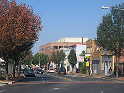
neighborhood, MLK Ave changes from a primarily residential neighborhood to a commercial district. Also in the Congress Heights area, MLK Ave crosses both Alabama Avenue SE and Malcolm X Ave SE. After leaving Congress Heights, the street turns north, crossing throughout the campus of St. Elizabeths Hospital
St. Elizabeths Hospital
St. Elizabeths Hospital is a psychiatric hospital operated by the District of Columbia Department of Mental Health. It was the first large-scale, federally-run psychiatric hospital in the United States. Housing several thousand patients at its peak, St. Elizabeths had a fully functioning...
, the future home of the Department of Homeland Security. MLK Ave stays headed north, crossing the Suitland Parkway
Suitland Parkway
The Suitland Parkway is a parkway in Washington, D.C., and Prince George's County, Maryland, maintained by the U.S. National Park Service. Conceived in 1937, it was built during World War II to provide a road connection between military facilities in the Washington, D.C., metropolitan area, and...
before reaching the Anacostia Metro Station. After passing the Anacostia Station, MLK Ave enters historic Anacostia
Anacostia
Anacostia is a historic neighborhood in Washington, D.C. Its historic downtown is located at the intersection of Good Hope Road and Martin Luther King, Jr. Avenue It is the most famous neighborhood in the Southeast quadrant of Washington, located east of the Anacostia River, after which the...
, crossing Good Hope Road before terminating at the 11th Street Bridges
11th Street Bridges
The 11th Street Bridges are a pair of one-way bridges across the Anacostia River in Washington, D.C., U.S.A. The southbound structure is officially named the Officer Kevin J. Welsh Memorial Bridge, while the northbound structure is officially named the 11th Street Bridge. The bridges convey...
.
History
In 2003, the District of Columbia Department of Transportation
District of Columbia Department of Transportation
The District of Columbia Department of Transportation is an agency of the government of the District of Columbia which manages and maintains publicly-owned transportation infrastructure in the District of Columbia...
(DDOT) announced that, as part of its DC Streetcar
DC Streetcar
The DC Streetcar is a surface light rail and streetcar network under construction in Washington, D.C. The streetcars will be the first to run in the District of Columbia since the dismantling of the previous streetcar system in 1962...
system, it would build a 2.7 miles (4.3 km) "Anacostia Line" as a demonstration of streetcar technology in the city. The line was planned to begin at Bolling Air Force Base
Bolling Air Force Base
Joint Base Anacostia-Bolling is a military installation, located in Southeast Washington, D.C., established on 1 October 2010 in accordance with congressional legislation implementing the recommendations of the 2005 Base Realignment and Closure Commission...
, travel up north along South Capitol Street
South Capitol Street
South Capitol Street is a major street dividing the southeast and southwest quadrants of Washington, D.C. It runs south from the United States Capitol to the Washington-Maryland line...
to the Anacostia Metro station
Anacostia (Washington Metro)
Anacostia is a Washington Metro station in Washington, D.C. on the Green Line. The station is located in the Anacostia neighborhood of Southeast Washington, with entrances at Shannon Place and Howard Road near Martin Luther King, Jr. Avenue SE . The station serves as a hub for Metrobus routes in...
, along Martin Luther King, Jr. Avenue SE to Good Hope Road SE, and then along the CSX railroad tracks to the Minnesota Avenue Metro station. However, in October 2010 the city scaled back the Anacostia Line, truncating the northern end of the line so that it would only end at the Anacostia Metro station. However, on March 4, 2011, DDOT announced public meetings designed to provide a link between the Anacostia Metro Station and the 11th Street Bridges
11th Street Bridges
The 11th Street Bridges are a pair of one-way bridges across the Anacostia River in Washington, D.C., U.S.A. The southbound structure is officially named the Officer Kevin J. Welsh Memorial Bridge, while the northbound structure is officially named the 11th Street Bridge. The bridges convey...
(under construction as of early 2011) which would meet community concerns about traffic impacts the streetcar would have on MLK Ave, threats to historic preservation in the Anacostia Historic District
Anacostia Historic District
The Anacostia Historic District is a historic district in the city of Washington, D.C., comprising approximately 20 squares and about 550 buildings built between 1854 and 1930. The Anacostia Historic District was added to the National Register of Historic Places in 1978. "The architectural...
, and terminating the line at the Anacostia Gateway building at the intersection of MLK Ave and Good Hope Road SE. The 11th Street Bridges are designed to carry streetcars over the Anacostia River
Anacostia River
The Anacostia River is a river in the Mid Atlantic region of the United States. It flows from Prince George's County in Maryland into Washington, D.C., where it joins with the Washington Channel to empty into the Potomac River at Buzzard Point. It is approximately long...
, permitting the Anacostia Line to link with the rest of the streetcar system.
Transportation
The Anacostia Metrorail Station lies on Howard Road Southeast, just off of MLK Avenue.- Anacostia Station
Metrobus
Metrobus (Washington, D.C.)
Metrobus is a bus service operated by the Washington Metropolitan Area Transit Authority . Its fleet consists of 1,480 buses covering an area of in Washington, D.C., Maryland, and Virginia. There are over 300 bus routes serving 12,216 stops, including 2,398 bus shelters. In fiscal year 2009,...
lines A2, A4, A5, A6, A7, A8, A33, A42, A46, A48, M8, M9, P1, P2, P6, W2, W3, 90, 92, and 93 serve MLK Ave, with many others crossing the street.
For more information, see List of Metrobus routes