

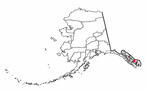
Wrangell Island
Encyclopedia
Island
An island or isle is any piece of sub-continental land that is surrounded by water. Very small islands such as emergent land features on atolls can be called islets, cays or keys. An island in a river or lake may be called an eyot , or holm...
is in the Alexander Archipelago
Alexander Archipelago
The Alexander Archipelago is a long archipelago, or group of islands, of North America off the southeastern coast of Alaska. It contains about 1,100 islands, which are the tops of the submerged coastal mountains that rise steeply from the Pacific Ocean. Deep channels and fjords separate the...
in the Alaska Panhandle
Alaska Panhandle
Southeast Alaska, sometimes referred to as the Alaska Panhandle, is the southeastern portion of the U.S. state of Alaska, which lies west of the northern half of the Canadian province of British Columbia. The majority of Southeast Alaska's area is part of the Tongass National Forest, the United...
of southeastern Alaska
Alaska
Alaska is the largest state in the United States by area. It is situated in the northwest extremity of the North American continent, with Canada to the east, the Arctic Ocean to the north, and the Pacific Ocean to the west and south, with Russia further west across the Bering Strait...
. It is 48 km (29.8 mi) long and 8–23 km (3–14 miles) wide. It has a land area of 544.03 km² (210.1 sq mi), making it the 29th largest island in the United States. Wrangell is separated from the mainland by the narrow Blake Channel
Blake Channel
Blake Channel is a channel in Southeast Alaska, U.S.A. It extends , separating the southeastern part of Wrangell Island from the mainland. It was first traversed and charted in 1793 by James Johnstone, one of George Vancouver's officers during his 1791-95 expedition....
.
The first Europe
Europe
Europe is, by convention, one of the world's seven continents. Comprising the westernmost peninsula of Eurasia, Europe is generally 'divided' from Asia to its east by the watershed divides of the Ural and Caucasus Mountains, the Ural River, the Caspian and Black Seas, and the waterways connecting...
an to sight the island was James Johnstone
James Johnstone (explorer)
James Johnstone was a British naval officer and explorer. He is noted for having served as sailing master of the armed tender HMS Chatham and later acting lieutenant during George Vancouver’s 1791-95 expedition to the Pacific Northwest...
, one of George Vancouver
George Vancouver
Captain George Vancouver RN was an English officer of the British Royal Navy, best known for his 1791-95 expedition, which explored and charted North America's northwestern Pacific Coast regions, including the coasts of contemporary Alaska, British Columbia, Washington and Oregon...
’s officers during his 1791-95 expedition
Vancouver Expedition
The Vancouver Expedition was a four-and-a-half-year voyage of exploration and diplomacy, commanded by Captain George Vancouver. The expedition circumnavigated the globe, touched five continents and changed the course of history for the indigenous nations and several European empires and their...
, in 1793. He only charted its east coast, not realizing it was an island. It was occupied in 1834 by the Russia
Russia
Russia or , officially known as both Russia and the Russian Federation , is a country in northern Eurasia. It is a federal semi-presidential republic, comprising 83 federal subjects...
ns. It is named after Ferdinand Wrangel
Ferdinand von Wrangel
Baron Ferdinand Friedrich Georg Ludwig von Wrangel – May 25 , 1870) was a Russian explorer and seaman, Honorable Member of the Saint Petersburg Academy of Sciences, a founder of the Russian Geographic Society...
, a Baltic German
Baltic German
The Baltic Germans were mostly ethnically German inhabitants of the eastern shore of the Baltic Sea, which today form the countries of Estonia and Latvia. The Baltic German population never made up more than 10% of the total. They formed the social, commercial, political and cultural élite in...
explorer in Russian service, and government official. From 1867 to 1877 it was a U.S. military post; later it became an outfitting point for hunters and explorers, and for miners using the Stikine River route to the Yukon
Yukon
Yukon is the westernmost and smallest of Canada's three federal territories. It was named after the Yukon River. The word Yukon means "Great River" in Gwich’in....
.
The island contains the city of Wrangell, Alaska
Wrangell, Alaska
Wrangell is a city and borough in the U.S. state of Alaska. At the 2000 census the population was 2,308.Its Tlingit name is Ḵaachx̱aana.áakʼw . The Tlingit people residing in the Wrangell area, who were there centuries before Europeans, call themselves the Shtaxʼhéen Ḵwáan after the nearby Stikine...
. Wrangell Island is heavily forested and contains an abundance of wildlife. The only other community is Thoms Place
Thoms Place, Alaska
Thoms Place is a former census-designated place on Wrangell Island in the city of Wrangell, Alaska, United States. The population was 22 at the 2000 census, at which time it was an unincorporated part of the former Wrangell-Petersburg Census Area, Alaska...
on the southwest side, across the Zimovia Strait
Zimovia Strait
Zimovia Strait is a narrow strait in the Alexander Archipelago in the U.S. state of Alaska. It is about 100 km long and bounded by Wrangell Island to the east and Woronkofski and Etolin Islands to the west...
from Etolin Island
Etolin Island
Etolin Island is an island in the Alexander Archipelago of southeastern Alaska, USA, at . It is between Prince of Wales Island, to its west, and the Alaska mainland, to its east. It is southwest of Wrangell Island. It was first charted in 1793 by James Johnstone, one of George Vancouver's...
. Wrangell Island's total population was 2,401 at the 2000 census
United States Census, 2000
The Twenty-second United States Census, known as Census 2000 and conducted by the Census Bureau, determined the resident population of the United States on April 1, 2000, to be 281,421,906, an increase of 13.2% over the 248,709,873 persons enumerated during the 1990 Census...
.
Fishing and mining are pursued in the area. A lumber mill closed in 1990s. The island and surrounding areas contain many recreational areas. It is at the mouth of the Stikine River
Stikine River
The Stikine River is a river, historically also the Stickeen River, approximately 610 km long, in northwestern British Columbia in Canada and southeastern Alaska in the United States...
, which provides many recreational opportunities.