
.gif)
Tropical Storm Andrew (1986)
Encyclopedia
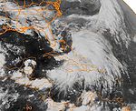
Tropical Storm Andrew was a small, moderate tropical storm that formed in early June 1986. The first named storm of the 1986 Atlantic hurricane season
, Andrew developed from a large, northward bound area of disturbed weather. Although it reached its peak intensity as a tropical storm, the initial depression was subtropical
. After being named, Andrew briefly threatened the Carolinas before recurving out to sea at a forward speed of 23 mi/h, being absorbed by an area of low pressure over east Canada
.
Despite moving in close proximity to Cape Hatteras
, no reports of storm conditions were received, largely due to the highest concentration of activity being on the east side of the storm. The storm was responsible for one death due to undertow
while active. However, the area of disturbed weather that ultimately developed into Andrew was responsible for landslides and flooding that claimed 49 lives in Jamaica
. With a total of 50 deaths, both direct and indirect, Andrew was the deadliest storm of the season. Despite the death toll, there is no known damage total from the storm.
, bringing heavy rains to the islands. The area moved northward until, on June 5, satellite imagery showed a circulation developing over the Bahamas. Observations from the islands indicated that a depression had formed, and upper-level winds nearby indicated cyclonic flow, a characteristic typical of subtropical cyclones. As a result, the system was determined to have become a subtropical depression early that day. The depression continued generally northward, eventually turning to the northwest and strengthening into a tropical storm on June 6 while 258 mi (415.2 km) southeast of Charleston
, South Carolina
.
After being named, the tropical storm moved closer towards the South Carolina coast, eventually coming within 115 mi (185.1 km) of making landfall before recurving to the northeast on June 7. The storm moved in close range to Cape Hatteras while recurving, coming closer to landfall there, at 69 mi (111 km) away, than it did near South Carolina. During the period when it threatened the East Coast of the United States
, the storm had sustained winds of 50 mi/h and a pressure of 999 mbar. The storm accelerated to the northeast, briefly crossing into the forecasting territory of Environment Canada
, the first of three storms of the season to do so, before ultimately being absorbed by a low pressure system over Canada
on June 8.
on June 7. Probability charts showing possible locations Andrew could pass near gave the highest probabilities to Cape Hatteras and Morehead City
at 40% and 30% respectively. In South Carolina
, Myrtle Beach
and Charleston had 28% and 21% respectively. Outside the Carolinas, the only locations to have probabilities 10% or higher were Savannah, Georgia
at 15%, Norfolk, Virginia
at 14%, Ocean City, Maryland
at 11%, and Sable Island
at 10%. The main threat expected from the tropical storm was heavy waves.
 While off the Carolina coast, the storm triggered waves of 6 feet (1.8 m) to 8 feet (2.4 m), sometimes as high as 12 feet (3.7 m); the most that any location on land experienced from the storm. South Carolina also reported slight rains associated with the storm, but little else. The storm also caused undertow, which claimed its only life as tropical storm when a swimmer, Jeanne Doane, was swept into the ocean at Ocracoke Island
. Three companions were also swept out, all of whom made it back to shore. An additional sixteen swimmers at Wrightsville Beach were reported as getting caught in the currents, two of which ended up having to be treated at Cape Fear Memorial Hospital and were later discharged. All of the swimmers were rescued. Carolina Beach also recorded that twenty-five to thirty others were rescued there, with two being hospitalized when their lungs contracted water. Unusually, despite gale warnings being in place, no reports of sustained winds of that strength were received by the National Hurricane Center
, due to the majority of high winds and rain being concentrated on the east side of the circulation.
While the storm did not affect Jamaica while active, the precursor disturbance to Andrew brought heavy rains to the island, causing landslides and flooding. A total of 49 people were reported to have been killed by the disturbance, and more were driven from their homes by the flooding. A total of one thousand people had to be evacuated from the storm. Heavy rains also caused the disruption of many water supplies across the island. The damaged water supplies also caused contamination
in Westmoreland, Clarendon, and locations in St. Catherine. The hardest hit area for pollution was St. Mary, which had cases of typhoid due to contaminated water. Lightning was responsible for causing problems for power supplies and power lines and poles were reported destroyed. Some utility stations around the island were either flooded, broken, and in one case, damaged by lightning. Other utilities, including transport, sewage, and communications were also affected, but to less of an extent.
With a total of 50 deaths caused by the cyclone, Andrew was the deadliest named storm of the season. This was the first time that an Atlantic tropical cyclone was named Andrew, following the retirement of Allen
.
1986 Atlantic hurricane season
The 1986 Atlantic hurricane season officially began on June 1, 1986, and lasted until November 30, 1986. These dates conventionally delimit the period of each year when most tropical cyclones form in the Atlantic basin...
, Andrew developed from a large, northward bound area of disturbed weather. Although it reached its peak intensity as a tropical storm, the initial depression was subtropical
Subtropical cyclone
A subtropical cyclone is a weather system that has some characteristics of a tropical and an extratropical cyclone. As early as the 1950s, meteorologists were unclear whether they should be characterized as tropical or extratropical cyclones. They were officially recognized by the National...
. After being named, Andrew briefly threatened the Carolinas before recurving out to sea at a forward speed of 23 mi/h, being absorbed by an area of low pressure over east Canada
Canada
Canada is a North American country consisting of ten provinces and three territories. Located in the northern part of the continent, it extends from the Atlantic Ocean in the east to the Pacific Ocean in the west, and northward into the Arctic Ocean...
.
Despite moving in close proximity to Cape Hatteras
Cape Hatteras
Cape Hatteras is a cape on the coast of North Carolina. It is the point that protrudes the farthest to the southeast along the northeast-to-southwest line of the Atlantic coast of North America...
, no reports of storm conditions were received, largely due to the highest concentration of activity being on the east side of the storm. The storm was responsible for one death due to undertow
Undertow (wave action)
Undertow is a subsurface flow of water returning seaward from shore as result of wave action. This type of shore current can play a role in material deposition such as creating sand bars....
while active. However, the area of disturbed weather that ultimately developed into Andrew was responsible for landslides and flooding that claimed 49 lives in Jamaica
Jamaica
Jamaica is an island nation of the Greater Antilles, in length, up to in width and 10,990 square kilometres in area. It is situated in the Caribbean Sea, about south of Cuba, and west of Hispaniola, the island harbouring the nation-states Haiti and the Dominican Republic...
. With a total of 50 deaths, both direct and indirect, Andrew was the deadliest storm of the season. Despite the death toll, there is no known damage total from the storm.
Meteorological history
In early June, a large area of disturbed weather persisted over the Greater AntillesGreater Antilles
The Greater Antilles are one of three island groups in the Caribbean. Comprising Cuba, Jamaica, Hispaniola , and Puerto Rico, the Greater Antilles constitute almost 90% of the land mass of the entire West Indies.-Greater Antilles in context :The islands of the Caribbean Sea, collectively known as...
, bringing heavy rains to the islands. The area moved northward until, on June 5, satellite imagery showed a circulation developing over the Bahamas. Observations from the islands indicated that a depression had formed, and upper-level winds nearby indicated cyclonic flow, a characteristic typical of subtropical cyclones. As a result, the system was determined to have become a subtropical depression early that day. The depression continued generally northward, eventually turning to the northwest and strengthening into a tropical storm on June 6 while 258 mi (415.2 km) southeast of Charleston
Charleston, South Carolina
Charleston is the second largest city in the U.S. state of South Carolina. It was made the county seat of Charleston County in 1901 when Charleston County was founded. The city's original name was Charles Towne in 1670, and it moved to its present location from a location on the west bank of the...
, South Carolina
South Carolina
South Carolina is a state in the Deep South of the United States that borders Georgia to the south, North Carolina to the north, and the Atlantic Ocean to the east. Originally part of the Province of Carolina, the Province of South Carolina was one of the 13 colonies that declared independence...
.
After being named, the tropical storm moved closer towards the South Carolina coast, eventually coming within 115 mi (185.1 km) of making landfall before recurving to the northeast on June 7. The storm moved in close range to Cape Hatteras while recurving, coming closer to landfall there, at 69 mi (111 km) away, than it did near South Carolina. During the period when it threatened the East Coast of the United States
East Coast of the United States
The East Coast of the United States, also known as the Eastern Seaboard, refers to the easternmost coastal states in the United States, which touch the Atlantic Ocean and stretch up to Canada. The term includes the U.S...
, the storm had sustained winds of 50 mi/h and a pressure of 999 mbar. The storm accelerated to the northeast, briefly crossing into the forecasting territory of Environment Canada
Environment Canada
Environment Canada , legally incorporated as the Department of the Environment under the Department of the Environment Act Environment Canada (EC) (French: Environnement Canada), legally incorporated as the Department of the Environment under the Department of the Environment Act Environment...
, the first of three storms of the season to do so, before ultimately being absorbed by a low pressure system over Canada
Canada
Canada is a North American country consisting of ten provinces and three territories. Located in the northern part of the continent, it extends from the Atlantic Ocean in the east to the Pacific Ocean in the west, and northward into the Arctic Ocean...
on June 8.
Preparations
While active, Andrew posed a threat to the Carolinas. Gale warnings were posted from an area ranging from Cape Lookout to south of Virginia Beach, VirginiaVirginia Beach, Virginia
Virginia Beach is an independent city located in the Hampton Roads metropolitan area of Virginia, on the Atlantic Ocean at the mouth of the Chesapeake Bay...
on June 7. Probability charts showing possible locations Andrew could pass near gave the highest probabilities to Cape Hatteras and Morehead City
Morehead City, North Carolina
Morehead City is a port city in Carteret County, North Carolina, United States. The population was 8,661 at the 2010 census. Morehead City celebrated the 150th anniversary of its founding on May 5, 2007...
at 40% and 30% respectively. In South Carolina
South Carolina
South Carolina is a state in the Deep South of the United States that borders Georgia to the south, North Carolina to the north, and the Atlantic Ocean to the east. Originally part of the Province of Carolina, the Province of South Carolina was one of the 13 colonies that declared independence...
, Myrtle Beach
Myrtle Beach, South Carolina
Myrtle Beach is a coastal city on the east coast of the United States in Horry County, South Carolina. It is situated on the center of a large and continuous stretch of beach known as the Grand Strand in northeastern South Carolina. It is considered to be a major tourist destination in the...
and Charleston had 28% and 21% respectively. Outside the Carolinas, the only locations to have probabilities 10% or higher were Savannah, Georgia
Savannah, Georgia
Savannah is the largest city and the county seat of Chatham County, in the U.S. state of Georgia. Established in 1733, the city of Savannah was the colonial capital of the Province of Georgia and later the first state capital of Georgia. Today Savannah is an industrial center and an important...
at 15%, Norfolk, Virginia
Norfolk, Virginia
Norfolk is an independent city in the Commonwealth of Virginia in the United States. With a population of 242,803 as of the 2010 Census, it is Virginia's second-largest city behind neighboring Virginia Beach....
at 14%, Ocean City, Maryland
Ocean City, Maryland
Ocean City, sometimes known as OC, or OCMD, is an Atlantic Ocean resort town in Worcester County, Maryland, United States. Ocean City is widely known in the Mid-Atlantic region of the United States and is a frequent destination for vacationers in that area...
at 11%, and Sable Island
Sable Island
Sable Island is a small Canadian island situated 300 km southeast of mainland Nova Scotia in the Atlantic Ocean. The island is a year-round home to approximately five people...
at 10%. The main threat expected from the tropical storm was heavy waves.
Impact
Ocracoke, North Carolina
Ocracoke is a census-designated place and unincorporated town located at the southern end of Ocracoke Island, located entirely within Hyde County, North Carolina. The population was 769 as of the 2000 census...
. Three companions were also swept out, all of whom made it back to shore. An additional sixteen swimmers at Wrightsville Beach were reported as getting caught in the currents, two of which ended up having to be treated at Cape Fear Memorial Hospital and were later discharged. All of the swimmers were rescued. Carolina Beach also recorded that twenty-five to thirty others were rescued there, with two being hospitalized when their lungs contracted water. Unusually, despite gale warnings being in place, no reports of sustained winds of that strength were received by the National Hurricane Center
National Hurricane Center
The National Hurricane Center , located at Florida International University in Miami, Florida, is the division of the National Weather Service responsible for tracking and predicting weather systems within the tropics between the Prime Meridian and the 140th meridian west poleward to the 30th...
, due to the majority of high winds and rain being concentrated on the east side of the circulation.
While the storm did not affect Jamaica while active, the precursor disturbance to Andrew brought heavy rains to the island, causing landslides and flooding. A total of 49 people were reported to have been killed by the disturbance, and more were driven from their homes by the flooding. A total of one thousand people had to be evacuated from the storm. Heavy rains also caused the disruption of many water supplies across the island. The damaged water supplies also caused contamination
Water pollution
Water pollution is the contamination of water bodies . Water pollution occurs when pollutants are discharged directly or indirectly into water bodies without adequate treatment to remove harmful compounds....
in Westmoreland, Clarendon, and locations in St. Catherine. The hardest hit area for pollution was St. Mary, which had cases of typhoid due to contaminated water. Lightning was responsible for causing problems for power supplies and power lines and poles were reported destroyed. Some utility stations around the island were either flooded, broken, and in one case, damaged by lightning. Other utilities, including transport, sewage, and communications were also affected, but to less of an extent.
With a total of 50 deaths caused by the cyclone, Andrew was the deadliest named storm of the season. This was the first time that an Atlantic tropical cyclone was named Andrew, following the retirement of Allen
Hurricane Allen
Hurricane Allen was the first and strongest hurricane of the 1980 Atlantic hurricane season. It was one of the strongest hurricanes in recorded history, one of the few hurricanes to reach Category 5 status on the Saffir-Simpson Hurricane Scale on three separate occasions, and spent more time...
.